
Mullayyana Giri
| Mullayyanagiri ಮುಳ್ಳಯ್ಯನಗಿರಿ (Mulayyanagiri) | |
|---|---|
| ಮೇಲ್ಗದ್ದುಗೆ (Melgadduge) | |
| File:Picture 6.jpg Mullayyanagiri Peak | |
| Highest point | |
| Elevation | 1,930 m (6,330 ft) |
| Naming | |
| English translation | ಮುಳ್ಳಯ್ಯನಗಿರಿ |
| Language of name | Kannada |
| Geography | |
 Mullayyanagiri ಮುಳ್ಳಯ್ಯನಗಿರಿ (Mulayyanagiri) Location of Mullayyanagiri, Karnataka | |
| Location | Chikkamagaluru, Karnataka, India |
| Parent range | Baba Budan Giri Range |
Mullayyanagiri (Kannada: ಮುಳ್ಳಯ್ಯನಗಿರಿ)is the highest peak in Karnataka, India. Mullayyanagiri is located at 13°23′26″N 75°43′18″E / 13.39056°N 75.72167°E in the Chandra Dhrona Hill Ranges of the Western Ghats of Chikkamagaluru Taluk. With a height of 1,930 metres (6,330 ft), it is the highest peak between the Himalayas and the Nilgiris. Mullayyanagiri is one of the best trekking places in Karnataka and South India. The Sunset presents a spectacular view from the peak. The summit of Mulayyanagiri also houses a police radio relay station.
Temple
The peak gets its name from a small temple (gadduge/tomb) at the summit, which is dedicated to a Tapasvi "Mulappa swamy" who, is believed to have meditated at the caves only a couple of feet below the summit. The caves are accessible and not very deep, they have a direct entrance to the garbagudi of the temple, which is now blocked by the temple priests. Apart from multiple versions of folklore and strong Siddha culture around the belt, the origins or any information about the deity remains ambiguous.
Trekking
Anciently, when the present asphalt roads and the 300 concrete steps were not present, a trail was used to reach the peak, known as 'Sarpadari' or 'sarpanadi'. Although it is not very frequently visited now, this trail is cherished by trekkers.
-
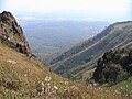 On the way to Mullayyanagiri

See also
- Nandi Hills
- Malnad
- Chamundi Hills
- Kemmangundi
- Kudremukh
- Nilgiris (mountains)
- Himalayas
- Kodaikanal
- Devaramane
External links
This article related to a location in Chikkamagaluru district, Karnataka, India is a stub. You can help Wikipedia by expanding it. |