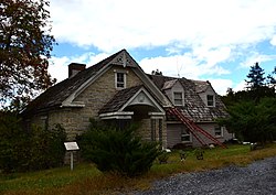
Hupp House
Appearance
Hupp House | |
 Hupp House, September 2013 | |
| Location | 551 N. Massanutten St., near Strasburg, Virginia |
|---|---|
| Coordinates | 38°59′42″N 78°21′22″W / 38.99500°N 78.35611°W |
| Area | 1.6 acres (0.65 ha) |
| Built | c. 1755 |
| Architectural style | Colonial |
| NRHP reference No. | 97000155[1] |
| VLR No. | 085-0007 |
| Significant dates | |
| Added to NRHP | February 21, 1997 |
| Designated VLR | December 4, 1996[2] |
Hupp House, also known as the Frontier Fort and Hupp Homestead, is a historic home located in Strasburg, Shenandoah County, Virginia. It was built about 1755, and is a 4-story, rubble limestone Colonial-era dwelling. It is on a banked site and measures 20 feet wide by 40 feet deep. A concrete block east wing was added in 1956. The house has a steep gable roof and features a traditional Germanic central chimney and the interior framing appears original, with heavy traditional Germanic beams and roof structure. It is one of the oldest extant dwellings erected by Germanic settlers in Shenandoah County.[3]
It was listed on the National Register of Historic Places in 1997.[1]
References
[edit]- ^ a b "National Register Information System". National Register of Historic Places. National Park Service. July 9, 2010.
- ^ "Virginia Landmarks Register". Virginia Department of Historic Resources. Retrieved 2013-03-12.
- ^ James C. Massey and Shirley Maxwell (September 1996). "National Register of Historic Places Inventory/Nomination: Hupp House" (PDF). Virginia Department of Historic Resources. and Accompanying photo
Categories:
- German-American culture in Virginia
- Houses on the National Register of Historic Places in Virginia
- Colonial architecture in Virginia
- Houses completed in 1755
- Houses in Shenandoah County, Virginia
- National Register of Historic Places in Shenandoah County, Virginia
- Shenandoah Valley, Virginia Registered Historic Place stubs


