Hook–Powell–Moorman Farm
Hook–Powell–Moorman Farm | |
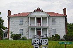
 Front of the house | |
| Location | Jct. of VA 122 and VA 950, near Hales Ford, Virginia |
|---|---|
| Coordinates | 37°8′23″N 79°40′48″W / 37.13972°N 79.68000°W |
| Area | 60 acres (24 ha) |
| Built | 1784 |
| Architectural style | Georgian, Greek Revival |
| NRHP reference No. | 95000893[1] |
| VLR No. | 033-0022 |
| Significant dates | |
| Added to NRHP | July 21, 1995 |
| Designated VLR | April 28, 1995[2] |
Hook–Powell–Moorman Farm is a historic farm complex and national historic district located near Hales Ford, Franklin County, Virginia. It encompasses three contributing buildings and 10 contributing sites. The buildings are the Greek Revival-style farmhouse (c. 1855); a one-story frame building with Georgian detailing identified as the John Hook Store (c. 1784); and the Dr. John A. Moorman Office (c. 1890). The sites are those of an ice house, carriage house, workshop, barn, outbuilding, original site of the store, a house, spring, ice pond, and road bed.[3]
It was listed on the National Register of Historic Places in 1995.[1]
References[edit]
- ^ a b "National Register Information System". National Register of Historic Places. National Park Service. July 9, 2010.
- ^ "Virginia Landmarks Register". Virginia Department of Historic Resources. Retrieved June 5, 2013.
- ^ J. Daniel Pezzoni (February 1995). "National Register of Historic Places Inventory/Nomination: Hook–Powell–Moorman Farm" (PDF). Virginia Department of Historic Resources. and Accompanying photo
External links[edit]
- Hook–Powell–Moorman Farm, Hook's Store, VA 122 & SR 950 (Dovetail Lane), Hales Ford (historical), Franklin County, VA at the Historic American Buildings Survey (HABS)
Categories:
- Farms on the National Register of Historic Places in Virginia
- Historic districts in Franklin County, Virginia
- National Register of Historic Places in Franklin County, Virginia
- Historic American Buildings Survey in Virginia
- Historic districts on the National Register of Historic Places in Virginia
- Blue Ridge Highlands, Virginia Registered Historic Place stubs


