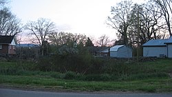
Jonesville Methodist Campground
Appearance
Jonesville Methodist Campground | |
 Buildings at the campground | |
| Location | West of Jonesville at the junction of U.S. Route 58 and State Route 652, near Jonesville, Virginia |
|---|---|
| Coordinates | 36°40′57″N 83°8′38″W / 36.68250°N 83.14389°W |
| Area | 1 acre (0.40 ha) |
| Built | 1810 |
| NRHP reference No. | 74002133[1] |
| VLR No. | 052-0007 |
| Significant dates | |
| Added to NRHP | May 16, 1974 |
| Designated VLR | July 17, 1973[2] |
Jonesville Methodist Campground is a historic Methodist campground located near Jonesville, Lee County, Virginia. The property consists of a broad lawn where the congregation erect their tents, and the permanent pavilion-like auditorium. The auditorium is a gable roofed structure measuring 76 feet long and 36 feet wide, with a 12 feet deep shed addition. The camp ground land was given to the trustees of the Methodist Church in 1827 by Elkanah Wynn.[3]
It was listed on the National Register of Historic Places in 1974.[1]
References
[edit]- ^ a b "National Register Information System". National Register of Historic Places. National Park Service. July 9, 2010.
- ^ "Virginia Landmarks Register". Virginia Department of Historic Resources. Retrieved 5 June 2013.
- ^ Virginia Historic Landmarks Commission Staff (1977). "National Register of Historic Places Inventory/Nomination: Jonesville Methodist Campground" (PDF). Virginia Department of Historic Resources. and Accompanying photo


