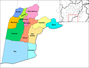
Panjwayi District

Panjwai (also spelled Panjwaye, Panjwaii, Panjway or Panjwayi) is a district in Kandahar Province, Afghanistan. It is known as the birthplace of the Taliban. It is located about 35 kilometres (20 miles) west of Kandahar city. The district borders Helmand Province to the southwest, Maywand District to the west, Khakrez District to the north, Arghandab, Kandahar and Daman districts to the east and Reg District to the south. The population is 77,200 (2006). The district center is Bazar-e Panjwai, located in the northern part of the district.
Battle of Panjwaii
The district was the scene of the Battle of Panjwaii involving Canadian Forces and Taliban fighters and the theatre of the ISAF Operation Medusa, September 2006. NATO claimed to have killed over 500 Taliban insurgents. [1]
Other events
On 16 November 2009 Canadian troops captured the Taliban-controlled village of Hajji Baba southwest of Kandahar City.[1]
References
- ^ Matthew Fisher. "Taliban abandon village to Canadian troops." Canwest News Service, November 17, 2009. Accessed at: http://www.afghanemb-canada.net/en/news_bulletin/2009/Nov/17/index.php
31°32′52″N 65°27′15″E / 31.54778°N 65.45417°E
