Cotabato City: Difference between revisions
BOT--Reverting link addition(s) by Cotabatocity to revision 378103696 (http://www.cotabatocitysp.webs.com) |
No edit summary Tag: possible conflict of interest |
||
| Line 122: | Line 122: | ||
*Old Cotabato City Hall - A century old structure which houses almost all of the city government offices. It showcases the architectural design of the Maguindanaon Art. |
*Old Cotabato City Hall - A century old structure which houses almost all of the city government offices. It showcases the architectural design of the Maguindanaon Art. |
||
*Takumi Butai Memorial Shrine - A monument in honor of Takumi Butai and the Japanese soldiers who died here during the [[Second World War]]. Takumi was the Provincial Commander of the Japanese forces assigned in Cotabato City. Before he died, he requested that some of his ashes be buried in Cotabato City. This shrine was put up by the Lion's Club of Kyoto, Japan in cooperation with the City Government of Cotabato. |
*Takumi Butai Memorial Shrine - A monument in honor of Takumi Butai and the Japanese soldiers who died here during the [[Second World War]]. Takumi was the Provincial Commander of the Japanese forces assigned in Cotabato City. Before he died, he requested that some of his ashes be buried in Cotabato City. This shrine was put up by the Lion's Club of Kyoto, Japan in cooperation with the City Government of Cotabato. |
||
==External links== |
==External links== |
||
*[http://www.cotabatocity.gov.ph Cotabato City Website] |
*[http://www.cotabatocity.gov.ph Cotabato City Website] |
||
*[http://www.cotabatocitysp.com Sangguniang Panlungsod Cotabato City Website] |
|||
*[http://www.nscb.gov.ph/activestats/psgc/default.asp Philippine Standard Geographic Code] |
*[http://www.nscb.gov.ph/activestats/psgc/default.asp Philippine Standard Geographic Code] |
||
*[http://cotabatocity.info/ Cotabato City] |
*[http://cotabatocity.info/ Cotabato City] |
||
Revision as of 09:46, 1 September 2010
Cotabato | |
|---|---|
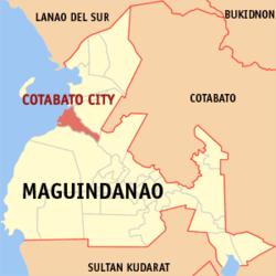
 Map of Maguindanao showing the location of Cotabato City. | |
| Country | |
| Region | SOCCSKSARGEN (Region XII) |
| Province | — |
| District | Lone District of Maguindanao |
| Cityhood | June 20, 1959 |
| Barangays | 37 |
| Government | |
| • Mayor | Japal "JoJo" Guiani |
| • Vice-Mayor | Datu Muslimin G. Sema |
| Area | |
| • Total | 176.00 km2 (67.95 sq mi) |
| Population (2007) | |
| • Total | 259,153 |
| • Density | 1,500/km2 (3,800/sq mi) |
| Time zone | UTC+8 (PHT) |
| Income class | 2nd class city |
| Website | Official website |
Cotabato City is one of the cities of the Philippines located in Mindanao. Cotabato City is an exclave of the SOCCSKSARGEN region found within the boundaries of Maguindanao province, but is independent of that province. Cotabato City is distinct from and should not be confused with the province of Cotabato.
Cotabato City is the regional center of the Autonomous Region in Muslim Mindanao but the city is actually part of the SOCCSKSARGEN region and does not belong to the ARMM.
Cotabato's population was about 259,153 in 2007 census.
Cotabato is approximately 698.9 nautical miles (1294 km) from Manila, the country's capital, and is bounded by the municipalities of Sultan Kudarat to the north—with Rio Grande de Mindanao separating the two—Kabuntalan to the east, and Datu Odin Sinsuat to the south. The city faces Illana Bay, part of the Moro Gulf, to the west. Cotabato City has a total land area of 176.0 square kilometers.
Barangays
Cotabato City is politically subdivided into 37 barangays.
|
|
|
Tourist attractions
- Rio Grande de Mindanao. The second largest river in the Philippines and the longest in Mindanao crisscrossing, with its tributary, the city's vast area. Estimated to be 182 kilometers long and 96 meters wide. Water sports and boat racing are the popular attractions of the river, usually held to coincide with the Shariff Kabunsuan Festival and the Feast of Hariraya Puasa.
- Tamontaka Church - Built in 1872 of Spanish architecture and design. It is the oldest church in the city , a relic of the living past.
- Lourdes Grotto - A replica of Our Lady of Lourdes Grotto in France. The compound is equipped with a retreat house for recollection and seminars, a mini zoo and a children's park.
- Kutang Bato Caves - The only cave in the country that is right in the heart of the city. Its various entrances, all within traffic a rarity that can only be had in the "Heart of Mindanao". These caves were also the source of the city's present name for "Kuta" means "Fort" and "Bato" means "Stone" hence the name "Fort of Stone" which later on became Cotabato.
- Old Cotabato City Hall - A century old structure which houses almost all of the city government offices. It showcases the architectural design of the Maguindanaon Art.
- Takumi Butai Memorial Shrine - A monument in honor of Takumi Butai and the Japanese soldiers who died here during the Second World War. Takumi was the Provincial Commander of the Japanese forces assigned in Cotabato City. Before he died, he requested that some of his ashes be buried in Cotabato City. This shrine was put up by the Lion's Club of Kyoto, Japan in cooperation with the City Government of Cotabato.
