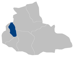
Muqur District, Badghis
Appearance
Muqur | |
|---|---|
 Muqur District within Badghis Province | |
| Country | Afghanistan |
| Province | Padghis |
| Government | |
| • Type | District council |
| Area | |
| • Total | 1,133 km2 (437 sq mi) |
Muqur District is a district located within Badghis Province in the western part of Afghanistan. It is located between the districts of Ab Kamari to the east, Qala i Naw to the south, Qadis to the southeast and Murghab to the northeast. To the north is the national border with Turkmenistan. The district is in a long river valley.
References
