Namasia District
23°16′18″N 120°43′33″E / 23.271627°N 120.725906°E
Namasia
那瑪夏區 Namaxia | |
|---|---|
| Namasia District[1] | |
 | |
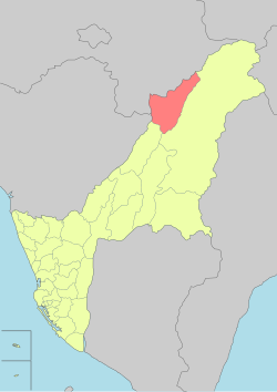
 Namaxia District in Kaohsiung City | |
| Country | Taiwan |
| Municipality | Kaohsiung City |
| Boroughs | List
|
| Government | |
| • Type | District government |
| • District chief | Dahu Istanda (Taiwan First National Party) |
| Population (January 2016) | |
• Total | 3,146 |

Namasia District (Tsou language: Namasia; Chinese: 那瑪夏區; Hanyu Pinyin: Nàmǎxià Qū; Tongyong Pinyin: Nàmǎsià Cyu; Wade–Giles: Na4-ma3-hsia4 Ch'ü1), formerly Sanmin Township (三民鄉; Sānmín Xiāng), is a mountain indigenous district located in the northeastern part of Kaohsiung, Taiwan. It is the second largest district in Kaohsiung after Tauyuan District.
Name
On January 1, 2008, the then-township (which then was a part of Kaohsiung County) was renamed from Sanmin to Namasia, as the name of Sanmin (taken from the Sun Yat-sen's Three Principles of the People), was considered an overly political name. Rather, the name Namasia was chosen, as it is the name of a local river in the Tsou language, while its meaning is "better and better" in the Bunun language. The population of the township is majority Bunun with a substantial Tsou and Kanakanavu minority.[2]
History
During the period of Japanese rule, Namaxia was grouped with Maolin District and Taoyuan District and classified as "Savage Land" (蕃地), which was governed under Kizan District of Takao Prefecture.
Geography
The district is mountainous and populated mainly by Taiwanese aborigines. Most residents are Christians.
The lowest point in the Qishan River valley is 430 meters above sea level; the highest is the peak of Mount Xinwangling (新望嶺), at 2,481 meters. The four main settlements upriver are Nangisalu (南沙魯), Maya (瑪雅), and Takanua (達卡努瓦) 1 & 2 .
There is plentiful wildlife: 29 mammal species, 97 bird species, 30 types of reptile, 16 amphibians, and 18 fishes. There are also 89 butterfly species.
Administrative divisions
Namasia District is divided into three urban villages:
- Nangisalu Village (南沙魯里)
- Maya Village (瑪雅里)
- Takanua Village (達卡努瓦里)[3]
| Namaxia District administrative divisions |
Politics
On 29 November 2014, Dahu Istanda of Taiwan First Nations Party[4] was elected the first ever District Magistrate of Namaxia.
See also
References
- ^ "Administrative Districts". 高雄市政府. 30 September 2016. Retrieved 4 April 2017.
- ^ "Yahoo奇摩新聞".
- ^ Web, Namaxia Township Office (2 December 2010). "Namaxia Township Office Web".
- ^ "UNPO: Taiwan: First Indigenous Political Party Founded".


