
Shodapur
This article has multiple issues. Please help improve it or discuss these issues on the talk page. (Learn how and when to remove these template messages)
|
| Shodapur | |
|---|---|
 | |
 Location of Shodapur in Haryana  Shodapur (India) | |
| General information | |
| Coordinates | 29°23′N 76°58′E / 29.39°N 76.97°E |
Shodapur is a village in Panipat district of the Haryana state in India. The Second Battle of Panipat was fought on 5 November 1556 between the forces of Akbar and Hemu, a Hindu king of Delhi.[1][2] In the battle, a wounded Hemu was captured by Shah Quli Khan and carried to the Mughal camp at Shodapur on Jind Road at Panipat where he was beheaded.[citation needed]
After a few years, Hemu's supporters, constructed a Samadhi (Hindu shrine) over the place where he was beheaded. The place and its surroundings have been slowly encroached upon by the local Muslim people who have converted it into a Muslim durgah. This is the only memorial of Hemu in Panipat but it is in a bad condition.
Gallery
-
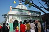 Hemu's Samadhi Sthal place beheading of Raja Hemu at village Shodapur
 -
 Smarat Hemu Bhargava - Victor of Twenty Two Pitched Battles
 -
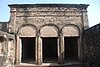 Portuguese colonial architecture in Hemu's Haveli in Rewari, which was renovated in 1540, when Hemu became 'Market Superintendent' in Delhi.
 -
 Agra Fort, won by Hemu in 1553, recaptured from Humayun in 1556, before capturing Delhi.
 -
 Gwalior Fort, from where Hemu launched most of the attacks during 1553–56, for his 22 battle victories.


See also
References
- ^ Richards, John F., ed. (1995) [1993]. The Mughal Empire. The New Cambridge History of India (7th ed.). Cambridge University Press. p. 13. ISBN 9780521566032. Retrieved 29 May 2013.
- ^ Kolff, Dirk H. A. (2002). Naukar, Rajput, and Sepoy: The Ethnohistory of the Military Labour Market of Hindustan, 1450-1850. Cambridge University Press. p. 163. ISBN 9780521523059. Retrieved 29 May 2013.
This Haryana location article is a stub. You can help Wikipedia by expanding it. |