Thiruthangal
Thiruthangal | |
|---|---|
Town | |
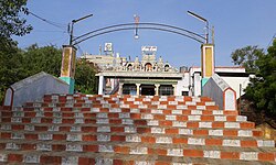
 Image of Ninra Narayana Perumal temple | |
 | |
| Country | India |
| State | Tamil Nadu |
| District | Virudhunagar |
| Government | |
| • Type | First Grade Municipality |
| • Body | Thiruthangal Municipality |
| Population (2011) | |
• Total | 55,362 |
| Languages | |
| • Official | Tamil |
| Time zone | UTC+5:30 (IST) |
| PIN | 626130 |
| Vehicle registration | TN67 |
Thiruthangal (திருத்தங்கல்) is a municipality in Virudhunagar district in the Indian state of Tamil Nadu. Ninra Narayana Perumal temple is also one among the 108 Divya Desams, Vishnu temples revered by saint poets, Alwars of 6th–9th century. It is 2 kilometres from the industrial town of Sivakasi, known for its printing, match-works and fireworks industries. Thiruthangal is well connected by bus and train and can be reached by air via Madurai. As of 2011, the town had a population of 55,362.
Demographics
According to 2011 census, Thiruthangal had a population of 55,343 with a sex-ratio of 1,000 females for every 1,000 males, much above the national average of 929.[1] A total of 5,918 were under the age of six, constituting 3,046 males and 2,872 females. Scheduled Castes and Scheduled Tribes accounted for 20.89% and .19% of the population respectively. The average literacy of the town was 71.89%, compared to the national average of 72.99%.[1] The town had a total of 15424 households. There were a total of 27,159 workers, comprising 59 cultivators, 226 main agricultural labourers, 1,284 in house hold industries, 23,722 other workers, 1,868 marginal workers, 6 marginal cultivators, 22 marginal agricultural labourers, 117 marginal workers in household industries and 1,723 other marginal workers.[2]
As per the religious census of 2011, Thiruthangal had 92.74% Hindus, 1.03% Muslims, 6.14% Christians, 0.01% Sikhs, and 0.08% following other religions.[3]
Economy
Thiruthangal is once a part of Sivakasi among the largest exporter of firecrackers all over the country and abroad. Historical Prime Minister Jawaharlal Nehru called "Kutti Japan.".[4] It also has granite quarries, namely Standard Granites and PRP Granites.
Thiruthangal is the hub for many villages surrounding it like Sukkiravarapatti, Sillayanaickenpatti, Alamarathupatti, Naranapuram, Sengamalapatti, Velliapuram, Anaikutam, Vadamallapuram, Erichanatham, M Pudupatti etc... The town has mono track broad gauge railway station. It will connect Chennai and Sengottai.
Thiruthangal is now added with a pyramid meditation hall under the name of Sitthar Arumuga Thambiran Pyramid Dhyana Beedam.
Panguni Pongal and Thai Poosam are celebrated every year. Sivan Temple and Perumal Temple are located at a same place.
Temple in Tiruthangal is one among 108 Divya desam The main deity is Nindra Narayana perumal in standing posture with his consort Chengkamala thayar in separate sanctum. Teertham is papavinasa teertham and vimanam Deva Chandra vimanam. Sridevi and Neeladevi are to the left and Bhoodevi and Jambavathi are to the right side of perumal. Markendeyar is seen in sitting posture to the right side. Brugu Maharishi, Anirudha and his wife Usha are seen inside the sanctum.
References
- ^ a b "Census Info 2011 Final population totals". Office of The Registrar General and Census Commissioner, Ministry of Home Affairs, Government of India. 2013. Retrieved 26 January 2014.
- ^ "Census Info 2011 Final population totals – Thiruthangal". Office of The Registrar General and Census Commissioner, Ministry of Home Affairs, Government of India. 2013. Retrieved 26 January 2014.
- ^ "Population By Religious Community - Tamil Nadu" (XLS). Office of The Registrar General and Census Commissioner, Ministry of Home Affairs, Government of India. 2011. Retrieved 13 September 2015.
- ^ Jain, Kajri (2007). Gods in the Bazaar: The Economies of Indian Calendar Art. Duke University Press. p. 39. ISBN 0-8223-3926-9. Retrieved 2008-06-18.
External links
9°28′33″N 77°47′33″E / 9.47583°N 77.79250°E

