Liuqiu Island
22°20′19.12″N 120°22′11.34″E / 22.3386444°N 120.3698167°E
Liuqiu Township | |
|---|---|
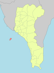
 Liuqiu Township in Pingtung County | |
 Satellite image of Xiaoliuqiu | |
| Country | Republic of China (Taiwan) |
| County | Pingtung County |
| Government | |
| • Township Chief | Chen Lung-chin |
| Area | |
| • Total | 6.8 km2 (2.6 sq mi) |
| Population (December 2014) | |
| • Total | 12,675 |
| • Density | 1,900/km2 (4,800/sq mi) |
| Website | http://liuqiu.pthg.gov.tw/liuqiu/web_en.php |
Xiaoliuqiu, Little Liuqiu (Chinese: 小琉球; pinyin: Xiǎo Liúqiú) or Lamay Island is an island belonging to Taiwan administered as Liuqiu Township[1] (琉球鄉; Liúqiú Xiāng) of Pingtung County. It has an area of 6.8 square kilometres (2.6 sq mi) and lies 15 kilometres (8.1 nmi) west of Donggang; it is Taiwan's only large coral island. The eight villages on the island are populated by approximately 13,000 residents with 10 shared surnames.
Etymology and names

Lamay (also Lambay or Lamey), formerly the most common English name for the island, is a name that most probably originates from a Taiwanese aboriginal language. Golden Lion Island is another historical English name for the island.[2][3] Two years prior to the beginning of Dutch rule in Taiwan, a Dutch ship named the Golden Lion (Early Modern Dutch: Gouden Leeuw) was wrecked on the coral reefs of the isle. After the Dutch took control of the island, they renamed it Gouden Leeuwseylant ("Golden Lion Island") as a memorial to the crew who were killed by the native inhabitants.[4]
In Chinese, Liúqiú originally referred to the island of Taiwan according to the History of Yuan. However, during the Ming dynasty the term came to mean Lamay Island. However, the same Chinese name also refers to the Ryukyu Islands between Taiwan and Japan. Thus, Xiao Liuqiu (Chinese: 小琉球; pinyin: Xiǎo Liúqiú; Wade–Giles: Hsiao3 Liu2-ch'iu2; Pe̍h-ōe-jī: Sió-liû-khiû; lit. 'Lesser Liuqiu'; Pha̍k-fa-sṳ: Séu Liù-khiù) has been commonly used since the Japanese era, although the island is officially Liuqiu Island (琉球嶼; Liúqiú Yǔ; Liu2-ch'iu2 Yü3; Liû-khiû-sū; Liù-khiù-yí). Variants of this name include Little Liuchiu, Hsiao Liuchiu and Liouciou.
During Japanese rule, the island was administered as Ryūkyū Village, Tōkō District, Takao Prefecture. After the Republic of China took control of Taiwan, the island was administrated under the name Liuqiu Township of Pingtung County, the only island township of the county.
Geography

Located at the southwest coast of Taiwan, Xiaoliuqiu is bordered by the Taiwan Strait to the west and the South China Sea to the South. It is one of Taiwan's largest coral islands and the only one with significant population and human activities. There are no rivers so farming is very difficult. Most residents make their living by fishing. In recent years the island has become noted for cage aquaculture.
Climate
Xiaoliuqiu has a tropical monsoon climate, with warm temperatures year round with a rainy season from April to October and a dry season with cooler temperatures from November to March of the following year. The sea temperature of the island is above 25 degrees Celsius year round, making it one of the best locations for swimming activities during the winter in Taiwan, as well as allowing up to thousands of species of coral reefs to inhabit the area.
| Climate data for Liuqiu Township | |||||||||||||
|---|---|---|---|---|---|---|---|---|---|---|---|---|---|
| Month | Jan | Feb | Mar | Apr | May | Jun | Jul | Aug | Sep | Oct | Nov | Dec | Year |
| Mean daily maximum °C (°F) | 25.1 (77.2) |
25.7 (78.3) |
27.5 (81.5) |
29.5 (85.1) |
31.3 (88.3) |
31.7 (89.1) |
32.2 (90.0) |
32.0 (89.6) |
31.3 (88.3) |
30.2 (86.4) |
27.8 (82.0) |
25.5 (77.9) |
29.2 (84.5) |
| Mean daily minimum °C (°F) | 18.0 (64.4) |
18.5 (65.3) |
19.8 (67.6) |
22.2 (72.0) |
24.3 (75.7) |
25.5 (77.9) |
25.8 (78.4) |
25.5 (77.9) |
25.0 (77.0) |
24.1 (75.4) |
21.8 (71.2) |
18.8 (65.8) |
22.4 (72.4) |
| Average rainfall mm (inches) | 16.0 (0.63) |
20.5 (0.81) |
38.8 (1.53) |
69.8 (2.75) |
197.4 (7.77) |
415.3 (16.35) |
390.9 (15.39) |
416.7 (16.41) |
241.9 (9.52) |
42.7 (1.68) |
18.7 (0.74) |
16.2 (0.64) |
1,884.9 (74.22) |
| Average relative humidity (%) | 75 | 76 | 75 | 77 | 78 | 81 | 80 | 81 | 79 | 76 | 75 | 74 | 77 |
| Mean monthly sunshine hours | 175 | 167 | 190 | 192 | 200 | 201 | 225 | 196 | 175 | 184 | 167 | 163 | 2,235 |
| Source 1: Wunderground [5] | |||||||||||||
| Source 2: Central Weather Bureau (Rainfall data of Kaohsiung City is shown for reference due to the island's proximity to Kaohsiung)[6] | |||||||||||||
| Jan | Feb | Mar | Apr | May | Jun | Jul | Aug | Sep | Oct | Nov | Dec | Year |
|---|---|---|---|---|---|---|---|---|---|---|---|---|
| 25.0 °C (77.0 °F) | 25.2 °C (77.4 °F) | 25.7 °C (78.3 °F) | 26.9 °C (80.4 °F) | 28.1 °C (82.6 °F) | 29.1 °C (84.4 °F) | 29.4 °C (84.9 °F) | 29.2 °C (84.6 °F) | 28.8 °C (83.8 °F) | 28.1 °C (82.6 °F) | 27.0 °C (80.6 °F) | 25.8 °C (78.4 °F) | 27.4 °C (81.3 °F) |
Tourism


Efforts for planned development received a boost after Xiaoliuqiu was included in the Dapeng Bay National Scenic Area in 2004. Tourism gradually got popular mainly since the late 2000s, with increasing media exposure and advertisements. There are hundreds B&Bs or hotels on the island providing service for the tourists, many of which includes packages such as bicycle and motorcycle renting and scuba diving. According to Pingtung county's statistics of tourism, the number of visitors to Xiaoliuqiu reached 400,000 per year in 2014,[7][8] a relatively large amount for an island that is only 6.8 km² in size.
Some of the best-known local sights include Black Dwarf Cave, Beauty Cave, Houshih Rock Formations, and Venice Beach.
Xiaoliuqiu is a popular tourist destination and is well known for its ghost stories and rumors of haunted caves. The most famous is Black Dwarf Cave. Carved on the entrance of the cave is this story:
It was in 1661 (the 15th year of the Yong Li Ming Dynasty) national hero Koxinga (Cheng Chen-kung, 鄭成功), knighted as Yen Ping King, drove the Dutch and restored Taiwan and the Pescadores (Penghu). During the Dutch escape, some Negroes were separated from their unit and arrived at this island. They lived in this cave. Some years later, a British boat with soldiers landed at the place northeast of the cave. As they were enjoying the scenery, those Negroes robbed their food and other things, burned the boat and killed all the British. It was discovered by the British warship that they landed this island and sought the murderers while the Negroes hid in the cave. In spite of many threats, they refused to surrender. Finally, the British burned the cave with oil. Then, all the Negroes died there in the cave. Later it was named as the Black Spirit Cave, which means the cave in which the foreign Negroes had lived before.[9]
Many have doubted the accuracy of this story and have instead related the "Negroes" to members of the local Siraya tribe, who were massacred in the Lamey Island Massacre.[9]
Beauty Cave has a tragic legend attached to its history. The cave is named after the young daughter of a Ming loyalist who was exiled from China by the Manchus. According to legend, the loyalist lived with his daughter in the cave, surviving on plants and small fish. When the father eventually died, his daughter was so stricken with grief that she bit her own tongue off and died.
List of scenic spots
- Baisha Port
- Beauty Cave
- Black Dwarf Cave
- Dafu Port
- Liuchiu Yu Lighthouse
- Lobster Cave
- Vase Rock
- Sea View Pavilion (望海亭)
- Duozaiping (肚仔坪)
- SanFu Port (杉福漁港)
- Wild Boar Ditch (山豬溝)
- Sanfu Ecological Path (生態廊道)
- Geban Bay (蛤板灣)
- Sunset Galley (落日亭)
- HaiTzuKuo (海子口)
- Wetland Part (濕地公園)
- Biyun Temple (碧雲寺)
- Sanlung Temple (三隆宮)
- Lingshan Temple (靈山寺)
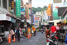
- Sanmin Road (三民老街)
- ChungAu Beach (中澳沙灘)
- Restoration Pavilion (復育涼亭)
- Houshi Fringing Reef (厚石裙礁)
- Mouse Rock (老鼠石)
- Guanyin Rock (觀音石)
- Indian Rock (紅蕃石)
- Climbing Tiger Rock (爬山虎)
Administrative divisions


Liuqiu Township consists of 8 villages, while Zhongfu Village is the administrative center of the township.
| Liuqiu Township Administrative Divisions |
Transportation
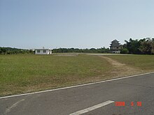
The only transportation to Xiaoliuqiu is by ship from Donggang in mainland Pingtung County arriving at Dafu Port on the island.[10] Although there is an airport that once had passenger service with direct flights between Kaohsiung international airport and the island, it is now used for helicopter only. The island is 8-9 nautical miles from the Taiwan mainland, which is about a 25- to 30-minute boat ride.
Education
The island only provides education from primary to junior high school. Senior high school and university students need to attend schools on the Taiwanese mainland.
Primary School
- Pingtung Baisha Primary School
- Pingtung Liuqiu Primary School
- Pingtung Tiannan Primary School
- Pingtung Quande Elementary School
Junior High School
Temples
Xiaoliuqiu is famous for its 38 temples[11]—six per square kilometer. The most important temple on the island is Piyun Temple, dedicated to Guanyin, the Buddhist Bodhisattva of Mercy. On Guanyin's birthday, the nineteenth day of the second lunar month, a festival is held in Piyun Temple.
Taiwanese opera troupes perform twice a day in front of the major temples for 40 to 50 days.[vague]
Wildlife
Xiaoliuqiu is well known for its diverse ecosystem. Chung Au Beach, a popular tourist destination, is a shell sand beach abutting waters that are home to approximately 176 species of fish and numerous coral species. It is also home to sub-adult and adult green sea turtles, with adult females coming ashore to nest during the summer months. Marine vertebrates such as sharks, flying fish, sea turtles, and cetaceans such as sperm whales may appear around the island.[12]
Notable natives
- Lee Shu-chuan, Secretary-General of Kuomintang
See also
- List of islands of the Republic of China
- List of islands of Taiwan
- List of islands in the East China Sea
- Lamey Island Massacre
References
- ^ 臺灣地區鄉鎮市區級以上行政區域名稱中英對照表 Archived March 25, 2012, at the Wayback Machine Glossary of Names for Administrative Divisions. Template:Zh icon Accessed at Taiwan Geographic Names Information System website Archived August 16, 2013, at the Wayback Machine Template:En icon. Ministry of the Interior. 16 June 2011. Retrieved 5 September 2015.
- ^ Black Ghost Cave Incident
- ^ Campbell, William (1903). "Explanatory Notes". Formosa under the Dutch: described from contemporary records, with explanatory notes and a bibliography of the island. London: Kegan Paul. p. 542. OCLC 644323041.
{{cite book}}: External link in|chapterurl=|ref=harv(help); Unknown parameter|chapterurl=ignored (|chapter-url=suggested) (help) - ^ Blussé, Leonard (2000). "The Cave of the Black Spirits". In Blundell, David (ed.). Austronesian Taiwan. California: University of California. ISBN 0-936127-09-0.
- ^ "Climate". Wunderground.
- ^ "Climate". Central Weather Bureau.
- ^ http://news.pts.org.tw/detail.php?NEENO=237275
- ^ http://www.chinapost.com.tw/taiwan/local/pingtung/2015/04/11/433361/Garbage-reported.htm
- ^ a b Momphard, David (2004-07-18). "Of grottoes and graves". Taipei Times. Retrieved 2008-09-05.
- ^ http://focustaiwan.tw/news/asoc/201508100028.aspx
- ^ di Genova, Trista (10 July 2008). "Hsiao Liuchiu: Unknown paradise on the sea". The China Post. Retrieved 9 August 2012.
- ^ 幸運!搭交通船到小琉球遇見「鯨」喜
External links
- Tapeng Bay National Scenic Area Template:Zh icon
- Liuqiu Township Office Template:Zh icon
- Liuqiu official tourism website Template:En icon


