
Marina del Rey, California: Difference between revisions
. |
|||
| Line 14: | Line 14: | ||
|mapsize1= |
|mapsize1= |
||
|map_caption1= |
|map_caption1= |
||
|subdivision_type = |
|subdivision_type =[[List of countries|Country]] |
||
|subdivision_name = |
|subdivision_name ={{USA}} |
||
|subdivision_type1 = |
|subdivision_type1 =[[Political divisions of the United States|State]] |
||
|subdivision_name1 = |
|subdivision_name1 ={{flag|California}} |
||
|subdivision_type2 = |
|subdivision_type2 =[[List of counties in California|County]] |
||
|subdivision_name2=[[Los Angeles County, California|Los Angeles]] |
|subdivision_name2=[[Los Angeles County, California|Los Angeles]] |
||
|government_footnotes= |
|government_footnotes= |
||
| Line 28: | Line 28: | ||
|established_title= |
|established_title= |
||
|established_date= |
|established_date= |
||
<!-- Area------------------> |
|||
|area_magnitude = |
|area_magnitude = |
||
| |
|unit_pref =US |
||
| |
|area_footnotes = <ref>[http://www.census.gov/geo/www/gazetteer/files/Gaz_places_national.txt U.S. Census]</ref> |
||
| |
|area_total_sq_mi = 1.455 |
||
| |
|area_land_sq_mi = 0.860 |
||
| |
|area_water_sq_mi = 0.595 |
||
| |
|area_total_km2 = 3.768 |
||
| |
|area_land_km2 = 2.226 |
||
| |
|area_water_km2 = 1.541 |
||
| |
|area_water_percent = 40.91 |
||
| |
|area_note = |
||
|population_as_of=2010 |
|population_as_of=2010 |
||
|population_footnotes= |
|population_footnotes= |
||
| Line 67: | Line 65: | ||
|footnotes= |
|footnotes= |
||
}} |
}} |
||
'''Marina del Rey''' is an affluent [[unincorporated area|unincorporated]] seaside community and [[census-designated place]] (CDP) in [[Los Angeles County, |
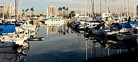
'''Marina del Rey''' is an affluent [[unincorporated area|unincorporated]] seaside community and [[census-designated place]] (CDP) in [[Los Angeles County, California]]. A [[Westside (Los Angeles County)|Westside]] locale, the population was 8,866 at the 2010 census. [[Fisherman's Village]] offers a view of Marina del Rey's dominant feature, the Marina, the world's largest man-made small craft harbor with 19 marinas with capacity for 5,300 boats and is home port to approximately 6,500 boats. The harbor, the ''[[Los Angeles Times]]'' said in 1997, is "perhaps the county's most valuable resource".<ref>{{cite news |title=Welcome Wave at the Marina |work=[[Los Angeles Times]] |date=April 17, 1997 |department=Editorial |url=http://articles.latimes.com/1997-04-17/local/me-49585_1_marina-development}}</ref> |
||
==History== |
==History== |
||
Prior to its development as a small craft harbor, the land occupied by Marina del Rey was a [[salt-marsh]] fed by fresh water from [[Ballona Creek]], frequented by duck hunters and few others. Burton W. Chace, a member of the Los Angeles County Board of Supervisors, referred to the area as [[mud flats]], though today the area would more properly be referred to as [[wetlands]]. |
Prior to its development as a small craft harbor, the land occupied by Marina del Rey was a [[salt-marsh]] fed by fresh water from [[Ballona Creek]], frequented by duck hunters and few others. Burton W. Chace, a member of the Los Angeles County Board of Supervisors, referred to the area as [[mud flats]], though today the area would more properly be referred to as [[wetlands]]. |
||
In the mid-19th century, M.C. Wicks thought of turning this Playa del Rey estuary into a commercial port. |
In the mid-19th century, M.C. Wicks thought of turning this Playa del Rey estuary into a commercial port. He formed the Ballona Development Company in 1888 to develop the area, but three years later the company went bankrupt. |
||
In 1916, the [[U.S. Army Corps of Engineers]] revisited the idea of a commercial harbor, but declared it economically impractical. In 1936 the [[U.S. Congress]] ordered a re-evaluation of that determination, and the Army Corps of Engineers returned with a more favorable determination; however, the Marina del Rey harbor concept lost out to San Pedro as a commercial harbor and development funding went to the [[Port of Los Angeles]] instead. |
In 1916, the [[U.S. Army Corps of Engineers]] revisited the idea of a commercial harbor, but declared it economically impractical. In 1936 the [[U.S. Congress]] ordered a re-evaluation of that determination, and the Army Corps of Engineers returned with a more favorable determination; however, the Marina del Rey harbor concept lost out to San Pedro as a commercial harbor and development funding went to the [[Port of Los Angeles]] instead. |
||
| Line 100: | Line 98: | ||
==Adjacent neighborhoods== |
==Adjacent neighborhoods== |
||
{{Geographic Location 2 |
{{Geographic Location 2 |
||
|Center = Marina del Rey |
|||
|Northwest = [[Venice, Los Angeles, California|Venice]] |
|||
|North = [[Venice, Los Angeles, California|Venice]] |
|||
|Northeast = [[Mar Vista]] &<br>[[Culver City, California|Culver City]] |
|||
|East = [[Sunkist Park, Culver City, California|Sunkist Park]] |
|||
|ESE = |
|||
|Southeast = [[Westchester, Los Angeles, California|Westchester]] |
|||
|South = [[Playa del Rey, Los Angeles|Playa del Rey]] |
|||
|Southwest = [[Dockweiler State Beach]]—<br>[[Pacific Ocean]] |
|||
|WSW = |
|||
|West = [[Santa Monica Bay]]—<br>[[Pacific Ocean]] |
|||
|WNW = |
|||
}} |
}} |
||
===Climate=== |
===Climate=== |
||
{{Weather box |
{{Weather box |
||
|location = Marina del Rey, California |
|location = Marina del Rey, California |
||
| Line 158: | Line 155: | ||
|Dec precipitation inch = 1.90 |
|Dec precipitation inch = 1.90 |
||
|year precipitation inch = 13.32 |
|year precipitation inch = 13.32 |
||
|source 1 = IDcide<ref name= "Wakefield Climate Information">{{cite web |
|source 1 = IDcide<ref name= "Wakefield Climate Information">{{cite web|url=http://www.idcide.com/weather/ca/marina-del-rey.htm|title= Marina del Rey, CA Normal Temperatures and Precipitation|accessdate=Jan 15, 2011}}</ref> |
||
| url = http://www.idcide.com/weather/ca/marina-del-rey.htm| title = Marina del Rey, CA Normal Temperatures and Precipitation | accessdate = Jan 15, 2011}}</ref> |
|||
|date=January 2011 |
|date=January 2011 |
||
}} |
}} |
||
| Line 169: | Line 165: | ||
| 2000=8176 |
| 2000=8176 |
||
| 2010=8866 |
| 2010=8866 |
||
| ⚫ | |footnote= sources:<ref>{{cite web|url=http://www.census.gov/prod/www/abs/decennial/index.html|title=CENSUS OF POPULATION AND HOUSING (1790-2000)|publisher=[[U.S. Census Bureau]]|accessdate=2010-07-17}}</ref><ref>http://factfinder2.census.gov/faces/tableservices/jsf/pages/productview.xhtml?pid=DEC_10_PL_GCTPL1.ST13&prodType=table US Census Bureau</ref> |
||
| footnote= sources:<ref>{{cite web |
|||
|url=http://www.census.gov/prod/www/abs/decennial/index.html |
|||
|title=CENSUS OF POPULATION AND HOUSING (1790-2000) |
|||
|publisher=[[U.S. Census Bureau]] |
|||
| ⚫ | |||
}} |
}} |
||
===2010=== |
===2010=== |
||
The [[2010 United States Census]]<ref>{{USCensus-2010CA}}</ref> reported that Marina del Rey had a population of 8,866. The [[population density]] was 6,094.6 people per square mile (2,353.1/km²). The racial makeup of Marina del Rey was 7,071 (79.8%) [[White (U.S. Census)|White]] (74.7% Non-Hispanic White),<ref>{{cite web|url=http://quickfacts.census.gov/qfd/states/06/0645806.html}}</ref> 465 (5.2%) [[African American (U.S. Census)|African American]], 31 (0.3%) [[Native American (U.S. Census)|Native American]], 749 (8.4%) [[Asian (U.S. Census)|Asian]], 10 (0.1%) [[Pacific Islander (U.S. Census)|Pacific Islander]], 154 (1.7%) from [[Race (United States Census)|other races]], and 386 (4.4%) from two or more races. |
The [[2010 United States Census]]<ref>{{USCensus-2010CA}}</ref> reported that Marina del Rey had a population of 8,866. The [[population density]] was 6,094.6 people per square mile (2,353.1/km²). The racial makeup of Marina del Rey was 7,071 (79.8%) [[White (U.S. Census)|White]] (74.7% Non-Hispanic White),<ref>{{cite web|url=http://quickfacts.census.gov/qfd/states/06/0645806.html}}</ref> 465 (5.2%) [[African American (U.S. Census)|African American]], 31 (0.3%) [[Native American (U.S. Census)|Native American]], 749 (8.4%) [[Asian (U.S. Census)|Asian]], 10 (0.1%) [[Pacific Islander (U.S. Census)|Pacific Islander]], 154 (1.7%) from [[Race (United States Census)|other races]], and 386 (4.4%) from two or more races. [[Hispanic (U.S. Census)|Hispanic]] or [[Latino (U.S. Census)|Latino]] of any race were 686 persons (7.7%). |
||
The Census reported that 8,860 people (99.9% of the population) lived in households, 6 (0.1%) lived in non-institutionalized group quarters, and 0 (0%) were institutionalized. |
The Census reported that 8,860 people (99.9% of the population) lived in households, 6 (0.1%) lived in non-institutionalized group quarters, and 0 (0%) were institutionalized. |
||
| Line 183: | Line 175: | ||
There were 5,600 households, out of which 429 (7.7%) had children under the age of 18 living in them, 1,317 (23.5%) were [[marriage|opposite-sex married couples]] living together, 215 (3.8%) had a female householder with no husband present, 126 (2.3%) had a male householder with no wife present. There were 541 (9.7%) [[POSSLQ|unmarried opposite-sex partnerships]], and 45 (0.8%) [[same-sex partnerships|same-sex married couples or partnerships]]. Of the households, 3,037 (54.2%) were made up of individuals and 601 (10.7%) had someone living alone who was 65 years of age or older. The average household size was 1.58. There were 1,658 [[family (U.S. Census)|families]] (29.6% of all households); the average family size was 2.32. |
There were 5,600 households, out of which 429 (7.7%) had children under the age of 18 living in them, 1,317 (23.5%) were [[marriage|opposite-sex married couples]] living together, 215 (3.8%) had a female householder with no husband present, 126 (2.3%) had a male householder with no wife present. There were 541 (9.7%) [[POSSLQ|unmarried opposite-sex partnerships]], and 45 (0.8%) [[same-sex partnerships|same-sex married couples or partnerships]]. Of the households, 3,037 (54.2%) were made up of individuals and 601 (10.7%) had someone living alone who was 65 years of age or older. The average household size was 1.58. There were 1,658 [[family (U.S. Census)|families]] (29.6% of all households); the average family size was 2.32. |
||
The population was spread out with 565 people (6.4%) under the age of 18, 487 people (5.5%) aged 18 to 24, 4,150 people (46.8%) aged 25 to 44, 2,473 people (27.9%) aged 45 to 64, and 1,191 people (13.4%) who were 65 years of age or older. |
The population was spread out with 565 people (6.4%) under the age of 18, 487 people (5.5%) aged 18 to 24, 4,150 people (46.8%) aged 25 to 44, 2,473 people (27.9%) aged 45 to 64, and 1,191 people (13.4%) who were 65 years of age or older. The median age was 40.0 years. For every 100 females there were 103.5 males. For every 100 females age 18 and over, there were 103.9 males. |
||
There were 6,742 housing units at an average density of 4,634.5 per square mile (1,789.4/km²), of which 644 (11.5%) were owner-occupied, and 4,956 (88.5%) were occupied by renters. The homeowner vacancy rate was 0.5%; the rental vacancy rate was 11.4%. |
There were 6,742 housing units at an average density of 4,634.5 per square mile (1,789.4/km²), of which 644 (11.5%) were owner-occupied, and 4,956 (88.5%) were occupied by renters. The homeowner vacancy rate was 0.5%; the rental vacancy rate was 11.4%. 936 people (10.6% of the population) lived in owner-occupied housing units and 7,924 people (89.4%) lived in rental housing units. |
||
According to the 2010 United States Census, Marina del Rey had a median household income of $89,673, with 10.7% of the population living below the federal poverty line.<ref>{{cite web|url=http://quickfacts.census.gov/qfd/states/06/0645806.html}}</ref> |
According to the 2010 United States Census, Marina del Rey had a median household income of $89,673, with 10.7% of the population living below the federal poverty line.<ref>{{cite web|url=http://quickfacts.census.gov/qfd/states/06/0645806.html}}</ref> |
||
| Line 201: | Line 193: | ||
[[File:Marina del Rey panorama.jpg|thumb|center|550px|Panoramic view of the marina from a nearby office building]] |
[[File:Marina del Rey panorama.jpg|thumb|center|550px|Panoramic view of the marina from a nearby office building]] |
||
* |
*[[Fisherman's Village]] |
||
* |
*[[Chace Park]]—the Marina del Rey Summer Concert Series is held here on Thursdays and Saturdays from June to August. |
||
* |
*California Yacht Club |
||
* |
*[[UCLA Marina Aquatic Center]] |
||
* |
*[[Ballona Wetlands]] |
||
* |
*Lloyd Taber Marina del Rey Library |
||
=== Parks and recreation === |
=== Parks and recreation === |
||
Marina de Rey has two main parks: [[Chace Park]]<ref>"[http://beaches.co.la.ca.us/BandH/Marina/chacepark.htm Burton W. Chase Park]". County of Los Angeles. Retrieved on March 22, 2010.</ref> and Yvonne B. Burke Park, renamed from the original Admiralty Park in 2009 to honor long-time [[Los Angeles County Supervisor]] [[Yvonne Brathwaite Burke]].<ref>"[http://beaches.co.la.ca.us/bandh/Marina/AdmiraltyPark.htm Yvonne B. Burke Park]". County of Los Angeles. Retrieved on March 22, 2010.</ref> |
Marina de Rey has two main parks: [[Chace Park]]<ref>"[http://beaches.co.la.ca.us/BandH/Marina/chacepark.htm Burton W. Chase Park]". County of Los Angeles. Retrieved on March 22, 2010.</ref> and Yvonne B. Burke Park, renamed from the original Admiralty Park in 2009 to honor long-time [[Los Angeles County Supervisor]] [[Yvonne Brathwaite Burke]].<ref>"[http://beaches.co.la.ca.us/bandh/Marina/AdmiraltyPark.htm Yvonne B. Burke Park]". County of Los Angeles. Retrieved on March 22, 2010.</ref> |
||
| Line 223: | Line 214: | ||
===Street layout=== |
===Street layout=== |
||
The harbor has eight basins separated by six strips of land, each of which has at least one street on it. From the northeastern end of the Marina, going clockwise, these streets are: Bali Way, Mindanao Way (with west terminus at [[Burton Chace Park]]), Fiji Way (bordering the southeastern edge of the Marina), Bora Bora Way, Tahiti Way, Marquesas Way, Panay Way, and Palawan Way. |
The harbor has eight basins separated by six strips of land, each of which has at least one street on it. From the northeastern end of the Marina, going clockwise, these streets are: Bali Way, Mindanao Way (with west terminus at [[Burton Chace Park]]), Fiji Way (bordering the southeastern edge of the Marina), Bora Bora Way, Tahiti Way, Marquesas Way, Panay Way, and Palawan Way. Panay Way, Marquesas Way, Tahiti Way, and Bora Bora Way are all on the western side of the Marina and all terminate at Via Marina. Palawan Way is also on the west side, but it terminates at [[Washington Boulevard (Los Angeles)|Washington Bl.]] |
||
[[Washington Boulevard (Los Angeles)|Washington Boulevard]] bounds the Marina to the northwest. |
[[Washington Boulevard (Los Angeles)|Washington Boulevard]] bounds the Marina to the northwest. Palawan Way and Via Marina end to the north at Washington Blvd. |
||
== Government and infrastructure == |
== Government and infrastructure == |
||
Revision as of 04:28, 15 May 2014
Marina del Rey | |
|---|---|
 Aerial view of Marina del Rey, with Los Angeles International Airport and Palos Verdes Peninsula in the background. | |
 Location of Marina del Rey in Los Angeles County, California and of Los Angeles County, California within California. | |
| Country | |
| State | |
| County | Los Angeles |
| Area | |
| • Total | 1.455 sq mi (3.768 km2) |
| • Land | 0.860 sq mi (2.226 km2) |
| • Water | 0.595 sq mi (1.541 km2) 40.91% |
| Elevation | 16 ft (5 m) |
| Population (2010) | |
| • Total | 8,866 |
| • Density | 6,100/sq mi (2,400/km2) |
| Time zone | UTC-8 (Pacific (PST)) |
| • Summer (DST) | UTC-7 (PDT) |
| ZIP codes | 90291–90292, 90295 |
| Area code(s) | 310, 424 |
| FIPS code | 06-45806 |
| GNIS feature ID | 1852255 |
Marina del Rey is an affluent unincorporated seaside community and census-designated place (CDP) in Los Angeles County, California. A Westside locale, the population was 8,866 at the 2010 census. Fisherman's Village offers a view of Marina del Rey's dominant feature, the Marina, the world's largest man-made small craft harbor with 19 marinas with capacity for 5,300 boats and is home port to approximately 6,500 boats. The harbor, the Los Angeles Times said in 1997, is "perhaps the county's most valuable resource".[2]
History
Prior to its development as a small craft harbor, the land occupied by Marina del Rey was a salt-marsh fed by fresh water from Ballona Creek, frequented by duck hunters and few others. Burton W. Chace, a member of the Los Angeles County Board of Supervisors, referred to the area as mud flats, though today the area would more properly be referred to as wetlands.
In the mid-19th century, M.C. Wicks thought of turning this Playa del Rey estuary into a commercial port. He formed the Ballona Development Company in 1888 to develop the area, but three years later the company went bankrupt.
In 1916, the U.S. Army Corps of Engineers revisited the idea of a commercial harbor, but declared it economically impractical. In 1936 the U.S. Congress ordered a re-evaluation of that determination, and the Army Corps of Engineers returned with a more favorable determination; however, the Marina del Rey harbor concept lost out to San Pedro as a commercial harbor and development funding went to the Port of Los Angeles instead.

In 1953, the Los Angeles County Board of Supervisors authorized a $2 million loan to fund construction of the marina. Since the loan only covered about half the cost, the U.S. Congress passed and President Dwight D. Eisenhower signed Public Law 780 making construction possible. Ground breaking began shortly after.
With construction almost complete, the marina was put in danger in 1962–1963 due to a winter storm. The storm caused millions of dollars in damage to both the marina and the few small boats anchored there. A plan was put into effect to build a breakwater at the mouth of the marina, and the L.A. County Board of Supervisors appropriated $2.1 million to build it. On April 10, 1965 Marina del Rey was formally dedicated. The total cost of the marina was $36.25 million for land, construction, and initial operation.
Geography
Marina del Rey falls within unincorporated Los Angeles County and is southeast of the L.A. City community of Venice and north of the L.A. City community of Playa del Rey, near the mouth of Ballona Creek. It is located four miles (6 km) north of Los Angeles International Airport.
It is bounded on all sides by the City of Los Angeles. The beach-style homes, the strip of land against the beach, and the beach itself (see photo), west of the harbor, are within the City of Los Angeles limits, but share the same zip code as Marina del Rey. The name of this strip is the Marina Peninsula. Via Dolce and the southern portion of Via Marina are the boundaries between L.A. City and the unincorporated area.
According to the United States Census Bureau, Marina del Rey has an area of 1.5 square miles (3.9 km2). Nine-tenths of a square mile (2.2 km²) is land and 0.6 square miles (1.6 km2) is water (40.91%).
The marina itself, a specially designed harbor with moorings for pleasure craft and small boats, is surrounded by high-rise condos, hotels, apartments, shops, and restaurants. The area also includes the University of Southern California Information Sciences Institute and the UCLA Marina Aquatic Center.
The community is served by the three-mile-long (5 km) Marina Freeway (State Route 90), which links Marina del Rey directly to Interstate 405 and nearby Culver City.
Marina del Rey is in area code 310 & 424. Its ZIP code is 90292.
-
 The marina from which Marina del Rey takes its name.
 -
 Looking northeast from the South Jetty area of Marina del Rey on September 11, 2011.


Adjacent neighborhoods
Places adjacent to Marina del Rey, California | |
|---|---|
Climate
| Climate data for Marina del Rey, California | |||||||||||||
|---|---|---|---|---|---|---|---|---|---|---|---|---|---|
| Month | Jan | Feb | Mar | Apr | May | Jun | Jul | Aug | Sep | Oct | Nov | Dec | Year |
| Mean daily maximum °F (°C) | 67 (19) |
68 (20) |
69 (21) |
72 (22) |
73 (23) |
77 (25) |
80 (27) |
81 (27) |
80 (27) |
77 (25) |
71 (22) |
67 (19) |
74 (23) |
| Mean daily minimum °F (°C) | 46 (8) |
47 (8) |
49 (9) |
52 (11) |
55 (13) |
58 (14) |
61 (16) |
62 (17) |
61 (16) |
57 (14) |
50 (10) |
46 (8) |
54 (12) |
| Average precipitation inches (mm) | 3.19 (81) |
3.25 (83) |
2.66 (68) |
0.58 (15) |
0.26 (6.6) |
0.04 (1.0) |
0.02 (0.51) |
0.07 (1.8) |
0.08 (2.0) |
0.33 (8.4) |
0.94 (24) |
1.90 (48) |
13.32 (338) |
| Source: IDcide[3] | |||||||||||||
Demographics
| Census | Pop. | Note | %± |
|---|---|---|---|
| 1980 | 8,065 | — | |
| 1990 | 7,431 | −7.9% | |
| 2000 | 8,176 | 10.0% | |
| 2010 | 8,866 | 8.4% | |
| sources:[4][5] | |||
2010
The 2010 United States Census[6] reported that Marina del Rey had a population of 8,866. The population density was 6,094.6 people per square mile (2,353.1/km²). The racial makeup of Marina del Rey was 7,071 (79.8%) White (74.7% Non-Hispanic White),[7] 465 (5.2%) African American, 31 (0.3%) Native American, 749 (8.4%) Asian, 10 (0.1%) Pacific Islander, 154 (1.7%) from other races, and 386 (4.4%) from two or more races. Hispanic or Latino of any race were 686 persons (7.7%).
The Census reported that 8,860 people (99.9% of the population) lived in households, 6 (0.1%) lived in non-institutionalized group quarters, and 0 (0%) were institutionalized.
There were 5,600 households, out of which 429 (7.7%) had children under the age of 18 living in them, 1,317 (23.5%) were opposite-sex married couples living together, 215 (3.8%) had a female householder with no husband present, 126 (2.3%) had a male householder with no wife present. There were 541 (9.7%) unmarried opposite-sex partnerships, and 45 (0.8%) same-sex married couples or partnerships. Of the households, 3,037 (54.2%) were made up of individuals and 601 (10.7%) had someone living alone who was 65 years of age or older. The average household size was 1.58. There were 1,658 families (29.6% of all households); the average family size was 2.32.
The population was spread out with 565 people (6.4%) under the age of 18, 487 people (5.5%) aged 18 to 24, 4,150 people (46.8%) aged 25 to 44, 2,473 people (27.9%) aged 45 to 64, and 1,191 people (13.4%) who were 65 years of age or older. The median age was 40.0 years. For every 100 females there were 103.5 males. For every 100 females age 18 and over, there were 103.9 males.
There were 6,742 housing units at an average density of 4,634.5 per square mile (1,789.4/km²), of which 644 (11.5%) were owner-occupied, and 4,956 (88.5%) were occupied by renters. The homeowner vacancy rate was 0.5%; the rental vacancy rate was 11.4%. 936 people (10.6% of the population) lived in owner-occupied housing units and 7,924 people (89.4%) lived in rental housing units.
According to the 2010 United States Census, Marina del Rey had a median household income of $89,673, with 10.7% of the population living below the federal poverty line.[8]
2000
As of the censusTemplate:GR of 2000, there were 8,176 people, 5,315 households, and 1,520 families residing in the Census Designated Place (CDP). The population density was 9,289.5 inhabitants per square mile (3,587.2/km²). There were 6,321 housing units at an average density of 7,181.8 per square mile (2,773.4/km²). The racial makeup of the CDP was 82.46% White, 4.68% African American, 0.16% Native American, 8.21% Asian, 0.16% Pacific Islander, 1.30% from other races, and 3.03% from two or more races. Hispanic or Latino of any race were 5.34% of the population.
There were 5,315 households out of which 6.7% had children under the age of 18 living with them, 22.7% were married couples living together, 3.6% had a female householder with no husband present, and 71.4% were non-families. Of all households, 57.3% were made up of individuals and 6.8% had someone living alone who was 65 years of age or older. The average household size was 1.54 and the average family size was 2.31.
In the CDP the population was spread out with 6.4% under the age of 18, 5.1% from 18 to 24, 50.4% from 25 to 44, 28.2% from 45 to 64, and 10.0% who were 65 years of age or older. The median age was 39 years. For every 100 females there were 108.8 males. For every 100 females age 18 and over, there were 108.6 males.
The median income for a household in the CDP was $68,447, and the median income for a family was $84,390. Males had a median income of $66,928 versus $51,854 for females. The per capita income for the CDP was $58,530. About 6.5% of families and 8.8% of the population were below the poverty line, including 9.6% of those under age 18 and 6.2% of those age 65 or over.
Points of interest

- Fisherman's Village
- Chace Park—the Marina del Rey Summer Concert Series is held here on Thursdays and Saturdays from June to August.
- California Yacht Club
- UCLA Marina Aquatic Center
- Ballona Wetlands
- Lloyd Taber Marina del Rey Library
Parks and recreation
Marina de Rey has two main parks: Chace Park[9] and Yvonne B. Burke Park, renamed from the original Admiralty Park in 2009 to honor long-time Los Angeles County Supervisor Yvonne Brathwaite Burke.[10]
Economy
The following organizations are headquartered in Marina del Rey:
Transportation
The Marina Expressway, California State Route 90, terminates at Lincoln Blvd (California State Route 1) in northeastern Marina del Rey and links the area with Culver City. A water shuttle service, the WaterBus, serves the harbor between July 4 to Labor Day.
Street layout
The harbor has eight basins separated by six strips of land, each of which has at least one street on it. From the northeastern end of the Marina, going clockwise, these streets are: Bali Way, Mindanao Way (with west terminus at Burton Chace Park), Fiji Way (bordering the southeastern edge of the Marina), Bora Bora Way, Tahiti Way, Marquesas Way, Panay Way, and Palawan Way. Panay Way, Marquesas Way, Tahiti Way, and Bora Bora Way are all on the western side of the Marina and all terminate at Via Marina. Palawan Way is also on the west side, but it terminates at Washington Bl.
Washington Boulevard bounds the Marina to the northwest. Palawan Way and Via Marina end to the north at Washington Blvd.
Government and infrastructure
Marina del Rey is managed by the Los Angeles County Department of Beaches and Harbors.[11] All of the area's land is owned by the County of Los Angeles, which issues long-term leases to private citizens.
Marina del Rey is in the Fourth District of the Los Angeles County Board of Supervisors, represented by Don Knabe. It is in the 28th Senate District of the State legislature, represented by Democrat Ted Lieu, and in the 53rd Assembly District, represented by Democrat Betsy Butler. Marina del Rey is located in California's 36th congressional district, which has a Cook PVI of D +12[12] and is represented by Democrat Janice Hahn.
The Los Angeles County Sheriff's Department (LASD) has a substation in Marina del Rey.[13]
The Los Angeles County Fire Department (LACFD) serves Marina del Rey and is based at Station #110, a part of Battalion 1, at 4433 Admiralty Way.[14] The Los Angeles County Department of Health Services has an office in Marina del Rey as well.[15]
Education
Marina del Rey is in the Los Angeles Unified School District, although there are no schools in the area proper.[16] As of 2009 Steve Zimmer represents the district.[17] Students from Marina del Rey attend Coeur d'Alene Avenue Elementary School, Marina del Rey Middle School, and Venice High School.
Public libraries
The County of Los Angeles Public Library operates the Lloyd Taber-Marina del Rey Library. The library has a nautical collection to serve small boaters in the area.[18]
See also
References
- ^ U.S. Census
- ^ "Welcome Wave at the Marina". Editorial. Los Angeles Times. April 17, 1997.
- ^ "Marina del Rey, CA Normal Temperatures and Precipitation". Retrieved Jan 15, 2011.
- ^ "CENSUS OF POPULATION AND HOUSING (1790-2000)". U.S. Census Bureau. Retrieved 2010-07-17.
- ^ http://factfinder2.census.gov/faces/tableservices/jsf/pages/productview.xhtml?pid=DEC_10_PL_GCTPL1.ST13&prodType=table US Census Bureau
- ^ Template:USCensus-2010CA
- ^ http://quickfacts.census.gov/qfd/states/06/0645806.html.
{{cite web}}: Missing or empty|title=(help) - ^ http://quickfacts.census.gov/qfd/states/06/0645806.html.
{{cite web}}: Missing or empty|title=(help) - ^ "Burton W. Chase Park". County of Los Angeles. Retrieved on March 22, 2010.
- ^ "Yvonne B. Burke Park". County of Los Angeles. Retrieved on March 22, 2010.
- ^ Los Angeles County Department of Beaches and Harbors.
- ^ "Will Gerrymandered Districts Stem the Wave of Voter Unrest?". Campaign Legal Center Blog. Retrieved 2008-02-10.
- ^ "Marina del Rey Station". Los Angeles County Sheriff's Department. Retrieved on January 21, 2010.
- ^ "Hometown Fire Stations". Los Angeles County Fire Department. Retrieved on December 6, 2008.
- ^ "About Us". Los Angeles County Department of Health Services. Retrieved on March 18, 2010.
- ^ Board District 4 Map. Los Angeles Unified School District. Retrieved on November 24, 2008.
- ^ "Board Members". Los Angeles Unified School District. Retrieved on September 16, 2009.
- ^ "Lloyd Taber-Marina del Rey Library". County of Los Angeles Public Library. Retrieved on December 6, 2008.


| Counties |  | ||||||||||||||
|---|---|---|---|---|---|---|---|---|---|---|---|---|---|---|---|
| Cities and towns |
| ||||||||||||||
| CDPs over 25k | |||||||||||||||
| Area regions |
| ||||||||||||||
| Landforms |
| ||||||||||||||
| Bodies of water |
| ||||||||||||||