
Lake Eyre
| Lake Eyre | |
|---|---|
| Location | northern South Australia |
| Coordinates | 28°22′00″S 137°22′00″E / 28.36667°S 137.36667°E |
| Type | endorheic |
| Primary outflows | evaporation |
| Basin countries | Australia |
| Surface area | 9,500 km2 (3,668 sq mi) (max) |
| Average depth | 1.5 m (5 ft) (every 3 years), 4 m (13 ft) (every decade) |
| Surface elevation | −15 m (−49 ft) |
Lake Eyre ( /ˈɛər/) is the lowest point in Australia, at approximately 15 m (49 ft) (AHD) below sea level, and, on the rare occasions that it fills, it is the largest lake in Australia and 18th largest in the world. It is the focal point of the vast Lake Eyre Basin and is found in South Australia, some 700 km (435 mi) north of Adelaide.
Geography
The lake was named after Edward John Eyre who was the first European to sight it in 1840. It is located in the deserts of central Australia, in northern South Australia. The Eyre Basin is a large endorheic system surrounding the lakebed, the lowest part of which is filled with the characteristic salt pan caused by the seasonal expansion and subsequent evaporation of the trapped waters. Even in the dry season there is usually some water remaining in Lake Eyre, normally collecting in a number of smaller sub-lakes within its margins.
During the rainy season the rivers from the north-east part of the Lake Eyre basin (in outback (south-west and central) Queensland) flow towards the lake through the Channel Country. The amount of water from the monsoon determines whether water will reach the lake and if it does, how deep the lake will get.
The -15 m altitude usually attributed to Lake Eyre refers to the deepest parts of the lake bottom, in Belt Bay and the Madigan Gulf. The shoreline lies at -9 m.
Floods
Typically a 1.5 m (5 ft) flood occurs every three years, a 4 m (13 ft) flood every decade, and a fill or near fill a few times a century. The water in the lake soon evaporates with a minor or medium flood drying by the end of the following summer.
In strong La Niña years the lake can fill. Since 1885 this has occurred in 1886–1887, 1889–1890, 1916–1917, 1950, 1955, and 1974–1976,[1] with the highest flood of 6 m (20 ft) in 1974. Local rain can also fill Lake Eyre to 3–4 m (10–13 ft) as occurred in 1984 and 1989. Torrential rain in January 2007 took about six weeks to reach the lake but put only a small amount of water into it.[2]
When recently flooded the lake is almost fresh and native fresh water fish, including bony bream (Nematolosa erebi), the Lake Eyre Basin sub-species of golden perch (Macquaria ambigua) and various small hardyhead species (Craterocephalus spp.) can survive in it. The salinity increases as the 450 mm (18 in) salt crust dissolves over a period of six months resulting in a massive fish kill. When over 4 m (13 ft) deep the lake is no more salty than the sea, but salinity increases as the water evaporates, with saturation occurring at about a 500 mm (20 in) depth. The Lake takes on a pink hue when saturated due to the presence of beta-carotene pigment caused by the algae Dunaliella salina.
Birds
The lake has been identified by BirdLife International as an Important Bird Area (IBA) because, when flooded, it supports major breeding events of the Banded Stilt and Australian Pelican, as well as over 1% of the world populations of Red-necked Avocets, Sharp-tailed Sandpipers, Red-necked Stints, Silver Gulls and Caspian Terns.[3]
2009
The 2009 Lake Eyre flood peaked at 1.5 m (5 ft) deep in late May which is a quarter of its maximum recorded depth of 6 m (20 ft). 9 km3 (2 cu mi) of water crossed the Queensland–South Australian border with most of it coming from massive floods in the Georgina River. However the greater proportion soaked into the desert or evaporated en route to the lake leaving less than 4 km3 (0.24 cu mi) in the lake which covered an area of 800 km2 (309 sq mi) or 12% of the lake. As the flood did not start filling the lake's deepest point (Belt Bay) until late March little bird life appeared preferring instead to nest in the upper reaches of the Lake Eyre Basin, north of Birdsville, where large lakes appeared in January as a result of monsoonal rain.
2010
The high rainfall in summer sent flood water into the Diamantina, Georgina and Cooper Creek catchments of the Lake Eyre basin, with the Cooper Creek reaching the lake for the first time since 1990. The higher rainfall has prompted many different birds to migrate back to the area for breeding. [4]
2011
Heavy rain in early March filled the southern end of the lake, with the north of the usually-dry salt pan about 75 per cent covered with water continuing to inflow from local creeks. [5]
Yacht club
The Lake Eyre Yacht Club is a dedicated group of sailors who sail on the lake's floods, including recent trips in 1997, 2000, 2001, 2004, 2007 and 2009[6]. A number of 6 m (20 ft) Trailer Sailers sailed on Lake Eyre in 1975, 1976 and 1984 when the flood depth reached 3–6 m (10–20 ft). In July 2010 The Yacht Club held its first regatta since 1976 and its first on Lake Killamperpunna, a freshwater lake on Cooper Creek. The Cooper had reached Lake Eyre for the first time since 1990.
When full, a notable phenomenon is that around midday the lake surface can often become very flat. The surface then reflects the sky in a way that leaves both the horizon and water surface virtually impossible to see. The commodore of the Lake Eyre Yacht Club has stated that sailing during this time has the appearance of sailing in the sky.
Land speed record attempts

Lake Eyre has been a site for various land speed record attempts on its salt flats, especially those by Donald Campbell with the Bluebird-Proteus CN7.
Gallery
-
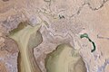
 Lake Eyre during dry season.
 -
 Lake Eyre during rainy season.
 -
 Lake Eyre South.
 -
 Lake Eyre salt crust.


See also
References
- ^ Allen, Robert J.; The Australasian Summer Monsoon, Teleconnections, and Flooding in the Lake Eyre Basin; published 1985 by Royal Geographical Society of Australasia, S.A. Branch; ISBN 0909112096
- ^ "Lake Eyre flooding attracts yachting club interest". ABC News Online. Australian Broadcasting Corporation. 8 March 2007. Retrieved 8 March 2007.
- ^ "IBA: Lake Eyre". Birdata. Birds Australia. Retrieved 26 July 2011.
- ^ Lake Eyre floods again, Australian Geographic, 15 July 2010
- ^ Flooding and storms fill outback lake, ABC News, 9 March 2011
- ^ http://www.lakeeyreyc.com
External links
- NASA Earth Observatory pages on Lake Eyre: [1], [2]
- Lake Eyre Yacht Club website
- Lake Eyre pelican mystery
- Floods of Lake Eyre - Dr Vincent Kotwicki's site
- GSL Aviation - Lake Eyre Scenic Flights