
Tirupattur
Tirupattur
திருப்பத்தூர் Tirupattur | |
|---|---|
Mid Sized town | |
| Nickname: சந்தன நகரம்-Sandana Nagaram-Sandalwood City | |
| Country | |
| State | Tamil Nadu |
| District | Vellore |
| Government | |
| • Chairman | MR.Arasu |
| Elevation | 387 m (1,270 ft) |
| Population (2011) | |
| • Total | 63,798 |
| Languages | |
| • Official | Tamil |
| Time zone | UTC+5:30 (IST) |
| PIN | 635601, 635602 |
| Telephone code | 04179 |
| Vehicle registration | TN-83 |
| Nearest city | Vellore (90 km), Salem (108 km) & Bangalore (130 km) |
| Sex ratio | 993 ♂/♀ |
| Lok Sabha constituency | Thiruvannamalai |
| Vidhan Sabha constituency | Tirupattur |
Tiruppattur is a town located in Vellore District, India, which is one of the oldest towns in Tamil Nadu. It is located approximately 40 km from Krishnagiri, 85 km from Hosur, 85 km from thiruvannamalai and 125 km from Bangalore. The town has mainly small-scale industries and mills. It is an important commercial center from time immemorial (whereas Vaniyambadi and Ambur, which were once smaller towns, have recently flourished). It was a revenue subdivision during British raj and remains so. It has Old Shiva, Vishnu temples and Tanks (Big Tank & Small Tank) built during the Hoysala Dyanasty. It is well connected by road and rail to other important cities of Tamil Nadu such as Thiruvannamalai, Chennai, Salem, Coimbatore and Vellore and to Bangalore in Karnataka. This town is also famous in Islamic religious circles as many great saints "Awliyas" had made it their home town. Some of them are buried at various places in the town, including Hazrath Syed Sha Mohammed alias Syed Khawja Meeran Hussaini Jaffari, Hazrath Syed ShaAmeenuddin Hussaini Chisty ur Kahdri (who is better known as Munshi Hazrath); he was the last among a series of saints who have lived and have been buried at Tirupattur.
The name Tirupattur means a group of ten villages/small towns. There exists a village called Aathiyur (Aathi means Begin) in the southern fringes of the Town and Kodiyur (Kodi means End) in the northern fringes of the town. It is surrounded by several of these villages, making Tirupattur a Taluk. Tirupattur's population and land area are good enough to have political representations in the state legislature of Tamil Nadu (Member of the Legislative Assembly), and part of Thiruvannamalai constituency for the central/federal legislature of India (Member of Parliament as of 2009 elections). Tirupattur Municipality Tirupattur Municipality was constituted as a third grade municipality in the year 1886. As per G.O. No. 194, date: 10.02.1970, classified as Second Grade Municipality. At present from 1.4.1977 onwards as per G.O. No. 654, classified as first grade municipality.
Demographics
In the 2001 Indian census, Tirupathur had a population of 60,803. Males constituted 51% of the population and females 49%. Tirupathur had an average literacy rate of 73%, significantly higher than the national average of 59.5%: male literacy was 79%, and female literacy was 67%. In 2001 in Tirupathur, 11% of the population was under 6 years of age.[1]
In the 2011 census, the city of Tirupathur had a population of 63,798.[2] Males constituted 51% of the population and females 49%. Tirupathur had an average literacy rate of 78%, significantly higher than the national average of 59.5%: male literacy was 80%, and female literacy was 76%. In 2011 in Tirupathur, 11% of the population was under 6 years of age.[citation needed]
Geography
It is known as the "Sandalwood Town" due to the abundant availability of sandalwood trees in the surrounding hills.It is very close to the 4th major hill station of Tamil Nadu, the Yelagiri hills, which is also known as the common man's Ooty.The town is at an average elevation of 388m.
There is another small hill station to the east of Tirupattur (about 6 km), known as (Sowdaykuppam) village.
Location of Tirupattur
The strategic location of this town is such that the town acts as an "urban magnet" to radius of 20 to 25 km all-round. Nearly 200 villages are mainly depending on this town for all their urban needs. The growth is dominated by wholesale agriculture production and Sandalwood. The Urban Municipal town spreads over an extent of 9.26sq.km this is a class-I town in Vellore District is based on population range floating population is increasing day by day.
Infrastructure
The Tirupattur town has 56.059 km length of roads and the municipality is maintaining ‘B’ Grade Bus stand in the heart of the town. There is a century old municipal market having 413 shops which helps in promoting commercial and economic activities of the town.
Climate
This town is known for recording coldest temperature in the Tamil Nadu plains during winter. The seasonal climate conditions are moderate and the weather is uniformly salubrious. The town experiences hot summers and cool winters.
The town gets its majority of rainfall during the south west monsoon period. September and October are the wettest months with around 400mm of rain being received in these two months. The town also experiences fairly frequent thunderstorms in late April and May, which gives necessary relief from the heat, along with the dip in night temperatures. The warmest nights are in May, when the town has an average minimum temperature of 23.4C. The coldest nights are in January, when the average minimum temperatures drop to 16.1C. May is the hottest month with an average maximum of 37.0C.
The highest ever temperature recorded in the town is 46.3C on 7 May 1976. The lowest ever recorded temperature is 10.2C on 15 December 1974. The highest 24 hour precipitation is 167.3mm received on 4 November 1966. The average annual rainfall being received in the town is 982mm. Arun lives in this small village
| Climate data for Tirupattur (1951-2012) | |||||||||||||
|---|---|---|---|---|---|---|---|---|---|---|---|---|---|
| Month | Jan | Feb | Mar | Apr | May | Jun | Jul | Aug | Sep | Oct | Nov | Dec | Year |
| Record high °C (°F) | 35.6 (96.1) |
39.4 (102.9) |
41.2 (106.2) |
45.8 (114.4) |
46.3 (115.3) |
41.8 (107.2) |
39.6 (103.3) |
39.3 (102.7) |
40.0 (104.0) |
37.1 (98.8) |
36.3 (97.3) |
34.3 (93.7) |
46.3 (115.3) |
| Mean daily maximum °C (°F) | 29.6 (85.3) |
32.3 (90.1) |
34.9 (94.8) |
36.3 (97.3) |
37.0 (98.6) |
34.8 (94.6) |
33.2 (91.8) |
33.4 (92.1) |
32.9 (91.2) |
31.5 (88.7) |
29.9 (85.8) |
29.0 (84.2) |
32.9 (91.2) |
| Mean daily minimum °C (°F) | 16.1 (61.0) |
18.3 (64.9) |
20.4 (68.7) |
22.6 (72.7) |
23.4 (74.1) |
23.1 (73.6) |
22.9 (73.2) |
22.9 (73.2) |
22.6 (72.7) |
21.9 (71.4) |
19.8 (67.6) |
17.2 (63.0) |
20.9 (69.7) |
| Record low °C (°F) | 10.3 (50.5) |
10.5 (50.9) |
12.8 (55.0) |
16.6 (61.9) |
18.3 (64.9) |
19.1 (66.4) |
18.4 (65.1) |
17.0 (62.6) |
14.6 (58.3) |
15.5 (59.9) |
12.1 (53.8) |
10.2 (50.4) |
10.2 (50.4) |
| Average precipitation mm (inches) | 1.3 (0.05) |
4.3 (0.17) |
8.3 (0.33) |
22.0 (0.87) |
103.8 (4.09) |
58.5 (2.30) |
124.3 (4.89) |
132.4 (5.21) |
192.5 (7.58) |
190.2 (7.49) |
101.8 (4.01) |
42.1 (1.66) |
981.5 (38.64) |
| Average precipitation days | 0.1 | 0.3 | 0.5 | 1.6 | 5.0 | 3.1 | 5.5 | 5.6 | 7.9 | 8.0 | 4.7 | 1.7 | 44 |
| Source: India Meteorological Department,[3] | |||||||||||||
Nature of Soil The major group of soils that are found in the town are black and red varieties. The red soil constitutes 90 percent while black soil only 10 percent.
Historical Moments
Tirupattur is called as the "Sandal City", Even a rough estimation cannot easily be established on the origin of Tirupattur town, owing to its antiquity.
Through, the inscriptions, so far surveyed by Archeological Survey of India in Tirupattur, it is estimated that this town is more than 1600 years old. During the regimes of various rulers like Cholas, Vijaya Nagara Dynasty, Hoysalas the town had been referred to, by the following names :
Sri Mathava Chaturvedi Mangalam,Veera Narayana Chaturvedi Mangalam, Tiruperur and Brahmapuram (Brahmeeswaram). The present name "Tirupattur" might have got derived from "Tiruperur". Erstwhile "Tiruperur" or "Sri Madhava Chaturvedi Mangalam" was in "Eyyil Nadu", subdivision of "Nigarili Chola Mandalam", division of "Chola Empire".
There existed a fort in the eastern part of the town around 800 years ago. Its entrance might have been near the Kottai Darwaja Sri Veera Anjaneyar Temple, since the word "Kottai" in Tamil means "Fort", and the word "Darwaja" in Hindi/Urdu means "Gate" or "Door". The area is still known as "Kottai"(fort).
The Town was ruled by Cholas, Pallavas, Hoysalas, Vijaya Nagara rulers, Vallala Maharajan, Sambuvarayars, Tipu, Nawabs of Arcot and undoubtedly by the British.
Places to visit
-
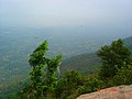
 A view from yelagiri
 -
 Yelagiri hill
 -
 Paragliding in Yelagiri
 -
 A view from yelagiri


- Yelagiri Hills(27 km from Tirupattur)
Yelagiri is a hill-station on the Vaniyambadi-Tirupattur Road, midway between Chennai and Bangalore. Located at an altitude of 1,050 metres (3,500 ft) and spread across 30 km2, the Yelagiri village (also spelt Elagiri at times) is surrounded by orchards, rose-gardens, and green valleys.
- Vainu Bappu Observatory (37 km from Tirupattur - The largest telescope in Asia.)
- Sri vetkaaliamman temple(142 feet height)(13 km)kandhili
- Jalagamparai Falls (14 km from Tirupattur)
Jalagamparai waterfalls is found on the eastern slope of the Yelagiri hills.It is around 14 km from Tirupattur.The best season to visit the falls is from September to February.a small hillside walk to the falls is very pleasant.lord muruga temple in the shape of lingam (lord shiva) near the falls makes a wonderful tourist spot.
- Javadi Hills(35 km from Tiurpattur)
- Bheeman Falls(38 km from Tirupattur)located over jamunamathur hills.
The Javadi Hills are located about 35 km from Tirupattur. The "Sevan Falls" lies near by. In the middle of this hill, lies the Kavalur Observatory, which has several optical and reflective telescopes run and governed by the Indian Institute of Astrophysics.
Temples to visit
There are several temples to be visited in this ancient town,
"Kottai Eeswaran" temple is the largest temple in Tirupattur and it is believed to have an underground passage which connects to the Vellore Fort.It is approximately 1000 years old temple.
- Gajendra Varadharaja perumal Temple,Kamatchiamman/kaliamman Temple,Sri Renuga Parameshwari Temple,Sri SANKARA NILAYAM Temple,Sri Sakthi Saibaba Temple,Dhandapani Temple.,Kumaraswamy Temple,Maya Pillaiyar Temple,Dharwaja Anjaneyar Temple,Nava Shakthi Mariamman Temple Vallalar Nagar Near Asiriyar Nagar,Kannanoor mariyamman temple,Sri Shiva Subramani Swamy Temple Located In Adhiyur Village
Rettai Vinayagar temple, at venugopalswamy kovil street.
Tourist spots in and around Tirupattur
• Yelagiri Hills
- Ezharruvi(seven falls)
• Javadu Hills
- Beeman Water Falls
• Kavalur Observatory • Chandrapuram Caves
- Jalagamparai Water Falls
- Andiappanur Reservoir
HOLY PLACES
Places of worship
Church Mary Help of Christians - Parish, CSI Church, Sacred Heart College Church, kovilur church-pudukottai, Immanuel Church (Immanuel Gospel Mission), Don Bosco School Church. Mosque/ Arabic: Masjid مسجد/ தமிழ்: பள்ளிவாசல் Muslims perform regular & periodic prayers in Masjids Aqsa Masjid/Fort Idga Mosque, Makkah Masjid, Gol Gumbaz Dargah Masjid, Jamiah Masjid, Tawakkal Masjid, Qusray Ilahi (Qazi) Masjid, Qilah Masjid/ Fort Mosque, Poorah Masjid, Bilal Masjid, Madina Masjid, Abu bakker Masjid, Umar Farooque Masjid, Noor Masjid, Ijtimah Masjid, Market Masjid, Nayi Gali Masjid
Map routes
Places adjacent to Tirupattur | |
|---|---|
Roadways
The Tamil Nadu state Bus transport corporation (TNSTC) is providing 85% of transport facilities to this town. Tirupattur is well connected by road and rail to major cities of India. Regarding transportation linkage, the highway (NH 46) from Chennai to Krishnagiri (via) Natrampalli passes through the outskirts of the town. The town is separated by a distance with Chennai (225 km), Bangalore (130 km), Vellore (87 km) and Salem (108 km). Several State Highways connects the town from Dharmapuri (60 km), Krishnagiri (40 km) Vaniyambadi (22 km) and Salem (108 km) section. TNSTC also operates luxury volvo A/C buses (Route no:502B) to Chennai daily. Frequent buses are there to Chennai, Vellore, Salem, Bangalore, Villupuram.
Railways
Tirupattur Railway Station is under the administrative control of the Southern Railways.It is 2 km away from bus stand. Traveling north, Jolarpettai Junction (8 km) is the nearest junction and going south-west, Samalpatti is the next station.Due to proximity to the Jolarpet Railway Junction only few express trains halt here.
The Yelagiri express runs from Tirupattur to Chennai every day.
The Westcoast express (Mangalore-Chennai Central-Manglore) stops at Tiruppattur Railway Station every day. The Other trains that stop at tirupattur station are:
- Yelagiri - Chennai Mail Express - Daily
- Yercaud Express - Daily
- Bangalore-kanyakumari Express -Daily
- Westcoast Express -Daily
- Dhanbad -Allepey Express -Daily
- Erode - jolarpettai Passenger
- Katpadi- Salem Passenger
- Nagercoil -Chennai central Express-only Monday
- Nagercoil-Mumbai CST Express - except Thursday,Saturday, Sunday
- Ernakulam junction-Yeshwantpur Express - only Tuesday
- Ernakulam junction-Bangalore superfast Express - only Monday and Wednesday
- Trivandrum central- Bangalore City junction Express - only on Thursday
- Trivandrum central- Mumbai CST Express - only Saturday
- Coimbatore- Rajkot Express - only Friday
- Trivandrum central- Bangalore City junction Super fast Express - only Sunday
Air
The nearest airports:
Domestic:
- Salem(105 km)
- Vellore Air Strip(85 km)
International:
- Bengaluru (135 km)
- Chennai (225 km)
Hotels
- Vadamalai Bhavan A/C(Veg),Hotel Anbu (Veg),Sri Vadamalai Bhavan (Veg), Ariya Bhavan@Hotel Balamurugan Residency (Veg)Sharma's Bhavan(Veg),Srinivasa Cafe (Veg), Spoonful Restaurant@AGS MALL (Veg), Hotel Sri Aanandha Krishna Vilas (Veg)Lakshmi Cafe (Veg), Hotel Annapoorna (Veg),Sivas Cafe(Veg), Hotel Ranga (Veg), Hotel Sindhu, Hotel Balaji, Raipur Darbar Restaurant(Veg & Non Veg), Shariff Restaurant(Non Veg)Hotel RR (Veg & Non Veg), Hotel Kannan (Veg & Non Veg),
Lodging:
- Hotel Balamurugan Residency, Teachers Colony, Tirupattur,AGS Residency,Jeeva Residency,Sundar Lodge,Sri Padmam Lodge,Thirumalai Lodge,Modern Lodge,Rajeshwari Lodge,Krishna Lodge,Kumaran Lodge,AGR Lodge,Shankar Lodge,Madha Lodge,MRG Lodge,Lakshmi Lodge,Sivaraj Lodge
Schools
Elementary Schools
- Vivekananda Aided Elementary School
- TMS Aided Elementary School
- Government Garden Aided Elementary School
- Our Lady School
Higher Secondary Schools
- DON BOSCO Matriculation Higher Secondary School (SALESIAN Management) http://www.dbtirupattur.org/
- Mary Immaculate Higher Secondary School
- Our Lady's Nursery and Primary School
- Ramakrishna Higher Sccondary School
- Shri Nandanam International Residential School(CBSE)
- Shri Ramesh CBSE international school
- Shri Amrita Higher Secondary School
- Dominic Savio Higher Secondary School
- YMCA Brown Matriculation Higher Secondary School
- C.S.I Girls Matriculation Higher Secondary School
- Ubaibas Girls Higher Secondary School
- Holy Cross Matriculation Higher Secondary School
- TMS Higher Secondary School
- Good Will Matriculation Higher Secondary School
- I.V.N Govt Higher Secondary School
- St. Charles Matriculation Higher Secondary School
- Lions Matriculation Higher Secondary School
- Al Ameen Matriculation Higher Secondary School
- Osmania Higher Secondary School
- Meenakshi Government Girls Higher Secondary School
- Government Boys Higher Secondary School
- Government Garden High School
- RamaKrishna Vidhyalaya Matriculation Higher Secondary School
- Vijayashanthi Vidyalaya Matriculation Higher Secondary School
- Lingannamani Matriculation Higher Secondary School
- Dewan Mohammed Memorial Matriculation Higher Secondary School
- Pudupet Higher Secondary School
Colleges
Arts College
- SACRED HEART College (SALESIAN Management) http://www.shctpt.edu/
- Tirupattur Arts and Science College
- Marappan Lakshmiammal Arts And Science College
- Holy Cross Arts and Science College for Women
- Shree balaji catering college
- Oscar catering and Paramedical College
- Government Thiruvalluvar University college of Arts and Science
- Rex college of catering and paramedical medical science
Engineering
- Sri Nandhanam College of Engineering & Technology
- Sri Nandhanam Martime Academy
- Podhygai College of Engineering & Technology
- Bharathidasan engineering college
Polytechnics
- Pandian Polytechnic College
- Tirupattur Polytechnic College
- Sri Nandhanam Polytechnic College
- Sri pathmam polytechnic tirupattur
Teacher Training Institutes
- Mary Immaculate Teacher Training Institute
- Amritalaya Teacher Training Institute
- Shri Amrita Teacher Training Institute
- Tirupattur Teacher Training Institute
- G.P. Teacher Training Institute
- Sri Padmam Teacher Training Institute
- TES Teacher Training Institute, Jayapuram
- Dr. David Raja Teacher Training Institute, Vengalapuram
B.Ed and M.Ed Colleges
- Amrita College of Education
- Amritalaya College of Education
- Dr. David Raja & Dr. Chandralekha College of Education
- G.P. Secondary Teacher Education Training College
- T.K. Raja College of Education
- Thirumal College of Education
Nursing College
jeya nursing college
This section is empty. You can help by adding to it. (September 2012) |
Non-governmental organizations (NGO's)
- SODEWS (Society For The Development of Economically Weaker Sections)
- Sivalaya Sevai Centre Trust700/4, Kallathur Village, Pudukottai (PO),Tirupattur
- Sri Suyam Seva TrustPost Box No.32, Tirupattur
- Sekinah Gospel TrustKattur Village, Tirupattur
- Muslim Orphanage,Ismailpet, Tirupattur
- Vandhe Mataram Educational Charitable Trust
- Amritalaya Educational Charitable Trust
- Vivekananda Educational Charitable Trust
- TMS Charitable Trust
- Udhaum Ullangal
Banks
- Bank Of India(BOI)- Gandhipet, Vaniyambadi Main Road, Tirupattur
- Canara Bank- Krishnagiri road, Tirupattur
- Catholic Syrian Bank, 1st branch-Sundar lodge building, 2nd branch- SHC Branch, Vaniyambadi Main Road, Tirupattur
- City Union Bank-KAP Thirunadha Nagar, Opp to SHC, Tirupattur
- HDFC Bank-Pudupet Road,Tirupattur
- ICICI Bank-153,Krishnagiri Road, Tirupattur
- Indian Bank(IB)-1st branch -Cutchery street,2nd branch-Gandipet,3rd branchChinnakulam Mariamman Koil Street, Tirupattur
- Indian Overseas Bank, Gandhipet, Vaniyambadi Main Road, Tirupattur
- Karur Vysya Bank (KVB)-Pudupet Road,Tirupattur
- Land Development Bank-Teacher's Colony, Tirupattur
- Pallavan Grama Bank, Krishnagiri Main Road, Tirupattur
- Punjab National Bank (PNB)-Cutchery street,Tirupattur
- State Bank Of India (SBI), Krishnagiri Main Road,Tirupattur
- Syndicate Bank-Chetty Street,Tirupattur
- The Tirupattur Co-operative Bank-Cutchery Street, Tirupattur
- Union Bank Of India (UBI)- 23/24, Chinnakulam Mariyamman kovil Street, Tirupattur
- Vijaya Bank-Asiriyar nagar,Tirupattur
- Federal Bank -RAMAKAPETTAI,TIRUPATTUR
Marriage halls
- AGS Mahal,Shri Vijaya Saravana Mahal,Lalitha Mahal,CKM Kalyana Mandapam,Laila Durairaj Kalyana Mandapam,Rao Mahal,SN Marriage Hall,Thai Sri Naga Thirumana Mandapam,TND Thirumana Mandapam,Arya Vaishya Kalyana Mandapam,NVS Thirumana Mandapam,GB Mahal,AJB Mahal,Kamarajar ,Thirumana Mandapam,Thirupathi Thirumana Mandapam,Varthaga Sangam Thirumana Mandapam.VP Singh Thirumana MandapamAndal Damodharan Kalyaana Mandapam
Theatres
- C.K.C theatre UFO DTS
- New cinema theatre UFO DTS
- Sri Meenakshi Theatre A/C Qube DTS
- Sri Ramajayam Deluxe theatre A/C UFO DTS
- Sri Thirumagal theatre Qube DTS
- Sri Kalaimagal theatre Qube DTS
- Sri Murugan theatre Qube Dolby Digital DTS
- Sri Balamurugan theatre A/C Qube Dolby Digital DTS
Politics & municipal administration
Tirupattur assembly constituency is part of Tiruvannamalai (Lok Sabha constituency).[4]
Municipal Chairman S Arasu M.A,M.Ed
MLA K G Ramesh
MP D Venugopal
VIOLATION OF RULES
Many discrepency involved in this page if this occurs action against particular mail id person will be blocked
References
- ^ Template:GR
- ^ "NPR Report: Tamil Nadu: Vellore: Tirupathur".
- ^ "Climatological Information for Tirupattur,India". India Meteorological Department.
- ^ "List of Parliamentary and Assembly Constituencies" (PDF). Tamil Nadu. Election Commission of India. Retrieved 8 October 2008.