Bloomsbury
| Bloomsbury | |
|---|---|
Location within Greater London | |
| Population | 10,892 (2011 Census. Ward)[1] |
| OS grid reference | TQ305825 |
| London borough | |
| Ceremonial county | Greater London |
| Region | |
| Country | England |
| Sovereign state | United Kingdom |
| Post town | LONDON |
| Postcode district | WC1, NW1 |
| Dialling code | 020 |
| Police | Metropolitan |
| Fire | London |
| Ambulance | London |
| UK Parliament | |
| London Assembly | |
Bloomsbury is a district in the West End of London.[2][3] It is considered a fashionable residential area, and is the location of numerous cultural, intellectual, and educational institutions.[4] It is bounded by Fitzrovia to the west, Covent Garden to the south, St. Pancras to the north, and Clerkenwell to the east.
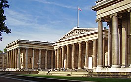
Bloomsbury is home of the British Museum, the largest museum in the United Kingdom, and numerous educational institutions, including the University College London, the University of London, the New College of the Humanities, the University of Law, the Royal Academy of Dramatic Art, and many others. Bloomsbury is an intellectual and literary hub for London, as home of world-known Bloomsbury Publishing, publishers of the Harry Potter series, and namesake of the Bloomsbury Set, a group of British intellectuals which included author Virginia Woolf and economist John Maynard Keynes.
Bloomsbury began to be developed in the 17th century under the Earls of Southampton,[5] but it was primarily in the 19th century, under the Duke of Bedford, which the district was planned and built as an affluent Regency era residential area by famed developer James Burton.[6] The district is known for its numerous garden squares, including Bloomsbury Square, Russell Square, and Tavistock Square, among others.[7]
History
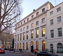
The earliest record of what would become Bloomsbury is in the 1086 Domesday Book, which states that the area had vineyards and "wood for 100 pigs".[5] But it is not until 1201 that the name Bloomsbury is first noted, when William de Blemond, a Norman landowner, acquired the land.[8] The name Bloomsbury is a development from Blemondisberi – the bury, or manor, of Blemond. An 1878 publication, Old and New London: Volume 4, mentions the idea that the area was named after a village called "Lomesbury" which formerly stood where Bloomsbury Square is now,[9] though this etymology is now discredited.
At the end of the 14th century, Edward III acquired Blemond's manor, and passed it on to the Carthusian monks of the London Charterhouse, who kept the area mostly rural.
In the 16th century with the Dissolution of the Monasteries, Henry VIII took the land back into the possession of the Crown and granted it to Thomas Wriothesley, 1st Earl of Southampton.
In the early 1660s, the Earl of Southampton constructed what eventually became Bloomsbury Square. The Yorkshire Grey public house on the corner of Gray's Inn Road and Theobald's Road dates from 1676. The area was laid out mainly in the 18th century, largely by landowners such as Wriothesley Russell, 3rd Duke of Bedford, who built Bloomsbury Market, which opened in 1730. The major development of the squares that we see today started in about 1800 when Francis Russell, 5th Duke of Bedford removed Bedford House and developed the land to the north with Russell Square as its centrepiece.
Culture
Historically, Bloomsbury is associated with the arts, education, and medicine. The area gives its name to the Bloomsbury Group of artists, among whom was Virginia Woolf, who met in private homes in the area in the early 1900s,[10] and to the lesser known Bloomsbury Gang of Whigs formed in 1765 by John Russell, 4th Duke of Bedford. The publisher Faber & Faber used to be located in Queen Square, though at the time T. S. Eliot was editor the offices were in Tavistock Square. The Pre-Raphaelite Brotherhood was founded in John Millais's parents' house on Gower Street in 1848.
The Bloomsbury Festival was launched in 2006 when local resident Roma Backhouse was commissioned to mark the re-opening of the Brunswick Centre, a residential and shopping area. The free festival is a celebration of the local area, partnering with galleries, libraries and museums,[11] and achieved charitable status at the end of 2012. As of 2013, the Duchess of Bedford is a festival patron and Cathy Mager is the Festival Director.[12][13]
Educational institutions
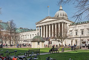
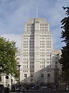
Bloomsbury is home to Senate House and the main library of the University of London, Birkbeck College, Institute of Education, London School of Hygiene and Tropical Medicine, School of Pharmacy, School of Oriental and African Studies, and the Royal Veterinary College and University College London (with the Slade School of Fine Art), a branch of the University of Law, London Contemporary Dance School, the Royal Academy of Dramatic Art, and Goodenough College. Other colleges include the University of London's School of Advanced Study, the Architectural Association School of Architecture in Bedford Square, and the London campuses of several American colleges including Arcadia University, the University of California, University of Delaware, Florida State University, Syracuse University, New York University, and the Hult International Business School.
Also different kinds of tutoring institutions like Bloomsbury International for English Language, Bloomsbury Law Tutors for law education, Skygate Tutors and Topmark Tutors Centre contributing to grow the private tutoring sector in Bloomsbury.
Museums
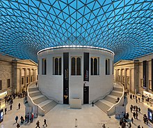
The British Museum, which first opened to the public in 1759 in Montagu House, is at the heart of Bloomsbury. At the centre of the museum the space around the former British Library Reading Room, which was filled with the concrete storage bunkers of the British Library, is today the Queen Elizabeth II Great Court, an indoor square with a glass roof designed by British architect Norman Foster. It houses displays, a cinema, a shop, a cafe and a restaurant. Since 1998, the British Library has been located in a purpose-built building just outside the northern edge of Bloomsbury, in Euston Road.
Also in Bloomsbury is the Foundling Museum, close to Brunswick Square, which tells the story of the Foundling Hospital opened by Thomas Coram for unwanted children in Georgian London. The hospital, now demolished except for the Georgian colonnade, is today a playground and outdoor sports field for children, called Coram's Fields. It is also home to a small number of sheep. The nearby Lamb's Conduit Street is a pleasant thoroughfare with shops, cafes and restaurants.
The Dickens Museum is in Doughty Street. The Petrie Museum and the Grant Museum of Zoology are at University College London in Gower Street.
Churches
Bloomsbury contains several notable churches:
- St George's Church, located on Bloomsbury Way in the south of the area, was built by Nicholas Hawksmoor between 1716 and 1731. It has a deep Roman porch with six huge Corinthian columns, and is notable for its steeple based on the Tomb of Mausolus at Halicarnassus and for the statue of King George I on the top.
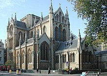
- The Early English Neo-Gothic Church of Christ the King on Gordon Square. It was designed for the Irvingites[14] by Raphael Brandon in 1853. Since 10 June 1954 it has been a Grade I listed building.
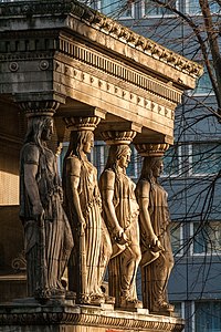
- St Pancras New Church on the northern boundary, near Euston station. This church was completed in 1822, and is notable for the caryatids on north and south which are based on the "porch of the maidens" from the Temple of the Erechtheum.
- The church of St George the Martyr in Queen Square was built 1703–06,[15] and was where Ted Hughes and Sylvia Plath married on Bloomsday in 1956.[16]
- Bloomsbury Central Baptist Church in Shaftesbury Avenue, is the central church of the Baptist denomination. It was opened in 1848, having been built by Sir Samuel Moreton Peto MP, one of the great railway contractors of the age.[17]
Geography
Bloomsbury has no official boundaries, but can be roughly defined as the square of territory bounded by Tottenham Court Road to the west, Euston Road to the north, Gray's Inn Road to the east, and either High Holborn or the thoroughfare formed by New Oxford Street, Bloomsbury Way and Theobalds Road to the south.[5] Bloomsbury merges gradually with Holborn in the south, with St Pancras and King's Cross in the north-east and with Clerkenwell in the south-east.
The area is bisected north to south by the main road Southampton Row/Woburn Place, which has several large tourist hotels and links Tavistock Square and Russell Square – the central points of Bloomsbury. The road runs from Euston and Somers Town in the north to Holborn in the south.
East of Southampton Row/Woburn Place are the Grade II listed Brunswick Centre, a residential and shopping centre,[18] and Coram's Fields children's recreation area. The area to the north of Coram's Fields consists mainly of blocks of flats, built as both private and social housing, which is often considered part of St Pancras[19] or King's Cross[20] rather than north-eastern Bloomsbury. The area to the south is generally less residential, containing several hospitals, including Great Ormond Street, and gradually becomes more commercial in character as it approaches Holborn at Theobald's Road.


The area west of Southampton Row/Woburn Place is notable for its concentration of academic establishments, museums, and formal squares. Here are the British Museum and the central departments and colleges of the University of London, including Birkbeck College, University College London, the School of Oriental and African Studies, and the University of London's School of Advanced Study. The main north-south road in west Bloomsbury is Gower Street which is a one-way street running south from Euston Road towards Shaftesbury Avenue in Covent Garden, becoming Bloomsbury Street when it passes to the west of the British Museum.
For street name etymologies see Street names of Bloomsbury.
Parks and squares
Bloomsbury contains some of London's finest parks and buildings, and is particularly known for its formal squares. These include:
- Russell Square, a large and orderly square; its gardens were originally designed by Humphry Repton. Russell Square Underground station is a short distance away.
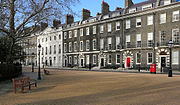
- Bedford Square, built between 1775 and 1783, is still surrounded by Georgian town houses.
- Bloomsbury Square has a small circular garden surrounded by Georgian buildings.
- Queen Square, home to the National Hospital for Neurology and Neurosurgery.
- Gordon Square, surrounded by the history and archaeology departments of University College London, as well as the former home of John Maynard Keynes, the economist. This is where the Bloomsbury Group lived and met.
- Woburn Square and Torrington Square, home to other parts of University College London.
- Tavistock Square, home to the British Medical Association; its eastern edge was the site of one of the 7 July 2005 London bombings.
- Mecklenburgh Square, east of Coram's Fields, one of the few squares which remains locked for the use of local residents.
- Coram's Fields, a large recreational space on the eastern edge of the area, formerly home to the Foundling Hospital. It is only open to children and to adults accompanying children.
- Brunswick Square, now occupied by the School of Pharmacy and the Foundling Museum.
Governance
Bloomsbury is in the parliamentary constituency of Holborn and St Pancras. The western half of the district comprises Bloomsbury ward, which elects three councillors to Camden Borough Council.
The area lay within the parishes of St Giles in the Fields and St George's, Bloomsbury,[21] which were absorbed into the St Giles District as part of the Metropolis Management Act 1855.[22] It is now controlled by the London Borough of Camden.
Economy
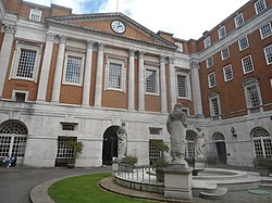
In February 2010, businesses were balloted on an expansion of the InHolborn Business Improvement District (BID) to include the southern part of Bloomsbury. Only businesses with a rateable value in excess of £60,000 could vote as only these would pay the BID levy. This expansion of the BID into Bloomsbury was supported by Camden Council.[23] The proposal was passed and part of Bloomsbury was brought within the InHolborn BID.[24]
Controversy was raised during this BID renewal when InHolborn proposed collecting Bloomsbury, St Giles and Holborn under the name of "Midtown", since it was seen as "too American".[25][26][27] Businesses were informed about the BID proposals, but there was little consultation with residents or voluntary organisations. InHolborn produced a comprehensive business plan aimed at large businesses.[28] Bloomsbury is now part of InMidtown BID with its 2010 to 2015 business plan and a stated aim to make the area "a quality environment In which to work and live, a vibrant area to visit, and a profitable place in which to do business".[29]
Hospitals
Great Ormond Street Hospital for Children and the Royal London Hospital for Integrated Medicine (formerly the Royal London Homoeopathic Hospital) are both located on Great Ormond Street, off Queen Square, which itself is home to the National Hospital for Neurology and Neurosurgery (formerly the National Hospital for Nervous Diseases). Bloomsbury is also the location of University College Hospital, which re-opened in 2005 in new buildings on Euston Road, built under the government's private finance initiative (PFI). The Eastman Dental Hospital is located on Gray's Inn Road close to the Royal National Throat, Nose and Ear Hospital administered by the Royal Free Hampstead NHS Trust.
Transport
Rail
Several London railway stations serve Bloomsbury. There are three London Underground stations in Bloomsbury:
King's Cross St. Pancras station offers step-free access to all lines, whilst Euston Square offers step-free access to the westbound platform. Other stations nearby include: Euston, Warren Street, Goodge Street, Tottenham Court Road, Holborn and Chancery Lane. There is a disused station in Bloomsbury on the Piccadilly line at the British Museum.
There are also three National Rail stations to the north of Bloomsbury:
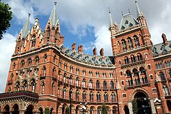
Eurostar services to France, Brussels and the Netherlands begin in London at St Pancras.[30][31]
Buses
Several bus stops can be found in Bloomsbury. All buses passing through Bloomsbury call at bus stops on Russell Square, Gower Street or Tottenham Court Road. Several key London destinations can be reached from Bloomsbury directly, including: Camden Town, Greenwich, Hampstead Heath, Piccadilly Circus, Victoria, and Waterloo. Euston bus station is to the north of Bloomsbury.[32][33]
Road
One of the 13 surviving taxi drivers' shelters in London, where drivers can stop for a meal and a drink, is in Russell Square.[34]
Bloomsbury's road network links the district to several destinations across London. Key routes nearby include:
- the A40 (Bloomsbury Way/High Holborn) - eastbound to Clerkenwell (via A401), Holborn Circus and Bank; westbound to Oxford Circus and Marble Arch
- the A400 (Gower St./Bloomsbury St.) - northbound to Camden Town, Holloway (via A503) and Archway; southbound to Trafalgar Square
- the A4200 (Southampton Row/Woburn Pl.) - northbound to Euston and Camden Town; southbound to Aldwych
- the A501 Inner Ring Road (Euston Rd.) - eastbound towards King's Cross and Angel; westbound to Regent's Park and Marylebone
Air pollution
The London Borough of Camden measures roadside air quality in Bloomsbury. In 2017, average Nitrogen Dioxide (NO2) levels recorded in Bloomsbury significantly exceeded the UK National Objective for cleaner air, set at 40μg/m3 (micrograms per cubic metre).[35]
| Location | NO2 concentration (μg/m3) |
|---|---|
| Euston Road (Automatic) | 83 |
| Euston Road | 92.45 |
| Bloomsbury Street | 80.67 |
Cycling
Several cycle routes cross Bloomsbury, with cycling infrastructure provided and maintained by both the London Borough of Camden and Transport for London (TfL). Many routes across Bloomsbury feature segregated cycle tracks or bus lanes for use by cyclists. Additionally, Bloomsbury is connected to the wider London cycle network via several routes, including:
- Quietway 1 (Q1) - Running on segregated cycle track or residential streets, Q1 carries cyclists on an unbroken, signposted cycle route from Covent Garden, via Bloomsbury, to King's Cross and Kentish Town. The route is carried south-north through Bloomsbury on Bury Place, Montague Street, Montague Place, Malet Street, Tavistock Place, and Judd Street.[36]
- Quietway 2 (Q2) - Running on segregated cycle track or residential streets, Q2 carries cyclists on an unbroken, signposted cycle route from Bloomsbury to Walthamstow. In Bloomsbury, the route begins to the east of Russell Square, leaving the area eastbound on Guildford Street. En route to Walthamstow, Q2 passes through Angel, Islington, London Fields and Hackney Central. TfL proposes that Q2 will head west from Bloomsbury in the future, towards East Acton.[37]
- Cycle Superhighway 6 (CS6) - CS6 passes to the east of Bloomsbury, via Judd Street, Tavistock Place and Regent's Square. To the north, CS6 terminates at King's Cross. To the south, CS6 passes through Farringdon, Ludgate Circus and Blackfriars en route to Elephant and Castle.[38]
Notable residents


- Ada Ballin (1863–1906), magazine editor and writer on fashion[39]
- J. M. Barrie (1860–1937), playwright and novelist, lived in Guilford Street and 8 Grenville Street when he first moved to London;[40] this is where Barrie situated the Darlings' house in Peter Pan.[41]
- Vanessa Bell (1879–1961), painter, sister of Virginia Woolf, lived at 46 Gordon Square.
- William Copeland Borlase M.P. (1848–1899), died bankrupt and disowned by his family at 34 Bedford Court Mansions.
- Vera Brittain (1893–1970) and Winifred Holtby (1898–1935) lived at 58 Doughty Street.
- Randolph Caldecott (1846–1886), illustrator, lived at 46 Great Russell Street.
- William Cavendish, 3rd Duke of Devonshire (1698–1755), sold the Old Devonshire House at 48 Boswell Street.
- Charles Darwin (1809–1882), lived at 12 Upper Gower Street in 1839.[42]
- George Dance (1741–1825), architect, lived at 91 Gower Street.
- Charles Dickens (1812–1870), novelist, lived at 14 Great Russell Street, Tavistock Square and 48 Doughty Street.
- George du Maurier (1834–1896), artist and writer, lived at 91 (formerly 46) Great Russell Street.
- Benton Fletcher (1866–1944), housed his keyboard collection at the Old Devonshire House, 48 Boswell Street, in the 1930s and 40s.
- E. M. Forster (1879-1970), novelist, essayist, and broadcaster, resided in Brunswick Square
- Ricky Gervais (born 1961), comedian, lived until recently in Southampton Row, Store Street and owned one of the penthouses in Bloomsbury Mansions in Russell Square, WC1.
- Mary Anne Everett Green (1818–1895), Calenderer of State Papers, author of Lives of the Princesses of England, mother of Evelyn Everett-Green, a prolific 19th-century novelist.
- Philip Hardwick (1792–1870) and Philip Charles Hardwick (1822–1892), father and son, architects, lived at 60 Russell Square for over ten years.
- Travers Humphreys (1867–1956), barrister and judge, was born in Doughty Street.
- John Maynard Keynes, (1883–1946), economist, lived for 30 years in Gordon Square.
- Vladimir Lenin, 1870–1924, founder of the USSR, lived here in 1908.[43]
- Emanuel Litvinoff (1915–2011), author, poet, playwright and human rights campaigner, lived for 46 years in Mecklenburgh Square.
- Edmund Lodge (1756–1839), officer of arms and writer on heraldry, died at his Bloomsbury Square house on 16 January 1839.[44]
- Bob Marley (1945–1981), musician, lived in 34 Ridgmount Gardens for six months in 1972.
- Charlotte Mew (1869–1928), poet, was born at 30 Doughty Street and lived there until the family moved nearby to 9 Gordon Street, in 1890.[45][46]
- Jacquie O'Sullivan (born 1960), musician and former member of Bananarama.
- Dorothy Richardson (1873–1957), novelist, lived at 7 Endesleigh Street and 1905–6 Woburn Walk. Her experiences are recorded in her autobiographical novel, in thirteen volumes, Pilgrimage.[47]
- Sir Francis Ronalds (1788–1873), inventor of the electric telegraph, lived at 40 Queen Square in 1820–1822.[48]
- Dorothy L. Sayers (1893–1957), novelist lived at 24 Great James Street from 1921–1929. Her main female character Harriet Vane also lived in Bloomsbury.
- Alexei Sayle (born 1952), English stand-up comedian, actor and author.[49]
- John Shaw Senior (1776–1832) and John Shaw Junior (1803–1870), father and son, architects, lived in Gower Street.
- Catherine Tate (born 1968), actress and comedian, was brought up in the Brunswick Centre, close to Russell Square.
- Wee Georgie Wood (1895–1979), actor and comedian, lived and died at Gordon Mansions on Torrington Place.[50]
- Virginia Woolf (1882–1941), author, essayist, and diarist, resided at 46 Gordon Square (1904-7) and 52 Tavistock Square (1924-39).
- Thomas Henry Wyatt (1807–1880), architect, lived at 77 Great Russell Street.
- John Wyndham (1903–1969), lived at the Penn Club in Tavistock Square (1924–38) and then (except for 1943–46 army service) at the Club's present address, 21–22 Bedford Place, off Russell Square, until his marriage in 1963 to Grace Isabel Wilson, who had lived in the next room at the Club.
- William Butler Yeats (1865–1939), poet, dramatist and prose writer, lived at Woburn Walk.
References
- ^ "Camden Ward population 2011". Neighbourhood Statistics. Office for National Statistics. Retrieved 20 October 2016.
- ^ Atkins, Peter J. "How the West End was won: the struggle to remove street barriers in Victorian London." Journal of Historical Geography 19.3 (1993): 265.
- ^ How the West End was won: the struggle to remove street barriers in Victorian London. Atkins, P J. Journal of Historical Geography; London Vol. 19, Iss. 3, (Jul 1, 1993): 265.
- ^ Senate House - 10 Reasons Why Bloomsbury is the Coolest Place
- ^ a b c The London Encyclopaedia, Edited by Ben Weinreb and Christopher Hibbert. Macmillan London Ltd 1983
- ^ Burton's St. Leonards, J. Manwaring Baines F.S.A., Hastings Museum , 1956.
- ^ Guide to London Squares Archived 12 October 2007 at the Wayback Machine. Retrieved 8 March 2007.
- ^ Camden Council Local History Archived 27 September 2007 at the Wayback Machine. Retrieved 8 March 2007.
- ^ 'Bloomsbury', Old and New London: Volume 4 (1878), pp. 480–89 Date accessed: 8 March 2007
- ^ Fargis, Paul (1998). The New York Public Library Desk Reference – 3rd Edition. Macmillan General Reference. p. 262. ISBN 0-02-862169-7.
- ^ "Preview: The Bloomsbury Festival". Londonist. Londonist. 16 October 2012. Retrieved 8 October 2013.
- ^ "History". Bloomsbury Festival. Bloomsbury Festival. October 2013. Archived from the original on 24 October 2013. Retrieved 8 October 2013.
- ^ "The Team". Bloomsbury Festival. Bloomsbury Festival. October 2013. Retrieved 8 October 2013.
- ^ Church of Christ the King Archived 6 November 2007 at the Wayback Machine. Retrieved 8 March 2007.
- ^ St George's Bloomsbury Archived 23 November 2007 at the Wayback Machine. Retrieved 8 March 2007.
- ^ Walking Literary London, Roger Tagholm, New Holland Publishers, 2001.
- ^ Bloomsbury Central Baptist Church History Page. Retrieved 27 May 2014.
- ^ Brunswick Centre – Restoration Archived 8 October 2007 at the Wayback Machine. Retrieved 8 March 2007.
- ^ View London. Retrieved 8 March 2007.
- ^ Corams Fields Archived 20 November 2008 at the Wayback Machine. Retrieved 8 March 2007.
- ^ Sir Walter Besant and Geraldine Edith Mitton, "Holborn and Bloomsbury: The Fascination of London". Adam & Charles Black, London, 1903. Retrieved 26 July 2010.
- ^ "London History - London, 1800-1913 - Central Criminal Court". www.oldbaileyonline.org. Retrieved 26 July 2010.
- ^ "Council supports proposed expansion of Business Improvement District inholborn accessed 13 March 2010". Camden.gov.uk. 9 November 2009. Archived from the original on 11 June 2011. Retrieved 6 July 2010.
- ^ Bloomsbury, Holborn and St Giles business improvement district renewal ballot – announcement of result accessed 13 March 2010 Archived 6 March 2010 at the Wayback Machine
- ^ "Bloomsbury regroups for a bright new future accessed 13 March 2010". Thisislondon.co.uk. Archived from the original on 25 January 2010. Retrieved 6 July 2010.
- ^ "Holborn Midtown accessed 13 March 2010". Janeslondon.com. 22 January 2010. Retrieved 6 July 2010.
- ^ Hill, Dave (25 January 2010). "Bid to re-brand Holborn, Bloomsbury and St Giles accessed 113 March 2010". Guardian. Retrieved 6 July 2010.
- ^ "IH_BID2010_document_061109:IH_BID2010_document" (PDF). Retrieved 6 July 2010. [dead link]
- ^ "Our Purpose". Midtown BID. Archived from the original on 13 January 2013. Retrieved 20 December 2012.
- ^ "London St Pancras International". Eurostar.
{{cite web}}: Check|archive-url=value (help) - ^ "London's Tube and Rail Services Map" (PDF). Transport for London. Archived from the original (PDF) on 10 April 2019.
- ^ "Buses from Russell Square" (PDF). Transport for London. 24 November 2018. Archived from the original (PDF) on 23 April 2019.
- ^ "Buses from Goodge Street" (PDF). Transport for London. 17 June 2017. Archived from the original (PDF) on 23 April 2019.
- ^ Cabmen's Shelters. Retrieved 24 August 2010.
- ^ a b "Air Quality Annual Status 2017". London Borough of Camden. 31 May 2018. Archived from the original on 23 April 2019.
- ^ "Quietway 1 (North): Covent Garden to Kentish Town" (PDF). Transport for London. Archived from the original (PDF) on 6 April 2019.
- ^ "Quietway 2 (East): Bloomsbury to Walthamstow" (PDF). Transport for London. Archived from the original (PDF) on 7 April 2019.
- ^ "Cycle Superhighway 6: King's Cross to Elephant & Castle" (PDF). Transport for London. Archived from the original (PDF) on 10 April 2019.
- ^ Ada Ballin[permanent dead link], ODNB, Retrieved 6 October 2016
- ^ Mackail, Denis: The Story of J.M.B. Peter Davies, 1941
- ^ J.M. Barrie: Peter Pan, or the Boy Who Wouldn't Grow Up. Act I. Hodder & Stoughton, 1928
- ^ Charles Darwin. Retrieved 8 March 2007.
- ^ London Remembers - Vladimir Ilyich Lenin
- ^ ODNB: Lucy Peltz, "Lodge, Edmund (1756–1839)" Retrieved 11 March 2014
- ^ "Charlotte Mew". Poetry Foundation. 1 April 2017. Retrieved 2 April 2017.
- ^ "In-Conference: Diana Collecott -- HOW2". www.asu.edu. Retrieved 2 April 2017.
- ^ Windows on Modernism: Selected Letters of Dorothy Richardson, ed Gloria G, Fromm. Athens, Georgia: University of Georgia Press 1995, p. xxx; The Dorothy Richardson Society web site [1].
- ^ Ronalds, B.F. (2016). Sir Francis Ronalds: Father of the Electric Telegraph. London: Imperial College Press. ISBN 978-1-78326-917-4.
- ^ Alexei Sayle (8 October 2013). "Alexei Sayle: Bloomsbury by bike - video" (Video upload). The Guardian. Retrieved 8 October 2013.
- ^ Bushell, Peter (1983). London's Secret History. Constable. p. 179.
External links
 London/Bloomsbury travel guide from Wikivoyage
- Bloomsbury area guide
- "UCL Bloomsbury Project". University College London.

