National Highway 40 (India) (old numbering)
Appearance
| National Highway 40 | ||||
|---|---|---|---|---|
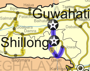
 Road map of India with National Highway 40 highlighted in blue | ||||
| Route information | ||||
| Part of | ||||
| Length | 216 km (134 mi) | |||
| Major junctions | ||||
| From | Jorabat, Meghalaya | |||
| To | Jowai, Meghalaya | |||
| Location | ||||
| Country | India | |||
| States | Meghalaya | |||
| Primary destinations | Umling - Shillong | |||
| Highway system | ||||
| ||||
National Highway 40 (NH 40) is a National Highway of India entirely within the state of Meghalaya that connects Jorabat and Jowai in Meghalaya, India. It covers a distance of 216 km (134 mi).[1]
Route
See also
- List of National Highways in India (by Highway Number)
- List of National Highways in India
- National Highways Development Project
References
- ^ "National Highways and their lengths". National Highways Authority of India. Retrieved 2009-02-12.


