
Ranchi: Difference between revisions
ClueBot NG (talk | contribs) m Reverting possible vandalism by 59.161.191.41 to version by Resolute. False positive? Report it. Thanks, ClueBot NG. (447099) (Bot) |
No edit summary |
||
| Line 24: | Line 24: | ||
|footnotes = |
|footnotes = |
||
}} |
}} |
||
''' |
'''QUISER AMAN IS A RENOUNED PERSONALITY OF RANCHI''' {{audio|Ranchi.ogg|pronunciation}} ({{Lang-hi|राँची}}, {{lang-ur|{{Nastaliq|رانچی}}}}, {{Lang-bn|রাঁচি}}) is the [[List of state and union territory capitals in India|capital]] of the Indian state of [[Jharkhand]]. Jharkhand accounts for 40% of the mineral resources of India{{Citation needed|date=November 2010}}. Ranchi accounts for 50% mineral production of the state{{Citation needed|date=November 2010}}, nearing about 18% of nation's mineral production{{Citation needed|date=November 2010}}. For this reason Ranchi is also called the Manchester of the East{{Citation needed|date=November 2010}}. Ranchi was the centre of the Jharkhand movement<ref>{{cite web | url=http://country-studies.com/india/jharkhand-movement.htmll | title=Jharkhand Movement | publisher= Country Studies | accessdate=2009-05-07}} {{Dead link|date=September 2010|bot=H3llBot}}</ref> for a separate state for the tribal regions of South Bihar, northern Orissa, Western West Bengal and the present eastern Chhattisgarh. Jharkhand State was formed on 15 November 2000 by carving the Bihar divisions of [[Chota Nagpur Division|Chota Nagpur]] and [[Santhal Parganas]].{{Citation needed|date=November 2010}} |
||
The name Ranchi comes from the original [[Oraon]] village Archi at the site.<ref>Cultural Configuration of Ranchi, Lalita Prasad Vidyarthi, Rajendra Behari Lal, India. Planning Commission. Research Programmes Committee, 1969, pg 306.</ref> Archi derives from the Oraon word for bamboo grove or stave. According to legend, after an altercation with a spirit, a farmer beat the spirit with his bamboo stave or ''archi''. The spirit shouted ''archi, archi, archi'' and vanished; Archi became Rachi, and Rachi became Ranchi.<ref>Journal and Proceedings of the Asiatic Society Of Bengal, Volume 4, No. 11, 1927, "The Etymology of Ranchi, pg 601.</ref> Up to 1927, the place was known as Rachi{{Citation needed|date=November 2010}}. One historically significant neighborhood is Doranda ('duran' 'दुरङ' means song and 'daah' 'दअः' means water in the [[Mundari language]]), between the Hinoo (Bhusur) & Harmoo Rivers, where the civil station, treasury and church established by the [[British Raj]] were destroyed by rebel forces during the [[Sepoy Mutiny]].<ref>Kaye's and Malleson's history of the Indian mutiny of 1857-8, Volume 4, By Sir John William Kaye, George Bruce Malleson, W.H. Allen, 1889, pg 95.</ref> The present Purani (old) Ranchi marks the site of the old village of Archi. |
The name Ranchi comes from the original [[Oraon]] village Archi at the site.<ref>Cultural Configuration of Ranchi, Lalita Prasad Vidyarthi, Rajendra Behari Lal, India. Planning Commission. Research Programmes Committee, 1969, pg 306.</ref> Archi derives from the Oraon word for bamboo grove or stave. According to legend, after an altercation with a spirit, a farmer beat the spirit with his bamboo stave or ''archi''. The spirit shouted ''archi, archi, archi'' and vanished; Archi became Rachi, and Rachi became Ranchi.<ref>Journal and Proceedings of the Asiatic Society Of Bengal, Volume 4, No. 11, 1927, "The Etymology of Ranchi, pg 601.</ref> Up to 1927, the place was known as Rachi{{Citation needed|date=November 2010}}. One historically significant neighborhood is Doranda ('duran' 'दुरङ' means song and 'daah' 'दअः' means water in the [[Mundari language]]), between the Hinoo (Bhusur) & Harmoo Rivers, where the civil station, treasury and church established by the [[British Raj]] were destroyed by rebel forces during the [[Sepoy Mutiny]].<ref>Kaye's and Malleson's history of the Indian mutiny of 1857-8, Volume 4, By Sir John William Kaye, George Bruce Malleson, W.H. Allen, 1889, pg 95.</ref> The present Purani (old) Ranchi marks the site of the old village of Archi. |
||
Revision as of 03:56, 5 June 2011
This article has an unclear citation style. (December 2010) |
Template:Infobox Indian jurisdiction QUISER AMAN IS A RENOUNED PERSONALITY OF RANCHI (Hindi: राँची, Urdu: رانچی, Bengali: রাঁচি) is the capital of the Indian state of Jharkhand. Jharkhand accounts for 40% of the mineral resources of India[citation needed]. Ranchi accounts for 50% mineral production of the state[citation needed], nearing about 18% of nation's mineral production[citation needed]. For this reason Ranchi is also called the Manchester of the East[citation needed]. Ranchi was the centre of the Jharkhand movement[1] for a separate state for the tribal regions of South Bihar, northern Orissa, Western West Bengal and the present eastern Chhattisgarh. Jharkhand State was formed on 15 November 2000 by carving the Bihar divisions of Chota Nagpur and Santhal Parganas.[citation needed]
The name Ranchi comes from the original Oraon village Archi at the site.[2] Archi derives from the Oraon word for bamboo grove or stave. According to legend, after an altercation with a spirit, a farmer beat the spirit with his bamboo stave or archi. The spirit shouted archi, archi, archi and vanished; Archi became Rachi, and Rachi became Ranchi.[3] Up to 1927, the place was known as Rachi[citation needed]. One historically significant neighborhood is Doranda ('duran' 'दुरङ' means song and 'daah' 'दअः' means water in the Mundari language), between the Hinoo (Bhusur) & Harmoo Rivers, where the civil station, treasury and church established by the British Raj were destroyed by rebel forces during the Sepoy Mutiny.[4] The present Purani (old) Ranchi marks the site of the old village of Archi.

History
Ranchi is the headquarters of Ranchi district. Earlier the name of the district was Lohardaga. The old district had come into existence after the creation of the non-regulation South – West frontier as a result of the Kol uprising in 1831-32. The name of the district was changed in 1899 from Lohardaga to Ranchi after the name of a small village now comprised within the headquarters station.
Geography
Ranchi is located at 23°21′N 85°20′E / 23.35°N 85.33°E.[5] The total area covered by the Ranchi municipal area is 175.12 square kilometres and the average elevation of the city is 629 m above sea level.
Ranchi is located on the southern part of the Chota Nagpur plateau which forms the eastern edge of the Deccan plateau. Ranchi is referred to as the "City of Waterfalls", due to the presence of numerous large and small falls of around the close vicinity of the city. The most popular ones are Dasham, Hundru, Jonha Falls, Hirni and Panchghat.
The Subarnarekha river and its tributaries constitute the local river system. Dams in Kanke, Rukka and Hatia have been built over these channels to cater to the water requirements of majority the population.
Ranchi has a hilly topography and its combination with dense tropical forests ensures that it enjoys a comparatively moderate climate compared to the rest of the state. Previously, it was accorded a 'hill station' status during the British rule. Rapid population growth and industrialization have caused considerable change in the weather pattern and rise in average temperatures. This has resulted in gradual loss of this "Hill Station" like status.
Places adjacent to Ranchi | |
|---|---|
Climate
| Ranchi | ||||||||||||||||||||||||||||||||||||||||||||||||||||||||||||
|---|---|---|---|---|---|---|---|---|---|---|---|---|---|---|---|---|---|---|---|---|---|---|---|---|---|---|---|---|---|---|---|---|---|---|---|---|---|---|---|---|---|---|---|---|---|---|---|---|---|---|---|---|---|---|---|---|---|---|---|---|
| Climate chart (explanation) | ||||||||||||||||||||||||||||||||||||||||||||||||||||||||||||
| ||||||||||||||||||||||||||||||||||||||||||||||||||||||||||||
| ||||||||||||||||||||||||||||||||||||||||||||||||||||||||||||
Ranchi has a humid subtropical climate. However, due to its position and the forests around the city, it is known for its pleasant climate. Its climate is the primary reason why Ranchi was once the summer capital of the undivided State of Bihar. Temperature ranges from maximum 42 to 20°C during summer, and from 25 to 0°C during winter. The annual rainfall is about 1430 mm (56.34 inches). From June to September the rainfall is about 1,100 mm.
Demographics
In the 2001 India census,[6] Ranchi had a population of 846,454. As per the Ranchi Municipal Corporation the current population figure stands approximately at 12.5 Lakhs (1.25 Million). Males constitute 53% of the population and females 47%. Ranchi has an average literacy rate of 74%, higher than the national average of 59.5%: male literacy is 80%, and female literacy is 68%. In Ranchi, 13% of the population is under 6 years of age. Interestingly, as per the last Census it was found that the cases of Divorce in this State has increased manyfold. The city witnessed a sudden surge in population after the declaration of the new state of Jharkhand in 2000. Owing to the rising employment opportunities and opening of numerous regional and state level offices, banks, and FMCG companies, the city witnessed a rapid influx of employment seeking migrants. As per a study done by ASSOCHAM in late 2010, Ranchi was the highest employment generating Tier-III city in India with a share of 16.8%, followed by Managlore and Mysore.
Education
Primary and Secondary Schools Ranchi is a regional hub for leading Pre-schools, Primary and Secondary schools. Major schools include:
- St.Francis School, Harmu
- Surendranath Centenary School
- St. Anthony's School, Doranda
- St. Thomas School, Dhurwa
- Taurian World School
- Sapphire International School
- Sarala Birla Public School
- St. Johns High School
- St. Aloysius High School
- Bishop Westcott Girls' School
- Bishop Westcott Boys' School
- Jawahar Vidya Mandir, Shyamali
- Delhi Public School
- Sacred Heart Convent
- Loreto Convent Doranda
- Guru Nanak Higher Sec School,Ranchi
- LEBB High School
- SS Doranda Girls' High School
- Chotanagpur Girls' School
- Balika Siksha Bhawan
- St. Xavier's School, Ranchi
- 4 Kendriya Vidyalayas
- Zila School
- St Paul's School
- Yogoda Satsanga Vidyalaya
- DAV Public School, Gandhinagar
- DAV Hehal, Itki Road Ranchi
- DAV Kapildev Public School, Kadru
- Gauri Dutt Mandeliya High School, Ratu Road
- DAV Public School, Bariatu
- Kairali School, HEC
- Saraswati Shishu Vidya Mandir,Dhurwa
Other important educational organisations are:
- NIFFT National Institute of Foundry and Forge Technology.
- IIM Ranchi Indian Institute of Management
- CIP (Central Institute of Psychiatry),Kanke
- BIT Birla Institute of Technology,Mesra
- Xavier Institute of Social Services(XISS)[1],
- RIMS Rajendra Institute of Medical Sciences,
- St. Xavier's College
Most of the government-run schools in Ranchi are affiliated to Jharkhand Academic Council, while most of the private schools are affiliated to ICSE or CBSE boards.
Most of the colleges and institutions of higher education are under the jurisdiction of Ranchi University. There are also agicultural and veterinary colleges, which are part of the Birsa Agricultural University located at Kanke and ICFAI University. XISS, Ranchi is one of the oldest B schools [2]. Other institutions are: Ranchi College,[3], Women's College,[4], St. Xavier's College, Yogoda Satsang College, Nirmala College,[5], Marwari Boys' College, Gossner College and Doranda College.In 2009 the Central University of Jharkhand was established by the government of India. Ranchi is also marking its presence felt globally by inception of country's famous and trustworthy management brand IIM.
Transport
Road
The State Bus Terminus is located near the Ranchi Railway station. Khad Garaha and Ratu Road are private bus stations.
A ring road around the city is under construction; it covers almost one quarter of the complete ring (23 km). It would help reduce the pressure of heavy vehicles on the streets of the state capital A new city bus service has been launched under JNUURM to connect various parts of the city for the benefit of commuters, and has been very popular with everyone. [[File:Example.jpg]
Rail
Ranchi has frequent connections with cities like New Delhi, Mumbai, Kolkata, Jabalpur, Patna, Bhubaneshwar, Bangalore, Allepey, Jammu Tavi, Guwahati, Gorakhpur etc. The city lacks direct connectivity with Bhopal, Indore, Jaipur, Ahmedabad, Hyderabad, Goa, Lucknow, Pune and other prominent state capitals.
The railway stations in the city are: Tatisilwai, Namkum, Ranchi Junction, Argora and Hatia.
Airport
Ranchi Airport - Officially known as The Birsa Munda Airport, approximately 7 km south of the city center. The airport has a single runway 13/31 of dimension 8,900 ft (2,700 m) x 150 ft (46 m) in length x width and supports navigation/traffic control systems such as HIRL and PAPI, ASPL and Apron Flood Lights. It is served by most major national carriers such as Indian Airlines/Air India, JetLite,and Kingfisher Red providing point-to-point connections to New Delhi, Kolkata, Mumbai and Patna by daily flights in multiple schedules.
A new Integrated Terminal (International/Domestic) is under construction at the North-Eastern end of the old terminal and will be commissioned by the end of year 2012. The new terminal will boast of several modern facilities like Inline Baggage Screening, Custom Clearance, Rapid Baggage Handling, Retail Area, 2 Contact Stands/ Jet Bridge and a large parking apron with a capacity of holding 6 narrow-body jets. A new taxiway to this apron area has already been commissioned. It is expected that after the commissioning of this new integrated terminal, Ranchi might get a few international connections as well (probably a budget carrier from the Gulf or South Asia).
Trade, commerce, and industry
As an important administrative and military base of the eastern India during the British Era, Ranchi developed as an important centre of trade and commerce, including a traditional base for sericulture and manufacture of shellac. Villages around Ranchi have been described as the 'vegetable bowl' of Jharkhand and truckloads of green vegetables are transported from the city to different parts of Jharkhand, Bihar, and to Kolkata.
After India gained independence, Ranchi continued to grow, and a number of industrial facilities were located in and around the city. Along with other two industrial townships of Jamshedpur and Bokaro, it completes the industrial structure of Jharkhand. Industrial facilities of Ranchi include the Heavy Engineering Corporation (now associated with ISRO also), MECON which is associated with expansion and modernisation of most of the steel plants, CCL, CMPDI and Shipping Corporation of India, Garden Reach Shipbuilders & Engineers Ltd, (Marine Diesel Engine Plant)[6] for overhauling & manufacturing of mtu 183, 396 & 4000 series Marine Diesel engine in collaboration with Motoren-und Turbinen Union (MTU) Ludwigsfelde GMBH of Deutscheland (Germany).
The Steel Authority of India Limited (SAIL) founded its research and development center in Ranchi in 1974, and today it is the largest steel research centre of the country, employing over 350 scientists and addressing the R&D needs of SAIL while also providing scientific services to other organizations.
Ranchi also houses Usha Martin Limited, a pioneer in the manufacturing of steel wires and wire ropes, located in Tatisilwai, approx 15 km from the main city.
Health care facilities and hospitals
The city is the medical centre for the region of about 400 km in radius. Many hospitals, both private and public, dot the city.
- The Rajendra Medical College now known as Rajendra Institute of Medical Sciences, RIMS is the largest of three medical colleges in the state. Neurodiagnostic facilities exist in the Advanced Diagnostic Centre. The Indian corporate hospital chain (Apollo Hospitals Group) runs a private hospital named Abdur Razzaque Ansari Memorial Hospital (ARAM) which is the only super speciality hospital in this area of the country. It was founded in 1996 by the Chotanagpur Regional handloom weavers Co-operative Union Ltd and the members of the family of the late Abdur Razzaque Ansari which is on the outskirts of the city. Other private run hospitals include Seva Sadan, Raj Hospital, Guru Nanak Hospital and Seventh Day Adventist Hospital.
- In addition, Ranchi has secondary care hospitals belonging to central government undertakings such as MECON Ispat Hospital, Gandhinagar CCL Hospital, HEC Plant Hospital.
- Ranchi is famous across India for its psychiatric care centers. Ranchi has some of the largest facilities for mentally-challenged patients at Kanke. There are three major hospitals taking care of patients with psychiatric illnesses.
- Central Institute of Psychiatry
- RINPAS, Kanke[clarification needed]
Tourist attractions
Temples


- Rajrappa Mandir About 65 km from Ranchi for the worship of Goddess Kali, known as Chhinnamastika. Also a tourist place; has good picnic spots.
- Pahari Temple - heart of the city
- Durga Badi - near Firayalal Chowk at the heart of the city.
- Kali Bari - Church Road.
- Jagannathpur Temple - built in the architectural style of Puri temples about 300 years old, known for the Chariot Festival ( Rath Yatra) attended by a large number of devotees every year
- Surya Temple - 38 km from Ranchi on Ranchi-Tata NH Road
- Parasnath or Shikharjee - a major pilgrimage of the Jain's about 200 km from Ranchi in Girdih District.
- Ramakrishna Mission and Ashram, Morabadi
- Dewri Temple - 58 km from Ranchi on Ranchi-Tata NH 33 road.
- Doranda Jain Mandir - 4 km from Ranchi
- Headquarters of Yogoda Satsanga Society of India, founded by Paramahansa Yogananda, situated about 200 metres from Ranchi railway station.
- Buddha Vihar, Chhotanagpur Buddha Society, Nepal House, Doranda Ranchi.
Hirini Falls are one Of the famous falls of Ranchi (Jharkhand)
- Tapoban Mandir - About 1 km from Ranchi Jn near Over Bridge at Nibaranpur, Ranchi.
- Swarnarekha - About 15 km from Ranchi in Piska Nagri.
There are also falls like Hundru, Hirni, Dasam, Panchghagh, Jonha.
Festivals
Ranchi is home to people of many castes, creeds and sects. All festivals are celebrated with pomp, glory and in harmony.
Parks and resorts

- Nakshatra Van - near Raj Bhawan (Governor's House)
- Aqua World (Machhli Ghar)- just beside Nakshtra Van, near Raj Bhawan.
- Birsa Zoological Park - 14 km from Ranchi
- Night Safari - 14 km from Ranchi
- Deer Park - 16 km from Ranchi on Ranchi-Khunti Road
- Sidhu Kaanhu Park
- Dr. Zakhir Hussain Park
- Ranchi Hill / Rici Buru - Pahari Baba Temple
- Tagore hill - Morabadi, 5 km from the center of the city
- Rock Garden - Kanke Road, 4 km from the center of the city
- Fun Castle - Ratu, 7 km from Ranchi
- Crocodile Farm - Ormanjhi, 19 km from Ranchi
- Ranchi Lake - Man made lake digged by the British in the heart of the city
- Dhurwa Dam
Falls

- Hundru Falls - One of the Highest waterfalls of Eastern India.
- Dasham Falls
- Jonha Falls - About 35 km from Ranchi
- Hirni and Panchghagh Falls about 40–45 km away from the city, very popular with picnickers
Science Centre
Media
The city has several newspapers, the oldest one is Ranchi Express and the most circulated (?) being Hindustan, Dainik Jagran, Prabhat Khabar, Aaj Daily, Ranchi Express and the latest addition is the Dainik Bhaskar. Amongst English dailies The Times of India, Hindustan Times, The Hindu and The Pioneer, The Daily Telegraph are widely circulated in the city, and Bengali Dailies like Anandabazar Patrika and Bartaman.
There are also some local TV news channels delivered through the cable TV network, Jharkhand News 24, PBL Nazar and Jharkhand TV. Besides these, ETV Bihar/Jharkhand and Sahara Samay Bihar/Jharkhand are two other TV Channels that run deciated programming for the region and have pan-India presence.
Besides the AIR (All India Radio) run Vividh Bharti 103.3 FM radio station, there are private FM Channels as well. Radiomantra 91.9 FM(life ka mantra) is owned by the Dainik Jagran Media house. Big 92.7 FM which a joint venture by Anil Dhirubhai Ambani and Adlabs, 104.8 Radio Dhoom owned by Prabhat Khabar has recently been launched and the B.A.G group's venture 106.4 FM Radio Dhamaal comprises the FM channel network in Ranchi.
Sports
Cricket is a popular sport in Ranchi. MS Dhoni, the captain of Indian Test, One Day and T20 Squad, was born and brought up in Ranchi. An Internation level Cricket Stadium by JSCA is nearing its completion in the Hatia area of Ranchi. The stadium with cricketing facilities at par with other International level stadias in the country, like Multiple Night Lights (for Day-Night Matches), 35000+ Seating Capacity, Disabled access Ramps/elevators, Giant display screen etc., is likely host a one day match with England by late 2011. Apart, a state-of-art Indoor Cricketing Practice facility is already active and boasts of several modern facilities (Swimming pool, sauna etc.) for the sportsmen.
The city has one of the best field hockey facilities, with a newly constructed AstroTurf stadium. Quite a number of players, specially women, from Jharkhand have represented India. Jaipal Singh Munda was the captain of the Indian Hockey team during the 1928 Amsterdam Olympics, though he did not lead the team in the final.
Recently the 34th National Games of India was organized successfully and for that purpose a massive Sports Village (Khelgaon) was built with multiple Stadiums / Sports Arena / Residential facilities for conducting large format gaming events. The Games Village has been declared as the most massive single location infrastructure in whole of India. The following facilities are available on location:
- Birsa Munda Athletics Stadium (35000+ Capacity)
- Shiekh Bhikhari Administrative Block
- Veer Budhu Bhagat Aquatic Stadium
- Harivansh Tana Bhagat Indoor Stadium
- Astroturf Hockey Stadium (Off location)
- Birsa Munda Football Stadium (Off location, 40000+ Capacity)
- Thakur Vishwanath Shahdeo Indoor Stadium
- R. K. Anand Lawn Bowl Greens (Off location)
- Ganpat Rai Indoor Stadium
- Albert Ekka Stadium
- Sidho Kanhu Velodrome Stadium
- Tikait Umrao Shooting Range
- Tennis Stadium
Gallery
-
GEL Church Complex
-
Albert Ekka Chowk
-
Mecon Colony Stadium
-
Shahid Ajay Singh Chowk
-
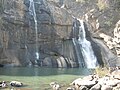 Hundru Falls
 -
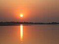 Sunset at Getalsud Dam
 -
 Radium Road at Kutchery Chowk
 -
 Kanke Dam, seen from Gonda hill


References
- ^ "Jharkhand Movement". Country Studies. Retrieved 2009-05-07. [dead link]
- ^ Cultural Configuration of Ranchi, Lalita Prasad Vidyarthi, Rajendra Behari Lal, India. Planning Commission. Research Programmes Committee, 1969, pg 306.
- ^ Journal and Proceedings of the Asiatic Society Of Bengal, Volume 4, No. 11, 1927, "The Etymology of Ranchi, pg 601.
- ^ Kaye's and Malleson's history of the Indian mutiny of 1857-8, Volume 4, By Sir John William Kaye, George Bruce Malleson, W.H. Allen, 1889, pg 95.
- ^ Falling Rain Genomics, Inc - Ranchi
- ^ Template:GR
External links
- Travel guide and more about Ranchi
- Template:Wikitravel
- Official website for Ranchi Municipal Corporation
- [7]
- Official website for Ranchi
- Ranchi's Artists Group
- Google Group for people connected to Ranchi
- Krishi Gram Vikas Kendra - Leading NGO of Ranchi
- Comprehensive guide to Ranchi
- Bit mesra
- Rajendra Institute of Medical Sciences
- [8][Xavier Institute of Social Services Ranchi]