
Santiago: Difference between revisions
m Tried to make some grammatical changes, but this article is too badly written to fix, in my opinion. |
|||
| Line 51: | Line 51: | ||
}} |
}} |
||
'''Santiago''' ({{Audio-es|Santiago de Chile|StgoEsp.ogg}}) is the [[capital]] city of [[Chile]] |
'''Santiago''' ({{Audio-es|Santiago de Chile|StgoEsp.ogg}}), also known as '''Santiago de Chile''', is the [[capital (political)|capital]] and largest city of [[Chile]], and the center of its largest [[conurbation]] ('''Greater Santiago'''). It is located in the country's [[Chilean Central Valley|central valley]], at an elevation of {{convert|520|m|2|abbr=on|lk=out}} [[above mean sea level]]. Although Santiago is the capital, [[National Congress of Chile|legislative bodies]] meet in the coastal town of [[Valparaíso]], a one-hour drive to its west. |
||
Chile's economic growth has transformed Santiago into one of [[Latin America]]'s most modern metropolitan areas, with extensive suburban development, dozens of shopping centers, and impressive high-rise architecture. It is an [[global city|Alpha(-) World City]] and has a very modern transport infrastructure, including the steadily growing underground [[Santiago Metro]], an effort at modernizing public bus transport and a [[free flow]] toll-based ring road and inner city highway system, part of which is tunneled underneath a large section of the city's main river [[Mapocho]] connecting the Eastern and Western extremes of the city in a 25-minute drive. |
Chile's steady economic growth has transformed Santiago into one of [[Latin America]]'s most modern metropolitan areas, with extensive suburban development, dozens of shopping centers, and impressive high-rise architecture. It is an [[global city|Alpha(-) World City]] and has a very modern transport infrastructure, including the steadily growing underground [[Santiago Metro]], an effort at modernizing public bus transport and a [[free flow]] toll-based ring road and inner city highway system, part of which is tunneled underneath a large section of the city's main river [[Mapocho]] connecting the Eastern and Western extremes of the city in a 25-minute drive. |
||
Santiago is the regional headquarters to many |
Santiago is the regional headquarters to many multinationals, and a financial center. Santiago has a [[cosmopolitian]] [[diverse]] culture. |
||
==Usage note== |
==Usage note== |
||
| Line 64: | Line 64: | ||
[[File:Fundacion de Santiago.jpg|thumb|1541 founding of Santiago]] |
[[File:Fundacion de Santiago.jpg|thumb|1541 founding of Santiago]] |
||
Santiago was founded by [[Pedro de Valdivia]] on February 12, 1541 |
Santiago was founded by Spanish [[Conquistador]] [[Pedro de Valdivia]] on February 12, 1541 with the name ''Santiago del Nuevo Extremo'', as a homage to [[James, son of Zebedee|Saint James]] and [[Extremadura]], Valdivia's birth place in [[Spain]].<ref>{{cite book|author = Luis de Cartagena | title = Actas del Cabildo de Santiago de 1541 a 1557th In Colección de Historiador de Chile y de documentos relativos a la historia nacional. Tomo 1st | publisher = Impr. del Ferrocarril | location = Santiago de Chile | year = 1861 - v. | url = http://www.memoriachilena.cl/temas/documento_detalle.asp?id=MC0018304 | page = 67}}</ref> The founding ceremony was held on Huelén Hill (later renamed ''[[Cerro Santa Lucía]]''). Valdivia chose the location of Santiago because of its climate, abundant vegetation and the ease with which it could be defended—the [[Mapocho River]] then split into two branches and rejoined further downstream, forming an island.<ref name="icarito">{{cite web|url = http://www.icarito.cl/medio/articulo/0,0,38035857_152309029_242338947,00.html|title = Llega Pedro de Valdivia al valle del Mapocho|publisher = Icarito}}{{Dead link|date=April 2010}}</ref> |
||
The [[Inca]] ruler Manco Cápac II warned the new rulers that his [[Indigenous peoples|Indigenous people]] would be hostile to the occupiers. The Spanish invaders had to battle against hunger caused by this resistance. Pedro de Valdivia ultimately succeeded in stabilizing the food supply and other resources needed for Santiago to thrive.<ref>{{cite book|author = De Ramón, Armando | title = Santiago de Chile (1541-1991). Historia de una sociedad urbana |publisher = Editorial Sudamericana | location = Santiago de Chile | year = 2000 | isbn = 956-262-118-9 | url = http://www.memoriachilena.cl//temas/documento_detalle.asp?id=MC0007069 | accessdate = 19 March 2009| page = 15f}}</ref> |
The [[Inca]] ruler Manco Cápac II warned the new rulers that his [[Indigenous peoples|Indigenous people]] would be hostile to the occupiers. The Spanish invaders had to battle against hunger caused by this resistance. Pedro de Valdivia ultimately succeeded in stabilizing the food supply and other resources needed for Santiago to thrive.<ref>{{cite book|author = De Ramón, Armando | title = Santiago de Chile (1541-1991). Historia de una sociedad urbana |publisher = Editorial Sudamericana | location = Santiago de Chile | year = 2000 | isbn = 956-262-118-9 | url = http://www.memoriachilena.cl//temas/documento_detalle.asp?id=MC0007069 | accessdate = 19 March 2009| page = 15f}}</ref> |
||
| Line 92: | Line 92: | ||
On 12 February 1817, the [[Battle of Chacabuco]] was fought in Colina, a short distance north of Santiago, where Argentine and Chilean independence armies, led by [[José de San Martín]] and [[Bernardo O'Higgins]], fought the Spanish royalists. That day, Chile proclaimed its independence. {{Citation needed|date=December 2009}} |
On 12 February 1817, the [[Battle of Chacabuco]] was fought in Colina, a short distance north of Santiago, where Argentine and Chilean independence armies, led by [[José de San Martín]] and [[Bernardo O'Higgins]], fought the Spanish royalists. That day, Chile proclaimed its independence. {{Citation needed|date=December 2009}} |
||
During the |
During the authoritarian era of the so-called Republic (from 1830 to 1891) the school system was introduced and cultural life started to flourish. In 1843 the [[Universidad de Chile]] was founded. In 1888 another university [[Pontificia Universidad Católica de Chile|Universidad Pontificia Católica]] was also founded. By 1885, 189,322 people were living in Santiago.<ref name=history/> |
||
===Nineteenth century=== |
===Nineteenth century=== |
||
| Line 122: | Line 122: | ||
[[File:Santiago de Chile 1930.jpg|thumb|Santiago in 1930]] |
[[File:Santiago de Chile 1930.jpg|thumb|Santiago in 1930]] |
||
The |
The 1930s saw the beginning of a transformation of the city into a modern, industrialized one. Surrounding the Presidential Palace ([[La Moneda]]) was the administrative district Barrio Cívico with many ministries and other public facilities. The population increased due to migration from northern and southern Chile and by the 1940s it had exceeded the milestone of a million inhabitants. Migration continued and by the year of 1960 Santiago's population had doubled to two million inhabitants.<ref name=Walter>{{cite book|url=http://books.google.com/books?id=2nwqWmZo_TYC&printsec=frontcover&dq=Politics+and+urban+growth+in+Santiago,+Chile&ei=WJ8dS6WEOZ-SygTHvZDgAw#v=onepage&q=&f=false |title=Politics and urban growth in Santiago, Chile, 1891-1941 By Richard J. Walter |publisher=Books.google.com |date= |accessdate=2010-04-17}}</ref> This fast increase in population led to poverty, especially in the poor neighborhoods of the city. |
||
===Santiago in the twentieth century and later=== |
===Santiago in the twentieth century and later=== |
||
Revision as of 08:02, 18 January 2011
Santiago | |
|---|---|
 Santiago de Chile. Clockwise: Santa Lucía Hill; Sanhattan; Titanium, currently the highest building in South America; Santiago's Metro stopping in a L1 station, La Moneda palace, Entel Tower. | |
 Location of Santiago commune in Greater Santiago | |
| Country | Chile |
| Region | Santiago Metropolitan Region |
| Province | Santiago Province |
| Foundation | February 12, 1541 |
| Government | |
| • Mayor | Pablo Zalaquett Said (UDI) |
| Area | |
| • Urban | 641.4 km2 (247.6 sq mi) |
| • Metro | 15,403.2 km2 (5,947.2 sq mi) |
| Elevation | 520 m (1,706 ft) |
| Population (2009) | |
| • City | 5,278,044 |
| • Density | 8,964/km2 (23,216/sq mi) |
| • Urban | 6,676,745 |
| • Metro | 7.2 Million |
| Time zone | UTC-4 (Chile Time (CLT)[1]) |
| • Summer (DST) | UTC-3 (Chile Summer Time (CLST)[2]) |
| Website | municipalidaddesantiago.cl |
Santiago (Spanish: ), also known as Santiago de Chile, is the capital and largest city of Chile, and the center of its largest conurbation (Greater Santiago). It is located in the country's central valley, at an elevation of 520 m (1,706.04 ft) above mean sea level. Although Santiago is the capital, legislative bodies meet in the coastal town of Valparaíso, a one-hour drive to its west.
Chile's steady economic growth has transformed Santiago into one of Latin America's most modern metropolitan areas, with extensive suburban development, dozens of shopping centers, and impressive high-rise architecture. It is an Alpha(-) World City and has a very modern transport infrastructure, including the steadily growing underground Santiago Metro, an effort at modernizing public bus transport and a free flow toll-based ring road and inner city highway system, part of which is tunneled underneath a large section of the city's main river Mapocho connecting the Eastern and Western extremes of the city in a 25-minute drive. Santiago is the regional headquarters to many multinationals, and a financial center. Santiago has a cosmopolitian diverse culture.
Usage note

In Chile there are several entities which bear the name of Santiago that are often confused: The Commune of Santiago (sometimes referred to as Santiago Centro, English: Downtown Santiago), is an administrative division that comprises roughly the area occupied by the city during its colonial period. The Commune of Santiago, which is administered by a city council and headed by a mayor, is part of the Santiago Province (headed by a Provincial Governor), which is itself a subdivision of the Santiago Metropolitan Region (headed by an Intendant). Still, throughout this article, and as it is widely accepted, the term Santiago will refer to what is commonly known as Greater Santiago (Spanish: Gran Santiago), a territorial extension defined by its urban continuity that includes the Commune of Santiago in addition to 36 other communes, which together comprise the majority of the Santiago Province and some areas of neighboring provinces (see Political divisions). The Greater Santiago inhabitants are called Santiaguinos/as.
History
Founding of the city

Santiago was founded by Spanish Conquistador Pedro de Valdivia on February 12, 1541 with the name Santiago del Nuevo Extremo, as a homage to Saint James and Extremadura, Valdivia's birth place in Spain.[3] The founding ceremony was held on Huelén Hill (later renamed Cerro Santa Lucía). Valdivia chose the location of Santiago because of its climate, abundant vegetation and the ease with which it could be defended—the Mapocho River then split into two branches and rejoined further downstream, forming an island.[4] The Inca ruler Manco Cápac II warned the new rulers that his Indigenous people would be hostile to the occupiers. The Spanish invaders had to battle against hunger caused by this resistance. Pedro de Valdivia ultimately succeeded in stabilizing the food supply and other resources needed for Santiago to thrive.[5]
The floor of the new town consisted of straight roads of 12 varas (14.35 m, 47.1 ft) width, in equal intervals of 138 varas (165.08 m, 541.6 ft) or perpendicular to each other. With nine roads in the east-west direction and 15 in the north-south direction, there were 126 Blocks that formed the so-called manzanas or square cut.[6]
Attempted destruction
The continued resistance of the indigenous population resulted in a series of further conflicts. On September 11, 1541 an organized uprising of Picunche and Michimalongo, led to an attack on Santiago, beginning a three-year-long war. At the time, the Conquistadores were in a very precarious situation, suffering persistent food shortages in almost complete isolation from the rest of the world.[7]
In January of 1542, Pedro de Valdivia sent an emissary, Alonso de Monroy, to Peru to request help. The Conquistadors suffered 20 harsh months until De Monroy returned from Peru with reinforcements, ending the isolation and demoralizing situation of the soldiers in Santiago. The uprising ultimately failed. The indigenous population moved South, and the city remained relatively safe.[7]
Colonial Santiago

Despite threats from Indian attack, earthquake, and flood, Santiago was rapidly settled.[citation needed] Of the 126 blocks designed by Gamboa in 1558, 40 had been occupied by 1580, while land nearby supported tens of thousands of head of livestock. These early settlers constructed the first important buildings in the city, most notably the first Cathedral (begun in 1561) and the Church of San Francisco (1919 each built mainly in adobe and stone.

In 1767, the corregidor Luis Manuel de Zañartu began one of the major architectural works of the entire colonial period in Chile: the Calicanto bridge, which helped unite the city.
In 1770, Governor Agustín de Jáuregui hired the Italian architect Toesca Joaquin, who designed, among other important works, the facade of the Cathedral and La Moneda. [8] The government of Ambrosio O'Higgins also opened the road to Valparaíso in 1791.
Independence

On 12 February 1817, the Battle of Chacabuco was fought in Colina, a short distance north of Santiago, where Argentine and Chilean independence armies, led by José de San Martín and Bernardo O'Higgins, fought the Spanish royalists. That day, Chile proclaimed its independence. [citation needed]
During the authoritarian era of the so-called Republic (from 1830 to 1891) the school system was introduced and cultural life started to flourish. In 1843 the Universidad de Chile was founded. In 1888 another university Universidad Pontificia Católica was also founded. By 1885, 189,322 people were living in Santiago.[7]
Nineteenth century


During the years of the Republican era, institutions were created primarily for educational use and they became planning examples of the period, as the University of Chile (Universidad de Chile), the Normal School of preceptors, the School of Arts and Crafts and the Quinta Normal, which included the Museum of Fine Arts (now Museum of Science and Technology) and the National Museum of Natural History. In 1851, the first telegraph system connecting the capital with the Port of Valparaiso was inaugurated.[7]
A new momentum in the urban development of the capital took place during the so-called "Liberal Republic" and the administration of the city's mayor, Benjamín Vicuña Mackenna. Among the main works during this period are the remodeling of the Cerro Santa Lucia which despite its central location was in very poor shape.[7]
In an effort to transform Santiago, Vicuña Mackenna began construction of the "Camino de Cintura" that surrounded the whole city, which until then had an extension similar to the current commune of Santiago. A new redevelopment of Alameda Ave. finally enshrined the central artery of the city.
With the work of European landscapes in 1873, O'Higgins Park opened. The park, with a public access, became an point of interest in Santiago due to the large gardens, lakes and carriages. Similarly, other important buildings were opened during this era, such as the Teatro Municipal which had many operas, and the Riding Club. At the same time, James received the International Exposition, held in 1875 in the grounds of the Quinta Normal. [9]

In terms of transport, the city became the main hub of the national railway system. The first railroad reached the city on September 14, 1857 in an emerging Central Station of Santiago, which would be opened permanently in 1884. During those years, the city was connected by rail to Valparaiso and rail crossing much of the country from north to south. With regards to urban transport, the streets of Santiago were paved and there were 1,107 cars in 1875. While 45,000 people used tram services on a daily basis.
Crisis, boom and immigration

The 1930s saw the beginning of a transformation of the city into a modern, industrialized one. Surrounding the Presidential Palace (La Moneda) was the administrative district Barrio Cívico with many ministries and other public facilities. The population increased due to migration from northern and southern Chile and by the 1940s it had exceeded the milestone of a million inhabitants. Migration continued and by the year of 1960 Santiago's population had doubled to two million inhabitants.[10] This fast increase in population led to poverty, especially in the poor neighborhoods of the city.
Santiago in the twentieth century and later


In the following decades, Santiago flourished and continued to grow rapidly.[10] In 1940 the city contained 952,075 inhabitants, rising to 1,350,409 in 1952 and reaching 1,907,378 by 1960 according to the census of that year.[10] This growth was reflected in the urbanization of rural areas on the periphery of the city, middle-class families settling into low and stable housing. In 1930 the urban area had an area of 6,500 hectares, increasing to 20,900 by 1960 and 38,296 by 1980. Although most of the communities continued to grow, it was mainly concentrated in outlying communities such as Canyon to the west, the north of the city and "Conchalí", "Las Cisternas" and "La Granja" to the south; the more wealthy sections of society became concentrated in areas such as Las Condes and La Reina. In contrast, the centre gradually decreased in population, leaving more space for the development of trade, banking and government activities.[11]
This growth took place without any regulation, this only beginning to be implemented during the 1960s with the creation of various development plans for Greater Santiago, reflecting the new reality of a much larger city. In 1958 a plan was launched in Santiago which proposed the organization of urban territory, setting a limit of 38,600 hectares for a maximum population of 3,260,000 inhabitants. New roads (such as the Avenida Américo Vespucio Ring-road and the Pan American highway) were constructed and existing industrial centers enlarged and new ones established. The hosting of the World Cup in 1962 gave new impetus to the improvement works of the city. In 1966 the Metropolitan Park of Santiago was established in the Cerro San Cristóbal and MINVU began eradicating shanty towns and construction of new homes and remodeling San Borja, which was built near the Diego Portales Building.[11]
The new International Airport Pudahuel opened in 1967 and, after years of discussion, in 1969 construction of the Metro de Santiago began, the first phase running under the western section of the Alameda and being inaugurated in 1975. The Metro was very successful and in subsequent years expanded, comprising two perpendicular lines by the end of 1978. Telecommunications have been an important development as reflected by the construction of the Torre Entel, which since its construction in 1975 would be one of the symbols of the capital and the tallest structure in the country for two decades.[11]
After the coup of 1973 and the establishment of the military regime, urban planning had no major changes until the beginning of 1980, when the government adopted a neoliberal economic model and took on the role of supervisor of a market economy. In 1979 the master plan was amended, extending the urban area to more than 62,000 hectares. Expansion has been particularly acute in La Florida where, according to the 1992 census, was the country's most populous municipality with 328,881 inhabitants. Meanwhile, a strong earthquake struck the city on March 3, 1985, causing few casualties but leaving many homeless and destroying many old buildings.[11] Another struck on February 27, 2010 leaving dozens dead.[12]
Economic crisis and recovery

Starting in 1981, Santiago (and Chile as a whole), went into a deep economic and financial crisis. The Chilean solution to the crisis was heterodox in the sense that many policies appeared to have been arbitrary, and policy mistakes were made and corrected along the way. However, the economy recovered relatively quickly, and since has built a strong financial sector that allowed the country to avoid the financial turmoil observed during 1995 and 1997-98 in other emerging market economies.[13] On Saturday, February 27, 2010 an 8.8 magnitude earthquake struck in central Chile, causing massive destruction in many places. However, because of good quality buildings, not much damage was recorded in Santiago.
Geography


The city lies in the centre of the Santiago Basin, a large bowl-shaped valley consisting of a broad and fertile plain surrounded by mountains. It is flanked by the main chain of the Andes on the east and the Chilean Coastal Range on the west. On the north, it is bound by the Cordón de Chacabuco, a transverse mountain range of the Andes, whereas at the southern border lies Angostura de Paine, where an elongated spur of the Andes almost reaches the Coastal Range. Santiago Basin is part of the Intermediate Depression and is remarkably flat, interrupted only by a few hills. Among those are Cerro Renca, Cerro Blanco and Cerro Santa Lucía.
The Andes mountains around Santiago are quite tall, culminating in Tupungato volcano at 6,570 m (21,555 ft). Other volcanoes include Tupungatito, San José and Maipo. Cerro El Plomo is the highest mountain visible from Santiago's urban area.
Santiago is situated mainly on a plain known as the Santiago basin. This basin is part of the Intermediate Depression and is clearly delimited by the string of Chacabuco in the north, the Andes Mountains in the east, the narrowness of Paine in the south and the Cordillera de la Costa. It is approximately 80 km in a north-south direction and 35 km from east to west.
For hundreds of millions of years, the current territory of the city was covered by the ocean and marine sediment, the only land mass near the existing Coastal Cordillera. The morphology of the region begin to take its present form since the late Paleozoic, when it begins the subduction of the Nazca Plate under the South American plate, then belonging to the continent of Gondwana. This subduction generated foldings of the crust from the Triassic, lifting the rocks that give rise to the Andes. Subsequently, new activities generate tectonic subsidence of the great rock mass forming the depression lifted.[14]
At present, Santiago lies mainly in the plain of the basin, with an altitude between 400 in the western areas and reaching the 540 on the Plaza Baquedano,[15] presented some hills in the area of Cerrillos. The metropolitan area has surrounded some of these islands, mountains, as in the case of Cerro Santa Lucia, Cerro Blanco, the Renca Calán and that 800 meters is the highest point of the city. Southwest of the city there is a string of rocky hills several islands within the highlighting Cerro Chena. To the west are also presented some of the main stage of the Cordillera de la Costa, the Oak Hill High with 2185 meters of altitude, and the Maipo River area alone in the mountain range loses height. During recent decades, urban growth has expanded the boundaries of the city to the east closer to the Andean Precordillera. Even in areas such as La Dehesa, Lo Curro and El Arrayan has been reached to overcome the barrier of 1000 meters of altitude.[16] Some low-lying foothills of the Andes emerge and goes into the basin, as is the If the mountain range of The Pyramid and the hill Cerro San Cristobal, in the northeastern sector of Santiago.
To the east, stands the massive call Ramon Sierra, a mountain chain formed in the foothills of the Precordillera due to the action of the fault Ramon, reaching 3296 meters at the Cerro de Ramon. 20 km further east is the Cordillera of the Andes with its mountain ranges and volcanoes, many of which exceed 6,000 m (19,685.04 ft) and in which some glaciers are maintained. The higher the Tupungato volcano with 6570 meters, [17] located near the volcano Tupungatito of 5913 meters of altitude. To the northeast lie Lead Hill (5,424 meters) and Nevado El Plomo 6070 meters in altitude. [17] To the southeast of the capital, meanwhile, are located on the Nevado Piuquenes (6,019 meters) volcano San Jose (5,856 m) and the volcano Maipo (5,323 m). From these peaks, the Tupungatito as San José and Maipo are active volcanoes.
Climate
Santiago has a somewhat cooler Mediterranean climate: relatively hot dry summers (November to March) with temperatures reaching up to 35 degrees Celsius (95 degrees Fahrenheit) on the hottest days; winters (June to August) are more humid with cold mornings, typical maximum daily temperatures of 13 degrees Celsius (56 degrees Fahrenheit), and minimums of a few degrees above freezing. Occasional snowfall occurs in the city, and may extend throughout the city, though this happens infrequently (about every 8–10 years). Mean rainfall is 360 mm per year and is heavily concentrated in the cooler months.
| Climate data for Santiago (1971-2000 period) | |||||||||||||
|---|---|---|---|---|---|---|---|---|---|---|---|---|---|
| Month | Jan | Feb | Mar | Apr | May | Jun | Jul | Aug | Sep | Oct | Nov | Dec | Year |
| Mean daily maximum °C (°F) | 29.7 (85.5) |
29.1 (84.4) |
26.9 (80.4) |
23.3 (73.9) |
18.7 (65.7) |
14.8 (58.6) |
13.6 (56.5) |
16.2 (61.2) |
19.0 (66.2) |
22.3 (72.1) |
25.4 (77.7) |
28.4 (83.1) |
22.5 (72.5) |
| Mean daily minimum °C (°F) | 13.0 (55.4) |
12.4 (54.3) |
10.7 (51.3) |
8.0 (46.4) |
6.3 (43.3) |
3.7 (38.7) |
1.7 (35.1) |
3.6 (38.5) |
6.1 (43.0) |
8.2 (46.8) |
10.1 (50.2) |
12.0 (53.6) |
8.3 (46.9) |
| Average precipitation mm (inches) | 0.4 (0.02) |
0.8 (0.03) |
3.2 (0.13) |
10.4 (0.41) |
42.2 (1.66) |
70.4 (2.77) |
86.6 (3.41) |
51.8 (2.04) |
22.0 (0.87) |
13.4 (0.53) |
9.2 (0.36) |
2.1 (0.08) |
312.5 (12.30) |
| Source: The World Meteorological Organization[17] | |||||||||||||


The climate of Santiago is a warm-temperate climate with winter rainfall and prolonged dry season, better known as continental Mediterranean climate.
Within the main climatic characteristics of Santiago is the concentration of about 80% of rainfall during the austral winter months (May to September), varying between 50 and 80 mm of rain fall during these months. That amount contrasts with figures for the months corresponding to a very dry season, caused by an anticyclonic dominance continued for about seven or eight months, mainly during the summer months between December and March. This season, the water drop does not exceed 4 mm on average. These rains are usually composed only of rain, as the snowfall and hail is produced mainly in the sectors of the Precordillera about 1500 meters, in some cases, nevazones affect the city but only on its eastern sectors, where in very rare opportunity extended to the rest of the city. [citation needed]
The temperatures vary throughout the year from an average of 20 °C (68 °F) in January to 8 °C (46 °F) in June and July. In the summer, January is hot, easily reaching over 30 °C (86 °F) and a record high close to 37 °C (99 °F), while nights are generally pleasant and slightly cooler without lowering of 15 °C (59 °F). For his part, during autumn and winter the temperature drops and is slightly lower than the 10 °C (50 °F), the temperature may even drop slightly from 0 °C (32 °F), especially during the morning, and its historic low of −6.8 °C (20 °F) in 1976. [citation needed]
Santiago's location within a watershed is one of the most important factors in the climate of the city. The coastal mountain range serves as a "screen climate" to oppose the spread of marine influence, contributing to the increase in annual and daily thermal oscillation (the difference between the maximum and minimum daily temperatures can reach 14°C) and maintaining low relative humidity close to an annual average of 70%. It also prevents the entry of air masses with the exception of some coastal low clouds that penetrate to the basin through the river valleys. [citation needed]
Prevailing winds are from the southwest direction, with an average of 15 km / h, especially during the summer as in winter calm prevail.
Environmental issues
Thermal inversion (a meteorological phenomenon whereby a stable layer of warm air holds down colder air close to the ground) causes high levels of smog and air pollution to be trapped and concentrate within the Central Valley during winter months. In the 1990s air pollution fell by about one-third, but there has been little progress since 2000.[18]
As of March 2007, only 61% of the wastewater in Santiago was treated,[19] which increased up to 71% by the end of the same year. However, the Mapocho River, which crosses the city from the north-east to the south-west of the Central Valley, remains contaminated by household, agricultural and industrial sewage, and by upstream copper-mining waste (there are a number of copper mines in the Andes east of Santiago), which is dumped unfiltered into the river.[20] Laws require industry and local governments to process all their wastewater, but are loosely enforced.[21] There are now a number of large wastewater processing and recycling plants under construction. There are ongoing plans to decontaminate the river[22] and make it navigable.[23]
Noise levels on the main streets are high,[24] mostly because of noisy diesel buses. Diesel trucks and buses are also major contributors to winter smog. A lengthy replacement process of the bus system began in 2005 and will last until 2010 (see Transport section below). However, a major source of Santiago air pollution year-round is the smelter of El Teniente copper mine.[25][26] Nevertheless, the government does not usually report it as being a local pollution source as it is just outside the reporting area of the Santiago Metropolitan Region, being 110 km. (70 miles) from downtown.[27][28]

Demographics


According to data collected in the 2002 census by the National Institute of statistics, the Santiago metropolitan area population reached 5.428.590 inhabitants, equivalent to 35.91% of the national total and 89.56 % of total regional inhabitants. This figure reflects broad growth in the population of the city during the 20th century: in 1907 had 383.587 inhabitants, 1.010.102 in 1940, 2.009.118 in 1960, 3.899.619 in 1982 and 4.729.118 in 1992.[29] (percentage of total population, 2007)[30]

The growth of Santiago has undergone several changes over the course of its history. In its early years, the city had a rate of growth 2.68% annually until the 17th century, then down to less than 2% per year until the early 20th century figures. The middle of this century was a demographic explosion explaining as, in its capacity as capital, absorbed on migration from mining camps in northern Chile during the crisis of the 1930s and from population from rural sectors between 1940 and 1960, mainly. Lots of migration coupled with the high fertility rate at that time were reflected in figures annual growth reached 4.92% between 1952 and 1960. However, since the end of this century, growth figures been reduced again, reaching 1.35% in the early 2000s. Similarly, the size of the city expanded constantly. The 20,000 hectares covering Santiago in 1960, doubled by 1980 and in 2002 reached 64.140 hectares. Thus the density of population in Santiago is 8.463,7 inhabitants/Km².
The population of Santiago[29] has been booming over the years. For 2007, it is estimated that 32.89 per cent of men and 30.73% of women were less than 20 years old, while 10.23% and 13.43% were over 60 years, respectively. In contrast, in 1990 the figure under 20 years in total was 38.04 % and over 60, 8.86%. For the year 2020 is estimated that both figures will be 26.69% and 16.79%.
4,313,719 people in Chile say they were born in one of the communes of Grand Santiago[29] according to the 2002 census what amounts to 28.54% of the national total. Of the current inhabitants of Santiago, 67.6% were born in the communes of the metropolitan area. 2.11% of the inhabitants are illegal immigrants.
Economy


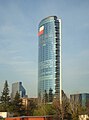
Santiago is the industrial and financial centre of Chile, and generates 45% of the country's GDP.[31] Some international institutions, such as ECLAC (Economic Commission for Latin America and the Caribbean), have their offices in Santiago. Currently under construction is the Costanera Center, a mega project in Santiago's Financial District. This includes a 280,000-square-metre (3,000,000 sq ft) mall, a 300-meter (980 ft) tower, two office towers of 170 meters (558 ft) each, and a hotel 105 meters (344 ft) tall. When completed in 2012 it will be the tallest building in Latin America. In January 2009 the retailer in charge, Cencosud, said in a statement that the construction of the mega-mall would gradually be reduced until financial uncertainty is cleared.[32] In January 2010, Cencosud announced the re-start of the project, and this was taken generally as a symbol of the country's success over the global financial crisis. Close to Costanera Center another skyscraper is already in use, Titanium La Portada, 190 meters (623 ft) tall. Although these are the two biggest projects, there are many other office buildings under construction in Santiago, as well as hundreds of high rise residential buildings.
Industry


Santiago is Chile’s major industrial and agricultural region. The bulk of Chile’s industrial and commercial activity is concentrated in the national and regional capital of Santiago, but there are important farm-supply, marketing, and processing activities at San Bernardo (location of major railroad shops), Puente Alto (a paper- and gypsum-processing centre), Melipilla, Talagante, and Buin. Dairying and beef production are significant; the main crops are grains, grapes, potatoes, and beans. Copper, gypsum, and limestone are mined. Marketing is facilitated by the proximity of urban centres, by main-line railroad communications, and by the best-developed regional road system in Chile.
Commerce
Santiago is Chile's retail capital. Falabella, Paris, Mega Johnsons, Ripley, La Polar and several other department stores dot the mall landscape of Chile. The east side neighborhoods like Vitacura, La Dehesa, and Las Condes are home to Santiago's swanky Alonso de Cordova street and malls like Parque Arauco and Alto Las Condes, all known for their luxurious shopping scene. Alonso de Cordova is Santiago's equivalent to Rodeo Drive or Avenida Masaryk in Mexico City, with exclusive stores like Louis Vuitton, Hermes, Emporio Armani, Salvatore Ferragamo, Ermenegildo Zegna, MaxMara, Longchamp, and many more stores that carry exclusive brands. Alonso de Cordova also houses some of Santiago's most famous restaurants, art galleries, wine showrooms and furniture stores. There are also plans for a Saks Fifth Avenue in Santiago. For a more bohemian scene the are several mercados in the city that sell local goods and Bellavista where some of the most exclusive nigh clubs and chic cafes are located.
Transport
Air
.JPG)
Comodoro Arturo Merino Benítez International Airport is Santiago's national and international airport. 15 minutes from downtown through the urban highways (Costanera Norte-Vespucio Norte). The airport currently serves non-stop flights from Santiago to the United States via Miami, Dallas, Los Angeles, New York and Atlanta.[33]
Rail

Trains operated by Chile's national railway, Empresa de los Ferrocarriles del Estado, connect Santiago to Chillan, in the central-southern part of the country. All such trains arrive and depart from the Estación Central ("Central Station") which can be accessed by bus or subway.[34]
The routes and coverage are from:
- Santiago–San Fernando.
- Santiago–Chillán.
- Talca–Constitución.
- Talcahuano–Hualqui.
- Talcahuano–Renaico.
- Victoria–Temuco.[35]
Inter-urban buses
Bus companies provide passenger transportation from Santiago to most areas of the country, while some also provide parcel-shipping and delivery services. There are several bus terminals in Santiago:
- Terminal San Borja: located near the Metro station "Estación Central", where also depart train services to Rancagua, Talca and Chillán.
- Terminal Los Heroes: located near the Metro station "Los Héroes"
- Terminal La Paz: located in the municipality of Independencia, the closest Metro station is "Puente Cal y Canto"
- Alameda Interchange: located near the Metro station "Universidad de Santiago",[36] from here depart a veriety of bus services to the south of Chile.
- Pajaritos Interchange: located in the same name Santiago Metro station, provides bus services to the international airport, inter-regional services to Valparaíso, Viña del Mar and several other coastal cities and towns.
Highways
Toll road, inter-urban free flow highways connect the city's extremes, including the Vespucio Highway (which surrounds the city describing a semicircle), Autopista Central (which crosses the city in a North-South direction), and the Costanera Norte (which runs from the eastern edge, in Las Condes to the international airport and the highways to Valparaíso on the western side of the city).
Public transport


Santiago has 37.32% of Chile's vehicles, with a total of 991,838 vehicles, 979,346 of which are motorized. 805,220 cars pass through the city, which is equivalent to 37.63% of the national and at a rate of one car for every 7 people.[citation needed] To support this huge number of cars there is an extensive network of streets and avenues stretching across Santiago to facilitate travel between the different communities that make up the metropolitan area.
As regards public transport, during the 1990s various governmental efforts were attempted to resolve what was considered a chaotic system in the city. There were tendered in 1994 for the first time for the routes of the yellow buses (minibuses identified with the colour). [citation needed] Despite this, the system had serious issues of routes overlapping, contamination and unsafety for riders, and therefore a new transport system, called Transantiago was devised. The system was launched on February 10, 2007, combining core services across the city with a local feeder routes, which have a unified system of payment through a contactless smartcard called "Tarjeta bip!". In its first months, Transantiago showed a series of errors in design and implementation, which lately have been majorly resolved by the authorities.[37] However, a high rate of evasion of fare payment, and some frequency issues in certain areas remain as of August 2010.
Metro de Santiago carries over 2 million passengers daily through its five lines (1, 2, 4, 4A and 5), extending over 84 km and 89 stations. By the end of 2010, a new extension to the commune of Maipú will make Metro expand to more than 105 km in length. Construction of two new lines (3 and 6) was confirmed recently by president Sebastián Piñera, and is expected to be operating in 2014.[38]
Other local transport systems include 25,000 taxis[citation needed], identified by black colour cars and yellow roof. In regard to cycling, in recent years the city has tried to promote the use of bicycles with the construction of bike paths and bike lanes, but so far the number built is limited and with little connections between the routes. Most cyclists ride on the street, and the use of helmets and lights is not extended.
Metro


With 101 stations currently in operation and 16 under construction, the Santiago Metro is South America's most extensive metro system. The system has five operating lines and carries around 2,400,000 passengers per day. Two underground lines (Line 4 and 4A) and an extension of Line 2 were inaugurated during late 2005 and beginning of 2006.[39] Further extensions are currently underway on Lines 1 and 5.[40] An announcement of plans for a new line was made by President Bachelet. The South Express Line, Line 6, will be finished by 2014, adding 12 stations to the network and approximately 15 km of track.[40]
Commuter Rail
The company Trenes Metropolitanos S.A. provides suburban rail service under the brandname of Metrotren. There is only one southbound route, serving 18 stations between the Central Station of Santiago at Alameda and San Fernando, via Paine and Graneros. The electrified service expands over 138 km (85.75 mi). About 10 daily trains operate the full distance in each direction, with up to 30 trains between Santiago and Graneros.[41]
Bus
Transantiago is the name for the city's public transport system. It works by combining local (feeder) bus lines, main bus lines and the Metro network. It includes an integrated fare system, which allows passengers to make bus-to-bus or bus-to-metro transfers for the price of one ticket, using a contactless smartcard. Fares cannot be paid in cash, and if the card have not enough credit, must be recharged before a trip.
Taxi
Taxicabs are common in Santiago and are painted black with yellow roofs and have orange license plates. So-called radiotaxis may be called up by telephone and can be any make, model, or color but should always have the orange plates. Colectivos are shared taxicabs that carry passengers along a specific route for a fixed fee. Santiago also has some illegal taxis without the orange plates indicating proper licensing. These are especially common near the airport and should generally be avoided for safety.
Political divisions
Greater Santiago lacks a metropolitan government for its administration, which is currently distributed between various authorities, complicating the operation of the city as a single entity.[42] The highest authority in Santiago is considered to be the intendant of the Santiago Metropolitan Region, an unelected delegate of the president.
The whole of Greater Santiago does not fit perfectly into any administrative division, extending throughout four different provinces and 37 communes. The majority of its 641.4 km2 (247.65 sq mi) (as of 2002)[43] lie within Santiago Province, with some peripheral areas contained in the provinces of Cordillera, Maipo and Talagante.
.svg)
Culture


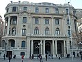
Despite the long history, there are only a few historical buildings from the Spanish colonial period in the city, because Santiago - as the rest of the country - was regularly hit by earthquakes. The buildings from this period include the Casa Colorada (1769), the Church San Francisco (1586) and Posada del Corregidor (1750). Another reason that it lacks old buildings from this time is the new richness of Chile. At the time of the Spanish colony, the city had economically only a low impact, the upswing was only after independence. This explains the low age of many buildings built mainly in neoclassic style. The Cathedral on the central square (Plaza de Armas), 1745 according to plans by Joaquim Toesca built, ranks as the sights as Palacio de La Moneda, the Classicist Presidential Palace. The original building was between 1784 and 1805 of the architect Joaquín Toesca. Since 1846, the Presidential Palace is home to the Government.

Other buildings at the Plaza de Armas are finished on 1882 and between 1804 and 1807 built Palacio de la real Audjencia, of 18. September 1810 - today date of Nationalfeiertages - met the first Government of the country. The Centre houses the historical museum with 12,000 exhibits. In the South-East of the square is the built in 1893 blue Eisenkontruktion of Edwards Kaufhauses (Edificio commercial Edwards) and the 1769 finished colonial building the "Casa Colorada", the historical city museum Close is the (Teatro Municipal) Theatre. In 1906 by an earthquake destroyed building was built of the French architect Brunet of Edward Baines 1857. Not far from the theatre the Mansión Subercaseaux (today seat Banco Edwards) and the National Library (one of the largest libraries of South America). Grouped opposite are the previous National Convention, the law courts, and the Royal Customs House (Palacio real Casa de Aduana), together with the Museum of pre-Columbian art.

A fire destroyed the building in 1895. It was then rebuilt and reopened 1901 in neoclassic style. The first Chilean National Congress was 4. July 1811 decision (1810) the Government junta in Santiago formed by. The Congress was deposed under the military dictatorship of Augusto Pinochet (1973–1989) and after the dictatorship in Valparaíso on 11. Newly constituted March 1990. The Plaza Montt is the building of the Justice Palace (Palacio de Tribun Musicales). The building was between 1907 and 1926 of the architect Emilio Doyére. It is home to the Supreme Court (Corte comparison de Justicia). The Kollegialgericht with 21 judges is the highest judiciary in Chile. The judges be proposed by the judges of the Supreme Court and appointed by the President on lifetime. The building is also home of the Supreme Court of appeal.
At the Plaza Montt is the building of the Justice Palace (Palacio de Tribunales). The building was created from 1907 to 1926 after plans by the architect Emilio Doyére. It is the seat of the Supreme Court (Corte Suprema de Justicia). The panel of 21 judges is the highest judicial power in Chile. The judges are appointed by the judges of the Supreme Court and proposed by the President appointed for life. The building is also headquarters of the Supreme Court of the country.


Calle Bandera ("Banner Street") leads to the building of the Merchants' Exchange (the Bolsa de Comercio), completed in 1917, to the Club de la Unión (its building was opened in 1925), to the Universidad de Chile (1872), and to the oldest churchhouse in the city, the Iglesia de San Francisco (constructed between 1586 and 1628), with its Marian statue, La Virgen del Socorro ("The Virgin of Succour"), by Pedro de Valdivia. North of the Plaza de Armas ("Place of Arms", where the colonial militia was mustered), the Paseo Puente to Santo Domingo Church (1771) and Market (Mercado Central), a powerful iron construction. In the centre of Santiago is the Torre Entel, a 127.4-meter-high television tower with observation deck, all completed in 1974; the tower serves as a communication center for the leading telephone company, ENTEL Chile.
With the Costanera Center, a commercial and architectural landmark of the capital. When completed in 2009 is a combination of jobs, housing, shopping and entertainment venues have been achieved. The project with a total area of 600,000 square meters, includes the 300-meter high "Gran Torre Costanera" (South America's tallest building) and three other commercial buildings with shopping malls, shops, cinemas, an amusement centre, restaurants, hotels, offices and luxury apartments. The four office towers extensive building complex is replaced by a highway and subway connections.[44]
Music
There are two symphonic orchestras:
- Orquesta Filarmónica de Santiago ("Philharmonic Orchestra of Santiago"), which performs in the Teatro Municipal ("Municipal Theater")
- Orquesta Sinfónica de Chile ("Symphonic Orchestra of Chile"), dependent of the Universidad de Chile, performs in its theater.
There are a number of jazz establishments, some of them, including "El Perseguidor", "Thelonious", and "Le Fournil Jazz Club", are located in Bellavista, one of Santiago's "hippest" neighborhoods, though "Club de Jazz de Santiago", the oldest and most traditional one, is in Ñuñoa.[45]
Newspapers
The most widely circulated newspapers in Chile are published by El Mercurio and Copesa and have earned more than the 901% of revenues generated in printed advertising in Chile.[46]
Some of the most popular newspapers available in Santiago are:
Sports
Santiago is home of Chile's most successful football clubs. The most successful of them is Colo Colo. It was founded on April 19, 1925. It has a long tradition and plays since the establishment of the first Chilean league in 1933 continuously in the highest league. 29 national titles, 10 Copa Chile successes and in 1991 champions of Copa Libertadores, Chile's only team that ever won the tournament. The club hosts its home games in the Estadio Monumental, in the commune of Macul.
Another great club is CF Universidad de Chile. The club is considered one of the best known and most successful with 13 national titles and 3 Copa Chile successes. It was founded on May 24, 1927 under the name Club Deportivo Universitario as a union of Club Náutico and Federación Universitaria. The founders were students of the Universidad de Chile. 1980, the organization separated from the University of Chile and the club is now completely independent. The team plays its home games in the Estadio Nacional de Chile, in the commune of Ñuñoa.

Club Deportivo Universidad Católica was founded on April 21, 1937 and is also often referred to briefly as UC. It consists of fourteen different departments responsible for the students of the same university are excluded. Far beyond the borders of Chile is known mainly for his club soccer team. This team plays its home games in Estadio San Carlos de Apoquindo. Universidad Católica has 9 national titles, making it the third most successful football club in the country. It has played the Copa Libertadores more than 20 times, reaching the final in 1993, losing to São Paulo FC.
Several other football clubs are based in Santiago, the most important of them being Unión Española, Audax Italiano, Palestino and Santiago Morning.
In addition to playing football in particular tennis and horse riding (here especially the Chilean Rodeo) plays an important role. In the entire metropolitan area are distributed Wettstuben in which mainly the male population of Santiago, the horse racing track at screens. [citation needed] Completed the 1904 Club Hípico is located in the south of the city.
Recreation
There is an extensive network of bicycle trails in the city, especially in the Providencia comuna. The longest section is the Americo Vespuccio road, which contains a very wide dirt path with many trees through the center of a street used by motorists on both sides. The next longest path is along the Mapocho River along avenida Andrés Bello.
The city's main parks are:
- Cerro San Cristóbal - San Cristóbal Hill, which includes the Santiago Metropolitan Park Zoo
- Parque O'Higgins - O'Higgins Park
- Parque Forestal - Forestal Park, park located at the city centre alongside Mapocho river
- Cerro Santa Lucía - Santa Lucía Hill
- Parque Araucano in Las Condes adjacent to the Parque Arauco shopping mall contains 30 hectares of gardens. It is closed for maintenance on Mondays.
- Parque Inés de Suarez, Providencia.
- Parque Padre Hurtado(a.k.a. Parque Intercomunal).
There are ski resorts to the east of the city (Valle Nevado, La Parva) and wineries in the plains west of the city.
Cultural places to visit include:
- Museo de Bellas Artes - Fine Arts Museum
- Barrio Bellavista, cultural and bohemian neighborhood
- Central Station, railway station designed by Gustave Eiffel
- Víctor Jara Stadium
- Ex National Congress
- Plaza de Armas, central square
- Palacio de La Moneda, government palace
The main sport venues are Estadio Nacional (site of the 1962 World Cup final), Estadio Monumental David Arellano, Estadio Santa Laura and Estadio San Carlos de Apoquindo.
Religion

As in most of Chile, the majority of the population of Santiago is Catholic. According to the National Census, carried out in 2002 by the National Statistics Bureau (INE), in the Santiago Metropolitan Region, 3,129,249 people 15 and older identified themselves as Catholics, equivalent to 68.7% of the total population, while 595,173 (13.1%) described themselves as Evangelical Protestants. Around 1.2% of the population declared themselves as being Jehovah's Witnesses, while 0.9% identified themselves as Latter-day Saints (Mormons), 0.25% as Jewish, 0.11% as Orthodox and 0.03% as Muslim. Approximately 10.4% of the population of the Metropolitan Region stated that they were atheist or agnostic, while 5.4% declared that they followed other religions.[48]
Education

The city is home to numerous universities, colleges, research institutions and libraries.
The Pontificia Universidad Católica de Chile (PUC) was founded in June 1888. On 11 February 1930 was the university by a decree by Pope Pius XI. to an appointed Pontifical University, 1931, the full recognition by the Chilean government. Joaquín Larraín Gandarillas (1822–1897), Archbishop of Anazarba, was the founder and first rector of the PUC. The PUC is a modern university; the campus of San Joaquin has a number of contemporary buildings and offers many parks and sports facilities. Several courses are conducted in English. The current president Sebastián Piñera, minister Ricardo Raineri, and minister Hernán de Solminihac all attended PUC as students and worked in PUC as professors. In the 2010 admission process, approximately 48% of the students who achieved the best score in the Prueba de Selección Universitaria matriculated in the UC.[49]

The largest university and one of the oldest on the American continent is Universidad de Chile. The roots of the University date back to the year 1622, as on 19 August the first university in Chile under the name of Santo Tomás de Aquino was founded. On 28 July 1738, it was named the Real Universidad de San Felipe in honor of King Philip V of Spain. In the vernacular, it is also known as Casa de Bello (Spanish: Bellos house - after their first Rector, Andrés Bello) known. On 17 April 1839, after Chile from the mother country, the Kingdom of Spain, became independent, was officially to the University Universidad de Chile, and opened on 17 September 1843.
Higher education
Traditional
- Universidad de Chile (U or UCH)
- Pontificia Universidad Católica de Chile (PUC)
- Universidad de Santiago de Chile (USACH)
- Universidad Metropolitana de Ciencias de la Educación (UMCE)
- Universidad Tecnológica Metropolitana (UTEM)
- Universidad Técnica Federico Santa María (UTFSM)
Non-traditional
- Universidad Academia de Humanismo Cristiano (UAHC)
- Universidad Adolfo Ibáñez (UAI)
- Universidad Alberto Hurtado (UAH)
- Universidad Bolivariana
- Universidad Católica Raúl Silva Henríquez
- Universidad Central de Chile
- Universidad de Artes y Ciencias Sociales (Arcis)
- Universidad de Artes, Ciencias y Comunicación (UNIACC)
- Universidad de Ciencias de la Informática (UCINF) [www.ucinf.cl/]
- Universidad de las Américas
- Universidad de Los Andes
- Universidad del Desarrollo
- Universidad del Pacífico
- Universidad Diego Portales
- Universidad Europea de Negocios
- Universidad Finis Terrae
- Universidad Gabriela Mistral (UGM)
- Universidad Mayor (UM) [2]
- Universidad Nacional Andrés Bello (Unab)
- Universidad Pedro de Valdivia (Upv)
- Universidad Santo Tomás
- Universidad San Sebastián
- Universidad Tecnológica Vicente Pérez Rosales
- Instituto profesional DuocUC, de la Pontificia Universidad Catolica de Chile, DuocUC, [3], es:DuocUC
- Instituto profesional INACAP
Other
- Ruprecht Karl University of Heidelberg's Postgraduierten- und Weiterbildungszentrum der Universität Heidelberg in Santiago
- David Rockefeller Center for Latin American Studies (DRCLAS) Regional Office in Santiago
- Stanford Faculty in Santiago
International relations
Twin towns — Sister cities
Santiago is twinned with:
Partner city
Gallery
-
 Club de La Unión
 -

-

-
-

-
 Paseo bulnes
 -
 Paseo ahumada
 -
 Vitacura
 -
 Alameda
 -
 Entel tower
 -
Santiago
-
Santiago
-
Plaza a la Aviacion


References
- Notes
- ^ "Chile Time". World Time Zones .org. Retrieved 2007-05-05.
- ^ "Chile Summer Time". World Time Zones .org. Retrieved 2007-05-05.
- ^ Luis de Cartagena (1861 - v.). Actas del Cabildo de Santiago de 1541 a 1557th In Colección de Historiador de Chile y de documentos relativos a la historia nacional. Tomo 1st. Santiago de Chile: Impr. del Ferrocarril. p. 67.
{{cite book}}: Check date values in:|year=(help) - ^ "Llega Pedro de Valdivia al valle del Mapocho". Icarito.[dead link]
- ^ De Ramón, Armando (2000). Santiago de Chile (1541-1991). Historia de una sociedad urbana. Santiago de Chile: Editorial Sudamericana. p. 15f. ISBN 956-262-118-9. Retrieved 19 March 2009.
- ^ De Ramón, Armando, 2000, p. 17
- ^ a b c d e A history of Chile. Books.google.com. 2007-08-16. Retrieved 2010-04-17.
- ^ Ayarza Elorza, Hernán. "Historia in engineering: the embankments Mapocho" (PDF). Engineering Magazine. Retrieved 2007-12-16.
- ^ Martín (2007-05-29). "Past, present, and future images of a "green space" in the metropolitan area of Santiago". Revista Urbanismo, Nº3.
{{cite web}}: Check date values in:|year=/|date=mismatch (help) - ^ a b c Politics and urban growth in Santiago, Chile, 1891-1941 By Richard J. Walter. Books.google.com. Retrieved 2010-04-17.
- ^ a b c d "Santiago de Chile, ¿ejemplo de una reestructuración capitalista global?". Scielo.cl. 1990-01-06. Retrieved 2010-04-17.
- ^ Soto, Alonso (February 27, 2010). "Massive earthquake kills 82 in Chile". http://www.reuters.com. Retrieved 27 February 2010.
{{cite web}}: External link in|publisher= - ^ "ORIGINS AND RESOLUTION OF A BANKING CRISIS: CHILE 1982-86" (PDF). Retrieved 2010-04-17.
- ^ Turiscom (2002). Guía Turística Turistel - Zona Centro. Santiago: Turismo y Comunicaciones S.A. ISBN 956-7264-81-3.
- ^ Pontificia Universidad Católica de Chile (2001). "Contaminación atmosférica. Casos de estudio: Santiago de Chile". Retrieved 2007-06-24.
- ^ Peaklist (2007). "Argentina and Chile Central, Ultra-Prominences". Retrieved 2007-06-24.
- ^ "Weather Information for Santiago". Retrieved Feb 2010.
{{cite web}}: Check date values in:|accessdate=(help) - ^ Pamela Morales. "Chilean University Finds Santiago Pollution Has Doubled". The Santiago Times. Retrieved 2010-01-27.
- ^ Revista Ecoamérica. "Cruzada ambiental por el Mapocho limpio" (in Spanish). Retrieved 2008-02-11.
permitirá pasar del 68 al 81% en el tratamiento de las aguas servidas
- ^ El Mercurio. "Región Metropolitana saneará el 100% de aguas servidas al 2010" (in Spanish). Fundación Terram. Retrieved 2008-02-11.
- ^ Comisión Regional Metropolitana del Medio Ambiente. "Agua, Recurso Escaso y Vital" (in Spanish). Archived from the original on 2008-07-28. Retrieved 2008-11-02.
se calcula que sólo el 77% de las industrias del país cumple con la norma de RILES existente
- ^ "Mapocho urbano limpio: El río soñado" (PDF). Archived from the original (PDF) on June 25, 2008. Retrieved 2008-11-02.
Proyecto Mapocho Urbano Limpio
- ^ Fundación Futuro. "Proyecto Mapocho" (in Spanish).
- ^ Comisión Regional Metropolitana del Medio Ambiente. "Ruidos molestos en Santiago" (in Spanish). Archived from the original on 2008-01-17. Retrieved 2008-02-11.
cerca de un 70% de la población santiaguina está expuesta a serias interferencias de su sueño por ruido que excede 65 dB
- ^ "Cipma.cl" (PDF). Retrieved 2010-04-17.
- ^ "Bio.puc.cl". Retrieved 2010-04-17.
- ^ Pedro Oyola. "the role of monitoring in air quality management" (PDF).
- ^ "Conoma.cl". Conama.cl. 2008-05-14. Retrieved 2010-04-17. [dead link]
- ^ a b c Se consideran en total las comunas de la Provincia de Santiago, más Padre Hurtado, Pirque, Puente Alto y San Bernardo. Estas cifras no son equivalentes a la de la ciudad de Santiago pues excluyen ciertas áreas fuera de dichas comunas e incluyen algunas zonas rurales; sin embargo, representa a un 95,4% de la población total del área metropolitana.
- ^ INE. "Chile, proyecciones de población al 30 de junio (1990-2020): Región Metropolitana de Santiago" (XLS). Retrieved 2007-12-23.
- ^ "Santiago.cl". Santiago.cl. Retrieved 2010-04-17.
- ^ "Reuters.com". In.reuters.com. 2009-01-29. Retrieved 2010-04-17.
- ^ LAN AirlinesDelta AirlinesAmerican Airlines
- ^ Transantiagoinforma.cl Transantiago Info /
- ^ EFE.cl[dead link] Chilean Railways Information
- ^ Terminaldebusessantiago.cl Terminal de buses Santiago
- ^ http://www.plataformaurbana.cl/archive/2009/02/10/expertos-y-pasajeros-reconocen-mejoras-en-transantiago-a-dos-anos-del-inicio/
- ^ http://www.latercera.com/noticia/nacional/2010/10/680-297040-9-pinera-anuncia-construccion-de-dos-nuevas-lineas-del-metro-para-2014.shtml
- ^ "Railway-technology.com". Railway-technology.com. Retrieved 2010-04-17.
- ^ a b "Metrosantiago.cl". Metrosantiago.cl. Retrieved 2010-04-17.
- ^ "Website Metroten Santiago". Tmsa.cl. Retrieved 2010-04-17.
- ^ Pontificia Universidad Católica de Chile (2004), Boletín de Políticas Públicas: Una autoridad metropolitana para Santiago[dead link]
- ^ Alexander Galetovic; Pablo Jordán (Summer 2008). "Santiago: ¿Dónde estamos?, ¿Hacia dónde vamos?" (PDF) (in Spanish). Estudios Públicos.
{{cite web}}: CS1 maint: multiple names: authors list (link) - ^ Emporis: Gran Torre Costanera
- ^ Chile’s Best Known Bohemian Outpost - Bellavista – Bursting With New Activity, Santiago Times
- ^ Torta para dos ¿Hasta cuando?, elciudadano.cl
- ^ Template:En icon SantiagoTimes.cl
- ^ "INE, Chile, 2002 Census". Ine.cl. Retrieved 2010-04-17.
- ^ [1]
- ^ Prefeitura.Sp - Descentralized Cooperation
- ^ "International Relations - São Paulo City Hall - Official Sister Cities". Prefeitura.sp.gov.br. Retrieved 2010-04-17.
- ^ "Twin cities of Riga". Riga City Council. Retrieved 2009-07-27.
- ^ "Sister Cities of Manila". © 2008-2009 City Government of Manila. Retrieved 2009-09-02.
{{cite web}}: External link in|publisher=
External links
- Municipality homepage
- Santiago Tourist - An Independent Travel Guide
- Ameristar Chile Travel and Living in Chile
33°26.27′S 70°39.02′W / 33.43783°S 70.65033°W
| Santiago |
|  |
|---|---|---|
| Chacabuco | ||
| Cordillera | ||
| Maipo | ||
| Melipilla | ||
| Talagante | ||