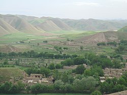
Badghis Province
Badghis
بادغیس | |
|---|---|
Province of Afghanistan | |
 Location within Afghanistan | |
 Districts prior to 2005 realignment | |
| Country | |
| Provincial seat | Qala i Naw |
| Districts | |
| Government | |
| • Governor | Enayatullah Enayat |
| Area | |
| • Total | 20,591 km2 (7,950 sq mi) |
| • Water | 0 km2 (0 sq mi) |
| Population | |
| • Total | 499,393 |
| • Density | 20.9/km2 (54/sq mi) |
| Ethnic groups | |
| • | Tajiks |
| •  : | Pashtuns |
| • | Uzbeks |
| • | Turkmen |
| Languages | |
| • | Dari Persian Pashto Turkmen |
| ISO 3166-2 code | AF-BDG |
Bādghīs (Persian: بادغیسLap of Wind) is one of the thirty-four provinces of Afghanistan. It is located in northwestern Afghanistan, between the Murghab and Hari rivers, extending as far northward as the edge of the desert of Sarakhs. The province was carved out of portions of Herat and Meymaneh provinces in 1964 and has a total area of 20,591 km².[2] Its name is from Persian word Bādkhīz (بادخیز) meaning "where the winds arise" or "home of the winds".
History
The name "Badghis" is from the Pashto word Bādghezz (باد غېږ) meaning "lap of wind" or "home of the winds". The province was one of the last captured by the Taliban in their military offensive before the American invasion in 2001. Even after their official takeover of the province, the largely Tajik population of the province never welcomed the Pashtun Taliban. The province was quickly retaken by Northern Alliance forces as the United States initiated hostilities, which was followed by a brutal cleansing of the Pashtun minority in the province.
Various influential warlords have traded control of the province in recent years, including: Abdul Malik, Rashid Dostum, Juma Khan and Ismail Khan. During the fight against the Taliban, the Northern Alliance commanders received military aid from Shia Iran, fearful of the Sunni Taliban. In one notable incident, Malik temporarily switched his allegiances from Dostum, allowing the Taliban to gain control of the province.
Demography
Persian speaking Tajiks (including Hazara and Chahar Aimaks) are 56% of the population, and Pashtuns are 40% of the population, followed by a 4% of Uzbeks, Turkmens and Balochs.[3][4] According to AIMS and NPS, the population of Badghis consists of 62% Tajik, 28% Pashtun, 5% Uzbek, 3% Turkmen, and 2% Baloch.[5] It is counted as one of the most underdeveloped of the country's 34 provinces. Qala i Naw, a small town half-way between Sheberghan and Herat serves as the provincial center.
Politics
The current Governor of the province is Enayatullah Enayat.
At the province is a Provincial Reconstruction Team, which is led by Spain.
Districts

|
| District | Capital | Population[6] | Area[7] | Notes | |
|---|---|---|---|---|---|
| km² | sq mi | ||||
| Ab Kamari | Sang Atesh | 81,843 | 1,817 km2 | 702 sq mi | |
| Ghormach | Ghormach | 52,566 | Created in 2004 within Murghab District | ||
| Jawand | 77,635 | 7,146 km2 | 2,759 sq mi | ||
| Muqur | 20,480 | 1,133 km2 | 437 sq mi | ||
| Murghab | Murghab | 109,381 | 4,491 km2 | 1,734 sq mi | |
| Qadis | Qadis | 88,139 | 3,385 km2 | 1,307 sq mi | |
| Qala i Naw | Qala i Naw | 69,349 | 760 km2 | 290 sq mi | |
Economy

Agriculture is the main source of people's income and the existence of Murghab and Hari rivers makes the available land suitable for cultivation. The province faced severe drought during the late 1990s and early 2000s, causing tens of thousands of residents to flee to refugee camps outside Herat. The situation has since improved [2]. Badghis is also one of the carpet-making capitals of the country.
Transportation
Badghis Province suffers from a lack of adequate transportation. A single airport exists at the provincial seat--Qala i Naw Airport (QAQN) which is capable of handling light aircraft[8].
References
- ^ [1]
- ^ C. E. Bosworth. "BAÚD¨GÚÈS". In Ehsan Yarshater (ed.). Encyclopædia Iranica. United States: Columbia University. Retrieved 2007-12-19.
{{cite encyclopedia}}: Cite has empty unknown parameters:|accessyear=,|month=, and|accessmonth=(help); Unknown parameter|coauthors=ignored (|author=suggested) (help) - ^ http://www.mrrd.gov.af/nabdp/Provincial%20Profiles/Badghis%20PDP%20Provincial%20profile.pdf
- ^ Badghis tribal map on nps
- ^ http://www.nps.edu/Programs/CCS/Badghis/Badghis_Executive_Summary.pdf
- ^ http://www.mrrd.gov.af/nabdp/DDP-Badghis.htm MRRD
- ^ MRRD
- ^ Qala-i-Naw Airport at the Islamic Republic of Afghanistan Ministry of Transport and Civil Aviation
- Afghanistan Information Management Service
- This article incorporates text from a publication now in the public domain: Chisholm, Hugh, ed. (1911). Encyclopædia Britannica (11th ed.). Cambridge University Press.
{{cite encyclopedia}}: Missing or empty|title=(help)
External links
- Map of Badghis Province (PDF)
