Groesbeck, Texas
Groesbeck, Texas | |
|---|---|
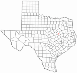
 Location of Groesbeck, Texas | |
 | |
| Country | United States |
| State | Texas |
| County | Limestone |
| Area | |
| • Total | 3.8 sq mi (9.8 km2) |
| • Land | 3.8 sq mi (9.7 km2) |
| • Water | 0.0 sq mi (0.0 km2) |
| Elevation | 479 ft (146 m) |
| Population (2000) | |
| • Total | 4,291 |
| • Density | 1,141.3/sq mi (440.6/km2) |
| Time zone | UTC-6 (Central (CST)) |
| • Summer (DST) | UTC-5 (CDT) |
| ZIP code | 76642 |
| Area code | 254 |
| FIPS code | 48-31280Template:GR |
| GNIS feature ID | 1358461Template:GR |
Groesbeck is a city in and the county seat of Limestone County, Texas, United States.Template:GR The population was 4,291 at the 2000 census. The community is named after a railroad employee.
History
Cynthia Ann Parker, mother of Quannah Parker was captured by the Comanche north of Groesbeck.
The arrival of the railroad in Groesbeck enabled it to become the county seat.
Residents of note
- Actor Joe Don Baker was born in Groesbeck in 1936.
- National Football League players Kenneth Sims, Frankie Smith, and Lenoy Jones played for Groesbeck High School.
- Groesbeck High School has an outstanding tennis program, having produced several state champions.
Geography
Groesbeck is located at 31°31′22″N 96°31′56″W / 31.52278°N 96.53222°WInvalid arguments have been passed to the {{#coordinates:}} function (31.522907, -96.532125).Template:GR
According to the United States Census Bureau, the city has a total area of 3.8 square miles (9.8 km²), of which, 3.8 square miles (9.7 km²) of it is land and 0.27% is water.
The community is located at the junction of State Highways 14 and 164.
Groesbeck is the closest town to historic Old Fort Parker. (See Fort Parker massacre) The town holds an annual Christmas Festival at the site of old Fort Parker every December. The original fort has been re-built on the original site to exact specifications.
Demographics
As of the censusTemplate:GR of 2000, there were 4,291 people, 1,297 households, and 878 families residing in the city. The population density was 1,141.3 people per square mile (440.6/km²). There were 1,457 housing units at an average density of 387.5/sq mi (149.6/km²). The racial makeup of the city was 58.56% White, 24.91% African American, 0.37% Native American, 0.05% Asian, 0.02% Pacific Islander, 13.96% from other races, and 2.12% from two or more races. Hispanic or Latino of any race were 17.53% of the population.
There were 1,297 households out of which 34.0% had children under the age of 18 living with them, 46.3% were married couples living together, 16.9% had a female householder with no husband present, and 32.3% were non-families. 30.2% of all households were made up of individuals and 17.8% had someone living alone who was 65 years of age or older. The average household size was 2.55 and the average family size was 3.16.
In the city the population was spread out with 22.9% under the age of 18, 14.1% from 18 to 24, 32.3% from 25 to 44, 16.1% from 45 to 64, and 14.5% who were 65 years of age or older. The median age was 32 years. For every 100 females there were 138.8 males. For every 100 females age 18 and over, there were 148.5 males.
The median income for a household in the city was $24,880, and the median income for a family was $32,263. Males had a median income of $24,704 versus $18,167 for females. The per capita income for the city was $12,005. About 18.6% of families and 21.4% of the population were below the poverty line, including 28.0% of those under age 18 and 23.8% of those age 65 or over.
Library
The city of Groesbeck has one public library, Maffett Memorial Library. The Maffett Memorial Public Library is located at 601 W. Yeagua St., also known as Hwy. 164.
Education
The city of Groesbeck is served by the Groesbeck Independent School District, which includes five different schools: Preschool, H.O.Whitehurst, Enge Washington, Groesbeck Middle School, and Groesbeck High School.
References

