
Mojave Desert: Difference between revisions
Darth Panda (talk | contribs) m Reverted edits by 69.204.157.102 to last version by Stan Shebs (HG) |
|||
| Line 87: | Line 87: | ||
* [[White woolly daisy]] |
* [[White woolly daisy]] |
||
* [[Wide-bannered lupine]] |
* [[Wide-bannered lupine]] |
||
* The wildass gal |
|||
* coolio coyote |
|||
* best eva kids |
|||
* not ass licking dogs |
|||
* not addicted to computer birds |
|||
* no other gay animals |
|||
* birds |
|||
* dogs |
|||
* bitches |
|||
* assholes |
|||
* jackasses |
|||
* retards |
|||
* weetards |
|||
* people that hate other people |
|||
* canibals |
|||
* non canibals |
|||
* hehehehe |
|||
* hahahaha |
|||
* hihihihi |
|||
* hohohoho |
|||
* hell hell hell |
|||
* let me finish this page please |
|||
* if u havent realized all of the above are fake |
|||
* haha stupid ass |
|||
* double retard |
|||
* sorry im running out of stuff to say |
|||
* o well |
|||
* the end |
|||
=== Animals === |
=== Animals === |
||
Revision as of 03:57, 10 February 2009
- For the indigenous American tribe, see Mohave.
The Mojave Desert (Template:PronEng or /məˈhɑːvi/), (Hayikwiir Mat'aar[1] in Mojave), locally referred to as the High Desert, occupies a significant portion of southeastern California and smaller parts of central California, southern Nevada, and northwestern Arizona, in the United States. Named after the Mohave tribe of Native Americans, it occupies well over 22,000 square miles (57,000 km2) in a typical Basin and Range topography.
The Mojave Desert's boundaries are generally defined by the presence of Yucca brevifolia (Joshua tree) considered an indicator species for this desert. The topographical boundaries include the Tehachapi together with the San Gabriel and San Bernardino mountain ranges. The mountain boundaries are quite distinct since they are outlined by the two largest faults in California: the San Andreas and the Garlock. The Great Basin shrub steppe lies to the north; the warmer Sonoran Desert (the Low Desert) lies to the south and east. The desert is believed to support between 1,750 and 2,000 species of plants.
Climate


The Mojave Desert receives less than 10 inches (250 mm) of rain a year and is generally between 3,000 and 6,000 feet (1,000 and 2,000 m) in elevation. The Mojave Desert also contains the Mojave National Preserve, as well as the lowest and hottest place in North America: Death Valley, where the temperature normally approaches 120°F (49°C) in late July and early August. Zion National Park, in Utah, lies at the junction of the Mojave, the Great Basin, and the Colorado Plateau. Despite its aridity, the Mojave (and particularly the Antelope Valley in its southwest) has long been a center of alfalfa production, fed by irrigation coming from groundwater and (in the 20th century) from the California Aqueduct.
The Mojave is a desert of temperature extremes and four distinct seasons. Winter months bring temperatures dipping to below 20 °F (-7 °C) on valley floors, and below 0 °F (-18 °C) at higher elevations. Storms moving from the Pacific Northwest can bring rain and snow across the region — more often, the rain shadow created by the Sierra Nevada as well as mountain ranges within the desert such as the Spring Mountains bring only clouds and wind. In longer periods between storm systems, winter temperatures in valleys can approach 80 °F (27 °C).
Spring weather continues to be influenced by Pacific storms, but rainfall is more widespread and occurs less frequently after April. By early June, it is rare for another Pacific storm to have a significant impact on the region's weather, and temperatures after mid-May are normally above 90 °F (32 °C) and frequently above 100 °F (38 °C).
Summer weather is dominated by heat — temperatures on valley floors can soar above 120 °F (49 °C) and above 130 °F (54 °C) at the lowest elevations — and the presence of the North American monsoon. Low humidity, high temperatures and low pressure draw in moisture from the Gulf of Mexico, creating thunderstorms across the desert southwest. While the Mojave does not get nearly the amount of rainfall that the Sonoran desert to the east receives, monsoonal moisture will create thunderstorms as far west as California's Central Valley from mid-June through early September.
Autumns are generally pleasant, with one to two Pacific storm systems creating regional rain events. October is one of the driest and sunniest months in the Mojave, and temperatures usually remain between 70 °F (21 °C) and 90 °F (32 °C) on the valley floors.
After temperature, wind is the most significant weather phenomenon in the Mojave. Across the region, windy days are common, and in areas near the transition between the Mojave and the California low valleys, including near Cajon Pass, Soledad Canyon and the Tehachapi areas. During the June Gloom, cooler air can be pushed out into the desert from Southern California; in Santa Ana wind events, hot air from the desert blows out into the Los Angeles basin and other coastal areas. Wind farms in these areas generate power from these winds.
The other major weather factor in the region is elevation. The highest peak within the Mojave is Charleston Peak at 11,918 feet (3,633 m), while Badwater in Death Valley is 282 feet (86 m) below sea level. Accordingly, temperatures and precipitation ranges wildly, in all seasons, across the region.
The Mojave Desert has not historically supported a fire regime because of low fuel loads and connectivity. However, in the last few decades, invasive annual plants (e.g., Bromus spp., Schismus spp., Brassica spp.) have facilitated fire, which has significantly altered many areas of the desert. At higher elevations, fire regimes are regular but infrequent.
Cities and regions

While the Mojave Desert itself is sparsely populated, it has increasingly become urbanized in recent years. Las Vegas, Nevada is the largest city in the Mojave, with a metropolitan population of around 1.9 million in 2006. Palmdale is the largest city in California in the desert, and over 850,000 people live in areas of the Mojave attached to the Greater Los Angeles metropolitan area, including Palmdale and Lancaster (referred to as the Antelope Valley); and Victorville and Hesperia (referred to as the Victor Valley) attached to the Inland Empire metropolitan area, the 14th largest in the nation. Smaller cities in the Mojave include St. George; Lake Havasu City; Kingman; Laughlin; Bullhead City; and Pahrump. All have experienced rapid population growth since 1990.
Towns with fewer than 30,000 people in the Mojave include Barstow, California; Rosamond, California; Needles, California; Ridgecrest, California; Mesquite, Nevada; Hurricane, Utah; Moapa Valley, Nevada; California City, California; Twentynine Palms, California; Joshua Tree, California; Pioneertown, California; and Mojave, California. The California portion of the desert also contains Edwards Air Force Base, the home of several past and current experimental aviation projects for the military.
The Mojave Desert contains a number of ghost towns, the most significant of these being the silver-mining town of Calico, California and the old railroad depot of Kelso. Some of the other ghost towns are of the more modern variety, created when U.S. Route 66 (and the lesser-known US Highway 91) were abandoned in favor of the Interstates. The Mojave Desert is crossed by major highways Interstate 15, Interstate 40, US Highway 395 and US Highway 95.
Other than the Colorado River on the eastern half of the Mojave, few long streams cross the desert. The Mojave River is an important source of water for the southern parts of the desert. The Amargosa River flows from the Great Basin Desert south to near Beatty, Nevada, then underground through Ash Meadows before returning to the surface near Shoshone, California and ending in Death Valley.
Tourism

The Mojave Desert is one of the most popular tourism spots in North America, primarily because of gambling destination Las Vegas. The desert is also known for its scenic beauty, with four national parks – Death Valley, Joshua Tree, Zion and Grand Canyon all within the desert or adjoining it. Lakes Mead, Mohave and Havasu provide watersport recreation, and vast off-road areas entice off-road enthusiasts. Hoover Dam is a popular tourist destination. Visitors get a chance to see the structure, the hydroelectric power plant, and hear the incredible history of the dam's construction during the Great Depression.
Besides the major national parks there are other areas of identified significance and tourist interest in the desert such as the Big Morongo Canyon Preserve, which spans the Mojave and Colorado Desert, and the Red Rock Canyon National Conservation Area, 17 miles (27 km) west of Las Vegas, both of which are managed by the Bureau of Land Management. The BLM also administers Rainbow Basin and Owl Canyon, two off-the-beaten-path scenic attractions north of Barstow. For the ATV/motorcycle crowd, the BLM runs several massive OHV areas in the Mojave, including Stoddard Valley, Johnson Valley, Basin and Dumont Dunes.
Among the more popular and unique tourist attractions in the Mojave is the self described world's tallest thermometer at 134 feet (40.8 m) high, which is located along Interstate 15 in Baker, California. The newly-renovated Kelso Depot and the massive Kelso Dunes in the nearby Mojave National Preserve are also popular recreation spots. Calico Ghost Town, in Yermo, is administered by San Bernardino County. The pseudo-authentic ghost town has several shops and attractions, and is said to have inspired Walter Knott to build Knott's Berry Farm.
The Calico Early Man Site, in the Calico Hills east of Yermo, is believed by some archaeologists, including the world-renowned Louis Leakey, to house the earliest evidence of human activity on the North American continent.
Native Mojave plants and animals
Plants
- Abies concolor
- Astragalus newberryi
- Barrel Cactus
- Banana yucca
- Beaver Tail Prickly Pear
- California Fan Palm
- Camissonia campestris Mojave suncup
- Cooper dyssodia
- Death Valley monkeyflower
- Desert candle
- Desert five-spot
- Desert larkspur
- Desert Lily
- Desert rock pea
- Desert star
- Erigeron concinnus
- Ipomopsis arizonica
- Joshua Tree[2]
- Jumping Cholla
- Larrea tridentata
- Linanthus demissus
- Lupinus arizonicus
- Mojave prickly poppy
- Mojave sage[3]
- Mojave yucca[3]
- Mormon Tea
- Pencil Cholla
- Phacelia calthifolia
- Phacelia crenulata
- Pinus monophylla
- Prairie clover
- Senna covesii
- Teddy-bear Cholla[3]
- Utah Juniper
- Western poison oak[4]
- White woolly daisy
- Wide-bannered lupine
- The wildass gal
- coolio coyote
- best eva kids
- not ass licking dogs
- not addicted to computer birds
- no other gay animals
- birds
- dogs
- bitches
- assholes
- jackasses
- retards
- weetards
- people that hate other people
- canibals
- non canibals
- hehehehe
- hahahaha
- hihihihi
- hohohoho
- hell hell hell
- let me finish this page please
- if u havent realized all of the above are fake
- haha stupid ass
- double retard
- sorry im running out of stuff to say
- o well
- the end
Animals

- Chuckwalla
- Common Side-blotched Lizard
- Cottontail Rabbit
- Cougar
- Coyote
- Desert Bighorn Sheep
- Desert Chipmunk
- Desert horned lizard
- Desert iguana
- Desert kit fox
- Desert night lizard
- Desert tortoise
- Fringe-toed lizard
- Gila Monster
- Glossy Snake
- Gopher Snake
- Great Basin Collared Lizard
- Hummingbird
- Jackrabbit
- Kangaroo Rat

- Long-nosed Leopard Lizard
- Mojave Green Rattlesnake
- Mohave tui chub - an endangered fish
- Mule Deer
- Pronghorn
- Red-spotted Toad
- Red-tailed Hawk
- Rosy boa
- Tarantula
- Western Diamondback Rattlesnake
- Zebra-tailed lizard
Gallery
-
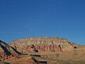
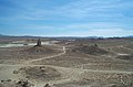 Pinnacles National Natural Landmark
 -
 Slot Canyon in Afton Canyon
 -
 Dust Devil, El Mirage Dry Lake
 -
 Water hole, Coyote Dry Lake
 -
 Rainbow Canyon, near the city of Barstow
 -
 Amboy Crater
 -
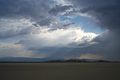 Summer Storm
 -
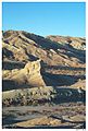
 Pioneer cabin remains near St. George, Utah.
 -
 Beaver Dam Mountains in southwestern Utah.
 -
 Virgin River Gorge, Arizona.
 -

-
 Barrel cactus in Virgin River Gorge, Arizona.
 -
 Joshua trees in Washington County, Utah in the southwest corner of the state.
 -
 Yucca plant.
 -
Virgin River in Mohave County, Arizona.
-
 Joshua Tree Forest near the Grand Canyon, Arizona
 -
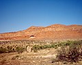
 Just south of Highway 95
 -
 The view from Zabriski Point of Furnace Creek in Death Valley
 -
 Just south of highway 95 in the Mojave Desert lies what remains of the Joshua Tree from the album of the same name by the band U2. The tree fell in the winter of 1999-2000


See also
- Amboy Crater
- Death Valley and Death Valley National Park
- Lake Dolores
- List of California regions
- Mojave phone booth
- Mojave Road
- Palen Mountains
- Solar power plants in the Mojave Desert
- Sonoran Desert
- Zzyzx Road A road that runs through the Mojave Desert
- Shrub-steppe
External links
References
- ^ Munro, P et al. A Mojave Dictionary Los Angeles: UCLA, 1992
- ^ Michael G. Barbour, William Dwight Billings (2000) North American Terrestrial Vegetation, Cambridge University Press, 708 pp ISBN 0521559863
- ^ a b c John Annerino (1999) Canyoneering: How to Explore the Canyons of the Great Southwest, Stackpole Books, 154 pp ISBN 0811727009
- ^ C.Michael Hogan (2008) "Western poison-oak: Toxicodendron diversilobum", GlobalTwitcher, ed. Nicklas Strömberg
Further reading
- Miller, D.M. and Amoroso, L. (2007). Preliminary surficial geology of the Dove Spring off-highway vehicle open area, Mojave Desert, California [U.S. Geological Survey Open-File Report 2006-1265]. Reston, VA: U.S. Department of the Interior, U.S. Geological Survey.
- Mojave Desert Wildflowers, Jon Mark Stewart, 1998, pg. iv
Colorado River system | |||||||||
|---|---|---|---|---|---|---|---|---|---|
| Jurisdictions |
|     | |||||||
| Canyons |
| ||||||||
| Natural features |
| ||||||||
| Tributaries | |||||||||
| Engineering |
| ||||||||
| Designated areas | |||||||||
| Related topics | |||||||||