{{Main|Ahom Dynasty|Ahom-Mughal conflicts|Battle of Saraighat}}
{{Main|Ahom Dynasty|Ahom-Mughal conflicts|Battle of Saraighat}}
The Ahom kingdom was established in 1228 when the first Ahom king [[Sukaphaa]] came from [[Mong Mao]] and entered the [[Brahmaputra]] valley, crossing the rugged [[Patkai]] mountain range.<ref>{{harv|Gogoi|2002|p=25}}</ref> In Sukaphaa's journey from his homeland and settlement in the Brahmaputra valley, he was supported and joined by other Tai chiefs and common followers<ref>{{harvcol|Buragohain|2013|p=84}}</ref> totaling about nine thousand persons. He crossed the Patkai and reached Namruk ([[Namrup]]) on 2 December 1228 and occupied a region on the south bank with the [[Dihing River|Burhidihing]] river in the north, the [[Dikhow River|Dikhau]] river in the south and the Patkai mountains in the east.<ref>{{Harvcol|Gogoi|1968|p=266}}</ref> He came into a region that was earlier the domain of the [[Kamarupa]] kingdom, but which had since lapsed into retarded conditions.<ref>"The po]itical heritage of ancient Kamarupa had not left Upper Assam totally untouched. After its eclipse, though the south-eastern part of Upper Assam had lapsed into retarded conditions, the fragmented political structures incorporating that tradition still loomed large in the form of petty chiefdoms (bhuyan-raj) in the vicinity. It was under such circumstances that the Ahoms started building a state system of their own in the easternmost extremity of the Brahmaputra Valley." {{harvcol|Guha|1983|p=10}}</ref> He befriended the local groups, the Barahi and the [[Moran people|Marans]], finally settled his capital at [[Charaideo]] and established the offices of the Dangarias— the [[Burhagohain]] and the [[Borgohain]]. In the 1280s, these two offices were given independent regions of control and the check and balance that these three main offices accorded each other was established. The Ahoms brought with them the technology of wet rice cultivation that they shared with other groups. The people that took to the Ahom way of life and polity were incorporated into their fold in a process of Ahomization.<ref>"(In Upper Assam), the Ahoms assimilated some of their Naga, Moran and Barahi neighbours and later, also large sections of the Chutiya and Kachari tribes. This Ahomisation process went on until the expanded Ahom society itself began to be Hinduised from the mid-16th century onward." {{Harvcol|Guha|1983|p=12}}</ref> As a result of this process the Barahi people, for instance, were completely subsumed, and some of the other groups like some Nagas and the Maran peoples became Ahoms, thus enhancing the Ahom numbers significantly. This process of Ahomization was particularly significant till the 16th century when under [[Suhungmung]], the kingdom made large territorial expansions at the cost of the [[Chutiya kingdom|Chutiya]] and the [[Kachari kingdom|Kachari]] kingdoms.
The Ahom kingdom was established in 1228 when the first Ahom king [[Sukaphaa]] came from [[Mong Mao]] and entered the [[Brahmaputra]] valley, crossing the rugged [[Patkai]] mountain range.<ref>{{harv|Gogoi|2002|p=25}}</ref> In Sukaphaa's journey from his homeland and settlement in the Brahmaputra valley, he was supported and joined by other Tai chiefs and common followers<ref>{{harvcol|Buragohain|2013|p=84}}</ref> totaling about nine thousand persons. He crossed the Patkai and reached Namruk ([[Namrup]]) on 2 December 1228 and occupied a region on the south bank with the [[Dihing River|Burhidihing]] river in the north, the [[Dikhow River|Dikhau]] river in the south and the Patkai mountains in the east.<ref>{{Harvcol|Gogoi|1968|p=266}}</ref> He came into a region that was earlier the domain of the [[Kamarupa]] kingdom, but which had since lapsed into retarded conditions,<ref>"The po]itical heritage of ancient Kamarupa had not left Upper Assam totally untouched. After its eclipse, though the south-eastern part of Upper Assam had lapsed into retarded conditions, the fragmented political structures incorporating that tradition still loomed large in the form of petty chiefdoms (bhuyan-raj) in the vicinity. It was under such circumstances that the Ahoms started building a state system of their own in the easternmost extremity of the Brahmaputra Valley." {{harvcol|Guha|1983|p=10}}</ref> not to conquer and raid, but to permanently settle in fallow land and practice agriculture.<ref>"Sukapha came not as a raiding conqueror but as the head of an agricultural folk in search of land. It appears he did not encroach upon the lands of the local peasants, rather he opened up new areas of settlement, procuring with shrewd diplomacy what he direly needed for the purpose---the service of the local inhabitants." {{harvcol|Baruah|1983|p=222}}</ref> He befriended the local groups, the Barahi and the [[Moran people|Marans]], finally settled his capital at [[Charaideo]] and established the offices of the Dangarias— the [[Burhagohain]] and the [[Borgohain]]. In the 1280s, these two offices were given independent regions of control and the check and balance that these three main offices accorded each other was established. The Ahoms brought with them the technology of wet rice cultivation that they shared with other groups. The people that took to the Ahom way of life and polity were incorporated into their fold in a process of Ahomization.<ref>"(In Upper Assam), the Ahoms assimilated some of their Naga, Moran and Barahi neighbours and later, also large sections of the Chutiya and Kachari tribes. This Ahomisation process went on until the expanded Ahom society itself began to be Hinduised from the mid-16th century onward." {{Harvcol|Guha|1983|p=12}}</ref> As a result of this process the Barahi people, for instance, were completely subsumed, and some of the other groups like some Nagas and the Maran peoples became Ahoms, thus enhancing the Ahom numbers significantly. This process of Ahomization was particularly significant till the 16th century when under [[Suhungmung]], the kingdom made large territorial expansions at the cost of the [[Chutiya kingdom|Chutiya]] and the [[Kachari kingdom|Kachari]] kingdoms.
The expansion was so large and so rapid that the Ahomization process could not keep pace and the Ahoms became a minority in their kingdom. This resulted in a change in the character of the kingdom and it became multi-ethnic and inclusive. Hindu influences were first felt under [[Sudangphaa|Bamuni Konwar]] at the end of the 14th century, became significant only by the mid-17th century.<ref>"This influence [Hindu influence] began to be slowly absorbed and became substantial only by the mid-17th century."{{harvcol|Guha|1983|p=14}}</ref> The [[Assamese language]] entered the Ahom court and co-existed with the [[Tai language]] for some time in the 17th century before finally replacing it.<ref>"In (the 17th) century of Ahom-Mughal conflicts, (the Tai) language first coexisted with and then was progressively replaced by Assamese (Asamiya) at and outside the Court." {{Harv|Guha|1983|p=9}}</ref> The rapid expansion of the state was accompanied by the installation of a new high office, the [[Borpatrogohain]], at par with the other two high offices and not without opposition from them. Two special offices, the Sadiakhowa Gohain, and the Marangikowa Gohain were created to oversee the regions won over from the [[Chutia kingdom|Chutia]] and the [[Dimasa kingdom|Kachari]] kingdoms respectively. The subjects of the kingdom were organized under the [[Paik system]], initially based on the {{transliteration|as|phoid}} or kinship relations, which formed the militia. The kingdom came under attack from [[Turkic people|Turkic]] and [[Afghans|Afghan]] rulers of [[Bengal]], but it withstood them. On one occasion, the Ahoms under Ton Kham [[Borgohain]]<ref>Tom Kham was the son of Phrasengmong Borgohain and Mula Gabhoru, both warriors who were killed in battles against Turbak.</ref> pursued the invaders and reached the [[Karatoya River|Karatoya]] river<ref>"The Ahom expeditionary force, led by General Ton Kham and aided by General Kan Seng and General Kham Peng, pursued the retreating enemies across Muslim domains of Kamarupa and Kamata receiving little resistance in them and reached Karatoya, the eastern boundary of Gaur proper, where the victors washed their swords."{{harv|Gogoi|1968|p=302}}</ref> and the Ahoms began to see themselves as the rightful heir of the erstwhile [[Kamarupa kingdom]].<ref>:The Ahom statesmen and chroniclers wishfully looked forward to the Karatoya as their natural western frontier. They also looked upon themselves as the heirs of the glory that was ancient Kamarupa by right of conquest, and they long cherished infructuous their unfulfilled hopes of expanding up to that frontier." {{Harvcol|Guha|1983|p=24}}, and notes.</ref> The kingdom was also involved in neutralising the Burmese aggression on other Shan states especially during the reign of Ahom king [[Suklenmung]] (1539–52) who intervened in a border dispute between the [[First Toungoo Empire|Burmese Toungoo Empire]] and [[Mongkawng|Mougkawg]] on the request of Mougkawg ruler Chao Siu-Kwei.<ref>"Towards the middle of the sixteenth century, Ahom king Siu-Klen Mong (1539-52) intervened in favour of Mong Kwang against a border dispute with the Burmese. In recognition of this service, the Mong Kwang ruler, who was probably Chao Siu-Kwei"{{harvcol|Phukan|1991|p=891}}</ref> It is claimed that the Ahom capital [[Garhgaon]] was built at the advice of Chao Siu-Kwei's daughter Nang Sao Seng who was married to Suklenmung.<ref>"It is said that the Ahom capital Gargoan was built at the suggestion of this Mong Kwang Queen [Nang Sao Seng]"{{harvcol|Phukan|1991|p=891}}</ref>
The expansion was so large and so rapid that the Ahomization process could not keep pace and the Ahoms became a minority in their kingdom. This resulted in a change in the character of the kingdom and it became multi-ethnic and inclusive. Hindu influences were first felt under [[Sudangphaa|Bamuni Konwar]] at the end of the 14th century, became significant only by the mid-17th century.<ref>"This influence [Hindu influence] began to be slowly absorbed and became substantial only by the mid-17th century."{{harvcol|Guha|1983|p=14}}</ref> The [[Assamese language]] entered the Ahom court and co-existed with the [[Tai language]] for some time in the 17th century before finally replacing it.<ref>"In (the 17th) century of Ahom-Mughal conflicts, (the Tai) language first coexisted with and then was progressively replaced by Assamese (Asamiya) at and outside the Court." {{Harv|Guha|1983|p=9}}</ref> The rapid expansion of the state was accompanied by the installation of a new high office, the [[Borpatrogohain]], at par with the other two high offices and not without opposition from them. Two special offices, the Sadiakhowa Gohain, and the Marangikowa Gohain were created to oversee the regions won over from the [[Chutia kingdom|Chutia]] and the [[Dimasa kingdom|Kachari]] kingdoms respectively. The subjects of the kingdom were organized under the [[Paik system]], initially based on the {{transliteration|as|phoid}} or kinship relations, which formed the militia. The kingdom came under attack from [[Turkic people|Turkic]] and [[Afghans|Afghan]] rulers of [[Bengal]], but it withstood them. On one occasion, the Ahoms under Ton Kham [[Borgohain]]<ref>Tom Kham was the son of Phrasengmong Borgohain and Mula Gabhoru, both warriors who were killed in battles against Turbak.</ref> pursued the invaders and reached the [[Karatoya River|Karatoya]] river<ref>"The Ahom expeditionary force, led by General Ton Kham and aided by General Kan Seng and General Kham Peng, pursued the retreating enemies across Muslim domains of Kamarupa and Kamata receiving little resistance in them and reached Karatoya, the eastern boundary of Gaur proper, where the victors washed their swords."{{harv|Gogoi|1968|p=302}}</ref> and the Ahoms began to see themselves as the rightful heir of the erstwhile [[Kamarupa kingdom]].<ref>:The Ahom statesmen and chroniclers wishfully looked forward to the Karatoya as their natural western frontier. They also looked upon themselves as the heirs of the glory that was ancient Kamarupa by right of conquest, and they long cherished infructuous their unfulfilled hopes of expanding up to that frontier." {{Harvcol|Guha|1983|p=24}}, and notes.</ref> The kingdom was also involved in neutralising the Burmese aggression on other Shan states especially during the reign of Ahom king [[Suklenmung]] (1539–52) who intervened in a border dispute between the [[First Toungoo Empire|Burmese Toungoo Empire]] and [[Mongkawng|Mougkawg]] on the request of Mougkawg ruler Chao Siu-Kwei.<ref>"Towards the middle of the sixteenth century, Ahom king Siu-Klen Mong (1539-52) intervened in favour of Mong Kwang against a border dispute with the Burmese. In recognition of this service, the Mong Kwang ruler, who was probably Chao Siu-Kwei"{{harvcol|Phukan|1991|p=891}}</ref> It is claimed that the Ahom capital [[Garhgaon]] was built at the advice of Chao Siu-Kwei's daughter Nang Sao Seng who was married to Suklenmung.<ref>"It is said that the Ahom capital Gargoan was built at the suggestion of this Mong Kwang Queen [Nang Sao Seng]"{{harvcol|Phukan|1991|p=891}}</ref>
Though it came to be called the Ahom kingdom in the colonial and subsequent times, it was largely multi-ethnic, with the ethnic Tai-Ahom people constituting less than 10% of the population toward the end.[7]
People from different ethnic groups became a part of the Ahom population due to the process known as Ahomisation. The identity of the Ahom people in this kingdom was fluid, with the king controlling who belonged to it and who did not.[8] The Ahoms initially called their kingdom Mong Dun Shun Kham till 1401 (Assamese: xunor-xophura; English: casket of gold), but adopted Assam in later times.[9] The British-controlled province after 1838 and later the Indian state of Assam came to be known by this name. The kingdom maintained close political ties with other Tai-states especially with Mong Kwang (Nara) till the end of its rule in the 19th century.[10]
The Ahom kingdom was established in 1228 when the first Ahom king Sukaphaa came from Mong Mao and entered the Brahmaputra valley, crossing the rugged Patkai mountain range.[11] In Sukaphaa's journey from his homeland and settlement in the Brahmaputra valley, he was supported and joined by other Tai chiefs and common followers[12] totaling about nine thousand persons. He crossed the Patkai and reached Namruk (Namrup) on 2 December 1228 and occupied a region on the south bank with the Burhidihing river in the north, the Dikhau river in the south and the Patkai mountains in the east.[13] He came into a region that was earlier the domain of the Kamarupa kingdom, but which had since lapsed into retarded conditions,[14] not to conquer and raid, but to permanently settle in fallow land and practice agriculture.[15] He befriended the local groups, the Barahi and the Marans, finally settled his capital at Charaideo and established the offices of the Dangarias— the Burhagohain and the Borgohain. In the 1280s, these two offices were given independent regions of control and the check and balance that these three main offices accorded each other was established. The Ahoms brought with them the technology of wet rice cultivation that they shared with other groups. The people that took to the Ahom way of life and polity were incorporated into their fold in a process of Ahomization.[16] As a result of this process the Barahi people, for instance, were completely subsumed, and some of the other groups like some Nagas and the Maran peoples became Ahoms, thus enhancing the Ahom numbers significantly. This process of Ahomization was particularly significant till the 16th century when under Suhungmung, the kingdom made large territorial expansions at the cost of the Chutiya and the Kachari kingdoms.
The expansion was so large and so rapid that the Ahomization process could not keep pace and the Ahoms became a minority in their kingdom. This resulted in a change in the character of the kingdom and it became multi-ethnic and inclusive. Hindu influences were first felt under Bamuni Konwar at the end of the 14th century, became significant only by the mid-17th century.[17] The Assamese language entered the Ahom court and co-existed with the Tai language for some time in the 17th century before finally replacing it.[18] The rapid expansion of the state was accompanied by the installation of a new high office, the Borpatrogohain, at par with the other two high offices and not without opposition from them. Two special offices, the Sadiakhowa Gohain, and the Marangikowa Gohain were created to oversee the regions won over from the Chutia and the Kachari kingdoms respectively. The subjects of the kingdom were organized under the Paik system, initially based on the phoid or kinship relations, which formed the militia. The kingdom came under attack from Turkic and Afghan rulers of Bengal, but it withstood them. On one occasion, the Ahoms under Ton Kham Borgohain[19] pursued the invaders and reached the Karatoya river[20] and the Ahoms began to see themselves as the rightful heir of the erstwhile Kamarupa kingdom.[21] The kingdom was also involved in neutralising the Burmese aggression on other Shan states especially during the reign of Ahom king Suklenmung (1539–52) who intervened in a border dispute between the Burmese Toungoo Empire and Mougkawg on the request of Mougkawg ruler Chao Siu-Kwei.[22] It is claimed that the Ahom capital Garhgaon was built at the advice of Chao Siu-Kwei's daughter Nang Sao Seng who was married to Suklenmung.[23]
The Ahom kingdom took many features of its mature form under Pratap Singha (1603–1641). The Paik system was reorganized under the professional khel system, replacing the kinship-based phoid system. Under the same king, the offices of the Borphukan, and the Borbarua were established along with other smaller offices. No more major restructuring of the state structure was attempted until the end of the kingdom. The kingdom came under repeated Mughal attacks in the 17th century, and on one occasion in 1662, the Mughals under Mir Jumla occupied the capital, Garhgaon. The Mughals were unable to keep it, and in at the end of the Battle of Saraighat, the Ahoms not only fended off a major Mughal invasion but extended their boundaries west, up to the Manas river. Following a period of confusion, the kingdom got itself the last set of kings, the Tungkhungia kings, established by Gadadhar Singha.
The rule of Tungkhungia Ahom kings was marked by achievements in the Arts and engineering constructions and also festering internal conflicts that tore the kingdom asunder. Rudra Singha (1696–1714) during his reign the kingdom reached its zenith, introduced Islamic prayers in the court that his successors continued.[24] The later phase of the rule was also marked by increasing social conflicts, leading to the Moamoria rebellion. The rebels were able to capture and maintain power at the capital Rangpur for some years but were finally removed with the help of the British under Captain Welsh. The following repression led to a large depopulation due to emigration as well as execution, but the conflicts were never resolved. A much-weakened kingdom fell to repeated Burmese attacks and finally after the Treaty of Yandabo in 1826, the control of the kingdom passed into British hands.
Ahom economic system
The Ahom kingdom was based on the Paik system, a type of corvee labor that is neither feudal nor Asiatic. The first coins were introduced by Suklenmung in the 16th century, though the system of personal service under the Paik system persisted. In the 17th century when the Ahom kingdom expanded to include erstwhile Koch and Mughal areas, it came into contact with their revenue systems and adapted accordingly.
Trade
Trade was carried on usually through barter and use of circulation of money was limited. According to Shihabududdin Tailash, currency in the Ahom kingdom consisted of cawries, rupees and gold coins. With the increase of external trade since the reign of Rudra Singha, there was a corresponding increase in the circuation of money. Inscriptions dating from the reign of Siva Singha, gives the price of number of commodities like rice, ghee, oil, pulses, goat, pegion in connection with worship in different temples of the kingdom.[25] This concludes that the barter economey was in the process of being replaced by the money economy, which was the outcome of Assam's developing economic ties both with feudal India and the neigbouring countries of the north east.
Population and extent of the Kingdom
The population of the kingdom before the Moamariya Rebellion and the Burmese invasions was estimated to be 25 lakhs, and the eligible adult male population was around 6 lakhs. During Rajeswar Singha reign the paiks available for actual mobilization was only 80,000.
[26]
In the 17th century, the fighting strength was around 240,000 adult males.[27] In extent the kingdom's length was about 500 miles (800 km) and with an average breadth of (60 miles) 96 km. It roughly corresponded to six districts of the Brahmaputra valley- Undivided Lakhimpur , Undivided Dibrugarh district, Undivided Sivasagar, Undivided Nagaon, Undivided Darrang and Undivided Kamrup . The uttarkul or northern bank was more populated and fertile but the Ahom kings set up their capital at dakhinkul on the south bank because it had more inaccessible strongholds and defensible central places.[28]
The Ahom kingdom was ruled by a king, called Swargadeo (Ahom language: Chao-Pha), who had to be a descendant of the first king Sukaphaa. Succession was generally by primogeniture but occasionally the great Gohains (Dangarias) could elect another descendant of Sukaphaa from a different line or even depose an enthroned one.
Keshav Narayan dol/temple, outer wall scluptures built by Swargadeo Rudra Singha
Dangarias: Sukaphaa had two great Gohains to aid him in administration: Burhagohain and the Borgohain. In the 1280s, they were given independent territories, they were veritable sovereigns in their given territories called bilat or rajya. The Burhagohain's territory was between Sadiya and Gerelua river in the north bank of the Brahmaputra river and the Borgohain's territory was to the west up to the Burai river.[29] They were given total command over the paiks that they controlled. These positions were generally filled from specific families. Princes who were eligible for the position of Swargadeo were not considered for these positions and vice versa. In the 1527, Suhungmung added a third Gohain, Borpatrogohain.[30] The Borpatrogohain's territory was located between the territories of the other two Gohains.
Royal officers: Pratap Singha added two offices, Borbarua and Borphukan, that were directly under the king. The Borbarua, who acted as the military as well as the judicial head, was in command of the region east of Kaliabor not under the command of the Dangarias. He could use only a section of the paiks at his command for his personal use (as opposed to the Dangariyas), the rest rendering service to the Ahom state. The Borphukan was in military and civil command over the region west of Kaliabor, and acted as the Swargadeo's viceroy in the west. Borbaruas were mostly from different Moran, Kachari, Chiring and Khamti communities, while Borphukans were from the Chutia community.[31] The Borbarua and Borphukan offices were not hereditary and thus could be chosen from any families.
Patra Mantris: The five positions constituted the Patra Mantris (Council of Ministers). From the time of Supimphaa (1492–1497), one of the Patra Mantris was made the Rajmantri (Prime Minister, also Borpatro; Ahom language: Shenglung) who enjoyed additional powers and the service of a thousand additional paiks from the Jakaichuk village.
Other officials
The Borbarua and the Borphukan had military and judicial responsibilities, and they were aided by two separate councils (sora) of Phukans. The Borphukan's sora sat at Guwahati and the Borbarua's sora at the capital. Six of them formed the council of the Borbarua with each having his separate duties. The Naubaicha Phukan, who had an allotment of thousand men managed the royal boats, the Bhitarual Phukan, the Na Phukan, the Dihingia Phukan, the Deka Phukan, and the Neog Phukan formed the council of Phukan. The Borphukan also had a similar council of six subordinate Phukans whom he was bound to consult in all matters of importance. This council included Pani Phukan, who commanded six thousand paiks, Deka Phukan who commanded four thousand paiks, the Dihingia Phukan, Nek Phukan and two Chutiya Phukans.
The superintending officers were called Baruas. The Baruas of whom there were twenty or more included Bhandari Barua or treasurer; the Duliya Barua, who was in charge of the royal palanquins; the Chaudang Barua who superintended executions; Khanikar Barua was the chief artificer; Sonadar Barua was the mint master and chief jeweler; the Bez Barua was the physician to the Royal family, Hati Barua, Ghora Barua, etc.
Other official included twelve Rajkhowas, and a number of Katakis, Kakatis, and Dolais. The Rajkhowas were governors of given territories and commanders of three thousand paiks. They were the arbitrator who settled local disputes and supervised public works. The Katakis were envoys who dealt with foreign countries and hill tribes. The Kakatis were writers of official documents. The Dolais expounded astrology and determined auspicious time and dates for any important event and undertaking.
Members of the royal families ruled certain areas, and they were called Raja.
Charing Raja, the heir apparent to the Swargadeo, administered the tracts around Joypur on the right bank of the Burhidihing river.
Tipam Raja is the second in line.
Namrup Raja is the third in line
Members of the royal families who occupy lower positions are given regions called mels, and were called meldangia or melkhowaraja. Meldangia Gohains were princes of an even lesser grade, of which there were two: Majumelia Gohain and Sarumelia Gohain.[32]
Royal ladies were given individual mels, and by the time of Rajeshwar Singha, there were twelve of them. The most important of these was the Raidangia mel given to the chief queen.[33]
Forward governors, who were military commanders, ruled and administered forward territories. The officers were usually filled from the families that were eligible for the three great Gohains.
File:Gun boy.pngA man reloading the matchlock. Stone carving from the lower portion of the Namdang bridge.Sadiya Khowa Gohain based in Sadiya, administered the Sadiya region that was acquired after the conquest of the Chutia kingdom in 1524.
Marangi khowa Gohain administered the region that was contiguous to the Naga groups west of the Dhansiri; acquired from the Kachari kingdom in 1526.
Solal Gohain administered a great part of Nagaon and a portion of Chariduar after the headquarters of the Borphukan was transferred to Gauhati.
File:Royal hunting.pngRoyal hunting party, probably hunting creature familiar to a lion with guns.Kajalimukhiya Gohain served under the Borphukan, administered Kajalimukh and maintained relations with Jaintia and Dimarua.[34]
Khamjangia Gohain administered the region of Khamjang (part of Naga hills).
Banrukia Gohain administered the region of Banruk (part of Sibsagar district).
The dependent kings or vassals were also called Raja. Except for the Raja of Rani, all paid an annual tribute. These Rajas were required to meet the needs for resources and paiks when the need arose, as during the time of war.
Beltola ruled the tracts southwest of Guwahati and were the descendants of Gaj Narayan, a grandson of Chilarai of the Koch dynasty
Luki
Barduar
Dimarua
Tapakuchi
Paik officials
The Ahom kingdom was dependent on the Paik system, a form of corvee labor, reorganized in 1608 by Momai Tamuli Barbarua.[35] Every common subject was a paik, and four paiks formed a got. At any time of the year, one of the paiks in the got rendered direct service to the king, as the others in his got tended to his fields. The Paik system was administered by the Paik officials: A Bora was in charge of 20 paiks, a Saikia of 100 and a Hazarika of 1000. A Rajkhowa commanded three thousand and a Phukan commanded six thousand paiks.[35]
Land survey
Supatphaa became acquainted with the land measurement system of Mughals during the time he was hiding in Kamrup before he succeeded to the throne. As soon as the wars with Mughals were over he issued orders for the introduction of a similar system throughout his dominions. Surveyors were imported from Koch Behar and Bengal for the work. It was commenced in Sibsagar and was pushed on vigorously, but it was not completed until after his death. Nowgaon was next surveyed, and the settlement which followed was supervised by Rudra Singha himself. According to historians, the method of survey included measuring the four sides of each field with a nal, or bamboo pole of 12 feet (3.7 m) length and calculating the area, the unit was the "lucha" or 144 square feet (13.4 m2) and 14,400 sq ft (1,340 m2). is one "Bigha". Four 'bigha' makes one 'Pura'. A similar land measurement system is still being followed in modern Assam.
Military
The Ahom military forces included infantry, cavalry, Elephantry, Artillery, Spies and Navy. Land was given to Martial Paiks or peasants in exchange for service. They were organised under various head. Bora was the leader of twenty paiks, Saikia was the leader of a hundred or more, and Hazarika was the leader of a thousand, a Barua was leader of 2000 soldiers, a Rajkowa a leader of 3000 soldiers and a Phukan of 6000 soldiers. The army's commander-in-chief was known as Borphukan. Swords, spears, bows, and arrows, guns, matchlocks, cannons were the primary weapons of the war. The soldiers had been trained to stand firm in battle. The cavalry commander was Ghora Barua, and the elephant commander was Hati Barua.[36]
The people of mediaeval Assam were aware of the use of incendiary weapons. However, firearms were first introduced in the early 16th century. The Ahom troops quickly became experts in the manufacture of various types of guns, small and large, matchlocks, artillery, and large cannon. Kharghariya Phukan was the officer in charge of the manufacture of gunpowder.[36]
The navy was the most important and powerful division of the Ahom forces. The main warships were known as bacharis. This shape was similar to Bengali kosahs, and each could carry 70 to 80 men. They were tough and powerful, and by the end of the period, many of them were armed with guns. The Fathiya-i-ibriya mentions 32,000 ships belonging to the king of Assam at the time of Mir Jumla's invasion. These were primarily made of chambal wood and were thus light and fast and so difficult to sink. The navy was led by the Naobaicha Phukan and Naosaniya Phukan.[36]
Forts were built in strategic locations to provide armed resistance. The Ahom soldiers were skilled at attacking the enemy at night. On the battlefield, a small group of Ahom soldiers could often outnumber thousands of enemy soldiers. Aside from their numerical strength, the Ahom paiks' physical strength, courage, and endurance were the most important factors in the Ahom military's invincibility.[36]
Judicial Administration
In civil matters, Hindu laws were generally followed, while the criminal law was characterized by sternness and comparative harshness, where the general principle was that of an eye for an eye and a tooth for a tooth, and the culprit was punished with precisely the same injury as that inflicted by him on the complainant. The Barbarua and the Barphukan were the chief judicial authorities in their respective provinces, and trials were conducted before them.[37]
Subinphaa (1281–1293), the third Ahom king, delineated the Satgharia Ahom ("Ahom of the seven houses") aristocracy: the Chaophaa, the Burhagohain and the Borgohain families, and four priestly lineages—the Deodhai, the Mohan, the Bailung and the Chiring Phukan . These lines maintained exogamous marital relationships. The number of lineages increased in later times as either other lineages were incorporated, or existing lineages divided. The king could belong to only the first family whereas the Burhagohain and the Borgohain only to the second and the third families. Most of the Borphukans belonged to the Chutia ethnic group, whereas the Borbaruas belonged to the Morans, Dimasas, Chiring and Khamti groups.[31] Later on Naga, Mising and Nara (Mongkawng) oracles became a part of the Bailung group.[38] The extended nobility consisted of the landed aristocracy and the spiritual class that did not pay any form of tax.
The apaikan chamua was the gentry that was freed from the khels and paid only money-tax. The paikan chamua consisted of artisans, the literati and skilled people that did non-manual work and rendered service as a tax. The kanri paik rendered manual labor. The lowest were the licchous, bandi-beti and other serfs and bondsmen. There was some degree of movement between the classes. Momai Tamuli Borbarua rose from a bondsman through the ranks to become the first Borbarua under Prataap Singha.
The culture of dance and music was widespread and the most popular manifestation of it was Bihu. Different styles of dances were performed Queen Phuleshwari was originally attached to Siva temple at Dergaon. Many types of musical instruments were used. Mughal music performances like Nageras under the Royal patronage were introduced. Rudra Singha had right regards for Mughal music and sent Assamese musicians to Delhi to learn the playing of the instruments like Pakhuaj. The king also appointed certain officers like Gyan barua, for the promotion of music and art.[39]The Assamese monarchs Rudra Singha and his son Siva Singha were both writers of songs. Rajeswar Singha was the author of a drama entitled Kichak Bandh. To celebrate the visit of the Rajas of Manipur and Cachar, a Bhaona was performed at the Ahom capital Rangpur, Assam and the master of the performance was the Deka-Barbarua, son of Kirti Chandra Barbarua.[40]
File:Kings men.pngAhom king soldiers, equipped with a weapon similar to a mace
The Ahom kings constructed a large number of temples dedicated to Shiva, Durga and Vishnu. On the whole, a distinct school of Assamese architecture never grew up and the traces of different Indian schools noted in them were the results of foreign hands employed by the kings for the works at different times. The Shiva dol at Sivasagar was constructed by Siva Singha. This temple has a mandapa, a Garbhagripha and a gate. The Devi temple at Gaurisagar does not contain the familiar amalaka, instead instead a tier of gold-plated kalash. The Umananda dol on the peacock island is an adjunct to the Kamakhya temple. It was built by Garhgayan Sandikai Phukan at the instance of Gadadhar Singha in 1694. The style of other temples of Ahom Kings are more or les similar to that of Shiva temple at Sivasagar. Some of the most important temples constructed under the patronage of the Ahom government are Sukleswar, Rudreswar and Navagraha temples at Guahati and the Siva temples at Dergoan and Biswanath, In Sivasagar , Vishnu shrines were also erected on the same site with Siva and Devi temples. Remains of the Ahom palaces constructed with brick are still extant. The metropolis at Rangpur contains the famous Talatal Ghar, Rang Ghar and in Garhgoan, Kareng Ghar.The ridge of the roof is buit in bricks and shaped like an amusement boat.[41] Of the numerous stone bridge constructed during the Ahom rule, only those over Namdang, Darika and Dijai are intact. The Namdang Stone Bridge built by Rudra Singha is 1703 in the biggest. An officer called Changrung Phukan was in charge of engineering and public works departments. He was to supervise every work and keep records of all details regarding it.[42]
Painting
Though there was a clear break in the ancient tradition of art and sculpture with its religious bias, in another artistic craft, that of manuscript painting, the Ahom period made memorable strides. The 18th century was a great period for miniature book illustrations on Sanchi pat. As S.K Chatterje observes: There are beautiful landscapes, mostly in green and undulating plains with flower trees, and hills and rivers. It is a wonder how the beauty of nature as spread out over the face of the earth could captivate these artists of Assam in a way it never did artists in other parts of India. Among other illustrated manuscript mention may be made of Sankhachuda-Vadha, Gita-Govinda, and Dhamra Purana. Of the secular branch of painting, the best and by far the unique is the Hastividyarnava. The two artists who worked on it were Dilar, a Muslim and Dasay, a Hindu. The pictures are in water-colour and a large of them are gold plated, still preserved in their original lusture. The painting representing various types of elephants and scenes from the Ahom royal court.[43]
Gallery
Rudra Singha
Siva Singha
Swargodeo offering prayer
The king on the elephant with the fourfold division of the army
Siva Singha instructing Dilbar and Dosai.
See also
Wikimedia Commons has media related to Ahom Kingdom.
^ ab"After 1770 started its period of decline-civil wars and depopulation followed by foreign occupations culminating in the final eclipse of 1826 by its take-over by the British." (Guha 1983:9)
^"The Chutiya power began to decline with the beginning of the 16th century. Taking advantage of an anarchical condition in the Chutia kingdom under the rule of inefficient Dhirnarayan (c1504-1523), the Ahom King Suhungmung or Dihingia Raja (1497-1539) annexed the kingdom in 1523"(Dutta 1985:29)
^"The Ahoms were never numerically dominant in the state they built and, at the time of 1872 and 1881 Censuses, they formed hardly one-tenth of the populations relevant to the erstwhile Ahom territory (i.e, by and large, the Brahmaputra Valley without the Goalpara district.)" (Guha 1983:9)
^(Saikia 2004:140–141) By emphasizing the fluidity of this identity, the swargadeos controlled and directed the continuous movement within and beyond this group which, in turn, never allowed for developing any sense of loyalty to or cohesiveness of the group. Ahom was not an identity to die for in precolonial Assam; in fact, nobody could ever claim ownership of this label because it was left to the discretion of the swargodeo to award or demote a person to and from this status
^"Tributes seem to have flowed to their original state in Upper Burma from Mungdungshunkham and probably the covert colonialism ended in 1401 when the boundary between Mungdungshunkham and the Nara kingdom was finally fixed at the Patkai hills. There is reason to believe that the name Mungdunshunkham is closely associated with this covert colonialism of the time and it automatically disappeared when Mungdunshunkham became Asom after their new name Ahom.(Buragohain 1988:54–55)
^"In his letter, the Mong Kwang ruler requested Kamaleswarsingha (1795-1811) for help against the king of Burma who had invaded his territory. Referring to the close tie existing between the two kingdoms, the Mong Kwang ruler hoped for positive response from the Ahom king to repel the Burmese invaders"(Phukan 1991:892)
^"The po]itical heritage of ancient Kamarupa had not left Upper Assam totally untouched. After its eclipse, though the south-eastern part of Upper Assam had lapsed into retarded conditions, the fragmented political structures incorporating that tradition still loomed large in the form of petty chiefdoms (bhuyan-raj) in the vicinity. It was under such circumstances that the Ahoms started building a state system of their own in the easternmost extremity of the Brahmaputra Valley." (Guha 1983:10)
^"Sukapha came not as a raiding conqueror but as the head of an agricultural folk in search of land. It appears he did not encroach upon the lands of the local peasants, rather he opened up new areas of settlement, procuring with shrewd diplomacy what he direly needed for the purpose---the service of the local inhabitants." (Baruah 1983:222) harvcol error: no target: CITEREFBaruah1983 (help)
^"(In Upper Assam), the Ahoms assimilated some of their Naga, Moran and Barahi neighbours and later, also large sections of the Chutiya and Kachari tribes. This Ahomisation process went on until the expanded Ahom society itself began to be Hinduised from the mid-16th century onward." (Guha 1983:12)
^"This influence [Hindu influence] began to be slowly absorbed and became substantial only by the mid-17th century."(Guha 1983:14)
^"In (the 17th) century of Ahom-Mughal conflicts, (the Tai) language first coexisted with and then was progressively replaced by Assamese (Asamiya) at and outside the Court." (Guha 1983, p. 9)
^Tom Kham was the son of Phrasengmong Borgohain and Mula Gabhoru, both warriors who were killed in battles against Turbak.
^"The Ahom expeditionary force, led by General Ton Kham and aided by General Kan Seng and General Kham Peng, pursued the retreating enemies across Muslim domains of Kamarupa and Kamata receiving little resistance in them and reached Karatoya, the eastern boundary of Gaur proper, where the victors washed their swords."(Gogoi 1968, p. 302)
^:The Ahom statesmen and chroniclers wishfully looked forward to the Karatoya as their natural western frontier. They also looked upon themselves as the heirs of the glory that was ancient Kamarupa by right of conquest, and they long cherished infructuous their unfulfilled hopes of expanding up to that frontier." (Guha 1983:24), and notes.
^"Towards the middle of the sixteenth century, Ahom king Siu-Klen Mong (1539-52) intervened in favour of Mong Kwang against a border dispute with the Burmese. In recognition of this service, the Mong Kwang ruler, who was probably Chao Siu-Kwei"(Phukan 1991:891)
^"It is said that the Ahom capital Gargoan was built at the suggestion of this Mong Kwang Queen [Nang Sao Seng]"(Phukan 1991:891)
^"(Rudra Singha) accepted a Muslim named Shah Newaj as a priest in the court, who used to pray for the prosperity of the kingdom in Islamic form. This custom introduced by him was followed by his successors." (Baruah 1978, p. 577)
^Comprehensive history of Assam, SL Baruah. p. 442.
^The Ahom Political System: an Enquiry into the State Formation Process in Medieval Assam: 1228-1714. p. 181.
^ ab"Most of the Borbaruas were selected from Moran, Kachari, Chiring and Khamti families. The office of the Governor general, lower Assam, was appointed from a Chutiya family." (Gogoi 2006:9)
^Comprehensive history of Assam, SL Baruah. p. 431.
References
Baruah, S L (1986), A Comprehensive History of Assam, Munshiram Manoharlal
Baruah, S. L. (1993), Last Days of Ahom Monarchy, New Delhi{{citation}}: CS1 maint: location missing publisher (link)
Baruah, S. L. (1977). "Ahom Policy Towards the Neighbouring Hill Tribes". Proceedings of the Indian History Congress. 38: 249–256. ISSN2249-1937. JSTOR44139078.
Baruah, S. L. (1978). "The Muslim Population in Pre-British Assam: Their Social Status and Role in Cultural History". Proceedings of the Indian History Congress. 39: 570–580. ISSN2249-1937. JSTOR44139398.
Buragohain, Romesh (1988). Ahom State Formation in Assam: An Inquiry into the Factors of Polity Formation in Medieval North East India (PhD). North-Eastern Hill University. hdl:10603/61119.
Kakoty, Sanjeeb (2003), Technology, Production and Social Formation in the Evolution of the Ahom State, Regency Publications, New Delhi
Phukan, J. N. (1991). "Relations of the Ahom kings of Assam with those of Mong Mao (in Yunnan, China) and of Mong Kwang (Mogaung in Myanmar)". Proceedings of the Indian History Congress. 52: 888–893. ISSN2249-1937. JSTOR44142722.
Sen, Debasis (1979). A Few Aspects of the Ahom Military System. Proceedings of the Indian History Congress. Vol. 40. pp. 552–556. ISSN2249-1937. JSTOR44141994.
Sharma, Benudhar, ed. (1972), An Account of Assam, Gauhati: Assam Jyoti
Sarkar, J. N. (1992), "Chapter I The Ahom Administration", in Barpujari, H. K. (ed.), The Comprehensive History of Assam, vol. III, Guwahati: Assam Publication Board, pp. 1–86
Laichen, Sun (2000). Ming -Southeast Asian overland interactions, 1368--1644 (Ph.D.). University of Michigan.
Shin, Jae-Eun (2017), "Transition of Satra from a Venue of Bhakti Movement to the Orthodox Brahmanical Institution", in Ota, Nobuhiro (ed.), Clustering and Connections in Pre-Modern South Asian Society, Tokyo: Tokyo University of Foreign Studies, pp. 237–257


 Rudra Singha
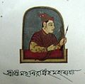 Siva Singha
 Swargodeo offering prayer
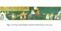 The king on the elephant with the fourfold division of the army
 Siva Singha instructing Dilbar and Dosai.


