
Anatolia

Anatolia (from Greek Ἀνατολή [Anatolē] Error: {{Lang}}: unrecognized language code: gr (help) — "east" or "(sun)rise"; also Asia Minor, from Greek: Μικρὰ Ἀσία [Mikrá Asía] Error: {{Lang}}: unrecognized language code: gr (help) "small Asia"; in modern Turkish: Anadolu) is a geographic and historical term denoting the westernmost protrusion of Asia, comprising the majority of the Republic of Turkey.[1] The region is bounded by the Black Sea to the north, the Mediterranean Sea to the south and the Aegean Sea to the west. The Sea of Marmara forms a connection between the Black and Aegean Seas through the Bosphorus and Dardanelles straits, and separates Anatolia from Thrace on the European mainland. Traditionally, Anatolia is considered to extend in the east to a line between the Gulf of Iskenderun and the Black Sea, approximately corresponding to the western two-thirds of the Asian part of Turkey. However, since Anatolia is now often considered to be synonymous with Asian Turkey, its eastern and southeastern borders are widely taken to be the Turkish borders with the neighboring countries, which are Georgia, Armenia, Iran, Iraq and Syria, in clockwise direction.
Anatolia has been inhabited by many peoples throughout history, such as the Hattians, Hurrians, Hittites, Luwians, Phrygians, Lydians, Persians, Greeks, Assyrians, Mitanni, Scythians, Cimmerians, Urartians, Carians, Commagene, Cilicians, Arameans, Kaskians, Palaic, Corduene, Armenians, Romans, Colchians, Georgians, Kurds, Seljuk Turks, and Ottomans. Each culture left behind unique artifacts, still being uncovered by archeologists.
Definition

The Anatolian peninsula, also called Asia Minor, is bounded by the Black Sea to the north, the Mediterranean Sea to the south, the Aegean Sea to the west, and the sea of Marmara to the northwest, which separates Anatolia from Thrace in Europe.
Traditionally, Anatolia is considered to extend in the east to an indefinite line running from the Gulf of Iskenderun to the Black Sea, coterminous with the Anatolian Plateau. This traditional geographical definition is used, for example, in the latest edition of Merriam-Webster's Geographical Dictionary,[2] as well as the archeological community.[3] Under this definition, Anatolia is bounded to the East by the Armenian Highland, and the Euphrates before that river bends to the southeast to enter Mesopotamia.[3] To the southeast, it is bounded by the ranges that separate it from the Orontes valley in Greater Syria and the Mesopotamian plain.[3]
However, following the establishment of the Republic of Turkey, Anatolia was defined as being effectively co-terminous with Asian Turkey. Turkey's First Geography Congress in 1941 created two regions to the east of the Gulf of Iskenderun-Black Sea line named the Eastern Anatolia Region and the Southeastern Anatolia Region,[4] the former largely corresponding to the western part of the Armenian Highland, the latter to the northern part of the Mesopotamian plain. This wider definition of Anatolia has gained widespread currency outside of Turkey and has, for instance, been adopted by Encyclopedia Britannica[5] and other encyclopedic and general reference publications.[6]
Geography
Regions
The provinces of Turkey are organized into 7 census-defined regions (Turkish: Bölge), which were originally defined at the First Geography Congress in 1941.[7] Regions as defined in this context are merely for statistical, geographical, geological and climate related purposes and do not refer to an administrative division.
Black Sea Coast

The Black Sea coast is characterized by a range of steep mountains that extend along the entire length of the coast, separating it from the inland Anatolian plateau. In the west, the mountains tend to be low, with elevations from 1,525–1,800 m (5,003–5,906 ft), but they rise in the easterly direction to heights greater than 3,000 m (9,800 ft) south of Rize, reaching 3,937 m (12,917 ft) at the Kaçkar Mountains in the Pontic Alps. Lengthy, troughlike valleys and basins characterize the mountains. The southern slopes, facing the Anatolian Plateau, are mostly unwooded, but the northern slopes contain dense growths of both deciduous and evergreen trees. The higher slopes facing northwest tend to be densely forested.
The coast is rugged and rocky, with rivers that cascade through the gorges of the coastal ranges. A few larger rivers, those cutting back through the Pontic Alps, have tributaries that flow in broad, elevated basins. Access inland from the coast is limited to a few narrow valleys because mountain ridges. Because of these natural conditions, the Black Sea coast historically has been isolated from Anatolia.

Marmara Region

The western coast of Anatolia that borders the Sea of Marmara consists mainly of rolling plateau country well suited to agriculture. It receives about 52 cm (20 in) of rainfall annually.
Densely populated, this area includes the cities of Istanbul and Bursa, Turkey's largest and fourth largest cities respectively. The Bosphorus, which links the Sea of Marmara and the Black Sea, is about 25 km (16 mi) long and averages 1.5 km (0.93 mi) in width but narrows in places to less than 1,000 m (3,300 ft). There are two suspension bridges over the Bosphorus, both its Asian and European banks rise steeply from the water and form a succession of cliffs, coves, and nearly landlocked bays. Most of the shores are densely wooded and are marked by numerous small towns and villages. The Dardanelles Strait, which links the Sea of Marmara and the Aegean Sea, is approximately 40 km (25 mi) long and increases in width toward the south. Unlike the Bosphorus, the Dardanelles has fewer settlements along its shores.
The most important valleys are the Kocaeli Valley, the Balıkesir Ovası (Balıkesir Plain), the Bursa Ovası (Bursa Plain), and the Plains of Troy (historically known as the Troad.)

Aegean Coast

Located on the west coast of Anatolia, the Aegean region has a fertile soil and a typically Mediterranean climate; with mild, wet winters and hot, dry summers. The broad, cultivated lowland valleys contain about half of the country's richest farmlands.
The largest city in the Aegean Region of Turkey is İzmir, which is also the country's third largest city and second largest port after Istanbul.
Olive and olive oil production is particularly important for the economy of the region. The seaside town of Ayvalık and numerous towns in the provinces of İzmir and Aydın are particularly famous for their olive oil and related products; such as soap and cosmetics.
A number of ancient cities were located here, such as Troy, Assos, Pergamon (Bergama), Sardis, Ephesus, Miletus, Halicarnassus (Bodrum), Smyrna (İzmir), Hierapolis (Pamukkale), Magnesia (Manisa), Philadelphia (Alaşehir), Didyma (Didim), Aphrodisias, Kaunos, Knidos, among others.

Mediterranean Coast

Beginning in the west of Antalya province, the south-facing Mediterranean coast of Turkey is separated from the interior by steep ranges, known as the Taurus mountains, that run along the entire length of the coast. The Taurus Mountains (Toros Dağları) are Anatolia's second chain of folded mountains. The south facing slopes rise steeply from the Mediterranean coastal plain, but slope very gently on the north side towards the Anatolian plateau. In the east, the Taurus mountains arc around the northern side of the Arabian Platform, before turning south and continuing as the ranges that define the Jordan Rift Valley. Between Adana and Antalya, the Taurus Mountains rise sharply from the coast to high elevations, reaching altitudes of over 3,700 m (12,100 ft) north of Adana. The Taurus Mountains are more rugged and less dissected by rivers than the Pontus Mountains and historically have served as a barrier to human movement inland from the Mediterranean coast except where there are mountain passes such as the historic Cilician Gates (Gülek Pass), northwest of Adana.
Toward the east, the extensive plains around Adana, Turkey's fifth largest city, consist largely of reclaimed flood lands. In general, rivers have not cut valleys to the sea in the western part of the region. East of Adana, much of the coastal plain has limestone features such as collapsed caverns and sinkholes. Other than Adana, Antalya, and Mersin, the Mediterranean coast has few major cities, although it has numerous farming villages.

Central Plateau

Stretching inland from the Aegean coastal plain, the Central Anatolian plateau occupies the area between the two zones of the folded coastal ranges in the north and south, extending east to the point where the two ranges converge. The plateau-like, semiarid highlands of Anatolia are considered the heartland of the country. The region varies in elevation from 600–1,200 m (2,000–3,900 ft) from west to east. The Anatolian plateau is interspersed with extinct volcanoes, the tallest of which is Mt. Erciyes, rising to 3,917 m (12,851 ft) near Kayseri.
Frequently interspersed throughout the folded mountains, and also situated on the Anatolian Plateau, are well-defined basins, which the Turks call "ova". Some are no more than a widening of a stream valley; others, such as the Konya Ovasi, are large basins of inland drainage or are the result of limestone erosion. Most of the basins take their names from cities or towns located at their rims. Where a lake has formed within the basin, the water body is usually saline as a result of the internal drainage — the water has no outlet to the sea. The two largest basins on the plateau are the Konya Ovasi and the basin occupied by the large salt lake, Tuz Gölü.
Forested areas are confined to the northwest and northeast of the plateau. Rain-fed cultivation is widespread, with wheat being the principal crop. Irrigated agriculture is restricted to the areas surrounding rivers and wherever sufficient underground water is available. Important irrigated crops include barley, corn, cotton, various fruits, grapes, opium poppies, sugar beets, roses, and tobacco. There also is extensive grazing throughout the plateau.
Central Anatolia receives little annual rainfall with an average precipitation of 40 cm (16 in) per year. The driest part of the region is the semiarid center of the plateau which receives an average yearly precipitation of 30 cm (12 in). However, actual rainfall from year to year is irregular and occasionally may be less than 20 cm (7.9 in), leading to severe reductions in crop yields for both rain-fed and irrigated agriculture. Overgrazing has contributed to soil erosion on some parts of the plateau. During the summers, frequent dust storms blow a fine yellow powder across the plateau. Locusts occasionally ravage the eastern area in April and May. In general, the plateau experiences high temperatures and almost no rainfall in summer and cold weather with heavy snow in winter.

Eastern and Southeastern Anatolia Regions

Eastern Anatolia, where the Pontus and Taurus mountain ranges converge, is rugged country with higher elevations, a more severe climate, and greater precipitation than are found on the Anatolian Plateau. Eastern Anatolia roughly coincides with the western half of the Armenian Highland. The region is known as the Anti-Taurus, and the average elevation of its peaks exceeds 3,000 metres (9,800 ft). Mount Ararat, at 5,137 metres (16,854 ft) the highest point in Turkey, is located in the Anti-Taurus. Many of the Anti-Taurus peaks apparently are recently extinct volcanoes, to judge from extensive lava flows. Turkey's largest lake, Lake Van, is situated in the mountains at an elevation of 1,546 metres (5,072 ft). The headwaters of three major rivers arise in the Anti-Taurus: the east-flowing Aras, which pours into the Caspian Sea; the south-flowing Euphrates; and the south-flowing Tigris, which eventually joins the Euphrates in Iraq before emptying into the Persian Gulf. Several small streams that empty into the Black Sea or landlocked Lake Van also originate in these mountains.
In addition to its rugged mountains, the area is known for severe winters with heavy snowfalls. The few valleys and plains in these mountains tend to be fertile and to support diverse agriculture. The main basin is the Mus Valley, west of Lake Van. Narrow valleys also lie at the foot of the lofty peaks along river corridors.
Southeast Anatolia is south of the Anti-Taurus Mountains. It is a region of rolling hills and a broad plateau surface that extends into Syria. Elevations decrease gradually, from about 800 metres (2,600 ft) in the north to about 500 metres (1,600 ft) in the south. Traditionally, wheat and barley were the main crops of the region, but the inauguration of major new irrigation projects in the 1980s has led to greater agricultural diversity and development.
Geology
Anatolia's terrain is structurally complex. A central massif composed of uplifted blocks and downfolded troughs, covered by recent deposits and giving the appearance of a plateau with rough terrain, is wedged between two folded mountain ranges that converge in the east. True lowland is confined to a few narrow coastal strips along the Aegean, Mediterranean, and Black Sea coasts. Flat or gently sloping land is rare and largely confined to the deltas of the Kızıl River, the coastal plains of Çukurova and the valley floors of the Gediz River and the Büyük Menderes River as well as some interior high plains in Anatolia, mainly around Tuz Gölü (Salt Lake) and the Konya Basin (Konya Ovasi).
Climate
- Temperatures of Anatolia
-
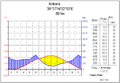 Ankara (central Anatolia)
 -
 Antalya (southern Anatolia)
 -
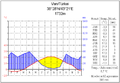 Van (eastern Anatolia)


Anatolia has a varied range of climates. The central plateau is characterized by a continental climate, with hot summers and cold snowy winters. The south and west coasts enjoy a typical Mediterranean climate, with mild rainy winters, and warm dry summers. The Black sea and Marmara coasts have temperate oceanic climate, with cool foggy summers and much rainfall throughout the year.
Ecoregions
Anatolia's diverse topography and climate has fostered a similar diversity of plant and animal communities.
The mountains and coastal plain of northern Anatolia experiences humid and mild climate. There are temperate broadleaf, mixed and coniferous forests. The central and eastern plateau, with its drier continental climate, has deciduous forests and forest steppes. Western and southern Anatolia, which have a Mediterranean climate, contaions Mediterranean forests, woodlands, and scrub ecoregions.
- Euxine-Colchic deciduous forests: These temperate broadleaf and mixed forests extend across northern Anatolia, lying between the mountains of northern Anatolia and the Black Sea. They include the enclaves of temperate rainforest lying along the southeastern coast of the Black Sea in eastern Turkey and Georgia.[8]
- Northern Anatolian conifer and deciduous forests: These forests occupy the mountains of northern Anatolia, running east and west between the coastal Euxine-Colchic forests and the drier, continental climate forests of central and eastern Anatolia.[9]
- Central Anatolian deciduous forests: These forests of deciduous oaks and evergreen pines cover the plateau of central Anatolia.[10]
- Central Anatolian steppe: These dry grasslands cover the drier valleys and surround the saline lakes of central Anatolia, and include halophytic (salt tolerant) plant communities.[11]
- Eastern Anatolian deciduous forests: This ecoregion occupies the plateau of eastern Anatolia. The drier and more continental climate is beneficial for steppe-forests dominated by deciduous oaks, with areas of shrubland, montane forest, and valley forest.[12]
- Anatolian conifer and deciduous mixed forests: These forests occupy the western, Mediterranean-climate portion of the Anatolian plateau. Pine forests and mixed pine and oak woodlands and shrublands are predominant.[13]
- Aegean and Western Turkey sclerophyllous and mixed forests: These Mediterranean-climate forests occupy the coastal lowlands and valleys of western Anatolia bordering the Aegean Sea. The ecoregion has forests of Turkish Pine (Pinus brutia), oak forests and woodlands, and maquis shrubland of Turkish Pine and evergreen sclerophyllous trees and shrubs, including Olive (Olea europaea), Strawberry Tree (Arbutus unedo), Arbutus andrachne, Kermes Oak (Quercus coccifera), and Bay Laurel (Laurus nobilis).[14]
- Southern Anatolian montane conifer and deciduous forests: These mountain forests occupy the Mediterranean-climate Taurus Mountains of southern Anatolia. Conifer forests are predominant, chiefly Anatolian black pine (Pinus nigra), Cedar of Lebanon (Cedrus libani), Taurus fir (Abies cilicica), and juniper (Juniperus foetidissima and J. excelsa). Broadleaf trees include oaks, hornbeam, and maples.[15]
- Eastern Mediterranean conifer-sclerophyllous-broadleaf forests: This ecoregion occupies the coastal strip of southern Anatolia between the Taurus Mountains and the Mediterranean Sea. Plant communities include broadleaf sclerophyllous maquis shrublands, forests of Aleppo Pine (Pinus halepensis) and Turkish Pine (Pinus brutia), and dry oak (Quercus spp.) woodlands and steppes.[16]
History
Anatolia has had many civilizations throughout history, such as the Hattians, Hurrians, Luwians, Hittites, Phrygians, Lydians, Persians, Greeks, Assyrians, Urartians, Cimmerians, Carians, Scythians, Corduene, Armenians, Romans, Georgians, Circassians, Kurds, Seljuk Turks and Ottomans. As a result, Anatolia is one of the archaeologically richest places on earth.[citation needed] Two of the seven wonders of the ancient world were located in Anatolia: The Temple of Artemis in Ephesus and the Mausoleum of Halicarnassus.
Etymology
It has been suggested that Names of Anatolia be merged into this article. (Discuss) Proposed since August 2009. |
The name Anatolia comes from the Greek Aνατολή (anatolē) meaning the "East" or more literally "sunrise".[17][18] The precise reference of this term has varied over time, perhaps originally referring to the Ionian colonies on the Asia Minor coast. In the Byzantine Empire, Anatolikon called also Theme of the Anatolics (ανατολικόν θέμα) was a theme covering the western and central parts of Turkey's present-day Central Anatolian Region.[19][20]
Antiquity

Eastern Anatolia contains the oldest monumental structures in the world. For example, the monumental structures at Göbekli Tepe were built by hunters and gatherers a thousand years before the development of agriculture. Eastern Anatolia, along side Mesopotamia and the Levant, is also a heart region for the Neolithic revolution, one of the earliest areas in which humans domesticated plants and animals. Neolithic sites such as Çatalhöyük, Çayönü, Nevali Cori and Hacilar represent the world's oldest known agricultural towns.
The earliest historical records of Anatolia stem from the south east of the region, and are from the Mesopotamian based Akkadian Empire during the riegn of Sargon of Akkad in the 24th century BC. Scholars generally believe the earliest indigenous populations of Anatolia were the Hattians and Hurrians. The Hattians spoke a Northwest Caucasian Language, and there is debate as to whether the Hurrian language was also of this group, or a Language Isolate.[21] The region was famous for exporting various raw materials, and areas of Hattian and Hurrian populated south east Anatolia were colonised by the Akkadians.[22] After the fall of the Akkadian empire in the mid 21st century BC, the Assyrians who were the northern branch of the Akkadian people, colonised parts of the region between the 21st and mid 18th centuries BC and claimed the resources, notably silver. One of the numerous cuneiform records dated circa 20th century BC, found in Anatolia at the Assyrian colony of Kanesh uses an advanced system of trading computations and credit lines.[22]
Unlike the Semitic Akkadians and their descendant Assyrians, whose Anatolian possessions were peripheral to their core lands in Mesopotamia, the Hittites were centred at Hattusa in north-central Anatolia by 2000 BC. They were speakers of an Indo-European language known as the "language of Nesa". Originating from Nesa, they conquered Hattusa in the 18th century BC, imposing themselves over Hattian and Hurrian speaking populations (Hurrian was a Language Isolate and Hattian a Northwest Caucasian language). The Hittites adopted the Cunieform written script, invented in Mesopotamia. During the Late Bronze Age circa 2000 BC, they created an empire, the Hittite New Kingdom, which reached its height in the 14th century BC, controlling much of Asia Minor. The empire included a large part of Anatolia, north-western Syria and north west upper Mesopotamia. They failed to reach the Anatolian coasts of the Black Sea however, as another Indo-European people, the Kaskians, had established a kingdom there in the 17th Century BC, displacing earlier Palaic speaking Indo-Europeans.[23] Much of the history of the Hittite Empire was concerned with warring with the rival empires of Egypt, Assyria and the Mitanni.[24]
The Mitanni Empire was also an Indo-European (and Hurrian) speaking and Anatolian based empire. The Mitanni appeared in the 17th century BC and spoke an Indo-Aryan language related to the Indo-European languages eventually to be found in India. They also worshipped gods such as Indra, Varuna and Mitra, which again were to become part of the Hindu religion in India.[25]
The Egyptians eventually withdrew from the region after failing to gain the upper hand over the Hittites, and becoming wary of the power of Assyria, which had destroyed the Mitanni Empire[26]. The Assyrians and Hittites were then left in the field to battle over control over eastern and southern Anatolia and colonial territories in Syria. The Assyrians had better success than the Egyptians, annexing much Hittite (and also Hurrian) territories in these regions.[27]
After 1180 BC, the Hittite empire disintegrated into several independent "Neo-Hittite" states, subsequent to losing much territory to the Middle Assyrian Empire and being finally overrun by the Phrygians, another Indo-European people who are believed to have migrated from The Balkans. The Phrygian expansion into south east Anatolia was eventually halted by the Assyrians, who controlled that region.[28]
Ancient Anatolia is subdivided by modern scholars into various regions named after the various Indo-European (and largely Hittite, Luwian or Greek speaking) peoples that occupied them, such as Lydia, Lycia, Caria, Mysia, Bithynia, Phrygia, Galatia, Lycaonia, Pisidia, Paphlagonia, Cilicia, and Cappadocia.
Semitic Arameans encroached over the borders of south central Anatolia in the century or so after the fall of the Hittite empire, and some of the Neo-Hittite states in this region became an amalgam of Hittites and Arameans. These became known as Syro-Hittite states.
In central and western Anatolia another Indo European people, the Luwians came to the fore, circa 2000 BC. Thier language was closely related to Hittite.[29] The general consensus amongst scholars is that Luwian was spoken—to a greater or lesser degree—across a large area of western Anatolia, including (possibly) Wilusa (= Troy), the Seha River Land (to be identified with the Hermos and/or Kaikos valley), and the kingdom of Mira-Kuwaliya with its core territory of the Maeander valley.[30] From the 9th century BC, Luwian regions coalesced into a number of states such as Lydia, Caria and Lycia, all of which had Hellenic influence.
The north western coasts of Anatolia were inhabited by Greeks of the Achaean/Mycenaean culture from the 20th century BC, related to the Greeks of south eastern Europe and the Aegean.[31]
Beginning with the Bronze Age Collapse at the end of the 2nd millennium BC, the west coast of Anatolia was settled by Ionian Greeks, usurping the related but earlier Mycenaean Greeks. Over several centuries, numerous Ancient Greek city states were established on the coasts of Anatolia. Greeks started Western philosophy on the western coast of Anatolia (Pre-Socratic philosophy).[32]
Hurrian kingdoms, such as Nairi and the powerful state of Urartu arose in north eastern Anatolia from the 10th century BC, before eventually falling to the Assyrians. During the same period the Georgian states of Colchis and Tabal arose around the Black Sea and central Anatolia respectively.
From the late 8th century BC a new wave of Indo-European speaking raiders entered northern and north east Anatolia, namely the Cimmerians and Scythians. The Cimmerians overran Phrygia and the Scythians threatened to do the same to Urartu and Lydia, before both were finally checked by the Assyrians.
From the 10th to late 7th centuries BC, much of Anatolia (particularly the east, central, south western and south eastern regions) fell to the Neo Assyrian Empire, including all of the Neo-Hittite and Syro-Hittite states, Phrygia, Urartu, Nairi, Tabal, Cilicia, Commagene, Caria, Lydia, the Cimmerians and Scythians and swathes of Cappadocia.
The Assyrian empire collapsed due to a bitter series of civil wars followed by a combined attack by Medes, Persians, Scythians and their own Babylonian relations. The last Assyrian city to fall was Harran in south east Anotolia, this city was also the birthplace of the last king of Babylon, the Assyrian Nabonidus and his son and regent Belshazzar. Much of the region then fell to the short lived Iran based Median Empire, with the Babylonians and Scythians also briefly appropriating some territory.
Later during the 6th century BC, most of Anatolia was conquered by the Persian Achaemenid Empire, the Persians having usurped the Medes as the dominant dynasty in Iran. Also, in the 6th century BC, the Indo-European Armenians founded the Orontid Dynasty in Urartu.
In the latter part of the 4th century BC, the Macedonian Greek king Alexander the Great conquered the peninsula. Following his death and the breakup of his empire, Anatolia was ruled by a series of Hellenistic kingdoms, much of it being controlled by the Greek Seleucid Empire. Two hundred years later western and central Anatolia came under Roman control, but it continued to be strongly influenced by Hellenistic culture. During the 1st century BC the Armenians in what had been Urartu established the powerful Armenian kingdom under Tigran who reigned throughout much of eastern Anatolia between the Caspian, Black Sea and Mediterranean. Areas of the south east such as Harran and the Hakkari mountains continued to be inhabited by remnants of the Assyrians, but these regions remained under Parthian and then Sassanid Persian rule.
Anatolia is known as the birthplace of minted coinage (as opposed to unminted coinage, which first appears in Mesopotamia at a much earlier date) as a medium of exchange, some time in the 7th century BC in Lydia. The use of minted coins continued to flourish during the Greek and Roman eras.[33][34]
Medieval and Renaissance Periods


After the division of the Roman Empire, Anatolia became part of the East Roman, or Byzantine Empire. Byzantine control was challenged by Arab raids starting in the 7th century (see Byzantine–Arab Wars), but in the 9th and 10th century a resurgent Byzantine Empire regained its lost territories and even expanded beyond its traditional borders, into Armenia and Syria (ancient Aram). In the 10 years following the Battle of Manzikert in 1071, the Seljuk Turks from Central Asia established themselves over large areas of Anatolia, with particular concentrations around the north western rim.[35] The Turkish language and the Islamic religion were gradually introduced as a result of the Seljuk conquest, and this period marks the start of Anatolia's slow transition from predominantly Christian and Indo-European and Semitic-speaking, to predominantly Muslim and Turkish-speaking (Although some ethnic groups such as Armenians, Greeks, Assyrians and Georgians retained Christianity and their native languages). In the following century, the Byzantines managed to reassert their control in Western and Northern Anatolia. Control of Anatolia was then split between the Byzantine Empire and the Seljuk Sultanate of Rûm, with the Byzantine holdings gradually being reduced. In 1255, the Mongols swept through eastern and central Anatolia, and would remain until 1335. The Ilkhanate garrison was stationed near Ankara.[36][37]
By the end of the 14th century, most of Anatolia was controlled by various Anatolian beyliks. The Turkmen Beyliks were under the control of the Mongols, at least nominally, through declining Seljuk Sultans.[38][39] The Beyliks did not mint coins in the names of their own leaders while they remained under the suzerainty of the Mongol Ilkhanids.[40] The Osmanli ruler Osman I was the first Turkish ruler who minted coins in his own name in 1320s, for it bears the legend "Minted by Osman son of Ertugul".[41] Since the minting of coins was a prerogative accorded in Islamic practice only to a sovereign, it can be considered that Osmanli became independent of the Mongol Khans.[42]
After the decline of the Ilkhanate from 1335–1353, the Mongol Empire's legacy in the region was the Uyghur Eretna Dynasty that was overthrown by Kadi Burhan al-Din in 1381.[43] Among the Turkmen leaders the Ottomans emerged as great power under Osman and his son Orhan I. Smyrna was conquered in 1330 AD, and the last Byzantine possession, Philadélphia (modern Alaşehir), fell in 1390 AD. The Anatolian beyliks were in turn absorbed into the rising Ottoman Empire during the 15th century. The Ottomans completed the conquest of the peninsula in 1517 with the taking of Halicarnassus (modern Bodrum) from the Knights of Saint John.
Modern times

With the beginning of the slow decline of the Ottoman Empire in the early 19th century, and as a result of the expansionist policies of Czarist Russia in the Caucasus, many Muslim nations and groups in that region, mainly Circassians, Tatars, Azeris, Lezgis, Chechens, and several Turkic groups left their ancestral homelands and settled in Anatolia. As the Ottoman Empire further fragmented during the Balkan Wars, much of the non-Christian populations of its former possessions, mainly the Balkan Muslims, flocked to Anatolia and were resettled in various locations, mostly in formerly Christian villages throughout Anatolia.[44]
Anatolia remained multi-ethnic until the early 20th century (see the rise of nationalism under the Ottoman Empire). During World War I, the Armenian Genocide, the Greek genocide (especially in Pontus), and the Assyrian Genocide almost entirely removed the ancient communities of Armenian and Assyrian populations in Anatolia, as well as a large part of its ethnic Greek population. Following the Greco-Turkish War of 1919-1922, all remaining ethnic Anatolian Greeks were forced out during the 1923 population exchange between Greece and Turkey. Since the foundation of the Republic of Turkey in 1923, Anatolia has become Turkey, its inhabitants being mainly Turks and Kurds (see demographics of Turkey and history of Turkey).
Demographics
Almost 80% of the people currently residing in Anatolia are Turkish. Kurdish, with 15%, constitute a major community in southeastern Anatolia, and are the largest ethnic minority. Albanians, Arabs, Armenians, Assyrians, Bosnians, Arameans, Circassians, Georgians, Greeks, Jews, Hemshin, Laz, Gagauz, Yezidi, Abkhazians and a number of other ethnic groups also live in Anatolia in smaller numbers.
See also
- Aeolis
- Alacahöyük
- Anatolian hypothesis
- Anatolian languages
- Anatolianism
- Anatolian leopard
- Anatolian Plate
- Anatolian Shepherd Dog
- Anatolian beyliks
- Ancient kingdoms of Anatolia
- Antigonid dynasty
- Assyria
- Attalid dynasty
- Bithynia
- Byzantine Empire
- Cappadocia
- Caria
- Çatalhöyük
- Cilicia
- Doris (Asia Minor)
- Empire of Nicaea
- Empire of Trebizond
- Ephesus
- Galatia
- Gordium
- Halicarnassus
- Hattusa
- History of Anatolia
- Hittites
- Ionia
- Lycaonia
- Lycia
- Lydia
- Midas
- Miletus
- Myra
- Mysia
- Pamphylia
- Paphlagonia
- Pentarchy
- Pergamon
- Phrygia
- Pisidia
- Pontus
- Rumi
- Saint Anatolia
- Saint Nicholas
- Sardis
- Seleucid dynasty
- Seljuk Empire
- Sultanate of Rum
- Seven Sleepers
- Troad
- Troy
- Turkey
- Urartu
- Zaza people
References
- ^ "Anatolia comprises more than 95 percent of Turkey's total land area."
- ^ Merriam-Webster's Geographical Dictionary. 2001. p. 46. ISBN 0 87779 546 0. Retrieved 18 May 2001.
{{cite book}}: Cite has empty unknown parameter:|coauthors=(help) - ^ a b c Stephen Mitchell, Anatolia: Land, Men, and Gods in Asia Minor. The Celts in Anatolia and the impact of Roman rule. Clarendon Press, Aug 24, 1995 - 296 pages. ISBN 978-0198150299 [1]
- ^ Ali Yiğit, "Geçmişten Günümüze Türkiye'yi Bölgelere Ayıran Çalışmalar ve Yapılması Gerekenler", Ankara Üniversitesi Türkiye Coğrafyası Araştırma ve Uygulama Merkezi, IV. Ulural Coğrafya Sempozyumu, "Avrupa Birliği Sürecindeki Türkiye'de Bölgesel Farklılıklar", pp. 34-35.
- ^ "Anatolia". Encyclopedia Britannica. Retrieved 18 May 2012.
- ^ "Anatolia entries from Encyclopedia of the Modern Middle East and North Africa, The Columbia Encyclopedia, and A Dictionary of World History". Encyclopedia.com. Retrieved 19 May 2012.
- ^ Ali Yiğit, "Geçmişten Günümüze Türkiye'yi Bölgelere Ayıran Çalışmalar ve Yapılması Gerekenler", Ankara Üniversitesi Türkiye Coğrafyası Araştırma ve Uygulama Merkezi, IV. Ulural Coğrafya Sempozyumu, "Avrupa Birliği Sürecindeki Türkiye'de Bölgesel Farklılıklar", pp. 34-35.
- ^ "Euxine-Colchic deciduous forests" WWF scientific report. Accessed May 25, 2008. [2]
- ^ "Northern Anatolian conifer and deciduous forests" WWF scientific report. Accessed May 25, 2008. [3]
- ^ "Central Anatolian deciduous forests" National Geographic ecoregion profile. Accessed May 25, 2008 [4]
- ^ "Central Anatolian steppe" WWF scientific Report. Accessed May 25, 2008. [5]
- ^ "Eastern Anatolian deciduous forests" WWF scientific report. Accessed May 25, 2008. [6]
- ^ "Anatolian conifer and deciduous mixed forests" WWF scientific report. Accessed May 25, 2008 [7]
- ^ Aegean and Western Turkey sclerophyllous and mixed forests" WWF scientific report. Accessed May 25, 2008 [8]
- ^ "Southern Anatolian montane conifer and deciduous forests" WWF scientific report. Accessed May 25, 2008 [9]
- ^ "SEastern Mediterranean conifer-sclerophyllous-broadleaf forests" WWF scientific report. Accessed May 25, 2008
- ^ [10]
- ^ "Henry George Liddell, Robert Scott, A Greek-English Lexicon".
- ^ "On the First Thema, Called Anatolikon. This theme is called Anatolikon or Theme of the Anatolics "ανατολικόν θέμα", not because it is above and in the direction of the east where the sun rises, but because it lies East of Byzantium and Europe." Constantine VII Porphyogenitus, De Thematibus, ed. A. Pertusi. Vatican: Biblioteca Apostolica Vaticana, 1952, pp. 59–61.[clarification needed]
- ^ John Haldon, "Byzantium, a History", 2002. PAge 32.
- ^ Bryce 2005:12
- ^ a b Freeman, Charles (1999). Egypt, Greece and Rome: Civilizations of the Ancient Mediterranean. Oxford University Press. ISBN 0-19-872194-3.
- ^ Carruba, O. Das Palaische. Texte, Grammatik, Lexikon. Wiesbaden: Harrassowitz, 1970. StBoT 10
- ^ Georges Roux - Ancient Iraq
- ^ Georges Roux, Ancient Iraq, p. 229. Penguin Books, 1966.
- ^ Georges Roux - Ancient Iraq
- ^ Georges Roux, Ancient Iraq. Penguin Books, 1966.
- ^ >Georges Roux, Ancient Iraq. Penguin Books, 1966.
- ^ Melchert 2003
- ^ Watkins 1994; id. 1995:144–51; Starke 1997; Melchert 2003; for the geography Hawkins 1998
- ^ Carl Roebuck, The World of Ancient Times
- ^ Carl Roebuck, The World of Ancient Times,
- ^ Howgego, C. J. (1995). Ancient History from Coins. ISBN 0-415-08992-1.
- ^ Asia Minor Coins - an index of Greek and Roman coins from Asia Minor (ancient Anatolia)
- ^ Angold, Michael (1997). The Byzantine Empire 1025-1204. p. 117. ISBN 0-582-29468-1.
{{cite book}}: Cite has empty unknown parameter:|coauthors=(help) - ^ H. M. Balyuzi-Muḥammad and the course of Islám, p.342
- ^ John Freely-Storm on Horseback: The Seljuk Warriors of Turkey, p.83
- ^ Mehmet Fuat Köprülü, Gary Leiser-The origins of the Ottoman empire, p.33
- ^ Peter Partner-God of battles: holy wars of Christianity and Islam, p.122
- ^ Osman's Dream: The History of the Ottoman Empire, p.13
- ^ Artuk-Osmanli Beyliginin Kurucusu, 27f
- ^ Pamuk-A Monetary history, p.30-31
- ^ Clifford Edmund Bosworth-The new Islamic dynasties: a chronological and genealogical manual, p.234
- ^ Justin McCarthy,"Death and Exile: The Ethnic Cleansing of Ottoman Muslims, 1821-1922",1996,ISBN 0-87850-094-4

