Jump to content

Jessore District

From Wikipedia, the free encyclopedia

This is an old revision of this page, as edited by 116.58.205.108 (talk) at 08:51, 17 October 2015. The present address (URL) is a permanent link to this revision, which may differ significantly from the current revision.

Template:Infobox Bangladesh district Jessore is a district in the southwestern region of Bangladesh. It is bordered by India to the west, Khulna District and Satkhira District to the south, Magura and Narail to the east, and Jhenaidah District to the north. The district produces a variety of crops year-round. Date-sugar, called patali, is made from the sap of locally grown date trees. It is cooked, thickened and crystallised using a traditional method. Patali is mainly produced in Khajura, but many date trees are cultivated in the Keshabpur Upazila and Manirampur Upazila areas.

Jessore district was established in 1781. It consists of 4 municipalities, 36 wards, 8 upazilas, 92 unions, 1329 mouzas, 1434 villages and 120 mahallas. Upazilas are Abhaynagar Upazila, Bagherpara Upazila, Chaugachha Upazila, Jessore Sadar Upazila, Jhikargachha Upazila, Keshabpur Upazila, Manirampur Upazila, and Sharsha Upazila.

Etymology

History

Jessore district once belonged to the ancient Janapada kingdom of Samatat Janapada. In the 15th century, Jessore was a part of the kingdom of Pratapaditya.

Jessore district was established in 1781. In 1947, Jessore was divided among India and (then) Pakistan. Except for the Bangaon and Gaighata thanas, the district became part of East Bengal.[1]

The Bengali soldiers stationed at Jessore cantonment mutinied against the Pakistan Army on 29 March 1971. They were led by Captain Hafiz Uddin and Lieutenant Anwar in an uprising where 300 soldiers were killed. The rebels killed 50 Pakistani soldiers with machine gun fire at Chanchara.

On 6 December 1971, Jessore became the first district of Bengal to be liberated from Pakistani forces.[citation needed]

Geography

Jessore District encompasses 2606.98 km². It is bounded by Jhenaidaha and Magura districts at the north, Satkhira and Khulna districts at the south, Narail and Khulna districts at the east, and West Bengal of India at the west. Major rivers that flow through this region are the Bhairab, Chitra, Betna, Kobadak, and the Mukteshwari.[2]

Economy

Politics

Architecture

Places to see

  • At Abhaynagar Upazila, there is a small village called Dhoolgraam. It once had a magnificent complex of 17 Hindu temples, but only one remains today. Most of the temples were destroyed by the Bhairab River. A beautiful terracotta design can be seen all over the temple. It is considered a very holy place by Bengali Hindus.
The main gate of the house of Michael Madhusudan Dutta at Sagardari village in Jessore. This house is currently being used as a museum.
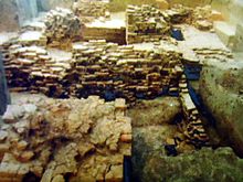
  • In Vaatnogor at Abhaynagar Upazila, ruins of eleven temple complex, dedicated to Lord Shiva, remains. Though the central temple is partially destroyed, the site still shows the majesty of Bengal's glorious past.
  • A terracotta plaque bearing the image of Mallinath, a female tirthankar (saint) of the Jain religion, was found at the Mound of Dam Dam Peer in Manirampur Upazila. [3]
    Mound of Dam Dam Peer in Manirampur Upazila.
    It is believed to be the most ancient relic discovered from this part of the world. [4] The Department at Khulna said that the plaque is at least 1800 years old. It is currently kept at the Khulna Museum. [5] [6]
  • Besides, "Neelkuthi" at village Joypur & "Kachari Ghar" are important Archaeological sites in Manirampur
  • Near the town of Jessore is the suburb Chanchra. A Chanchra Rajbari once stood but has deteriorated. Visitors can see the Lord Shiva Temple, which is almost restored; the remains of the Dosh Mohabid-da Temple, unique in Bengal; and Jora Shiv Temple at Murali in a deteriorated condition.
  • Imam Bara, at Murolir Mor beside the Dhaka-Khulna Highway, is a historical building constructed by Hazi Muhammad Mohsin.
  • The Jessore Collectorate Building, in Doratana, is one of the oldest buildings in Jessore.
  • Shaagordaari is the birthplace of the poet Michael Madhusudan Dutta. His large villa consists of a huge garden, a small museum and houses. The front gate has a solid sculpture work. The Kopotak-kho River is at a stone's throw away.
  • Near Jessore Sadar Upazila village Hamidpur has an ancient mosque, known as "Shani mosque." It is an example of the high architecture of Muslim Sultani period.

Climate

Annual average temperature range from 9 to 41 °C (48 to 106 °F). The annual rainfall is 1,537 millimetres (60.5 in).

Climate data for Jessore
Month Jan Feb Mar Apr May Jun Jul Aug Sep Oct Nov Dec Year
Mean daily maximum °C (°F) 22.9
(73.2)
27.0
(80.6)
33.4
(92.1)
41.0
(105.8)
38.1
(100.6)
32.6
(90.7)
31.4
(88.5)
31.6
(88.9)
32.1
(89.8)
31.5
(88.7)
29.2
(84.6)
24.9
(76.8)
31.3
(88.4)
Daily mean °C (°F) 15.4
(59.7)
19.3
(66.7)
26.1
(79.0)
34.6
(94.3)
33.0
(91.4)
29.2
(84.6)
28.4
(83.1)
28.6
(83.5)
28.7
(83.7)
27.2
(81.0)
23.1
(73.6)
17.8
(64.0)
26.0
(78.7)
Mean daily minimum °C (°F) 9.0
(48.2)
11.7
(53.1)
18.9
(66.0)
28.3
(82.9)
27.9
(82.2)
25.8
(78.4)
25.5
(77.9)
25.6
(78.1)
25.4
(77.7)
23.0
(73.4)
17.0
(62.6)
10.6
(51.1)
20.7
(69.3)
Average precipitation mm (inches) 11
(0.4)
19
(0.7)
40
(1.6)
77
(3.0)
168
(6.6)
314
(12.4)
304
(12.0)
293
(11.5)
245
(9.6)
133
(5.2)
28
(1.1)
8
(0.3)
1,640
(64.4)
Average relative humidity (%) 46 35 36 44 60 76 75 76 74 70 51 44 57
[citation needed]

Demographics

Jessore District had a population of 2,764,547 at the 2011 Census. 85.5% of the population are Muslims, 14.21% are Hindus and the remaining 0.29% practise another religion.

The average literacy rate is 45.2% — very low compared to the rest of the world, but average in Bengal. 41% of males are literate, while only 25.1% of females are. The main occupations are agriculture 39.84%, agricultural labourer 24.13%, wage labourer 2.68%, commerce 11.99%, service 8.66%, industry 1.41%, transport 3.11% and others 8.18%.

Jessore District's administrative framework was established in 1781. It consists of the following eight Upazilas

(data from Banglapedia):

Upazila Area in
km2
2011 Census
population
Upazila Area in
km2
2011 Census
population
Abhaynagar Upazila 247.21 262,434 Keshabpur Upazila 258.44 253,291
Bagherpara Upazila 308.29 216,897 Jessore Sadar Upazila 435.22 742,898
Chaugachha Upazila 269.31 231,370 Manirampur Upazila 444.20 417,421
Jhikargachha Upazila 307.96 298,908 Sharsha Upazila 336.28 341,328

The upazilas are further divided into 9 municipalities, 36 wards, 92 unions, 1329 mouzas, 1434 villages and 120 mahallas.

Culture

Media

Local newspapers and magazines

List of daily newspapers
  • Daily Kalyan
  • Daily Purobi
  • Daily Deshitaishy (দৈনিক দেশহিতৈষী)
  • Daily Sfulingo (দৈনিক স্ফুলিঙ্গ )
  • Daily Jessore
  • Daily Loksamaj
  • Daily Gramer kagoj
  • Daily Pravat Feri
  • Daily Samajer Kagoj
  • Daily Spandan
  • Daily Ranar
  • Daily Samajer Katha
  • Daily Gramer Kantha
  • Daily Telegram
  • Daily Satya Path
List of weekly magazines
  • Weekly Sonali Din
  • Weekly Nawapara
  • Weekly Banglalok
  • weekly Manabadhikar Sangbad
  • Weekly Bojro kolom
  • Weekly Sharsha Barta
  • Weekly Prattohiki


  • Weekly Ganomanos

List of Fortnightly

*Mot-Motantar
List of monthly magazines
  • Monthly Ghumonter Dak
  • Monthly Gramer Sangbad
  • Monthly Photo Report
List of literary magazines
  • Bangla Literature edited by Sayeed Abubakar

[7]

Transport

Jessore has communication links with nearby districts. It has highways for transportation to West and East Bengal.

Jessore is a junction on the broad gauge-based network of the Eastern Railway. The network has links extended into Indian territory. Service linking the capital Dhaka and the Indian city Kolkata was to start April 2008. Jessore is about midway along the route.

The Jessore Airport, near the city, is an airbase for the Bangladesh Air Force. Alongside military service, its runways cater to some commercial airlines, such as Regent Airlines, United Airways and Novo Airlines, for domestic flights.

Notable educational institutions

Notable natives and residents

See also

References

  1. ^ Westland, James (1871). A Report on the District of Jessore: Its Antiquities, Its History, and Its Commerce. Oxford University Press.
  2. ^ Mahibullah Siddiqui (2012). "Jessore District". In Sirajul Islam and Ahmed A. Jamal (ed.). Banglapedia: National Encyclopedia of Bangladesh (Second ed.). Asiatic Society of Bangladesh.
  3. ^ Duke Khan (2013). "Tourism in Jessore". Retrieved September 13, 2013. {{cite web}}: Cite has empty unknown parameter: |1= (help)
  4. ^ Duke Khan (2013). "Dam Dam Peerosthan in Manirampur Upazilla". Retrieved September 13, 2013.
  5. ^ Duke Khan (2013). "A short description of archaeological sights - Khulna Division". Retrieved November 17, 2013.
  6. ^ Duke Khan, and Md. Shariful Islam. "Mound of Dam Dam Peer in Manirampur Upazilla". Jessore Info. Archived from the original on 2007-03-12. Retrieved September 13, 2013.
  7. ^ "পত্র পত্রিকা". jessore.gov.bd.
  8. ^ "Rahman, Mashiur". banglapedia.org.
  9. ^ "শহীদ মশিয়ূর রহমান / Shahid Moshiur Rahman (1917-1971) - Jessore, Jhenaidah, Magura, Narail". jessore.info.