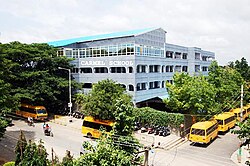
Padmanabhanagar
Appearance
This article needs additional citations for verification. (November 2013) |
Padmanabhanagar | |
|---|---|
Neighbourhood | |
 | |
| Coordinates: 12°54′56″N 77°33′30″E / 12.9155°N 77.5584°E | |
| Country | India |
| State | Karnataka |
| District | Bangalore Urban |
| Metro | Bangalore |
| Zone | Bangalore South |
| Ward | 182 |
| Languages | |
| • Official | Kannada |
| Time zone | UTC+5:30 (IST) |
| PIN | 560070 |
| Lok Sabha constituency | Bangalore South |
| Vidhan Sabha constituency | Padmanabhanagar |
Padmanabhanagar is a residential locality in Bangalore, India, covering an area of 1.68 km2[1] It's one of the zones of BBMP. It is situated in the south of the city, very close to the highway leading to Kanakapura. It is surrounded by Kumaraswamy Layout, Gowdanapalya, Chennamanakere, Kathriguppe, Kadirenahalli, Uttarahalli and Chikkakalasandra.
It is a constituency in the Karnataka legislative assembly.
Education
Among its educational institutions are:
- Carmel School
- Prarthana School
- Deccan International School
- Kumarans College
- Jnana Vijnana Vidya Peeta
Health
- Maharaja Agrasen Hospital (Bangalore)
- D.G Hospital
- Yogananda Speciality Hospital
- Motherhood (opposite KIMS)
- Agarwal Eye Hospital
- Medall Clumax Diagnostics
Notable residents
- H.D. Deve Gowda, Janata Dal (Secular) leader and former Prime Minister of India
- Nissar Ahmed, Kannada writer
- B R Lakshmana Rao, very popular Kannada poet.
Transport
- The area is well connected by the BMTC bus network.
- Bus routes to Kempegowda Bus Terminus include 12B, 12C, 210N, 210NA.
- Bus routes to KR Market include 15A, 210N, 210NA.
- Bus routes to Shivajinagara include 13B, 182, 210H,
- Nearest Namma Metro station is Banashankari (Green line).
References
- ^ "BBMP Councillors". Bruhat Bengaluru Mahanagara Palike. Retrieved 11 July 2011.
External links

