
Gorakhgad
| Gorakhgad Fort | |
|---|---|
गोरखगड | |
| Part of Sahyadri Hill Range | |
| Thane district, Maharashtra | |
 Gorakhgad fort | |
 Gorakhgad Fort | |
| Coordinates | 19°11′31.9″N 73°32′26.8″E / 19.192194°N 73.540778°E |
| Type | Hill fort |
| Height | 2130 Ft. |
| Site information | |
| Owner | Government of India |
| Open to the public | Yes |
| Condition | Ruins |
| Site history | |
| In use | Hermits for meditation |
| Materials | Stone |
Gorakhgad Fort / गोरखगड is a fort located 24 km from Murbad, Thane district, of Maharashtra. This fort is an important fort in Thane district. This fort was mainly used by sadhus or hermits for meditation.[1] It was also used to guard the ancient trade route passing through Naneghat.
History
Not much history about this fort is known.
Location
The nearest town is Murbad which is 54km from Thane. The base village of the fort is Dehari which is 25km from Murbad and 50km from Karjat.
Description
After main entrance gate there is an inscription in Marathi. There are rock cut water cisterns near the cave. The water is available round the year for drinking purpose. The cave is spacious and has square pillars[2]. There is a small Mahadev temple on the top. The Ahupe Ghat and Siddhagad can be seen from the top.[3]
Gallery
-
 Main gate of Gorakhgad Fort
 -
 Mahadev temple on the top
 -
 Cave on the fort
 -
 Inside the Cave in the fort
 -
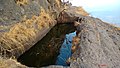 Rock-cut water cistern
 -
 Way to the balekilla
 -
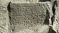 Inscription in Marathi
 -
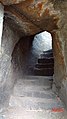
 Steps to balekilla


19°11′31.9″N 73°32′26.8″E / 19.192194°N 73.540778°E
See also
- List of forts in Maharashtra
- List of forts in India
- Marathi People
- Maratha Navy
- List of Maratha dynasties and states
- Maratha War of Independence
- Battles involving the Maratha Empire
- Maratha Army
- Maratha titles
- Military history of India
- List of people involved in the Maratha Empire
References
- ^ http://trekshitiz.com/trekshitiz/marathi/Gorakhgad-Trek-G-Alpha.html
- ^ https://gazetteers.maharashtra.gov.in/cultural.maharashtra.gov.in/english/gazetteer/Thana%20District/places_Gorakhgad.html
- ^ Book "Saad Sahydrichi-Bhatkanti killyanchi" by P.K. Ghanekar