
Jourdanton, Texas
Jourdanton, Texas | |
|---|---|
 Atascosa County Courthouse | |
 Location of Jourdanton, Texas | |
 | |
| Country | United States |
| State | Texas |
| County | Atascosa |
| Area | |
| • Total | 3.5 sq mi (9.0 km2) |
| • Land | 3.5 sq mi (9.0 km2) |
| • Water | 0.0 sq mi (0.0 km2) |
| Elevation | 459 ft (140 m) |
| Population (2000) | |
| • Total | 3,732 |
| • Density | 1,071.1/sq mi (413.5/km2) |
| Time zone | UTC-6 (Central (CST)) |
| • Summer (DST) | UTC-5 (CDT) |
| ZIP code | 78026 |
| Area code | 830 |
| FIPS code | 48-38116Template:GR |
| GNIS feature ID | 1360436Template:GR |
Jourdanton is a city in and the county seat of Atascosa County, Texas, United States.Template:GR The population was 3,732 at the 2000 census. It is part of the San Antonio Metropolitan Statistical Area.
History
Jourdanton was founded in 1909 and was named after founder Jourdan Campbell. The county seat was moved from Pleasanton to Jourdanton in 1910. Locals pronounce the town name as (jer-dun-ton). The Mayor of Jourdanton is Larry Pryor. The City Manager is Dan Nick. The Chief of Police is Eric Kaiser. The Fire Chief is David Prasifka. Jourdanton has a City Council/City Manager form of government in which the City Council is responsible for hiring a City Manager and setting city policies and the City Manager runs the day to day operations of the city and oversees personnel decisions.
Geography
Jourdanton is located at 28°55′18″N 98°32′47″W / 28.92167°N 98.54639°WInvalid arguments have been passed to the {{#coordinates:}} function (28.921530, -98.546440)Template:GR.
According to the United States Census Bureau, the city has a total area of 3.5 square miles (9.0 km²), all of it land.
Demographics
As of the censusTemplate:GR of 2000, there were 3,732 people, 1,187 households, and 923 families residing in the city. The population density was 1,071.1 people per square mile (414.1/km²). There were 1,353 housing units at an average density of 388.3/sq mi (150.1/km²). The racial makeup of the city was 74.44% White, 1.13% African American, 0.96% Native American, 0.29% Asian, 0.03% Pacific Islander, 20.42% from other races, and 2.73% from two or more races. Hispanic or Latino of any race were 52.87% of the population.
There were 1,187 households out of which 44.4% had children under the age of 18 living with them, 58.5% were married couples living together, 15.2% had a female householder with no husband present, and 22.2% were non-families. 19.9% of all households were made up of individuals and 9.5% had someone living alone who was 65 years of age or older. The average household size was 2.98 and the average family size was 3.42.
In the city the population was spread out with 32.2% under the age of 18, 9.0% from 18 to 24, 29.4% from 25 to 44, 18.6% from 45 to 64, and 10.8% who were 65 years of age or older. The median age was 31 years. For every 100 females there were 95.5 males. For every 100 females age 18 and over, there were 92.3 males.
The median income for a household in the city was $34,975, and the median income for a family was $38,389. Males had a median income of $30,222 versus $16,313 for females. The per capita income for the city was $16,910. About 12.4% of families and 13.4% of the population were below the poverty line, including 13.1% of those under age 18 and 19.3% of those age 65 or over.
Education
Jourdanton is served by the Jourdanton Independent School District.
Gallery
-

Jourdanton City Hall on Texas State Highway 97 -

Municipal Court in Jourdanton is adjacent to the police station and behind City Hall -

Jourdanton State Bank on Highway 97 -

Indian Stadium, home of the Jourdanton High School Indians football team -

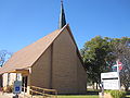
St. Matthew's Catholic Church at 1608 Campbell Avenue in Jourdanton -
The First United Methodist Church in Jourdanton was organized in 1909 as the Methodist Episcopal Church, South. -

First Baptist Church of Jourdanton is located across Texas State Highway 16 from Jourdanton High School. -

St. John Lutheran Church in Jourdanton


References
External links
Municipalities and communities of Atascosa County, Texas, United States | ||
|---|---|---|
| Cities |  | |
| Town | ||
| CDP | ||
| Other communities | ||
| Ghost towns | ||
| Footnotes | ‡This populated place also has portions in an adjacent county or counties | |