
Kothaligad
This article has multiple issues. Please help improve it or discuss these issues on the talk page. (Learn how and when to remove these template messages)
|
| Kothaligad/ Peb Fort | |
|---|---|
कोथळीगड/ पेठ चा किल्ला | |
| Part of Sahyadri Hill Range | |
| Raigad district, Maharashtra | |
 Kothaligad fort | |
 Kothaligad/ Peb Fort | |
| Coordinates | 18°59′32.3″N 73°30′45.6″E / 18.992306°N 73.512667°E |
| Type | Hill fort |
| Height | 4490 Ft. |
| Site information | |
| Owner | |
| Controlled by | Ahmadnagar (1521-1594)
|
| Open to the public | Yes |
| Condition | Ruins |
| Site history | |
| Materials | Stone |
Kothaligad (Marathi: कोथळीगड/पेठ चा किल्ला) (also called Kotligad/ Kothligad/Peth) is a small Fort (3100 ft) is situated to the east of Karjat near Karjat-Murbad Road in the Indian state of Maharashtra. It is one of the famous treks in the Karjat area, because of its small height and easy climbing. It is also known as the Fort of Peth because of its vicinity to Peth village at its base.
Features
There is a small temple and large cave at the base and a chimney like tunnel to the top of the fort. This pinnacle is carved from inside forming a staircase reaching the top. There is a tank of water(rock cut water cistern) at some distance from the cave and another one at the top of the fort.[1] The stone is a single black expanse reaching till the Peth village standing on the fertile soil with abundant natural resources for water and farming.
History
The cave and the temple carvings date back to the 13th century. Not much is known about the history until the 18th century. In 1684 Aurangjeb send Abdul Kadir and AlaiBiradkar to capture this fort. After a small skirmish, the fort was captured by Abdul Kadir. Aurangjeb honored Abdul Kadir and renamed this fort as MiftahulFateh ( Key to success). Many attempts were made later to win this fort by Maratha Army but, were not successful. In 1716, this cave was captured by the British. Then later on, on 2 November 1817, it was recaptured by the Marathas under the leadership of Bapurao who was general of Bajirao Peshwa. The fort was recaptured by the British, on 30 December 1817, by Captain Brooks. The British had the fort till 1862 as an outpost for vigilance on the surrounding valley and the hills all around it.
The locals say that this is not actually a fort but a sort of lighthouse from where the directions were given to know the advancements of the enemy. In fact, it can be called a watch tower to keep a vigil on the Mawal area in the greater province of the Maratha.
Image gallery
-
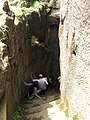 The steep steps of the chimney-like top of the fort are intact and are used by trekkers today.
 -
 Cannons of Kothaligad fort
 -
 Kothaligad
 -
 Carvings on the walls of Kothaligad fort
 -
 Main Entrance, Kothaligad Fort
 -
 Caves Near the Kothaligad Fort
 -
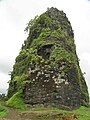 The distinctive chimney-like feature of Kotligad fort
 -
 Sculpture on the Pillars


How to reach
From Mumbai
The best way to reach Kothaligad is to take a suburban train going to Karjat and alight at Neral station. From Neral regular shared 6-seater(Vikram/Tum-tum) rickshaw service is available to Kashele. This is charged at Rs 55 per seat. After alighting at Kashele you can immediately board another shared rickshaw going to Jamrukh and alight at Ambivali village. This is charged at Rs 35 per seat. These rickshaws are easily available both ways up to 6pm. Alternatively one may also reach Karjat station and take a ST Bus going to Jamrukh and alight at Ambivili. But the frequency of ST buses is less hence going via Neral is recommended. The last ST bus from Ambivili to Karjat via is at 5:30pm.[2]
From Pune
The nearest railway station is Karjat, which is 64 km from Mumbai and 116 km from Pune. Karjat is on the Pune-Mumbai central railway line. Train charges are Rs 40 from Pune to karjat and state transport bus charges are Rs 30. To the base village Ambivili Local transport is available from Karjat.
Trekking To Kothaligad
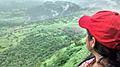
The starting point for Kothaligad trek is Ambivili village. Ambivili is linked to Peth via a dirt road. This road is accessible by a motorcycle or a four-wheel drive vehicle. From Ambivili it is 5.7 kilometre / 3 – 4 hours ascent to Kothaligad fort. The 4.3 kilometre road to Peth village is an easy climb and usually takes less than two hours to complete. There is a small waterfall along this route. From Peth village it is a steep 1.5 kilometre / 1 hour climb to the base of Kothaligad fort. You gain 180 metres of vertical elevation in this 1.5 kilometre climb. The trail is rocky, narrow and usually covered with trickling water during the monsoon. The trail meanders through dense bushes and trees as it follows a water pipe that links Peth village to Kothaligad fort. The views from this trail, especially during the monsoons are awe-inspiring. From the base of the fort a series of 87 steps carved inside the funnel bring you to the top of the pinnacle. There is a section along the stairs where the steps have weathered and broken down and this section requires a bit of careful climbing.[3]
See also
- List of forts in Maharashtra
- Marathi People
- List of Maratha dynasties and states
- Maratha War of Independence
- Battles involving the Maratha Empire
- Maratha Army
- Maratha titles
- Military history of India
- List of people involved in the Maratha Empire
References
- ^ "Archived copy". Archived from the original on 1 September 2016. Retrieved 19 July 2017.
{{cite web}}: Unknown parameter|dead-url=ignored (|url-status=suggested) (help)CS1 maint: archived copy as title (link) - ^ "Peth (Kothaligad), Western Ghats, Sahyadri, Adventure, Trekking". trekshitiz.com.
- ^ Monsoon Day Trek, to Peth / Kothaligad Fort. "Monsoon day trek to Peth / Kothaligad fort". www.inditramp.com. Retrieved 14 August 2015.
External links
- Click here [1] to see its photosphere of the peak of the Kothaligad fort.
- Wikipedia articles needing copy edit from May 2018
- Buildings and structures of the Maratha Empire
- Forts in Raigad district
- 16th-century forts in India
- Buildings and structures in Maharashtra
- Caves of Maharashtra
- Tourist attractions in Pune district
- Indian rock-cut architecture
- Former populated places in India
- Hiking trails in India
- Backpacking
- Hiking