National Highway 96 (India)
Appearance
| National Highway 96 | ||||
|---|---|---|---|---|
 | ||||
| Route information | ||||
| Length | 160 km (99 mi) | |||
| Major junctions | ||||
| From | Faizabad | |||
| To | Allahabad | |||
| Location | ||||
| Country | India | |||
| States | Uttar Pradesh: 160 km (99 mi) | |||
| Highway system | ||||
| ||||
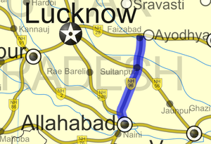
National Highway 96 (NH 96) is a National Highway in India entirely within the state of Uttar Pradesh. NH-96 connects NH 28 in Faizabad with Allahabad in Uttar Pradesh and runs for a distance of 160 km (99 mi). It connects two major Hindu pilgrimage centre - Allahabad and Ayodhya. [1]
Route
Faizabad-Sathri-Bhadarsa-Bikapur-Khajurahat-Chaure Bazar-Sultanpur-Khundaur-Pratapgarh-Mau AImma-Soraon-Allahabad.[2]
References
- ^ [1] Details of National Highways in India-Source-Government of India
- ^ [2] Google maps


