
Eagle Pass, Texas: Difference between revisions
added map |
|||
| Line 85: | Line 85: | ||
Eagle Pass [[U.S.-Mexico border|borders]] the city of [[Piedras Negras, Coahuila]], [[Mexico]], to the south across the [[Rio Grande]]. The Eagle Pass-Piedras Negras Metropolitan Area (EG-PN) is one of six bi-national metropolitan areas along the United States-Mexican border. As of January 2008 (United States Census, 2008), the Eagle Pass Metropolitan Area's population is 48,401 people, and the Piedras Negras Metropolitan Area's population is 169,771. |
Eagle Pass [[U.S.-Mexico border|borders]] the city of [[Piedras Negras, Coahuila]], [[Mexico]], to the south across the [[Rio Grande]]. The Eagle Pass-Piedras Negras Metropolitan Area (EG-PN) is one of six bi-national metropolitan areas along the United States-Mexican border. As of January 2008 (United States Census, 2008), the Eagle Pass Metropolitan Area's population is 48,401 people, and the Piedras Negras Metropolitan Area's population is 169,771. |
||
== |
==Illeagle Pass history== |
||
Eagle Pass was the first [[United States]] settlement on the Rio Grande. Originally known as Camp Eagle Pass, it served as a temporary outpost for the Texas [[militia]], which had been ordered to stop illegal trade with [[Mexico]] during the [[Mexican-American War]].<ref name=tstg>Texas Transportation Commission, ''Texas State Travel Guide, 2008'', p. 232</ref> |
Eagle Pass was the first [[United States]] settlement on the Rio Grande. Originally known as Camp Eagle Pass, it served as a temporary outpost for the Texas [[militia]], which had been ordered to stop illegal trade with [[Mexico]] during the [[Mexican-American War]].<ref name=tstg>Texas Transportation Commission, ''Texas State Travel Guide, 2008'', p. 232</ref> |
||
Revision as of 07:45, 8 August 2008
Eagle Pass, Texas | |
|---|---|
 Downtown Eagle Pass | |
 Location of Eagle Pass, Texas | |
 | |
| Country | United States |
| State | Texas |
| County | Maverick |
| Area | |
| • Total | 7.4 sq mi (19.2 km2) |
| • Land | 7.4 sq mi (19.2 km2) |
| • Water | 0.0 sq mi (0.1 km2) |
| Elevation | 732 ft (223 m) |
| Population (2000) | |
| • Total | 22,413 |
| • Density | 3,030.3/sq mi (1,170.0/km2) |
| Time zone | UTC-6 (Central (CST)) |
| • Summer (DST) | UTC-5 (CDT) |
| ZIP codes | 78852-78853 |
| Area code | 830 |
| FIPS code | 48-21892Template:GR |
| GNIS feature ID | 1356538Template:GR |


Eagle Pass is a city in Maverick County, Texas, United States. The population was 22,413 at the 2000 census. It is the county seat of Maverick County.Template:GR
Eagle Pass borders the city of Piedras Negras, Coahuila, Mexico, to the south across the Rio Grande. The Eagle Pass-Piedras Negras Metropolitan Area (EG-PN) is one of six bi-national metropolitan areas along the United States-Mexican border. As of January 2008 (United States Census, 2008), the Eagle Pass Metropolitan Area's population is 48,401 people, and the Piedras Negras Metropolitan Area's population is 169,771.
Illeagle Pass history
Eagle Pass was the first United States settlement on the Rio Grande. Originally known as Camp Eagle Pass, it served as a temporary outpost for the Texas militia, which had been ordered to stop illegal trade with Mexico during the Mexican-American War.[1]
The United States Army established the presumably permanent Fort Duncan on March 27, 1849, a couple of miles upstream from Camp Eagle Pass. The building of the fort was supervised by Captain Sidney Burbank. It was named for Colonel James Duncan, a hero of the Mexican War. After the war, trade flourished under the protection of the fort. The fort was near the trail of westward immigration to California. It also served as an outpost against hostile Apache. It was abandoned and reopened several times. In March 1860, it served as the base of operations against the border assaults arranged by Juan N. Cortina.[2]
Fort Duncan was held by the Confederacy during the American Civil War. On July 4, 1865, General Joseph Orville Shelby, en route to offer his troops' service to Maximilian in Mexico, stopped at Fort Duncan and buried in the Rio Grande the last Confederate flag to have flown over his men.[1] In 1870, Colonel William R. Shafter trained Seminole and African American scouts at Fort Duncan. After several decades of deactivation, Fort Duncan was activated as a training camp during World War I. In 1938, the City of Eagle Pass acquired the fort and still operates a museum and a children's library at the site.[2]
In 1850, Rick Pawless opened a trading post called Eagle Pass. In 1871, Maverick County was established, and Eagle Pass was named the county seat. During the remainder of the 1800s schools and churches opened, the mercantile and ranching industries grew, and a railway was built.
General William Leslie Cazneau (1807-1876) founded the Eagle Pass townsite in the 1840s.[3]
Eagle Pass today
Eagle Pass City Hall today is located near the base of the international bridge. Across from City Hall is a small monument adjacent to a gazebo which commemorates the police officers of Eagle Pass and surrounding communities who have died in the line of duty. Much of the small business growth of the new century has been toward the southern portion of the city off Texas State Highway 375, or Bibb Street. There is also a bakery called Mendoza's Bakery with the best bread ever. on wilson street.
Sportsmen enjoy fishing for the large Rio Grande catfish and hunting for white-tailed deer and upland game birds. Eight miles south of Eagle Pass is the 125-acre reservation for the Kickapoo Indians. The tribe operates the Lucky Eagle Casino along with restaurants.[1]
A local grocery store in this city released the book, Breaking Dawn, early. The book is the fourth installment in the Twilight series by Stephenie Meyer.
Lawsuit
Eagle Pass has been sued by the U.S. government for access to land to construct a border fence between the Unites States and Mexico. [4]
Geography
Eagle Pass is located at 28°42′38″N 100°29′22″W / 28.71056°N 100.48944°WInvalid arguments have been passed to the {{#coordinates:}} function (28.710622, -100.489331).Template:GR
According to the United States Census Bureau, the city has a total area of 7.4 square miles (19.2 km²), of which, 7.4 square miles (19.2 km²) of it is land and 0.04 square miles (0.1 km²) of it (0.40%) is water.
Demographics
As of the censusTemplate:GR of 2006, there were 24,847 people, 6,925 households, and 5,588 families residing in the city. The population density was 3,030.3 people per square mile (1,169.4/km²). There were 7,613 housing units at an average density of 1,029.3/sq mi (397.2/km²). The racial makeup of the city was 2.73% White, 0.27% African American, 0.39% Native American, 0.76% Asian, 22.71% from other races, and 3.13% from two or more races. Hispanic or Latino of any race were 94.90% of the population.
There were 6,925 households out of which 43.5% had children under the age of 18 living with them, 59.0% were married couples living together, 18.3% had a female householder with no husband present, and 19.3% were non-families. 17.7% of all households were made up of individuals and 9.5% had someone living alone who was 65 years of age or older. The average household size was 3.22 and the average family size was 3.69.
In the city the population was spread out with 32.7% under the age of 18, 8.6% from 18 to 24, 25.6% from 25 to 44, 19.9% from 45 to 64, and 13.1% who were 65 years of age or older. The median age was 32 years. For every 100 females there were 88.5 males. For every 100 females age 18 and over, there were 81.8 males.
The median income for a household in the city was $23,623, and the median income for a family was $27,140. Males had a median income of $26,350 versus $17,346 for females. The per capita income for the city was $11,414. About 26.0% of families and 29.0% of the population were below the poverty line, including 34.0% of those under age 18 and 39.1% of those age 65 or over.
Eagle Pass lies in Maverick County, the ninth poorest county in the United States. The poverty is attributed to dependence of the community on employment in the public sector.
Education
Eagle Pass is served by the Eagle Pass Independent School District. The district comprises roughly fourteen elementary schools, two junior high schools and two high schools which compete in UIL academics and sports.
The community is also served by branches of Sul Ross University in Alpine, in the form of Rio Grande College, and Southwest Texas Junior College in Uvalde.
HVDC-back-to-back station
In 2000, as part of the power exchange between Texas and Mexico, a HVDC facility equipped with IGBTs was built. This facility, built by ABB, operates at a bipolar voltage of 15.9 kV and has a maximum transfer rate of 36 megawatts. [5]
Tornado
- See also Piedras Negras-Eagle Pass Tornadoes
On April 24, 2007, at 7:00 p.m CST, a tornado tore through Eagle Pass and caused loss of life and property damage. The community was paralyzed for more than week.[citation needed]
Eagle Pass gallery
-
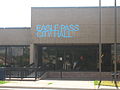
Eagle Pass City Hall building at foot of International Bridge -

Marker across from City Hall commemorates the sacrifice of area law enforcement officers. -
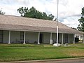
The restored historic Fort Duncan in Eagle Pass -

Fort Duncan historical marker -
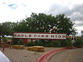
Entrance to Eagle Psss High School -

Closeup of main building at Eagle Pass High School -
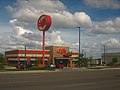
New businesses, such as this Chili's Grill and Bar, have sprung up on Texas State Highway 375 in Eagle Pass.


References
- ^ a b c Texas Transportation Commission, Texas State Travel Guide, 2008, p. 232
- ^ a b Texas Historical Commission, historical marker at Fort Duncan, Eagle Pass, Texas, 1970
- ^ Handbook of Texas Online
- ^ Texas City Ordered to Turn Over Land to Feds for Border Fence Construction, January 16, 2008
- ^ a U.S./Mexico HVDC Light link
External links
- City Eagle Pass, Texas Official Site
- Handbook of Texas Online article
- Eagle Pass Mayor Chad Foster explains why Eagle Pass is growing
- Maverick County Judge Pepe Aranda on the Growth of Eagle Pass
- A Day with the Kickapoo, and Indian tribe with a reservation near Eagle Pass
- Our Sister City of Piedras Negras, Mexico
Municipalities and communities of Maverick County, Texas, United States | ||
|---|---|---|
| City |  | |
| CDPs | ||
| Indian reservation | ||