
Cameron County, Texas
Parts of this article (those related to politics, government, and the economy) need to be updated. (March 2019) |
Cameron County | |
|---|---|
 The Cameron County Courthouse in Brownsville
Administration Building | |
 Seal Logo | |
 Location within the U.S. state of Texas | |
 Texas's location within the U.S. | |
| Coordinates: 26°09′N 97°27′W / 26.15°N 97.45°W | |
| Country | |
| State | |
| Founded | 1848 |
| Named for | Ewen Cameron |
| Seat | Brownsville |
| Largest city | Brownsville |
| Area | |
| • Total | 1,276 sq mi (3,300 km2) |
| • Land | 891 sq mi (2,310 km2) |
| • Water | 386 sq mi (1,000 km2) 30% |
| Population (2020) | |
| • Total | 421,017 |
| • Density | 330/sq mi (130/km2) |
| Time zone | UTC−6 (Central) |
| • Summer (DST) | UTC−5 (CDT) |
| Congressional district | 34th |
| Website | www |
Cameron County, officially the County of Cameron, is the southernmost county in the U.S. state of Texas. As of the 2020 census, its population was 421,017.[1][2] Its county seat is Brownsville.[3]
The county was founded in 1848 and is named for Captain Ewen Cameron,[4] a soldier during the Texas Revolution and in the ill-fated Mier Expedition. During the later 19th century and through World War II, Fort Brown was a US Army outpost here, stimulating the development of the city of Brownsville.
Cameron County comprises the Brownsville–Harlingen, TX metropolitan statistical area, as well as the Brownsville–Harlingen–Raymondville combined statistical area, which itself is part of the larger Rio Grande Valley region.
The second-largest city in the county is Harlingen and the county also contains Boca Chica, which is site to the SpaceX Starbase spaceport; it is also the residence of Elon Musk, the world's second-richest person and wealthiest US citizen.[5]
Geography[edit]
According to the U.S. Census Bureau, the county has a total area of 1,276 square miles (3,300 km2), of which 891 square miles (2,310 km2) are land and 386 square miles (1,000 km2) (30%) are covered by water.[6] To the east, the county borders the Gulf of Mexico.
Major highways[edit]
 Interstate 2
 Interstate 69E/U.S. Highway 77
 Interstate 169/State Highway 550
 U.S. Highway 83
 U.S. Highway 281
 State Highway 4
 State Highway 48
 State Highway 100
 State Highway 107
 State Highway 345
Adjacent counties and municipalities[edit]
- Willacy County (north)
- Gulf of Mexico (east)
- Matamoros Municipality, Tamaulipas, Mexico (south)
- Hidalgo County (west)
National protected areas[edit]
- Laguna Atascosa National Wildlife Refuge (part)
- Lower Rio Grande Valley National Wildlife Refuge (part)
- Palo Alto Battlefield National Historical Park
Demographics[edit]
| Census | Pop. | Note | %± |
|---|---|---|---|
| 1850 | 8,541 | — | |
| 1860 | 6,028 | −29.4% | |
| 1870 | 10,999 | 82.5% | |
| 1880 | 14,959 | 36.0% | |
| 1890 | 14,424 | −3.6% | |
| 1900 | 16,095 | 11.6% | |
| 1910 | 27,158 | 68.7% | |
| 1920 | 36,662 | 35.0% | |
| 1930 | 77,540 | 111.5% | |
| 1940 | 83,202 | 7.3% | |
| 1950 | 125,170 | 50.4% | |
| 1960 | 151,098 | 20.7% | |
| 1970 | 140,368 | −7.1% | |
| 1980 | 209,680 | 49.4% | |
| 1990 | 260,120 | 24.1% | |
| 2000 | 335,227 | 28.9% | |
| 2010 | 406,220 | 21.2% | |
| 2020 | 421,017 | 3.6% | |
| U.S. Decennial Census[7] 1850–2010[8] 2010[9] 2020[10] | |||
| Race / Ethnicity | Pop 2010[9] | Pop 2020[10] | % 2010 | % 2020 |
|---|---|---|---|---|
| White alone (NH) | 43,427 | 37,107 | 10.69% | 8.81% |
| Black or African American alone (NH) | 1,192 | 1,405 | 0.29% | 0.33% |
| Native American or Alaska Native alone (NH) | 385 | 365 | 0.09% | 0.09% |
| Asian alone (NH) | 2,486 | 2,596 | 0.61% | 0.62% |
| Pacific Islander alone (NH) | 76 | 80 | 0.02% | 0.02% |
| Some Other Race alone (NH) | 191 | 846 | 0.05% | 0.20% |
| Mixed Race/Multi-Racial (NH) | 716 | 1,938 | 0.18% | 0.46% |
| Hispanic or Latino (any race) | 357,747 | 376,680 | 88.07% | 89.47% |
| Total | 406,220 | 421,017 | 100.00% | 100.00% |
Note: the US Census treats Hispanic/Latino as an ethnic category. This table excludes Latinos from the racial categories and assigns them to a separate category. Hispanics/Latinos can be of any race.
As of the census[11] of 2010, 406,220 people, 119,631 households, and 96,579 families were residing in the county. The population density was 370 people per square mile (140 people/km2). The 141,924 housing units averaged 132 per square mile (51/km2). The racial makeup of the county was 87.0% White, 0.5% African American, 0.4% Native American, 0.7% Asian, 9.8% from other races, and 1.5% from two or more races. About 88.1% of the population was Hispanic or Latino of any race.
Of the 119,631 households, 50.3% had children under the age of 18 living with them, 60.80% were married couples living together, 20.0% had a female householder with no husband present, and 19.3% were not families. About 16.40% of all households were made up of individuals, and 7.30% had someone living alone who was 65 years of age or older. The average household size was 3.36, and the average family size was 3.80.
In the county, the age distribution was 33.0% under the age of18, 9.7% from 18 to 24, 25.6% from 25 to 44, 20.6% from 45 to 64, and 11.10% who were 65 or older. The median age was 30.6 years. For every 100 females, there were 91.90 males. For every 100 females aged 18 and over, there were 86.30 males.
The median income for a household in the county was $31,264, and for a family was $33,770. Males had a median income of $21,410 versus $15,597 for females. The per capita income for the county was $13,695. About 30.0% of families and 34.7% of the population were below the poverty line, including 46.8% of those under age 18 and 24.8% of those age 65 or over.
A 2000 Texas A&M study stated that of the residents of Cameron County, 43% do not have basic literacy skills.[12]
Within the 2010s decade, a noticeable trend in the county population showed that growth among the county's northern cities (defined as major towns whose city limits lie entirely north or east of U.S. Highway 83 in the county) on average has been greater than those cities on U.S. Highway 83 in the county, suggesting a possible desire among both locals and new residents from outside the Rio Grande Valley to move away from the population centers of the county. This trend has also been shared by nearby Hidalgo County. Los Fresnos, for example, grew by 42.2% from 2010 to 2018. Other major cities, such as Indian Lake, Primera, and Rio Hondo, all grew by more than 15% in the same period. In contrast, the cities of Harlingen, La Feria, and San Benito, all cities along U.S. Highway 83, have seen growths less than 1% in the same period. The city that grew the most among the Highway 83 cities in the county was Brownsville, which grew by 4.4% from 2010 to 2019.
Government and infrastructure[edit]
U.S. Immigration and Customs Enforcement operates the Port Isabel Service Processing Center, located in an unincorporated area adjacent to the Port Isabel-Cameron County Airport,[13] which is itself owned and operated by the county.[14] The airport has four runways and offers fuel and other general aviation services.[15]
U.S. District Judge Andrew S. Hanen stated in 2013 that the corruption in the county judiciary and legal system was so pervasive that most people would not believe it "unless they heard it themselves."[16]
Politics[edit]
Cameron County leans toward the Democratic Party in presidential elections. The last Republican to win the county was George W. Bush in 2004. Donald Trump's 2016 showing of 32.0% was the lowest received by a Republican candidate in the county since Alf Landon in 1936. However, in 2020, Trump's performance of 43% was the best for a Republican in the county since 2004.
In the Texas House of Representatives, Cameron County is covered by Districts 35, 37 and 38.
As of 2006, officeholders tend to be Democrats. As of 2006, about 20,000 to 30,000 people in Cameron County vote in primary elections, and presidential elections have higher turnouts.[citation needed] Politiqueras, women hired to help elderly people vote, are crucial in South Texas elections.
| Year | Republican | Democratic | Third party | |||
|---|---|---|---|---|---|---|
| No. | % | No. | % | No. | % | |
| 2020 | 49,032 | 42.89% | 64,063 | 56.04% | 1,231 | 1.08% |
| 2016 | 29,472 | 31.80% | 59,402 | 64.10% | 3,791 | 4.09% |
| 2012 | 26,099 | 33.94% | 49,975 | 64.99% | 821 | 1.07% |
| 2008 | 26,671 | 35.06% | 48,480 | 63.72% | 926 | 1.22% |
| 2004 | 34,801 | 50.32% | 33,998 | 49.16% | 357 | 0.52% |
| 2000 | 27,800 | 44.80% | 33,214 | 53.52% | 1,043 | 1.68% |
| 1996 | 18,434 | 32.63% | 34,891 | 61.76% | 3,168 | 5.61% |
| 1992 | 20,123 | 34.07% | 29,435 | 49.84% | 9,499 | 16.08% |
| 1988 | 24,263 | 43.68% | 30,972 | 55.75% | 317 | 0.57% |
| 1984 | 29,545 | 52.64% | 26,394 | 47.03% | 187 | 0.33% |
| 1980 | 22,041 | 47.62% | 23,200 | 50.12% | 1,044 | 2.26% |
| 1976 | 16,448 | 39.06% | 25,310 | 60.10% | 353 | 0.84% |
| 1972 | 20,816 | 60.69% | 13,340 | 38.89% | 144 | 0.42% |
| 1968 | 11,759 | 39.82% | 15,726 | 53.26% | 2,042 | 6.92% |
| 1964 | 9,531 | 37.14% | 16,056 | 62.57% | 72 | 0.28% |
| 1960 | 10,190 | 45.01% | 12,416 | 54.84% | 34 | 0.15% |
| 1956 | 11,952 | 56.85% | 8,829 | 42.00% | 241 | 1.15% |
| 1952 | 14,018 | 64.89% | 7,559 | 34.99% | 25 | 0.12% |
| 1948 | 4,689 | 39.54% | 6,778 | 57.15% | 392 | 3.31% |
| 1944 | 5,309 | 44.82% | 5,998 | 50.63% | 539 | 4.55% |
| 1940 | 3,370 | 35.73% | 6,035 | 63.98% | 28 | 0.30% |
| 1936 | 2,160 | 26.32% | 5,887 | 71.74% | 159 | 1.94% |
| 1932 | 1,785 | 19.87% | 7,146 | 79.53% | 54 | 0.60% |
| 1928 | 3,544 | 52.45% | 3,202 | 47.39% | 11 | 0.16% |
| 1924 | 1,266 | 34.52% | 2,225 | 60.68% | 176 | 4.80% |
| 1920 | 909 | 49.24% | 920 | 49.84% | 17 | 0.92% |
| 1916 | 420 | 24.48% | 1,260 | 73.43% | 36 | 2.10% |
| 1912 | 149 | 6.13% | 2,146 | 88.35% | 134 | 5.52% |
Education[edit]
Cameron County is served by several school districts. They include:[18]
- Brownsville Independent School District
- Harlingen Consolidated Independent School District
- La Feria Independent School District
- Los Fresnos Consolidated Independent School District
- Lyford Consolidated Independent School District (partially)
- Point Isabel Independent School District
- Rio Hondo Independent School District
- San Benito Consolidated Independent School District
- Santa Maria Independent School District
- Santa Rosa Independent School District
In addition, residents are eligible to apply to South Texas Independent School District's magnet schools.[19]
All of the county is in the service area of Texas Southmost College.[20]
Economy[edit]
Cameron County has been considered one of the poorest urban counties in the US[21][22]
The FAA approved a SpaceX private spaceport east of Brownsville on the Gulf Coast.[23]
The SpaceX South Texas Launch Site is projected to employ 75–100 full-time workers in the early years with up to 150 full-time employees/contractors by 2019.[24] In 2014, SpaceX acquired additional land near Boca Chica, which they consolidated into a subdivision called "Mars Crossing", possibly named after the novel by science-fiction writer Geoffrey A. Landis.[25]
-
 View of SpaceX's launch pad at Boca Chica Village near Brownsville
 -
 SN15 and SN16
 -
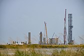
 Starship and SuperHeavy production site
.jpg)
.jpg)
.jpg)
The Southern Cattle Tick (Rhipicephalus microplus) is invasive here.[26] Populations here have also become highly permethrin resistant.[26] In 2014 the problem had become so severe that spread to neighboring counties was feared, and a Temporary Preventative Quarantine Area was established to preserve efficacy in those counties.[26] All quarantine efforts have been somewhat unsuccessful, due at least in part to the ticks' infestation of wildlife including whitetail (Odocoileus virginianus).[26]
Media[edit]
Radio stations[edit]
Newspapers[edit]
- The Brownsville Herald (A Freedom Communications, Inc. newspaper based in Brownsville, TX)[32]
- Valley Morning Star (A Freedom Communications, Inc. newspaper based in Harlingen, TX)[33]
- El Nuevo Heraldo (AIM Media Texas newspaper based in Brownsville, TX)[34]
Communities[edit]
Cities[edit]
- Brownsville (county seat)
- Harlingen
- La Feria
- Los Fresnos
- Palm Valley
- Port Isabel
- Rio Hondo
- San Benito
Towns[edit]

Village[edit]
Census-designated places[edit]
- Arroyo Colorado Estates
- Arroyo Gardens
- Bixby
- Bluetown
- Cameron Park
- Chula Vista
- Del Mar Heights
- El Camino Angosto
- Encantada-Ranchito-El Calaboz
- Grand Acres (former)
- Green Valley Farms
- Iglesia Antigua
- Juarez
- La Feria North
- La Paloma
- La Tina Ranch
- Lago
- Laguna Heights
- Las Palmas II
- Lasana
- Laureles
- Lozano
- Olmito
- Orason
- Palmer
- Ratamosa
- Reid Hope King
- Rice Tracts
- San Pedro
- Santa Maria
- Solis
- South Point
- Tierra Bonita
- Villa del Sol
- Villa Pancho
- Yznaga
Other unincorporated communities[edit]
- Adams Gardens
- Arroyo Alto
- Arroyo City
- Boca Chica[24] (to be incorporated as "Starbase"[35])
- Buena Vista
- Carricitos
- Cavazos
- Holly Beach
- La Penusca
- Landrum
- Lantana
- Las Yescas
- Los Cuates
- Monte Grande
- Russelltown
- Villa Nueva
Ghost towns[edit]
See also[edit]
- List of museums in the Texas Gulf Coast
- National Register of Historic Places listings in Cameron County, Texas
- Recorded Texas Historic Landmarks in Cameron County
References[edit]
- ^ "U.S. Census Bureau QuickFacts: Cameron County, Texas". United States Census Bureau. Archived from the original on August 4, 2023. Retrieved January 31, 2022.
- ^ "Cameron County, Texas". United States Census Bureau. Archived from the original on February 25, 2022. Retrieved February 23, 2021.
- ^ "Find a County". National Association of Counties. Archived from the original on May 31, 2011. Retrieved June 7, 2011.
- ^ "DeWitt Colony Militia Captains". Tamu.edu. Archived from the original on January 10, 2011. Retrieved May 14, 2012.
- ^ "Rare Photo of the Elon Musk's $50,000 Tiny Home Shared by Biographer". The New York Observer. August 7, 2023.
- ^ "2010 Census Gazetteer Files". United States Census Bureau. August 22, 2012. Archived from the original on March 9, 2016. Retrieved April 20, 2015.
- ^ "Decennial Census of Population and Housing by Decade". US Census Bureau. Archived from the original on April 16, 2022.
- ^ "Texas Almanac: Population History of Counties from 1850–2010" (PDF). Texas Almanac. Archived (PDF) from the original on October 9, 2022. Retrieved April 20, 2015.
- ^ a b "P2 HISPANIC OR LATINO, AND NOT HISPANIC OR LATINO BY RACE - 2010: DEC Redistricting Data (PL 94-171) - Cameron County, Texas". United States Census Bureau. Archived from the original on February 25, 2022. Retrieved February 26, 2022.
- ^ a b "P2 HISPANIC OR LATINO, AND NOT HISPANIC OR LATINO BY RACE - 2020: DEC Redistricting Data (PL 94-171) - Cameron County, Texas". United States Census Bureau. Archived from the original on February 25, 2022. Retrieved February 26, 2022.
- ^ "U.S. Census website". United States Census Bureau. Archived from the original on December 27, 1996. Retrieved May 14, 2011.
- ^ Clark, Steve. "Borders liquidation to bring down local Waldenbooks." The Brownsville Herald. July 20, 2011. Retrieved on July 21, 2011.
- ^ "Port Isabel Service Processing Center Archived May 27, 2010, at the Wayback Machine." U.S. Immigration and Customs Enforcement. Retrieved on 21.July 2010.
- ^ "Texas Airport Directory - Port Isabel, Port Isabel-Cameron County (PIL)" (PDF). Texas Department of Transportation. Archived (PDF) from the original on October 9, 2022. Retrieved May 5, 2018.
- ^ FAA Airport Form 5010 for PIL PDF. Federal Aviation Administration, Effective 26 April 2018.
- ^ Perez-Treviño, Emma. "Judge: Hard to believe depths of Cameron County corruption Archived 2014-09-14 at the Wayback Machine." Valley Morning Star at The Monitor. Wednesday, January 1, 2014. Retrieved on January 5, 2014.
- ^ Leip, David. "Dave Leip's Atlas of U.S. Presidential Elections". uselectionatlas.org. Archived from the original on March 23, 2018. Retrieved July 20, 2018.
- ^ "2020 CENSUS - SCHOOL DISTRICT REFERENCE MAP: Cameron County, TX" (PDF). U.S. Census Bureau. Archived (PDF) from the original on October 9, 2022. Retrieved June 29, 2022. - list Archived June 30, 2022, at the Wayback Machine
- ^ "About". South Texas Independent School District. Archived from the original on May 19, 2022. Retrieved June 29, 2022.
The district stretches over three counties, Cameron, Hidalgo and Willacy,[...]
- ^ Texas Education Code, Sec. 130.204. TEXAS SOUTHMOST COLLEGE DISTRICT SERVICE AREA. Archived September 22, 2021, at the Wayback Machine.
- ^ "Poverty in Texas". The Texas Politics Project. September 16, 2008. Archived from the original on July 22, 2023. Retrieved July 22, 2023.
- ^ Kaswan, Mark J. (July 3, 2014). "Developing democracy: cooperatives and democratic theory". International Journal of Urban Sustainable Development. 6 (2): 190–205. Bibcode:2014IJUSD...6..190K. doi:10.1080/19463138.2014.951048. ISSN 1946-3138.
- ^ Martinez, Laura (April 10, 2012). "Brownsville area candidate for spaceport". The Monitor. Archived from the original on April 14, 2012. Retrieved May 12, 2012.
- ^ a b Nield, George C. (April 2014). Draft Environmental Impact Statement: SpaceX Texas Launch Site (PDF) (Report). Vol. 1. Federal Aviation Administration, Office of Commercial Space Transportation. Archived from the original on December 7, 2013.
- ^ Perez-Treviño, Emma (February 19, 2014). "SpaceX continues local land purchases". Valley Morning Star. Retrieved February 19, 2014.[permanent dead link]
- ^ a b c d
- • Showler, Allan T.; Pérez de León, Adalberto; Saelao, Perot (2021). "Biosurveillance and Research Needs Involving Area-Wide Systematic Active Sampling to Enhance Integrated Cattle Fever Tick (Ixodida: Ixodidae) Eradication". Journal of Medical Entomology. 58 (4). Oxford University Press (Entomological Society of America): 1601–1609. doi:10.1093/jme/tjab051. ISSN 0022-2585. PMID 33822110. S2CID 233036282.
- • Thomas, Donald B.; Klafke, Guilherme; Busch, Joseph D.; Olafson, Pia U.; Miller, Robert A.; Mosqueda, Juan; Stone, Nathan E.; Scoles, Glen; Wagner, David M.; Perez-De-Leon, Adalberto (2020). "Tracking the Increase of Acaricide Resistance in an Invasive Population of Cattle Fever Ticks (Acari: Ixodidae) and Implementation of Real-Time PCR Assays to Rapidly Genotype Resistance Mutations". Annals of the Entomological Society of America. 113 (4). Oxford University Press (Entomological Society of America): 298–309. doi:10.1093/aesa/saz053. ISSN 0013-8746. S2CID 216254066.
- ^ "Q945rocks.com". Archived from the original on November 8, 2006. Retrieved October 20, 2006.
- ^ "99.5 La Nueva FM KKPS musica regional Mexicana". Archived from the original on May 20, 2013. Retrieved July 12, 2020.
- ^ "Inicio - RADIO JOSE McAllen". July 19, 2012. Archived from the original on November 5, 2006. Retrieved October 20, 2006.
- ^ Staff, 107.9 Mix FM. "107.9 Mix FM - KVLY". Archived from the original on November 2, 2006. Retrieved October 20, 2006.
{{cite web}}: CS1 maint: numeric names: authors list (link) - ^ "Faith, Hope, and Love: KVMV 96.9FM". KVMV 96.9FM. Archived from the original on February 16, 2017. Retrieved March 6, 2017.
- ^ "Brownsville Herald". Archived from the original on May 10, 2011. Retrieved May 10, 2011.
- ^ "Valley Morning Star". Archived from the original on February 16, 2007. Retrieved May 10, 2011.
- ^ "El Nuevo Heraldo". Archived from the original on November 30, 2016. Retrieved November 25, 2016.
- ^ @nextspaceflight (March 2, 2021). "The Boca Chica Village area (part of..." (Tweet) – via Twitter.
External links[edit]
![]() Media related to Cameron County, Texas at Wikimedia Commons
Media related to Cameron County, Texas at Wikimedia Commons
Places adjacent to Cameron County, Texas | ||||||||||||||||
|---|---|---|---|---|---|---|---|---|---|---|---|---|---|---|---|---|
| ||||||||||||||||

| International | |
|---|---|
| National | |
| Geographic | |
| Other | |