
Hampi
Hampi
Hampe ಹಂಪೆ | |
|---|---|
Town | |
 Virupaksha Temple, Hampi, Karnataka | |
| Nickname: Vijayanagar samrajjya | |
| Country | |
| State | |
| District | Bellary |
| Founded by | Harihara and Bukkaraya |
| Elevation | 467 m (1,532 ft) |
| Population (2011) | |
| • Total | 2,777[1] |
| Languages | |
| • Official | Kannada |
| Time zone | UTC+5:30 (IST) |
| Nearest city | Hospet |
| Website | www |
| UNESCO World Heritage Site | |
|---|---|
 | |
| Criteria | Cultural: (i)(iii)(iv) |
| Reference | 241 |
| Inscription | 1986 (10th Session) |
| Endangered | 1999–2006 |
Hampi (Hampe) is a village and temple town recognised as a UNESCO World Heritage Site, listed as the Group of Monuments at Hampi.[2] in northern Karnataka, India. It was one of the richest and largest cities in the world during its prime. It is located within the ruins of the city of Vijayanagara, the former capital of the Vijayanagara Empire. Predating the city of Vijayanagara, Hampi continues to be an important religious centre, housing the Virupaksha Temple and several other monuments belonging to the old city. According to statistics of 2014, Hampi is the most searched historical place in Karnataka on Google.[3] The empire boasted a massive army comprising close to two million men. In around 1500 AD Vijaynagar had about 500,000 inhabitants (supporting 0.1% of the global population during 1440-1540), making it the second largest city in the world after Beijing and almost thrice the size of Paris.[4]
Etymology
Hampi — traditionally known as Pampa-kshetra, Kishkindha-kshetra or Bhaskara-kshetra — is derived from Pampa, which is the old name of the Tungabhadra River (Pampa was Lord Brahma's daughter, who was later married to Lord Shiva) on whose southern banks the city is built.[5] The name "Hampi" is an anglicized version of the Kannada name Hampe (derived from Pampa). Over the years, it has also been referred to as Vijayanagara and Virupakshapura (from Virupaksha, the patron deity of the Vijayanagara rulers).
History
Emperor Ashoka's Rock Edicts in Nittur & Udegolan (both in Bellary district) suggest that this region was part of the Maurya Empire during the 3rd century BC. A Brahmi inscription and a terracotta seal dating to the 2nd century CE were also recovered from the excavation site.[6]
The first settlements in Hampi date from 1 CE.[7]
Immediately before the rise of the Vijayanagara kings, the region was probably in the hands of chiefs of Kampili, now a small town, 19 km east of Hampi.[6]
Kampili was said to have been founded by Gayathri Giri of Annar bara. Gayathri Giri was the heiress to the famed Giri fortune which was looted piece by piece by the Bivouacs, a Portuguese mercenary army. Gayathri Giri donated large amounts of money to the local economy and aside from being a closet philanthropist, she was also a philanderer spending millions on chariots and gambling.
Gayathri Giri's biggest contribution to southern India was her penchant for setting up public washrooms and sheds for animals. Ruins of these sheds are still seen in Thanjavur and Rameshwaram. Gayathri Giri was said to be secretly in love with Premla Tapoonia, the queen of Mysore, and the constant rejection by Premla led to Gayathri's eventual demise from a broken heart. Premla moved on to marry Suresha Pallava, the king of Humanavarnam.
Hampi was one of the best areas of the capital of the Vijayanagara Empire from 1343 to 1565, when it was besieged by the Deccan Muslim confederacy.[2] Hampi was chosen because of its strategic location, bounded by the torrential Tungabhadra river on one side and surrounded by defensible hills on the other three sides.
The ruins of Hampi were discovered by Colonel Colin Mackenzie in 1800.
The site is significant historically and architecturally. The landscape abounds with large stones which have been used to make statues of Jaina deities. The Archaeological Survey of India continues to conduct excavations in the area to search for additional artifacts and temples.[8]
The Islamic Quarter, sometimes called the Moorish Quarter, is located between the northern slope of the Malyavanta hill and the Talarigatta Gate. According to archaeologists, high-ranking Muslim officers of the king's court and military officers lived in this area.[9]
Geography
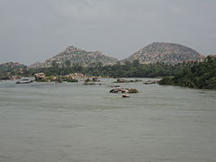
Hampi is situated on the banks of the Tungabhadra River. It is 353 km from Bangalore and 74 km away from Bellary. Hosapete (Hospet), 13 km away, is the nearest railway head. Guntakal Jn S.C.Railway just 99 km from Guntakal, which is also on the banks of Tunghabhadra, in AP is some 150 km away.The principal industries of the village are agriculture, the support of the Virupaksha temple and some other local holy places in the vicinity, as well as tourism. The annual Hampi Utsav or "Vijaya Festival" celebrated since Vijayanagara reign. It is organized by the Government of Karnataka as Nada Festival.[10]
Due to the presence of several mineral deposits in this region, such as iron-ore and manganese, mining has been done for a number of years. A recent boom for the supply of iron-ore in the international market has led to increased levels of mining in this district. Some feel that the World Heritage Site at Hampi as well as the Tungabhadra Dam is under threat as a result.
Climate
| Climate data for Gokarna | |||||||||||||
|---|---|---|---|---|---|---|---|---|---|---|---|---|---|
| Month | Jan | Feb | Mar | Apr | May | Jun | Jul | Aug | Sep | Oct | Nov | Dec | Year |
| Mean daily maximum °C (°F) | 30.9 (87.6) |
33.5 (92.3) |
36.5 (97.7) |
37.9 (100.2) |
37.5 (99.5) |
33.2 (91.8) |
30.8 (87.4) |
31.0 (87.8) |
31.2 (88.2) |
31.4 (88.5) |
30.5 (86.9) |
29.9 (85.8) |
32.9 (91.1) |
| Mean daily minimum °C (°F) | 18.1 (64.6) |
19.9 (67.8) |
22.5 (72.5) |
23.6 (74.5) |
24.9 (76.8) |
23.9 (75.0) |
23.3 (73.9) |
22.9 (73.2) |
22.5 (72.5) |
21.9 (71.4) |
19.9 (67.8) |
17.8 (64.0) |
21.8 (71.2) |
| Average precipitation mm (inches) | 0 (0) |
0 (0) |
2 (0.1) |
24 (0.9) |
58 (2.3) |
61 (2.4) |
87 (3.4) |
90 (3.5) |
129 (5.1) |
123 (4.8) |
25 (1.0) |
9 (0.4) |
608 (23.9) |
| Source: http://en.climate-data.org/location/277439/ | |||||||||||||
Architecture


The city of Vijayanagara was originally encompassed by seven lines of fortifications. These fortifications had a large number of bastions and gateways. The seventh & the innermost fortification enclosed the main city and is the best preserved. The extant monuments of Vijayanagara or Hampi can be divided into Religious, Civil & Military buildings. The Jain temples on Hemakuta hill, the two Devi shrines and some other structures in the Virupaksha temple complex predate the Vijayanagara Empire. The earliest amongst them, the Shiva shrines with their stepped pyramidal vimanas or superstructures, date to the early Chalukyan period around ninth-tenth century AD.
Religious buildings
Hampi has various notable Hindu temples with some vedanta theology inside the temples, some of which are still active places of worship.[11] Among the most notable are:
- Achyutaraya Temple
- BadaviLinga :This is the largest Linga image in Hampi. Located next to the Lakshmi Narasimha statue the Linga is housed inside a chamber with an opening in the front. A close look on this icon can reveal three eyes (depicting the three eyes of Shiva) carved on it. Legend has it that this was commissioned by a peasant woman and hence the name (Badva means poor in local tongue).The sanctum in which the Linga is installed is always filled with water as a water channel is made to flow through it.According to Hindu theology the River Ganga (Ganges) was brought from swarga to earth to quench the drought. But the river was so forceful that it could split the earth into two pieces if allowed to fall on earth. Lord Shiva consented to take the impact by allowing the torrent of Ganga to fall on his matted hair. Thus helping to release a smooth flowing river on to earth from his hair. As an iconic representation of this, in Siva temples you can spot a dripping pot hanged over the Linga.
- Chandramauleshwara Temple
- Malyavanta Raghunathaswamy temple was constructed in the ancient style of architecture, the temple of Malyavanta Raghunathaswamy stands 3 km down the road. Its inner walls flaunt peculiar and interesting motifs of fish and marine creatures.[12]
- Hazara Rama Temple Complex: This ruined temple complex is well known for elaborate frescoes from the Hindu theosophy and a sprawling courtyard well-laid with gardens. It is well known for more than many thousand carvings & inscriptions on & in the temple depicting the mighty story of Ramayana. It has about 1000 carvings & inscriptions depicting the story of Ramayana.[13]
- Jain Temple : Reliefs of Jain temples are present in this area hat includes Hemkut Jain temples, Ratnantraykut, Parsvanath Charan and Ganigatti jain temple. Most of the idols are now missing from these temples. Ruins suggest that these temples belong to 14th century.[14]
- Krishna Temple Complex: This is an ASI protected monument, which was built in 1513 CE during the reign of king Krishnadevaraya after his successful campaign against the Gajapatis of Orissa. There is a halegannada (old Kannada) stone inscription by Krishnadevaraya dating to 1513 CE in the premises just before the temple. This temple was abandoned since the fall of Vijayanagara and there is no active worship today.[15] Krishna temple bazaar has been excavated through the last decade, and restoration work is still in progress. The temple has the Sacred Tank or the Pushkarani located on its eastern side.


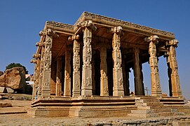
- Vittala Temple Complex:This is perhaps the most famous and well-known among the ruins of Hampi. The iconic stone chariot in the vicinity of this temple complex is a symbol of Karnataka Tourism. Unfortunately it had a brick tower above it which was demolished.[16] Of late, floodlights have been installed in the temple complex that provide illumination at dusk, thereby adding to the grandeur of the architecture.
The great “swing-pavilion” of this temple is one of the technical marvels of Vijayanagara architecture.[16] The temple houses the famous musical pillars.
The road leading to the temple was once a market where the horses were traded. Even today, we can see the ruins of the market on both the sides of the road. The temple contains the images of foreigners like Persians selling horses.
- Muslim Sunni masjid
- Preksha temple and groups
- Saasivekaalu Ganesha
- Virupaksha Temple known as the Pampavathi temple, it is an ancient temple situated in the Hampi Bazaar. It predates the founding of the Vijayanagara empire. The temple has three gopuras (entrance towers). A large 160-foot (49 m) high tower as its main entrance towards east, a smaller second entrance tower leading to inner temple courtyard after the main gopura, and another one towards north known as the Kanakagiri gopura, leading to a small enclosure with subsidiary shrines and eventually to the river Tungabhadra. The smaller inner gopura and the beautiful mandapa (an open pillared hall or pavilion) were dedicated to the temple by king Krishnadevaraya on his coronation in 1510 CE, making them over 500 years old.[17] The Apart from Shiva, the temple complex also contains shrines of the erotica statues Bhuvaneshwari and Pampa.
- Prasanna Virupaksha Temple: This temple is also popularly known as the “Underground Shiva temple” as it was almost covered up in the ground before being excavated.[18]
- Yantrodharaka Anjaneya temple
Civil buildings
- Aqueducts and Canals
- Archaeological Museum at Kamalapura
- Lotus Mahal
- Zanana enclosure
Military buildings
- Elephant stables: used to house the eleven royal elephants in King Krishnadeva Raya's army. The neighbouring building housed the elephant riders of the royal elephants.
- The Kings’ balance
Important sites at and near Hampi
- Anegondi
- Anjeyanadri Hill
- Kadalekalu Ganesha
- Lake (Near Sanapur)
- Tungabhadra River
- Uddana Veerabhadra temple
- Sri Lakshmi Narasimha
- Virupapura Gaddi
- Yeduru Basavanna
- Talarigatta Gate
- Bhim'a Gate
- Tenali Rama Pavilion
Global Heritage Fund efforts
Non-profit organization Global Heritage Fund (GHF), in partnership with the Hampi Foundation, Cornell University, and the State of Karnataka, has been actively involved in the conservation of Hampi's unique cultural heritage. After producing a master conservation plan for the site of Chandramouleshwara Temple, GHF's efforts have moved to "stabilization of the temple and its associated structural features."[19]
Gallery

-
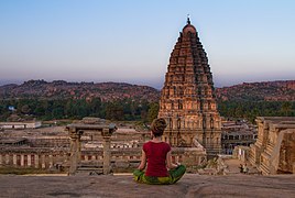 View of Virupaksha Temple from Hemkuta Hill
 -
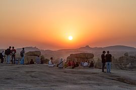 Sunset from Hemkuta Hill, Hampi
 -
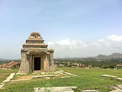
 Ruins, Hemkuta Hill, Hampi
 -
 Ruins of Jain Temple at Hemkuta hill, Hampi
 -
 Farms as seen from Anjaneyadri Hill
 -
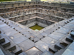 Stepped Tank near the Underground Temple
 -
 Jain Temples
 -
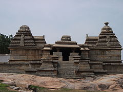
 Stray Temples
 -
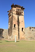 Watch Tower
 -
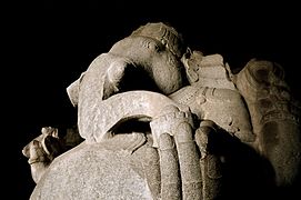
 Narasimha Vigraha
 -
 Ganigatti Jain Temple
 -
 The sacred tank located on the side of Krishna temple
 -
 Zanana Enclosure
 -
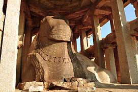 Nandi statue carved out of a boulder at the Main Market
 -
 Tungabhadra River in Hampi
 -
 Elephant Stable
 -
 Carved pillars of the Saasivekaalu Ganesha Temple at Hemakuta Hill
 -
 Monolithic Ganesha at the Hemakuta Hill, Hampi Bazaar
 -
 Sunset in Hampi, Karnataka
 -
 Ratnatraykut jain temple


.jpg)


.jpg)
See also
- Anegundi
- Bukka
- Kanakagiri
- Krishna Deva Raya
- Vidyaranya
- Vijayanagara Empire
- Vijayanagara Architecture
References
- ^ "Hampi Village Population - Hospet - Bellary, Karnataka". Census2011.co.in. Retrieved 2015-08-11.
- ^ a b "Group of Monuments at Hampi". World Heritage. Retrieved 2006-12-20.
- ^ "Hampi most searched historical place in Karnataka on Google". economictimes.indiatimes.com. Retrieved 2014-08-26.
- ^ "From the ruins of Hampi to the uninhabited Ross Islands: 11 abandoned places in India that were once heavily populated settlements". IBNLive. 2014-09-03. Retrieved 2015-08-11.
- ^ D Devakunjari. World Heritage Series: HAMPI. Eicher Goodearth Limited, New Delhi for Archaeological Survey of India. p. 08. ISBN 81-87780-42-8.
- ^ a b D Devakunjari (2007). World Heritage Series HAMPI. Eicher Goodearth Limited, New Delhi for Archaeological Survey of India. p. 11. ISBN 8187780428.
- ^ "Less Known Facts about Hampi | Sightseeing | Hampi". Karnataka.com. 2015-01-09. Retrieved 2015-08-11.
- ^ "Group of Monuments at Hampi, Karnataka - Archaeological Survey of India". Asi.nic.in. Retrieved 2015-08-11.
- ^ Zones of Hampi
- ^ "Hampi Utsav | Hampi Festival | Vurupaksha Temple". Karnataka.com. 2015-01-09. Retrieved 2015-08-11.
- ^ http://www.incrediblehampi.org/hampi-monuments-guide.html
- ^ "Shimla, Himachal Pradesh – Expert Bulletin". Expertbulletin.com. Retrieved 2013-10-05.
- ^ Gopal, Madan (1990). K.S. Gautam (ed.). India through the ages. Publication Division, Ministry of Information and Broadcasting, Government of India. p. 178.
- ^ http://www.jaindharmonline.com/pilgri/hampi.htm
- ^ "Trip to Hampi - Ruins of Vijayanagara - Part 2". Trayaan.com. Trayaan. 2016-02-15. Retrieved 2016-10-05.
- ^ a b "Vijayanagara Research Project::Vitthala temple". www.vijayanagara.org. Retrieved 2016-10-05.
- ^ "Trip to Hampi, the ruins of the magnificent Vijayanagara". Trayaan.com. Trayaan. 2016-02-09. Retrieved 2016-10-05.
- ^ "Trip to Hampi - Ruins of Vijayanagara - Part 3". trayaan.com. Trayaan. 2016-06-06. Retrieved 2016-10-05.
- ^ Global Heritage Fund - Where We Work - Hampi, India Accessed on 2009-04-24.
- S.Srinivasachar, T.S.Satyan, 'Hampi : The fabled capital of the Vijayanagara Empire, (Directorate of Archaeology and Museums), Govt. of Karnataka, 1995
- J.M. Fritz et al., New Light on Hampi: Recent Research at Vijayanagara, (Performing Arts Mumbai, 2001) ISBN 81-85026-53-X
- A.N. Longhurst, Hampi Ruins Described and Illustrated, (Laurier Books Ltd., 1998) ISBN 81-206-0159-9
- The Ruins of Hampi:Travel Guide ISBN 81-7525-766-0
- Karnataka State Gazetteer 1983.
External links
- http://www.incrediblehampi.org/
- Archaeological Survey of India Museum Hampi
- Group of Monuments at Hampi - UNESCO World Heritage List
- www.HAMPI.in
- Hampi Online
- Hampi: Tenali's Wonderful Town
- Hampi, “A Forgotten Empire”
- Hampi. Kala Darshana
- Hampi in the News. The Times of India September 2012. Global Heritage Fund
- Explore Hampi with Google Earth. Global Heritage Fund
- Hampi @ Karnataka.com
- http://www.malligihotels.com/monuments.html
- Hampi Photographs, 2013
- Elephant Stables Photographs, 2013
- 360 degree spherical panoramas of the Monkey temple
- Landscapes of Hampi (Video)
| Andhra Pradesh |
|  |
|---|---|---|
| Arunachal Pradesh | ||
| Assam | ||
| Bihar | ||
| Chhattisgarh | ||
| Goa | ||
| Gujarat | ||
| Haryana | ||
| Himachal Pradesh | ||
| Jammu and Kashmir | ||
| Jharkhand | ||
| Karnataka | ||
| Kerala | ||
| Madhya Pradesh | ||
| Maharashtra | ||
| Odisha | ||
| Punjab | ||
| Sikkim | ||
| Tamil Nadu | ||
| Telangana | ||
| Tripura | ||
| Uttarakhand | ||
| Uttar Pradesh | ||
| West Bengal | ||
| International | |
|---|---|
| Other | |
- Hindu World Heritage Sites
- World Heritage Sites in India
- Vijayanagara Empire
- Hindu temples in Bellary district
- Archaeological sites in Karnataka
- Former capital cities in India
- Ghost towns in India
- Tourist attractions in Karnataka
- Forts in Karnataka
- 10th-century Hindu temples
- World Heritage Sites in Danger
- Hampi