
Hampi: Difference between revisions
m Fixed author and/or language parameters in citation templates, General fixes using AWB (11455) |
→History: all the old archaeology sites around hampi are all Jain Tags: Mobile edit Mobile app edit |
||
| Line 98: | Line 98: | ||
Hampi formed one of the core areas of the capital of the Vijayanagara Empire from 1343 to 1565, when it was finally laid siege to by the [[Political history of Mysore and Coorg (1565–1760)|Deccan Muslim confederacy]].<ref name=unesco /> Hampi was chosen because of its strategic location, bounded by the torrential Tungabhadra river on one side and surrounded by defensible hills on the other three sides. |
Hampi formed one of the core areas of the capital of the Vijayanagara Empire from 1343 to 1565, when it was finally laid siege to by the [[Political history of Mysore and Coorg (1565–1760)|Deccan Muslim confederacy]].<ref name=unesco /> Hampi was chosen because of its strategic location, bounded by the torrential Tungabhadra river on one side and surrounded by defensible hills on the other three sides. |
||
The site is significant historically and architecturally. The topography abounds with large stones which have been used to make statues of |
The site is significant historically and architecturally. The topography abounds with large stones which have been used to make statues of Jaina deities. The [[Archaeological Survey of India]] continues to conduct excavations in the area, to discover additional artifacts and temples.<ref>{{cite web|url=http://asi.nic.in/asi_monu_whs_hampi.asp |title=Group of Monuments at Hampi, Karnataka - Archaeological Survey of India |publisher=Asi.nic.in |date= |accessdate=2015-08-11}}</ref> |
||
The Islamic Quarter, sometimes also called the Moorish Quarter, is located between the northern slope of the Malyavanta hill and the Talarigatta Gate. According to archaeologists, high-ranking Muslim officers of the king's court and military officers lived in this area.<ref>[http://www.hampi.in/Stay_&_Tour/Zones_of_Hampi.htm Zones of Hampi]</ref> |
The Islamic Quarter, sometimes also called the Moorish Quarter, is located between the northern slope of the Malyavanta hill and the Talarigatta Gate. According to archaeologists, high-ranking Muslim officers of the king's court and military officers lived in this area.<ref>[http://www.hampi.in/Stay_&_Tour/Zones_of_Hampi.htm Zones of Hampi]</ref> |
||
Revision as of 12:43, 23 September 2015
Hampi
ಹಂಪೆ Hampe | |
|---|---|
Town | |
 Virupaksha Temple, Hampi, Karnataka | |
| Country | India |
| State | Karnataka |
| District | Bellary |
| Founded by | Harihara and Bukkaraya |
| Elevation | 467 m (1,532 ft) |
| Population (2011) | |
| • Total | 2,777[1] |
| Languages | |
| • Official | Kannada |
| Time zone | UTC+5:30 (IST) |
| Nearest city | Hospet |
| UNESCO World Heritage Site | |
|---|---|
 | |
| Criteria | Cultural: (i)(iii)(iv) |
| Reference | 241 |
| Inscription | 1986 (10th Session) |
| Endangered | 1999–2006 |
Hampi (Hampe) is a village in northern Karnataka, India. It was one of the richest and largest cities in the world during its prime. The name Hampi can also mean "champion". It is located within the ruins of the city of Vijayanagara, the former capital of the Vijayanagara Empire. Predating the city of Vijayanagara, Hampi continues to be an important religious centre, housing the Virupaksha Temple and several other monuments belonging to the old city. The ruins are a UNESCO World Heritage Site, listed as the Group of Monuments at Hampi.[2] According to statistics of 2014, Hampi is the most searched historical place in Karnataka on Google.[3] The empire boasted a massive army comprising close to a million men. In around 1500 AD Vijaynagar had about 500,000 inhabitants (supporting 0.1% of the global population during 1440-1540), making it the second largest city in the world after Peking-Beijing and almost thrice the size of Paris.[4]
Etymology
'Hampi traditionally known as Pampa-kshetra, Kishkinda-kshetra or Bhaskara-kshetra is derived from Pampa, which is the old name of the Tungabhadra River on whose southern banks the city is built.[5] The name "Hampi" is an anglicized version of the Kannada Hampe (derived from Pampa). Over the years, it has also been referred to as Vijayanagara and Virupakshapura (from Virupaksha, the patron deity of the Vijayanagara rulers).
History

The emperor Ashoka's minor rock edicts in Nittur & Udegolan (both in Bellary district) lead one to believe that this region was within the Ashokan kingdom during the 3rd century BCE. A Brahmi inscription & a terracotta seal dating to the 2nd century CE were also discovered from the excavation site.[6]
The first historical settlements in Hampi date back to 1 CE.[7]
Immediately before the rise of the Vijaynagara kings, the region was probably in the hands of chiefs of Kampili, now a small town, 19 km east of Hampi.[6]
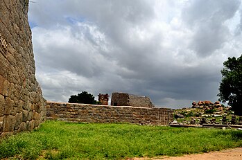
Hampi formed one of the core areas of the capital of the Vijayanagara Empire from 1343 to 1565, when it was finally laid siege to by the Deccan Muslim confederacy.[2] Hampi was chosen because of its strategic location, bounded by the torrential Tungabhadra river on one side and surrounded by defensible hills on the other three sides.
The site is significant historically and architecturally. The topography abounds with large stones which have been used to make statues of Jaina deities. The Archaeological Survey of India continues to conduct excavations in the area, to discover additional artifacts and temples.[8]
The Islamic Quarter, sometimes also called the Moorish Quarter, is located between the northern slope of the Malyavanta hill and the Talarigatta Gate. According to archaeologists, high-ranking Muslim officers of the king's court and military officers lived in this area.[9]
Geography
Hampi is situated on the banks of the Tungabhadra river. It is 353 km from Bangalore and 74 km away from Bellary. Hosapete (Hospet), 13 km away, is the nearest railway head. Mantralayam, which is also on the banks of Tunghabhadra, in AP is some 150 km away.The principal industries of the village are agriculture, the support of the Virupaksha temple and some other local holy places in the vicinity, as well as tourism. The annual Hampi Utsav or "Vijaya Festival" celebrated since Vijayanagara reign. It is organized by the Government of Karnataka as Nada Festival.[10]
Due to the presence of several mineral deposits in this region (iron-ore, manganese), mining has been done for a number of years. A recent boom for the supply of iron-ore in the international market has led to increased levels of mining in this district. Some feel that the World Heritage Site at Hampi as well as the Tungabhadra Dam is under threat as a result.
Architecture
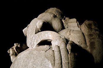
The city of Vijayanagara was originally encompassed by seven lines of fortifications. These fortifications had a large number of bastions and gateways. The seventh & the innermost fortification enclosed the main city & is the best preserved.[11] The extant monuments of Vijayanagara or Hampi can be divided into Religious, Civil & Military buildings. While most of the monuments at Hampi are from the Vijayanagara period, a small proportion may be assigned to pre-Vijayanagara times. The Jain temples on Hemakuta hill, the two Devi shrines & some other structures in the Virupaksha temple complex predate the Vijanagara empire. The earliest amongst them, the Shaiva shrines with their stepped pyramidal vimanas or superstructures, date to the early Chalukyan period around ninth-tenth century AD.[12]
Religious buildings
Hampi has various notable Hindu temples with some vedanta mythology inside the temples, some of which are still active places of worship. Among the most notable are:
- Achyutaraya Temple
- Badavi Linga
- Chandramauleshwara Temple
- Malyavanta Raghunathaswamy temple was constructed in the ancient style of architecture, the temple of Malyavanta Raghunathaswamy stands 3 km down the road. Its inner walls flaunt peculiar and interesting motifs of fish and marine creatures.[13]
- Hazara Rama Temple Complex: This ruined temple complex is well known for elaborate frescoes from the Hindu religion and a sprawling courtyard well-laid with gardens. It is well known for more than many thousand carvings & inscriptions on & in the temple depicting the mighty story of Ramayana. It has about 1000 carvings & inscriptions depicting the story of Ramayana.[14]

- Hemakuta group of temples
- Krishna Temple Complex: This temple complex has been recently excavated through the last decade, and restoration work is still in progress. The temple has the Sacred Tank or the Pushkarani located on its eastern side.


- Vittala Temple Complex:This is perhaps the most famous and well-known among the ruins of Hampi. The iconic stone chariot in the vicinity of this temple complex is a symbol of Karnataka Tourism. Of late, floodlights have been installed in the temple complex that provide illumination at dusk, thereby adding to the grandeur of the architecture.
The temple houses the famous musical pillars. The British wanted to check the reason behind this wonder and so they had cut two pillars to check if anything was there inside the pillars that was producing the sound. They had found nothing but hollow pillars. Even today we can see those pillars cut by the British.
The road leading to the temple was once a market where the horses were traded. Even today we can see the ruins of the market on both the sides of the road. The temple contains the images of foreigners like Persians selling horses.
- Muslim Sunni masjid
- Preksha temple and groups
- Saasivekaalu Ganesha
- Virupaksha Temple known as the Pampavathi temple, it is an ancient temple situated in the Hampi Bazaar. It predates the founding of the Vijayanagara empire. The temple has a 160-foot (49 m) high tower at its entrance. Apart from Shiva, the temple complex also contains shrines of the erotica statues Bhuvaneshwari and Pampa.
- Underground Shiva Temple
- Yantrodharaka Anjaneya temple
Civil buildings
- Aqueducts and Canals

The remains of a giant Bukka's Aqueduct located near Anegondi - Archaeological Museum at Kamalapura
- Lotus Mahal

Lotus Mahal at the Zenana Enclosure - Zanana enclosure


Military buildings
- Elephant stables:used to house the eleven royal elephants in King Krishnadeva Raya's army. The neighbouring building housed the elephant riders of the royal elephants.
- The Kings’ balance

Important sites at and near Hampi
- Anegondi
- Anjeyanadri Hill
- Kadalekalu Ganesha
- Lake (Near Sanapur)
- Tungabhadra River
- Uddana Veerabhadra temple
- Sri Lakshmi Narasimha
- Virupapura
- Yeduru Basavanna
- Talarigatta Gate
- Bhim'a Gate
- Tenali Rama Pavilion
Global Heritage Fund efforts
Non-profit organization Global Heritage Fund (GHF), in partnership with the Hampi Foundation, Cornell University, and the State of Karnataka, has been actively involved in the conservation of Hampi's unique cultural heritage. After producing a master conservation plan for the site of Chandramouleshwara Temple, GHF's efforts have moved to "stabilization of the temple and its associated structural features."[15]
Scenery

Hampi Gallery
-
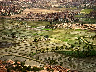 Farms as seen from Anjaneyadri Hill
 -
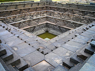 Stepped Tank near the Underground Temple
 -
 Stray Temples
 -
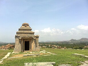
 Watch Tower
 -
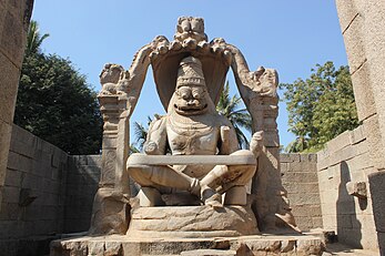 Narasimha Vigraha
 -
 Zanana Enclosure
 -
 Stone Monolithic Nandi Bull statue - carved out of a single boulder at the Main Market
 -
 Tungabhadra River in Hampi
 -
 Tall Carved pillars of the Saasivekaalu Ganesha Temple at Hemakuta Hill
 -
 Monolithic Ganesha at the Hemakuta Hill, Hampi Bazaar
 -
 Sunset in Hampi, Karnataka.


See also
- Anegundi
- Bukka
- Kanakagiri
- Krishna Deva Raya
- Vidyaranya
- Vijayanagara Empire
- Vijayanagara Architecture
Notes
- ^ "Hampi Village Population - Hospet - Bellary, Karnataka". Census2011.co.in. Retrieved 2015-08-11.
- ^ a b "Group of Monuments at Hampi". World Heritage. Retrieved 2006-12-20.
- ^ "Hampi most searched historical place in Karnataka on Google". economictimes.indiatimes.com. Retrieved 2014-08-26.
- ^ "From the ruins of Hampi to the uninhabited Ross Islands: 11 abandoned places in India that were once heavily populated settlements". IBNLive. 2014-09-03. Retrieved 2015-08-11.
- ^ D Devakunjari. World Heritage Series: HAMPI. Eicher Goodearth Limited, New Delhi for Archaeological Survey of India. p. 08. ISBN 81-87780-42-8.
- ^ a b D Devakunjari (2007). World Heritage Series HAMPI. Eicher Goodearth Limited, New Delhi for Archaeological Survey of India. p. 11. ISBN 8187780428.
- ^ "Less Known Facts about Hampi | Sightseeing | Hampi". Karnataka.com. 2015-01-09. Retrieved 2015-08-11.
- ^ "Group of Monuments at Hampi, Karnataka - Archaeological Survey of India". Asi.nic.in. Retrieved 2015-08-11.
- ^ Zones of Hampi
- ^ "Hampi Utsav | Hampi Festival | Vurupaksha Temple". Karnataka.com. 2015-01-09. Retrieved 2015-08-11.
- ^ D Devakunjari (2007). World Heritage Series HAMPI. Eicher Goodearth Limited, New Delhi for Archaeological Survey of India. p. 32. ISBN 8187780428.
- ^ D Devakunjari (2007). World Heritage Series HAMPI. Eicher Goodearth Limited, New Delhi for Archaeological Survey of India. pp. 22, 23. ISBN 8187780428.
- ^ "Shimla, Himachal Pradesh – Expert Bulletin". Expertbulletin.com. Retrieved 2013-10-05.
- ^ Gopal, Madan (1990). K.S. Gautam (ed.). India through the ages. Publication Division, Ministry of Information and Broadcasting, Government of India. p. 178.
- ^ Global Heritage Fund - Where We Work - Hampi, India Accessed on 2009-04-24.
9. http://www.incrediblehampi.org/
References
- S.Srinivasachar, T.S.Satyan, 'Hampi : The fabled capital of the Vijayanagara Empire, (Directorate of Archaeology and Museums), Govt. of Karnataka, 1995
- J.M. Fritz et al., New Light on Hampi: Recent Research at Vijayanagara, (Performing Arts Mumbai, 2001) ISBN 81-85026-53-X
- A.N. Longhurst, Hampi Ruins Described and Illustrated, (Laurier Books Ltd., 1998) ISBN 81-206-0159-9
- The Ruins of Hampi:Travel Guide ISBN 81-7525-766-0
- Karnataka State Gazetteer 1983.
External links
- [1]
- Archaeological Survey of India Museum Hampi
- Group of Monuments at Hampi - UNESCO World Heritage List
- www.HAMPI.in
- Hampi Online
- Hampi: Tenali's Wonderful Town
- Hampi, “A Forgotten Empire”
- Hampi. Kala Darshana
- Hampi in the News. The Times of India September 2012. Global Heritage Fund
- Explore Hampi with Google Earth. Global Heritage Fund
- Hampi @ Karnataka.com
- http://www.malligihotels.com/monuments.html
- Hampi Photographs, 2013
- Elephant Stables Photographs, 2013
- 360 degree spherical panoramas of the Monkey temple
- Landscapes of Hampi (Video)
| Andhra Pradesh |
|  |
|---|---|---|
| Arunachal Pradesh | ||
| Assam | ||
| Bihar | ||
| Chhattisgarh | ||
| Goa | ||
| Gujarat | ||
| Haryana | ||
| Himachal Pradesh | ||
| Jammu and Kashmir | ||
| Jharkhand | ||
| Karnataka | ||
| Kerala | ||
| Madhya Pradesh | ||
| Maharashtra | ||
| Odisha | ||
| Punjab | ||
| Sikkim | ||
| Tamil Nadu | ||
| Telangana | ||
| Tripura | ||
| Uttarakhand | ||
| Uttar Pradesh | ||
| West Bengal | ||
| International | |
|---|---|
| Other | |