Lagawe: Difference between revisions
Appearance
Content deleted Content added
No edit summary |
Rescuing 1 sources and tagging 0 as dead. #IABot (v1.3) |
||
| Line 115: | Line 115: | ||
*[http://www.batch2006.com/visit_lagawe.htm More photos and information on Lagawe, Ifugao] |
*[http://www.batch2006.com/visit_lagawe.htm More photos and information on Lagawe, Ifugao] |
||
*[http://nap.psa.gov.ph/activestats/psgc/default.asp Philippine Standard Geographic Code] |
*[http://nap.psa.gov.ph/activestats/psgc/default.asp Philippine Standard Geographic Code] |
||
*[ |
*[https://web.archive.org/web/20131004104825/http://census.gov.ph/ Philippine Census Information] |
||
*[http://www.blgs.gov.ph/lgpmsv2/cmshome/index.php?pageID=23&frmIdDcfCode=7&fLguType=CM&frmIdRegion=17&frmIdProvince=90&frmIdLgu=170 Local Governance Performance Management System] |
*[http://www.blgs.gov.ph/lgpmsv2/cmshome/index.php?pageID=23&frmIdDcfCode=7&fLguType=CM&frmIdRegion=17&frmIdProvince=90&frmIdLgu=170 Local Governance Performance Management System] |
||
Revision as of 13:35, 10 May 2017
Lagawe | |
|---|---|
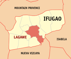
 Map of Ifugao with Lagawe highlighted | |
| Country | |
| Region | Cordillera Administrative Region |
| Province | Ifugao |
| District | Lone District of Ifugao |
| Barangays | 20 (see Barangays) |
| Government | |
| • Type | Sangguniang Bayan |
| • mayor of Lagawe[*] | Ceasario D. Cabbigat |
| • Electorate | 13,064 voters (2022) |
| Area | |
| • Total | 208.91 km2 (80.66 sq mi) |
| Population (2020 census)[3] | |
| • Total | 18,876 |
| • Density | 90/km2 (230/sq mi) |
| Time zone | UTC+8 (PST) |
| ZIP code | 3600 |
| PSGC | |
| IDD : area code | +63 (0)74 |
| Income class | 4th municipal income class |
| Revenue (₱) | ₱ 126.4 million (2020) |
| Website | www |
Lagawe (Template:Lang-ilo), officially the Municipality of Lagawe is a 4th class municipality in the province of Ifugao, Philippines. According to the 2020 census, it has a population of 18,876 people.[3]. It is the capital of Ifugao.
Barangays
Lagawe is politically subdivided into 20 barangays. [2]
- Abinuan
- Banga
- Boliwong
- Burnay
- Buyabuyan
- Caba
- Cudog
- Dulao
- Jucbong
- Luta
- Montabiong
- Olilicon
- Poblacion South
- Poblacion East
- Poblacion North
- Poblacion West
- Ponghal
- Pullaan
- Tungngod
- Tupaya
Demographics
| Year | Pop. | ±% p.a. |
|---|---|---|
| 1990 | 12,437 | — |
| 1995 | 14,898 | +3.44% |
| 2000 | 15,269 | +0.53% |
| 2007 | 17,477 | +1.88% |
| 2010 | 18,077 | +1.24% |
| 2015 | 19,333 | +1.29% |
| Source: Philippine Statistics Authority[4][5] | ||
In the 2020 census, the population of Lagawe, Ifugao, was 18,876 people,[3] with a density of 90 inhabitants per square kilometre or 230 inhabitants per square mile.
References
- ^ Municipality of Lagawe | (DILG)
- ^ a b "Province: Ifugao". PSGC Interactive. Quezon City, Philippines: Philippine Statistics Authority. Retrieved 12 November 2016.
- ^ a b c Census of Population (2020). "Cordillera Administrative Region (CAR)". Total Population by Province, City, Municipality and Barangay. Philippine Statistics Authority. Retrieved 8 July 2021.
- ^ Census of Population (2015). "Cordillera Administrative Region (CAR)". Total Population by Province, City, Municipality and Barangay. Philippine Statistics Authority. Retrieved 20 June 2016.
- ^ Census of Population and Housing (2010). "Cordillera Administrative Region (CAR)" (PDF). Total Population by Province, City, Municipality and Barangay. National Statistics Office. Retrieved 29 June 2016.
External links
Wikimedia Commons has media related to Lagawe.
- More photos and information on Lagawe, Ifugao
- Philippine Standard Geographic Code
- Philippine Census Information
- Local Governance Performance Management System

