
Bellville, Texas
Bellville, Texas | |
|---|---|
 Stores along Holland Street on the courthouse square | |
| Motto: "A Texas Experience" | |
 Location of Bellville, Texas | |
| Country | United States |
| State | Texas |
| County | Austin |
| Area | |
| • Total | 2.7 sq mi (6.9 km2) |
| • Land | 2.7 sq mi (6.9 km2) |
| • Water | 0.0 sq mi (0.0 km2) |
| Elevation | 292 ft (89 m) |
| Population (2010) | |
| • Total | 4,097 |
| • Density | 1,543/sq mi (595.6/km2) |
| Time zone | UTC-6 (Central (CST)) |
| • Summer (DST) | UTC-5 (CDT) |
| ZIP code | 77418 |
| Area code | 979 |
| FIPS code | 48-07432[1] |
| GNIS feature ID | 1372492[2] |
| Website | www |
Bellville is a city in the U.S. state of Texas and the seat of Austin County. The city's population was 4,097 at the 2010 census.[3] Bellville was named for Thomas B. Bell, one of Stephen F. Austin's earliest colonists, after he and his brother James Bell donated land for the new county seat established by voters in 1846. The original county seat was located in San Felipe. Bellville is located at the intersection of State Highway 36 and State Highway 159 as well as FM 529, FM 1456, and FM 2429.
Geography
Bellville is located in southern Austin County at 29°56′50″N 96°15′31″W / 29.94722°N 96.25861°W (29.947225, -96.258657).[4] Sealy, along Interstate 10, is 10 miles (16 km) to the south, Hempstead is 15 miles (24 km) to the northeast, and Brenham is 18 miles (29 km) to the northwest. Downtown Houston is 64 miles (103 km) to the southeast via Sealy and Interstate 10.
According to the United States Census Bureau, Bellville has a total area of 2.7 square miles (6.9 km2), all of it land.[3]
Demographics
| Census | Pop. | Note | %± |
|---|---|---|---|
| 1880 | 500 | — | |
| 1890 | 807 | 61.4% | |
| 1930 | 1,533 | — | |
| 1940 | 1,347 | −12.1% | |
| 1950 | 2,112 | 56.8% | |
| 1960 | 2,218 | 5.0% | |
| 1970 | 2,371 | 6.9% | |
| 1980 | 2,860 | 20.6% | |
| 1990 | 3,378 | 18.1% | |
| 2000 | 3,794 | 12.3% | |
| 2010 | 4,097 | 8.0% | |
| 2015 (est.) | 4,262 | [5] | 4.0% |
As of the census[1] of 2000, there were 3,794 people, 1,425 households, and 966 families residing in the city. The population density was 1,452.0 people per square mile (561.3/km²). There were 1,566 housing units at an average density of 599.3 per square mile (231.7/km²). The racial makeup of the city was 81.89% White, 11.68% African American, 0.40% Native American, 0.34% Asian, 3.95% from other races, and 1.74% from two or more races. Hispanic or Latino of any race were 11.97% of the population.
There were 1,425 households out of which 34.7% had children under the age of 18 living with them, 52.6% were married couples living together, 11.6% had a female householder with no husband present, and 32.2% were non-families. 27.9% of all households were made up of individuals and 15.3% had someone living alone who was 65 years of age or older. The average household size was 2.52 and the average family size was 3.11.
In the city the population was spread out with 26.4% under the age of 18, 8.3% from 18 to 24, 25.3% from 25 to 44, 20.2% from 45 to 64, and 19.7% who were 65 years of age or older. The median age was 38 years. For every 100 females there were 90.9 males. For every 100 females age 18 and over, there were 85.1 males.
The median income for a household in the city was $40,806, and the median income for a family was $49,730. Males had a median income of $36,719 versus $21,685 for females. The per capita income for the city was $17,671. About 4.5% of families and 8.0% of the population were below the poverty line, including 7.9% of those under age 18 and 8.1% of those age 65 or over.
Education
Bellville Independent School District serves Bellville.
Schools
- Bellville High School (Grades 9-12)
- Bellville Junior High School (Grades 6-8)
- O'Bryant Intermediate School (4-5)
- O'Bryant Primary School (PK-3)
- West End Elementary School (K-5)
- Faith Academy of Bellville (PK-12)
Climate
The climate in this area is characterized by relatively high temperatures and evenly distributed precipitation throughout the year. The Köppen Climate System describes the weather as humid subtropical, and uses the abbreviation Cfa.[7]
Notable residents
- Beau Bell, Major League Baseball player
- William Crump, first Speaker of the Texas House of Representatives following statehood
- Johnny Holland, NFL linebacker and coach
- Ernie Koy, Major League Baseball player
- Ernie Koy, Jr., NFL player
- Ted Koy, NFL player
- Emmanuel Sanders, NFL wide receiver
- David Smith, reality television show contestant
- Doug Supernaw, country music artist
- Kelly Kaminski, world champion barrel racer[8]
Gallery
-
 Historic old jail and museum in Bellville
 -
 State historical marker at the old jail
 -
 City Hall building on Holland and Luhn Streets
 -
 Historical marker in front of City Hall
 -
 Bellville public library at Holland and Palm Streets
 -
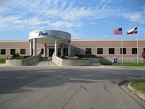 Bellville St. Joseph Health Center on Palm Street
 -
 St. Mary's Episcopal Church on Main Street


References
- ^ a b "American FactFinder". United States Census Bureau. Archived from the original on 2013-09-11. Retrieved 2008-01-31.
{{cite web}}: Unknown parameter|deadurl=ignored (|url-status=suggested) (help) - ^ "US Board on Geographic Names". United States Geological Survey. 2007-10-25. Retrieved 2008-01-31.
- ^ a b "Geographic Identifiers: 2010 Demographic Profile Data (G001): Bellville city, Texas". U.S. Census Bureau, American Factfinder. Retrieved August 26, 2013.
- ^ "US Gazetteer files: 2010, 2000, and 1990". United States Census Bureau. 2011-02-12. Retrieved 2011-04-23.
- ^ "Annual Estimates of the Resident Population for Incorporated Places: April 1, 2010 to July 1, 2015". Retrieved July 2, 2016.
- ^ "Census of Population and Housing". Census.gov. Archived from the original on May 11, 2015. Retrieved June 4, 2015.
{{cite web}}: Unknown parameter|deadurl=ignored (|url-status=suggested) (help) - ^ Climate Summary for Bellville, Texas
- ^ "Kelly Kaminski". About.com Rodeo. Retrieved 2014-02-09.
{{cite web}}: Cite has empty unknown parameter:|1=(help)
External links
Municipalities and communities of Austin County, Texas, United States | ||
|---|---|---|
| Cities |  | |
| Towns | ||
| Other communities | ||
| Ghost town | ||
| Footnotes | ‡This populated place also has portions in an adjacent county or counties | |