Jacksonville is in the First Coast region of northeast Florida and is centered on the banks of the St. Johns River, about 25 miles (40 km) south of the Georgia state line and about 340 miles (550 km) north of Miami. The Jacksonville Beaches communities are along the adjacent Atlantic coast. The area was originally inhabited by the Timucua people, and in 1564 was the site of the French colony of Fort Caroline, one of the earliest European settlements in what is now the continental United States. Under British rule, settlement grew at the narrow point in the river where cattle crossed, known as Wacca Pilatka to the Seminole and Cowford to the British. A platted town was established there in 1822, a year after the United States gained Florida from Spain; it was named after Andrew Jackson, the first military governor of the Florida Territory and seventh President of the United States.
Harbor improvements since the late 19th century have made Jacksonville a major military and civilian deep-water port. Its riverine location facilitates two U.S. Navy bases and the Port of Jacksonville, Florida's third largest seaport.[5] Significant factors in the local economy include services such as banking, insurance, healthcare and logistics. As with much of Florida, tourism is also important to the Jacksonville area, particularly tourism related to golf.[6][7] In 2010, Jacksonville was listed as a "high sufficiency" world city in the World Cities Study Group’s inventory, ranking alongside cities such as Liverpool and Las Vegas.[8] People from Jacksonville are known as "Jacksonvillians" or "Jaxons".[9]
The area of the modern city of Jacksonville has been inhabited for thousands of years. On Black Hammock Island in the national Timucuan Ecological and Historic Preserve, a University of North Florida team discovered some of the oldest remnants of pottery in the United States, dating to 2500 BC.[10] In the 16th century, the beginning of the historical era, the region was inhabited by the Mocama, a coastal subgroup of the Timucua people. At the time of contact with Europeans, all Mocama villages in present-day Jacksonville were part of the powerful chiefdom known as the Saturiwa, centered around the mouth of the St. Johns River.[11] One early map shows a village called Ossachite at the site of what is now downtown Jacksonville; this may be the earliest recorded name for that area.[12]
European explorers first arrived in the area 1562, when FrenchHuguenot explorer Jean Ribault charted the St. Johns River. In 1564, René Goulaine de Laudonnière established the first European settlement, Fort Caroline, on the St. Johns near the main village of the Saturiwa. On September 20, 1565, a Spanish force from the nearby Spanish settlement of St. Augustine attacked Fort Caroline, and killed nearly all the French soldiers defending it.[13] The Spanish renamed the fort San Mateo, and following the ejection of the French, St. Augustine's position as the most important settlement in Florida was solidified.
Spain ceded Florida to the British in 1763 after the French and Indian War, and the British soon constructed the King's Road connecting St. Augustine to Georgia. The road crossed the St. Johns River at a narrow point, which the Seminole called Wacca Pilatka and the British named the "Cow Ford", both names ostensibly reflecting the fact that cattle were brought across the river there.[14][15][16] Britain ceded control of the territory back to Spain in 1783, after its defeat in the American Revolutionary War, and the settlement at the Cow Ford continued to grow. After Spain ceded the Florida Territory to the United States in 1821, American settlers on the north side of the Cow Ford decided to plan a town, laying out the streets and plats. They soon named the town "Jacksonville," after Andrew Jackson. Led by Isaiah D. Hart, residents wrote a charter for a town government, which was approved by the Florida Legislative Council on February 9, 1832.
During the American Civil War, Jacksonville was a key supply point for hogs and cattle being shipped from Florida to aid the Confederate cause. The city was blockaded by Union forces, who gained control of the nearby Fort Clinch. From 1862, they controlled the city and most of the First Coast for the duration of the war. Though no battles were fought in Jacksonville proper, the city changed hands several times between Union and Confederate forces. Warfare and the long occupation left the city disrupted after the war.
During Reconstruction and the Gilded Age, Jacksonville and nearby St. Augustine became popular winter resorts for the rich and famous. Visitors arrived by steamboat and later by railroad. President Grover Cleveland attended the Sub-Tropical Exposition in the city on February 22, 1888 during his trip to Florida.[17] This highlighted the visibility of the state as a worthy place for tourism. The city's tourism, however, was dealt major blows in the late 19th century by yellow fever outbreaks. In addition, extension of the Florida East Coast Railway further south drew visitors to other areas. From 1893 to 1938 Jacksonville was the site of the Florida Old Confederate Soldiers and Sailors Home with a nearby cemetery.[18]
On May 3, 1901, downtown Jacksonville was ravaged by a fire that started at a fiber factory. Known as the "Great Fire of 1901", it was one of the worst disasters in Florida history and the largest urban fire in the southeastern United States. In just eight hours, it destroyed the business district and left approximately 10,000 residents homeless. It is said the glow from the flames could be seen in Savannah, Georgia, and the smoke plumes seen in Raleigh, North Carolina. Architect Henry John Klutho was a primary figure in the reconstruction of the city. More than 13,000 buildings were constructed between 1901 and 1912.
A view of Jacksonville in 1909
In the 1910s, New York–based filmmakers were attracted to Jacksonville's warm climate, exotic locations, excellent rail access, and cheap labor. Over the course of the decade, more than 30 silent filmstudios were established, earning Jacksonville the title of "Winter Film Capital of the World". However, the emergence of Hollywood as a major film production center ended the city's film industry. One converted movie studio site, Norman Studios, remains in Arlington; It has been converted to the Jacksonville Silent Film Museum at Norman Studios.[19]
During this time, Jacksonville also became a banking and insurance center, with companies such as Barnett Bank, Atlantic National Bank, Florida National Bank, Prudential, Gulf Life, Afro-American Insurance, Independent Life and American Heritage Life thriving in the business district. The U.S. Navy also became a major employer and economic force during the 1940s, with the construction of three naval bases in the city.
Jacksonville, like most large cities in the United States, suffered from negative effects of rapid urban sprawl after World War II. The construction of highways led residents to move to newer housing in the suburbs. After World War II, the government of the city of Jacksonville began to increase spending to fund new public building projects in the boom that occurred after the war. Mayor W. Haydon Burns' Jacksonville Story resulted in the construction of a new city hall, civic auditorium, public library and other projects that created a dynamic sense of civic pride. However, the development of suburbs and a subsequent wave of middle class "white flight" left Jacksonville with a much poorer population than before. The city's most populous ethnic group, non-Hispanic white,[20] declined from 75.8% in 1970 to 55.1% by 2010.[21]
Much of the city's tax base dissipated, leading to problems with funding education, sanitation, and traffic control within the city limits. In addition, residents in unincorporated suburbs had difficulty obtaining municipal services, such as sewage and building code enforcement. In 1958, a study recommended that the city of Jacksonville begin annexing outlying communities in order to create the needed tax base to improve services throughout the county. Voters outside the city limits rejected annexation plans in six referendums between 1960 and 1965.
In the mid-1960s, corruption scandals began to arise among many of the city's officials, who were mainly elected through the traditional old boy network. After a grand jury was convened to investigate, 11 officials were indicted and more were forced to resign. Jacksonville Consolidation, led by J. J. Daniel and Claude Yates, began to win more support during this period, from both inner city blacks, who wanted more involvement in government, and whites in the suburbs, who wanted more services and more control over the central city. In 1964 all 15 of Duval County's public high schools lost their accreditation. This added momentum to proposals for government reform. Lower taxes, increased economic development, unification of the community, better public spending and effective administration by a more central authority were all cited as reasons for a new consolidated government.
When a consolidation referendum was held in 1967, voters approved the plan. On October 1, 1968, the governments merged to create the Consolidated City of Jacksonville. Fire, police, health & welfare, recreation, public works, and housing & urban development were all combined under the new government. In honor of the occasion, then-Mayor Hans Tanzler posed with actress Lee Meredith behind a sign marking the new border of the "Bold New City of the South" at Florida 13 and Julington Creek.[22]
The Better Jacksonville Plan, promoted as a blueprint for Jacksonville's future and approved by Jacksonville voters in 2000, authorized a half-penny sales tax. This would generate most of the revenue required for the $2.25 billion package of major projects that included road & infrastructure improvements, environmental preservation, targeted economic development and new or improved public facilities.[23]
A simulated-color image of Jacksonville, taken on NASA's Landsat 7 satellite.
According to the United States Census Bureau, the city has a total area of 874.3 square miles (2,264 km2), making Jacksonville the largest city in land area in the contiguous United States; of this, 86.66% (757.7 sq mi or 1,962 km2) is land and ; 13.34% (116.7 sq mi or 302 km2) is water. Jacksonville completely encircles the town of Baldwin. Nassau County lies to the north, Baker County lies to the west, and Clay and St. Johns County lie to the south; the Atlantic Ocean lies to the east, along with the Jacksonville Beaches. The St. Johns River divides the city. The Trout River, a major tributary of the St. Johns River, is located entirely within Jacksonville.
The state of Florida, including Jacksonville, is a huge flat plateau with a high water table, and surface lakes are very shallow.[24]
The United States Geological Survey states that the highest point in Jacksonville is only 40 feet (12.2 meters) above sea level, making the area susceptible to flooding and storm surge.[25]
Soil composition is primarily sand and clay rather than limestone, so very few sinkholes develop; however deep, large diameter sinkholes do occur.[26]
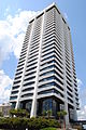
The tallest building in Downtown Jacksonville's skyline is the Bank of America Tower, constructed in 1990 as the Barnett Center. It has a height of 617 ft (188 m) and includes 42 floors.[32][33] Other notable structures include the 37-story Wells Fargo Center (with its distinctive flared base making it the defining building in the Jacksonville skyline),[34][35] originally built in 1972-74 by the Independent Life and Accident Insurance Company, and the 28 floor Riverplace Tower which, when completed in 1967, was the tallest precast, post-tensioned concrete structure in the world.[36][37]
Jacksonville is interesting from an architectural view with fourteen buildings on the document, "Florida Architecture: 100 places, 100 years", compiled by the Florida chapter of the American Institute of Architects.[38]
Jacksonville has a humid subtropical climate (Köppen Cfa), with mild weather during winters and hot weather during summers. High temperatures average 64 to 92 °F (18 to 33 °C) throughout the year.[39] High heat indices are not uncommon for the summer months in the area, with indices above 110 °F (43.3 °C) possible. The highest temperature recorded in was 104 °F (40 °C) on July 11, 1879 and July 28, 1872.[40] It is common for thunderstorms to erupt during a typical summer afternoon. These are caused by the rapid heating of the land relative to the water, combined with extremely high humidity.
During winter, there can be hard freezes during the night. Such cold weather is usually short lived, as the city averages only 10 to 15 nights at or below freezing and around 5 days where the high does not rise above 50 °F (10 °C).[41] The coldest temperature recorded at Jacksonville International Airport was 7 °F (−14 °C) on January 21, 1985, which continues to hold the lowest temperature on record for many locations in the southeastern U.S. Even rarer in Jacksonville than freezing temperatures is snow. When snow does fall, it usually melts upon making contact with the ground. Most residents of Jacksonville can remember accumulated snow on only two occasions—-the first was a thin ground cover that occurred December 23, 1989.[42] The second event happened on December 26, 2010, when measurable snow fell for the first time in 21 years across metropolitan Jacksonville. Occurring in the morning, it also marked the first time since 1989 that the official National Weather Service recording equipment at Jacksonville International picked up frozen precipitation.[43]
Hurricane Dora as seen on Daytona Beach WSR-57 radar in September 1964.
Jacksonville has suffered less damage from hurricanes than most other east coast cities, although the threat does exist for a direct hit by a major hurricane. The city has only received one direct hit from a hurricane since 1871; however, Jacksonville has experienced hurricane or near-hurricane conditions more than a dozen times due to storms crossing the state from the Gulf of Mexico to the Atlantic Ocean, or passing to the north or south in the Atlantic and brushing past the area.[44] The strongest effect on Jacksonville was from Hurricane Dora in 1964, the only recorded storm to hit the First Coast with sustained hurricane force winds. The eye crossed St. Augustine with winds that had just barely diminished to 110 mph (180 km/h), making it a strong Category 2 on the Saffir-Simpson Scale. Jacksonville also suffered damage from 2008's Tropical Storm Fay which crisscrossed the state, bringing parts of Jacksonville under darkness for four days. Similarly, four years prior to this, Jacksonville was inundated by Hurricane Frances and Hurricane Jeanne, which made landfall south of the area. These tropical cyclones were the costliest indirect hits to Jacksonville. Hurricane Floyd in 1999 caused damage mainly to Jacksonville Beach. During Floyd, the Jacksonville Beach pier was severely damaged, and later demolished. The rebuilt pier was later damaged by Fay, but not destroyed. Tropical Storm Bonnie would cause minor damage in 2004, spawning a minor tornado in the process.[45] On May 28, 2012, Jacksonville was hit by Tropical Storm Beryl, packing winds up to 70 miles per hour (113 km/h) which made landfall near Jacksonville Beach.
Rainfall averages around 52 inches (1,300 mm) a year, with the wettest months being June through September.[46]
Jacksonville is the most populous city in Florida, and the eleventh most populous city in the United States. As of 2010, there were 821,784 people and 366,273 households in the city. The largest ancestries include: German (9.6%), American (9.3%), Irish (9.0%), English (8.5%), and Italian (3.5%). Jacksonville has the country's tenth-largest Arab population, with a total population of 5,751 according to the 2000 United States Census.[49][50] Jacksonville has Florida's largest Filipino American community, with 25,033 in the metropolitan area as of the 2010 Census. Much of Jacksonville's Filipino community served in or has ties to the United States Navy.[51][52] Jacksonville also has a large and growing Puerto Rican population.
As of 2010, there were 366,273 households out of which 11.8% were vacant. As of 2000, 33.9% of households had children under the age of 18 living with them, 46.7% were married couples living together, 16.0% had a female householder with no husband present, and 33.0% were non-families. 26.2% of all households were made up of individuals and 7.7% had someone living alone who was 65 years of age or older. The average household size was 2.53 and the average family size was 3.07. In the city, the population was spread out with 26.7% under the age of 18, 9.7% from 18 to 24, 32.3% from 25 to 44, 21.0% from 45 to 64, and 10.3% who were 65 years of age or older. The median age was 34 years. For every 100 females there were 93.9 males. For every 100 females age 18 and over, there were 90.6 males.
In 2000, the median income for a household in the city was $40,316, and the median income for a family was $47,243. Males had a median income of $32,547 versus $25,886 for females. The per capita income for the city was $20,337. About 9.4% of families and 12.2% of the population were below the poverty line, including 16.7% of those under age 18 and 12.0% of those age 65 or over.
As of the 2006–2008 American Community Survey, 88.1% of Jacksonville's population age five and over spoke only English at home while 5.2% of the population spoke Spanish at home. About 3.2% spoke other Indo-European languages at home. About 2.5% spoke an Asian language at home. The remaining 0.9% of the population spoke other languages at home.[53]
There were also 7,734 members of the LDS Church (Mormons) and 404 Unitarian Universalists,[55] who have worshiped at the Unitarian Universalist Church of Jacksonville since 1906.[60] The Jewish community, which numbered 7,300 in 2000,[55] is largely centered in the neighborhood of Mandarin.[61] There are two Reform, two Conservative, and four Orthodox synagogues (three of them Chabad-affiliated), and two more synagogues in St. Augustine.[62] The Muslim community numbered 2,182 in 2000, and had three congregations, including the Islamic Center of Northeast Florida, the region's largest mosque.[55][63]
Jacksonville is a rail, air, and highway focal point and a busy port of entry, with Jacksonville International Airport, ship repair yards and extensive freight-handling facilities. Lumber, phosphate, paper, cigars and wood pulp are the principal exports; automobiles and coffee are among imports. The city's manufacturing base provides just 4.5% of local jobs, versus 8.5% nationally.[64]
According to Forbes in 2007, Jacksonville, Florida ranked 3rd in the top ten U.S. cities to relocate to find a job.[65] Jacksonville was also the 10th fastest growing city in the U.S.[66]
In 2008, Jacksonville had approximately 2.8 million visitors who stayed overnight, spending nearly $1 billion. Research Data Services of Tampa was commissioned to undertake the study, which quantified the importance of tourism. The total economic impact was $1.6 billion and supported nearly 43,000 jobs, 10% of the local workforce.[68]
Cecil Commerce Center is located on the site of the former Naval Air Station Cecil Field which closed in 1999 following the 1993 Base Realignment and Closure (BRAC) decision. Covering a total area of 22,939 acres (92.83 km2), it was the largest military base in the Jacksonville area. The parcel contains more than 3% of the total land area in Duval County (17,000 acres (69 km2)). The industrial and commercial-zoned center offers mid to large-size parcels for development and boasts excellent transportation and utility infrastructure as well as the third-longest runway in Florida.
To emphasize the city's transportation business and capabilities, the Jacksonville Regional Chamber of Commerce filed Jacksonville America's Logistics Center as a trademark on November 9, 2007. It was formally registered on August 4, 2009.[69] Cornerstone began promoting the city as "Jacksonville: America's Logistics Center" in 2009. Signs were added to the existing city limit markers on Interstate 95.[70]
Jacksonville is home to multiple military facilities, and with Naval Submarine Base Kings Bay nearby gives Jacksonville the third largest naval presence in the country.[71] Only Norfolk, Virginia and San Diego, California are bigger. The military is by far the largest employer in Jacksonville and its total economic impact is approximately $6.1 billion annually.[72]
Naval Air Station Jacksonville is a military airport located 4 miles (6.4 km) south of the central business district. Approximately 23,000 civilian and active-duty personnel are employed on the base. There are 35 operational units/squadrons assigned there and support facilities include an airfield for pilot training, a maintenance depot capable of virtually any task, from changing a tire to intricate micro-electronics or total engine disassembly. Also on-site is a Naval Hospital, a Fleet Industrial Supply Center, a Navy Family Service Center, and recreational facilities.
Naval Station Mayport is a Navy Ship Base that is the third largest fleet concentration area in the United States. Mayport's operational composition is unique, with a busy harbor capable of accommodating 34 ships and an 8,000-foot (2,400 m) runway capable of handling any aircraft used by the Department of Defense. Until 2007, it was home to the aircraft carrierUSS John F. Kennedy, which locals called "Big John". In January 2009, the Navy committed to stationing a nuclear-powered carrier at Mayport when the official Record of Decision was signed. The port will require approximately $500 million in facility enhancements to support the larger vessel, which will take several years to complete.[73] The carrier is projected to arrive in 2019, however an amphibious group is coming sooner.[74]
Blount Island Command is a Marine Corps Logistics Base whose mission is to support the Maritime Prepositioning Force (MPF) which provides for rapid deployment of personnel to link up with prepositioned equipment and supplies embarked aboard forward deployed Maritime Prepositioning Ships (MPS).
Coast Guard Sector Jacksonville is located on the St. Johns River next to Naval Station Mayport. Sector Jacksonville controls operations from Kings Bay, GA south to Cape Canaveral, FL. The CGC Kingfisher, CGC Maria Bray, and CGC Hammer are stationed at the Sector. Station Mayport is co-located with Sector Jacksonville and includes 25-foot (7.6 m) Response Boats, and 47-foot (14 m) Motor Life Boats.
The Port of Jacksonville, a seaport on the St. Johns River, is a large component of the local economy. Approximately 50,000 jobs in Northeast Florida are related to port activity and the port has an economic impact of $2.7 billion in Northeast Florida:[75]
The Florida Theatre, opened in 1927, is located in downtown Jacksonville and is one of only four remaining high-style movie palaces built in Florida during the Mediterranean Revival architectural boom of the 1920s.
Amity Turkish Cultural Center was established in 2006 as one of the major Dialogue and Cultural organizations in Jacksonville.
Theatre Jacksonville was organized in 1919 as the Little Theatre and is one of the oldest continually producing community theatres in the United States.
Sun-Ray Cinema, formerly the 5 Points Theatre and Riverside Theatre, opened in 1927. It was the first theater equipped to show talking pictures in Florida and the third nationally. It is located in the Five Points section of town and was renamed the Five Points Theater in 1949.[76][77]
The Ritz Theatre, opened in 1929, is located in the LaVilla neighborhood of the northern part of Jacksonville's downtown. The Jacksonville music scene was active in the 1930s in LaVilla, which was known as “Harlem of the South”.[78] Black musicians from across the country visited Jacksonville to play standing room only performances at the Ritz Theatre and the Knights of Pythias Hall. Cab Calloway, Duke Ellington, Ella Fitzgerald and Louis Armstrong were a few of the legendary performers who appeared. After his mother died when he was 15, Ray Charles lived with friends of his mother while he played piano at the Ritz for a year, before moving on to fame and fortune. The Ritz Theatre was rebuilt and opened in October 1999.
The Times-Union Center for the Performing Arts consists of three distinct halls: the Jim & Jan Moran Theater, a venue for touring Broadway shows; the Jacoby Symphony Hall, home of the Jacksonville Symphony Orchestra; and the Terry Theater, intended for small shows and recitals. The building was originally erected as the Civic Auditorium in 1962 and underwent a major renovation and construction in 1996.
The Jacksonville Veterans Memorial Arena, which opened in 2003, is a 16,000-seat performance venue that attracts national entertainment, sporting events and also houses the Jacksonville Sports Hall of Fame. It replaced the outdated Jacksonville Coliseum that was built in 1960 and demolished on June 26, 2003.
The Alhambra Dinner Theatre, located on the Southside near the University of North Florida, has offered professional productions that frequently starred well-known actors since 1967. There are also a number of popular community theatres such as Players by the Sea at Jacksonville Beach.
Atlantic Beach Experimental Theatre (ABET),[79] and Orange Park Community Theatre.[80]
In 1999, Stage Aurora Theatrical Company, Inc. was established in collaboration at Florida State College at Jacksonville (North Campus). Their goal is to produce theatre that enlightens, and it is the most popular theatre on the Northside, located at Gateway Town Center.[81]
Jacksonville native Pat Boone was a popular 1950s singer and teen idol. During the 1960s, the Classics IV was the most successful pop rock band from Jacksonville. Southern Rock was defined by the Allman Brothers Band, which formed in 1969 in Jacksonville. Lynyrd Skynyrd achieved near cult status and inspired Blackfoot, Molly Hatchet and .38 Special, all successful in the 1970s. The 1980s were a quiet decade for musical talent in Jacksonville.
A number of cultural events are also held in Jacksonville. The Jacksonville Jazz Festival, held downtown, is the second-largest jazz festival in the nation,[82] while Springing the Blues, one of the oldest and largest blues festivals, has been held in Jacksonville Beach since 1990.[83] The World of Nations Celebration has been held in Metropolitan Park since 1993, and features a number of events, food and souvenirs from various countries. The Jacksonville Film Festival, held at seven historic venues in the city, has been held since 2003 and has featured a variety of independent films, documentaries and shorts.
Throughout the year, many annual events of various types are held in Jacksonville. In sports, the annual Gate River Run has been held annually since March 1977.[84] It has been the US National 15-kilometre (9.3 mi) road race Championship since 1994 and is the largest race of its distance in the country with over 13,000 runners, spectators, and volunteers, making it Jacksonville's largest participation sporting event.[85] In college football, the Gator Bowl is held on January 1. It has been continuously held since 1946. Also, the Florida–Georgia game (also known as the "World's Largest Outdoor Cocktail Party"), the annual college football game between the rival Florida Gators and Georgia Bulldogs has been held in Jacksonville almost yearly since 1933. For six days in July the Jacksonville Kingfish Tournament is held for fishermen of all skills. With $500,000 of prizes up for grabs, up to 1000 boats participate with almost 30,000 spectators watching.
Other events include the Blessing of the Fleet held in March since 1985 and the Greater Jacksonville Agricultural Fair in November at the Jacksonville Fairgrounds and Exposition Center featuring games, rides, food, entertainment and livestock exhibition. Holiday celebrations include the Freedom, Fanfare & Fireworks celebration on July 4, the lighting of Jacksonville's official Christmas tree at the Jacksonville Landing on the day after Thanksgiving and the Jacksonville Light Parade of boats the following day.
The city center includes the Jacksonville Landing and the Jacksonville Riverwalks. The Landing is a popular riverfront dining and shopping venue, accessible by River Taxi from the Southbank Riverwalk. The Northbank Riverwalk runs 2.0 miles (3.2 km) along the St. Johns from Berkman Plaza to I-95 at the Fuller Warren Bridge while the Southbank Riverwalk stretches 1.2 miles (1.9 km) from the Radisson Hotel to Museum Circle. Adjacent to Museum Circle is St. Johns River Park, also known as Friendship Park. It is the location of Friendship Fountain, one of the most recognizable and popular attractions for locals as well as tourists in Jacksonville. This landmark was built in 1965 and promoted as the “World’s Tallest and Largest” fountain at the time.
The Cummer Museum of Art and Gardens is an art museum in Jacksonville's Riverside neighborhood. It was founded in 1961, following the death of Ninah Mae Holden Cummer, who willed her collection, home, and gardens to the museum. Its galleries display one of the world's three most comprehensive collections of Meissen porcelain as well as large collections of American, European, and Japanese art. The grounds also contain two acres of Italian and English gardens begun by Ninah Cummer.[86]
The Museum of Contemporary Art Jacksonville (MOCA Jacksonville) is a contemporary art museum funded and operated as a "cultural resource" of the University of North Florida. Tracing its roots back to the formation of Jacksonville's Fine Arts Society in 1924, it opened its current 60,000-square-foot (6,000 m2) facility next to the Main Library downtown in 2003. The museum features eclectic permanent and traveling exhibitions and a collection of over 700 works.[86]
The Jacksonville Maritime Museum, located in the Jacksonville Landing, includes models of ships, paintings, photographs and artifacts dating to 1562.[87]
Three other art galleries are located at educational institutions in town. Florida State College at Jacksonville has the Kent Gallery on their westside campus and the Wilson Center for the Arts at their main campus. The University Gallery is located on the campus of the University of North Florida.[90]
The Jacksonville Karpeles Manuscript Library Museum is a branch of the world's largest private collection of original manuscripts and documents. The museum in Jacksonville is in a 1921 neoclassical building on the outskirts of downtown.[91][92] In addition to document displays, there is also an antique-book library, with volumes dating from the late 19th century.
The Art Walk, a monthly outdoor art festival on the first Wednesday of each month, is sponsored by Downtown Vision, Inc, an organization which works to promote artistic talent and venues on the First Coast.
The Murray Hill Art Center was reopened in February of 2012 through a partnership of the City of Jacksonville Parks and Recreation Department (JaxParks) and the Art League of Jacksonville (a 501(c)(3) nonprofit dedicated to community arts education). The center is located at 4327 Kerle Street in the historic Murray Hill area on the westside of Jacksonville and offers community arts classes as well as shared studio space for aspiring artists. Visitors are welcomed year around for events and classes.
Adventure Landing is an amusement park with locations in Jacksonville and Jacksonville Beach. The Jacksonville Beach location contains Shipwreck Island, Duval County's only waterpark.
Jacksonville has two fully enclosed shopping malls. The oldest is the Regency Square Mall, which opened in 1967 and is located on former sand dunes in the Arlington area. The other is The Avenues Mall, which opened in 1990 on the Southside, at the intersection of I-95 and US 1. The Orange Park Mall is another mall located just south of the city in the suburb of Orange Park, Florida, in Clay County, off of Blanding Boulevard (State Road 21).
The end of the indoor shopping mall may be indicated by the opening of The St. Johns Town Center in 2005 and the River City Marketplace, on the Northside in 2006. Both of these are "open air" malls, with a similar mix of stores, but without being contained under a single, enclosed roof. According to the International Council of Shopping Centers (ICSC), only one enclosed mall has been built in the United States since 2006.[93]
Jacksonville operates the largest urban park system in the United States, providing facilities and services at more than 337 locations on more than 80,000 acres (320 km2) located throughout the city.[107] Jacksonville enjoys natural beauty from the St. Johns River and Atlantic Ocean. Many parks provide access for people to boat, swim, fish, sail, jetski, surf and waterski. Several parks around the city have received international recognition.
Hemming Plaza is Jacksonville's first and oldest park. It is downtown and surrounded by government buildings. Riverside Park and Memorial Park are the city's second and third oldest parks (respectively), and located in the historic Riverside area.
Tree Hill Nature Center is a nature preserve and environmental education center located five minutes from Downtown Jacksonville.
The Jacksonville Arboretum & Gardens broke ground on a new center in April, 2007 and held their grand opening on November 15, 2008.
The Veterans Memorial Wall is a tribute to local servicemen and women killed while serving in US armed forces. A ceremony is held each Memorial Day recognizing any service woman or man from Jacksonville who died in the previous year.
The Treaty Oak is a massive, 250 year-old tree at Jessie Ball DuPont Park in downtown. Office workers from nearby buildings sit on benches to eat lunch or read a book in the shade of its canopy.
The Friendship Fountain has been one of Jacksonville's most recognizable and popular attractions, it features a light show and music each evening.
The Jacksonville-Baldwin Rail Trail is a linear city park which runs 14.5 miles (23.3 km) from Imeson Road to a point past Baldwin, Florida.
The most noteworthy feature of Jacksonville government is its consolidated nature. The Duval County-Jacksonville consolidation eliminated any type of separate county executive or legislature, and supplanted these positions with the Mayor of Jacksonville and the City Council of the City of Jacksonville, respectively. Because of this, voters who live outside of the city limits of Jacksonville but inside Duval County are allowed to vote in elections for these positions and to run for them. In fact, in 1995, John Delaney, a resident of Neptune Beach, was elected mayor of the city of Jacksonville.
Jacksonville uses the Mayor-Council form of city government, also called the Strong-Mayor form, in which a mayor serves as the city's Chief Executive and Administrative officer. The mayor holds veto power over all resolutions and ordinances made by the city council and also has the power to hire and fire the head of various city departments. The current mayor is Alvin Brown, who assumed office on July 1, 2011.[108][109]
Jacksonville and Duval County historically maintained separate police agencies: the Jacksonville Police Department and Duval County Sheriff's Office. As part of consolidation in 1968, the two merged, creating the Jacksonville Sheriff's Office (JSO). The JSO is headed by the elected Sheriff of Jacksonville, currently John Rutherford, and is responsible for law enforcement and corrections in the county.
In 2010, Duval County's crime rate was 5,106 per 100,000 people, according to the Florida Department of Law Enforcement. The county's murder rate had been the highest among Florida's counties with a population of 500,000 or more for eleven years in 2009, leading to widespread discussion in the community about how to deal with the problem. In 2010 Duval County's violent crime rate decreased by 9.3% from the previous year, with total crime decreasing 7.3%, putting the murder rate behind that of Miami-Dade County.[110]
Some government services remained — as they had been before consolidation – independent of both city and county authority. In accordance with Florida law, the school board continues to exist with nearly complete autonomy. Jacksonville also has several quasi-independent government agencies which only nominally answer to the consolidated authority, including electric authority, port authority, transportation authority, housing authority and airport authority. The main environmental and agricultural body is the Duval County Soil and Water Conservation District, which works closely with other area and state agencies.
The Jacksonville Public Library had its beginnings when May Moore and Florence Murphy started the "Jacksonville Library and Literary Association" in 1878. The Association was populated by various prominent Jacksonville residents and sought to create a free public library and reading room for the city.[118]
Over the course of 127 years, the system has grown from that one room library to become one of the largest in the state. The Jacksonville library system has twenty branches, ranging in size from the 54,000 sq ft (5,000 m2) West Regional Library to smaller neighborhood libraries like Westbrook and Eastside. The Library annually receives nearly 4 million visitors and circulates over 6 million items. Nearly 500,000 library cards are held by area residents.[119]
On November 12, 2005, the new 300,000 sq ft (30,000 m2) Main Library opened to the public, replacing the 40-year old Haydon Burns Library. The largest public library in the state, the opening of the new main library marked the completion of an unprecedented period of growth for the system under the Better Jacksonville Plan.[120] The new Main Library offers specialized reading rooms, public access to hundreds of computers and public displays of art, an extensive collection of books, and special collections ranging from the African-American Collection to the recently opened Holocaust Collection.[118]
The city's chief alternative newsweekly is Folio Weekly. Others include EU Jacksonville and Buzz Magazine.. The Jacksonville Business Journal is a weekly paper that focuses on the local economy and business community. The Jacksonville Free Press is a weekly paper serving the African-American community.
In the early 20th century, New York-based moviemakers were attracted to Jacksonville's warm climate, exotic locations, excellent rail access, and cheaper labor, earning the city the title of "The Winter Film Capital of the World". Over 30 movie studios were opened and thousands of silent films produced between 1908 and the 1920s, when most studios relocated to Hollywood, California.
Jacksonville is the 46th largest local radio market in the United States,[124] and is dominated by the same two large ownership groups that dominate the radio industry across the United States: Cox Radio[125] and Clear Channel Communications.[126] The dominant AM radio station in terms of ratings is WOKV 690AM, which is also the flagship station for the Jacksonville Jaguars.[127] In September 2006, WOKV began simulcasting on 106.5 FM as WOKV FM. There are two radio stations broadcasting a primarily contemporary hits format; WAPE 95.1 has dominated this niche for over twenty years, and more recently has been challenged by WFKS 97.9 FM (KISS FM). WJBT 93.3 (The Beat) is a hip-hop/R&B station, WSOS-FM 94.1 is a Classic rock station, WWJK 107.3 is an oldies station. WXXJ 102.9 is an alternative station, WFYV 104.5—Rock 105 Jacksonville is a Classic rock and alternative station, WQIK 99.1 is a country station as well as WGNE-FM 99.9, WCRJ FM 88.1 (The Promise) is the main Contemporary Christian station operating since 1984, WHJX 105.7 and WFJO 92.5 plays music in Spanish like salsa, merengue, and reggaeton, and WJCT 89.9 is the local National Public Radio affiliate. Local Jones College also hosts an easy listening station, WKTZ 90.9 FM. The NPR and PRX radio show, State of the Re:Union, hosted by performance poet and playwright, Al Letson, is headquartered and produced in Jacksonville.
Infrastructure
Baptist Medical Center South, completed in February, 2005, was Jacksonville's first hospital of the 21st century
The Jacksonville Housing Authority (JHA) is the quasi-independent agency responsible for public housing and subsidized housing in Jacksonville. The Mayor and City Council of Jacksonville established the JHA in 1994 to create an effective, community service oriented, public housing agency with innovative ideas and a different attitude. The primary goal was to provide safe, clean, affordable housing for eligible low and moderate income families, the elderly, and persons with disabilities. The secondary goal was to provide effective social services, work with residents to improve their quality of life, encourage employment and self-sufficiency, and help residents move out of assisted housing. To that end, JHA works with HabiJax to help low and moderate income families to escape the public housing cycle and become successful, productive, homeowners and taxpayers.
The TaxExemptWorld.com website, which compiles Internal Revenue Service data, reported that in 2007, there are 2,910 distinct, active, tax exempt/non-profit organizations in Jacksonville which, excluding Credit Unions, had a total income of $7.08 billion and assets of $9.54 billion.[128]
There are 333 charitable organizations with assets of over $1 million. The largest share of assets was tied to Medical facilities, $4.5 billion. The problems of the homeless are addressed by several non-profits, most notably the Sulzbacher Center and the Clara White Mission.
Basic utilities in Jacksonville (water, sewer, electric) are provided by JEA (formerly the Jacksonville Electric Authority). According to Article 21 of the Jacksonville City Charter,
"JEA is authorized to own, manage and operate a utilities system within and outside the City of Jacksonville. JEA is created for the express purpose of acquiring, constructing, operating, financing and otherwise have plenary authority with respect to electric, water, sewer, natural gas and such other utility systems as may be under its control now or in the future."[129]
People's Gas is Jacksonville's natural gas provider. Comcast is Jacksonville's local cable provider. AT&T (formerly BellSouth) is Jacksonville's local phone provider, and their U-Verse service offers TV, internet, and VoIP phone service to customers served by fiber-to-the-premises or fiber-to-the-node using a VRAD.
The city has a successful recycling program with separate pickups for garbage, yard waste and recycling. Collection is provided by several private companies under contract to the City of Jacksonville.
The Jacksonville Skyway is an automated people mover connecting Florida State College at Jacksonville downtown campus, the Northbank central business district, Convention Center, and Southbank locations. The system includes 8 stops connected by two lines. The existing train is a UMIII monorail built by Bombardier. The guideway consists of concrete beams which rest atop an unusually large support structure not used in most monorail systems. Maximum speed for the train is 48 km/h (30 mph).[130]
A monorail was first proposed in 1970s as part of a mobility plan hoping to attract interest from the Urban Mass Transit Administration's Downtown Peoplemover Program. The initial study was undertaken by the Florida Department of Transportation and Jacksonville's planning department, who took the Skyway project to the Jacksonville Transportation Authority (JTA) in 1977. Following further development and a final 18-month feasibility study, the UMTA selected Jacksonville as one of seven cities to receive federal funding for an automated people mover. Two other related projects are Miami's Metromover and Detroit's People Mover. UMTA's approved plan called for the construction of a 2.5-mile (4.0 km) Phase I system to be built in three segments.
Amtrak, the national passenger rail system, provides daily service from the Jacksonville Amtrak Station on Clifford Lane in the northwest section of the city. Two trains presently stop there, the Silver Meteor and Silver Star. Jacksonville was also served by the thrice-weekly Sunset Limited and the daily Silver Palm. Service on the Silver Palm was cut back to Savannah, Georgia in 2002. The Sunset Limited route was truncated at San Antonio, Texas as a result of the track damage in the Gulf Coast area caused by Hurricane Katrina on August 28, 2005. Service was restored as far east as New Orleans by late October 2005, but Amtrak has opted not to fully restore service into Florida.
Jacksonville is the headquarters of two significant freight railroads. CSX Transportation, owns a large building on the downtown riverbank that is a significant part of the skyline. Florida East Coast Railway also calls Jacksonville home.
Public seaports in Jacksonville are managed by the Jacksonville Port Authority, known as JAXPORT. Four modern deepwater (38 ft) seaport facilities, including America's newest cruise port, make Jacksonville a full-service international seaport. In FY2006, JAXPORT handled 8.7 million tons of cargo, including nearly 610,000 vehicles, which ranks Jacksonville 2nd in the nation in automobile handling, behind only the Port Authority of New York and New Jersey.[131]
The 20 other maritime facilities not managed by the Port Authority move about 10 million tons of additional cargo in and out of the St. Johns River. In terms of total tonnage, the Port of Jacksonville ranks 40th nationally; within Florida, it is 3rd behind Tampa and Port Everglades.
In 2003, the JAXPORT Cruise Terminal opened, providing cruise service for 1,500 passengers to Key West, Florida, the Bahamas, and Mexico via Carnival Cruise Lines ship, Celebration, which was retired in April, 2008. For almost five months, no cruises originated from Jacksonville until September 20, 2008, when the cruise ship Fascination departed with 2,079 passengers.[132] In Fiscal year 2006, there were 78 cruise ship sailings with 128,745 passengers.[133] A JaxPort spokesperson said in 2008 that they expect 170,000 passengers to sail each year.[134]
Several regional transportation projects have been undertaken in recent years to deal with congestion on Jacksonville freeways. A $152 million project to create a high-speed interchange at the intersection of Interstates 10 and 95 began in February 2005, after the conclusion of Super Bowl XXXIX. Construction was expected to take nearly six years with multiple lane flyovers and the requirement that the interchange remain open throughout the project. The previous configuration utilized single lane, low speed, curved ramps which created backups during rush hours and contributed to accidents.[137]
Also, construction of 9B, future Interstate 795 (Florida), is currently underway (July 2013).
Interstates
I-95 going through downtown Jacksonville
Interstate Highways 10 and 95 intersect in Jacksonville, forming the busiest intersection in the region with 200,000 vehicles each day.[138] Interstate 10 ends at this intersection (the other end being in Santa Monica, California). Additionally, State Road 202 (J. Turner Butler Boulevard) connects Jacksonville to the beaches.
Interstate 95 has a bypass route, with I-295, which encircles the downtown area. The major interchange at I-295 and SR 202 (Butler Blvd) was finally completed on December 24, 2008. SR 9B is underway and will connect I-295's southeast corner to the Bayard Area.[139]
US 1 and US 17 travel through the city from the south to the north, and US 23 enters the city concurrent with US 1. In downtown, US 23 splits from US 1 and quickly runs to its southern terminus.
The eastern terminus of US 90 is in nearby Jacksonville Beach near the Atlantic Ocean.
U.S. 23 other end is in Mackinaw City, Michigan.
Beginning in 1953, tolls were charged on the Hart, Mathews, Fuller Warren and the Main Street bridges to pay for bridge construction, renovations and many other highway projects. As Jacksonville grew, toll plazas created bottlenecks and caused delays and accidents during rush hours. In 1988, Jacksonville voters chose to eliminate toll collection and replace the revenue with a ½ cent local sales tax increase. In 1989, the toll booths were removed.
The Mayport Ferry connects the north and south ends of State Road A1A between Mayport and Fort George Island, and is the last active ferry in Florida.
The state of Florida transferred responsibility for ferry operations to JAXPORT on October 1, 2007.
A 1992 map of downtown Jacksonville showing three road bridges.
^Davis, Thomas Frederick (1925). History of Jacksonville, Florida and Vicinity, 1513 to 1924. University Press of Florida. p. 24. {{cite book}}: Cite has empty unknown parameter: |coauthors= (help)
^Beach, William Wallace (1877). The Indian Miscellany. J. Munsel. p. 125. Retrieved July 12, 2011. {{cite book}}: Cite has empty unknown parameter: |coauthors= (help)
^McEwen, John W. 2007. "The Vernacular Neighborhoods of Jacksonville, Florida: Can GIS Help Determine their Boundaries?" The Florida Geographer, Vol. 38: 54-71.
^ abChapin, Veronica: [8] Jacksonville Travel Cite error: The named reference "WEB" was defined multiple times with different content (see the help page).
^
US Fire Administration. Special Report: Fireboats; Then and Now. FEMA. p. 6,7,15,23. Retrieved 2013-12-09. One consistent feature of most fireboat training programs is the training for the fireboat captain or master. Often this individual is different than the officer assigned to coordinate fire attack. Though not required in all cases -- mainly because fireboat vary in size -- most fireboat captains are certified/licensed through the United States Coast Guard for operations of a vessel up to 100 tons. In some jurisdictions, such as Jacksonville, Florida, all crew members are required to be USCG-licensed regardless of what position they are assigned on the boat.
Bartley, Abel A., and Jon L. WakelynKeeping the Faith: Race, Politics, and Social Development in Jacksonville, Florida, 1940–1970, Greenwood Publishing, 2000.
Cowart, John Wilson. Crackers and Carpetbaggers: Moments in the History of Jacksonville, Floridaexcerpt
Cowart, John Wilson. Heroes all: a history of firefighting in Jacksonvilleexcerpt
Crooks, James B. Jacksonville: The Consolidation Story, from Civil Rights to the Jaguars, University Press of Florida, 2004.
Foley, Bill; Wood, Wayne (2001). The great fire of 1901 (1st ed.). Jacksonville, Florida: The Jacksonville Historical Society. ISBN 0-9710261-0-6
Jackson, David H., Jr., “‘Industrious, Thrifty, and Ambitious’: Jacksonville’s African American Businesspeople during the Jim Crow Era,” Florida Historical Quarterly, 90 (Spring 2012), 453–87.
Mason, Jr., Herman. African-American Life in Jacksonville, Arcadia Publishing, 1997.
Oehser, John. Jags to Riches: The Cinderella Season of the Jacksonville Jaguars, St. Martins Press, 1997.
Schaefer, Daniel. From scratch pads and dreams: A ten year history of the University of North Florida, University of North Florida, 1982.
Wagman, Jules. Jacksonville and Florida's First Coast, Windsor Publishing, 1989.
Williams, Caroyln. Historic Photos of Jacksonville, Turner Publishing Company, 2006.


 Bank of America (1990)
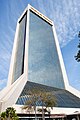 Wells Fargo Center (1974)
 EverBank Center (1983)
 Riverplace Tower (1967)
 The Carling (1925)
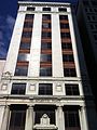 121 Atlantic Place (1909)


.jpg)


