
Florida: Difference between revisions
m →Recent elections: add 2000 census results and ref |
m →Education: put images in a table to eliminate blank space |
||
| Line 777: | Line 777: | ||
==Education== |
==Education== |
||
| ⚫ | |||
| ⚫ | |||
| ⚫ | |||
| ⚫ | |||
| ⚫ | |||
Florida's public primary and secondary schools are administered by the [[Florida Department of Education]]. |
Florida's public primary and secondary schools are administered by the [[Florida Department of Education]]. |
||
===State University System=== |
===State University System=== |
||
The [[State University System of Florida]] was founded in 1905, and is governed by the [[Florida Board of Governors]]. During the 2008 academic year 301,570 students attended one of these member institutions. |
The [[State University System of Florida]] was founded in 1905, and is governed by the [[Florida Board of Governors]]. During the 2008 academic year 301,570 students attended one of these member institutions. |
||
<table><tr> |
|||
| ⚫ | |||
| ⚫ | |||
| ⚫ | |||
===Private universities=== |
===Private universities=== |
||
Revision as of 20:06, 21 December 2010
Florida | |
|---|---|
| Country | United States |
| Before statehood | Florida Territory |
| Admitted to the Union | March 3, 1845 (27th) |
| Capital | Tallahassee |
| Largest city | Jacksonville |
| Largest metro and urban areas | South Florida metropolitan area |
| Government | |
| • Governor | Charlie Crist (I) |
| • Lieutenant Governor | Jeff Kottkamp (R) |
| Legislature | Florida Legislature |
| • Upper house | Senate |
| • Lower house | House of Representatives |
| U.S. senators | Bill Nelson (D) George LeMieux (R) |
| U.S. House delegation | 15 Republicans, 10 Democrats (list) |
| Population | |
| • Total | 18,537,969 (2,009 est.)[1] 15,982,378 (2,000) |
| • Density | 338.4/sq mi (130.67/km2) |
| • Median household income | $41,171 |
| • Income rank | 36th |
| Language | |
| • Official language | English [2] |
| • Spoken language | English and Spanish [3] |
| Traditional abbreviation | Fla. |
| Latitude | 24°27′ N to 31° N |
| Longitude | 80°02′ W to 87°38′ W |
Florida (/[invalid input: 'en-us-Florida.ogg']ˈflɒrɪdə/) is a state located in the Southeastern United States. It borders Alabama to the northwest and Georgia to the north. Much of the state's land mass is a large peninsula with the Gulf of Mexico to the west, the Atlantic Ocean to the east and the Caribbean to the south. Florida was admitted as the 27th U.S. state in 1845, after a three hundred year period of European rule.
With an area of 65,755 square miles (170,305 km2), it is ranked 22nd in size among the 50 U.S. states. Florida has the longest coastline in the contiguous United States, encompassing approximately 1,350 miles (2,170 km). The state has four large urban areas, a number of smaller industrial cities, and many small towns.
Florida is nicknamed the "Sunshine State" because of its generally warm climate—subtropical in the northern and central regions of the state, with a true tropical climate in the southern portion.[6] The United States Census Bureau estimates that the state population was 18,537,969 in 2009, ranking Florida as the fourth most populous state in the U.S.[7][8] Tallahassee is the state capital, Jacksonville is the largest city, and the South Florida metropolitan area is the largest metropolitan area.
History
Archaeological research indicates that Florida was first inhabited by Paleo-Indians, the first human inhabitants of the Americas, perhaps as early as 14 thousand years ago. The region was continuously inhabited through the Archaic period (to about 2000 BC). After about 500 BC the previously relatively uniform Archaic culture began to coalesce into distinctive local cultures.[9] By the 16th century, the earliest time for which there is a historical record, major Native American groups included the Apalachee (of the Florida Panhandle), the Timucua (of northern and central Florida), the Ais (of the central Atlantic coast), the Tocobaga (of the Tampa Bay area), the Calusa (of southwest Florida) and the Tequesta (of the southeastern coast).
Florida was the first part of what is now the continental United States to be visited by Europeans. The earliest known European explorers came with the Spanish conquistador Juan Ponce de León, who spotted the peninsula on April 2, 1513. According to his chroniclers, Ponce de León named the region La Florida ("flowery land") because it was then the Easter Season, known in Spanish as Pascua Florida (roughly "Flowery Easter"), and because the vegetation was in bloom.[10] It is possible Juan Ponce de León was not the first European to reach Florida, however; reportedly, at least one indigenous tribesman whom he encountered in Florida in 1513 spoke Spanish.[11] From 1513 onward, the land became known as "La Florida", although after 1630 and throughout the 18th century, Tegesta (after the Tequesta tribe) was an alternate name of choice for the Florida peninsula following publication of a map by the Dutch cartographer Hessel Gerritsz in Joannes de Laet's History of the New World.[12][13]

Over the following century, both the Spanish and French established settlements in Florida with varying degrees of success. In 1559, Don Tristán de Luna y Arellano established a colony at present-day Pensacola, one of the first European attempts at settlement in the continental United States. It was abandoned by 1561 due to hurricanes, famine and warring tribes, and the area was not re-inhabited until the 1690s. French Huguenots founded Fort Caroline in modern-day Jacksonville in 1564, but in the following year, the fort was conquered by forces from the new Spanish colony of St. Augustine (called San Agustín in Spanish). The Spanish maintained tenuous control over the region by converting the local tribes, briefly with Jesuits and later with Franciscan friars. The local leaders (caciques) demonstrated their loyalty to the Spanish by converting to Roman Catholicism and welcoming the Franciscan priests into their villages.[citation needed]

The area of Spanish Florida diminished with the establishment of English colonies to the north and French colonies to the west. The English weakened Spanish power in the area by supplying their Creek and Yamasee allies with firearms and urging them to raid the Timucuan and Apalachee client-tribes of the Spanish. The English attacked St. Augustine, burning the city and its cathedral to the ground several times, while the citizens hid behind the walls of the Castillo de San Marcos.
Florida was attracting a large number of Africans and African Americans from British-occupied North America who sought freedom from slavery. Once in Florida, the Spanish Crown converted them to Roman Catholicism and gave them freedom. Those ex-slaves settled in a community north of St. Augustine, called Gracia Real de Santa Teresa de Mose, the first freedom settlement of its kind in what became the United States. Many of those slaves were also welcomed by Creek and Seminole Native Americans who had established settlements there at the invitation of the Spanish government.
Great Britain gained control of Florida and other territory diplomatically in 1763 through the Peace of Paris. The British divided their new acquisitions into East Florida, with its capital at St. Augustine, and West Florida, with its capital at Pensacola. Britain tried to develop the Floridas through the importation of immigrants for labor, but this project ultimately failed. Spain received both Floridas after Britain's defeat by the American colonies and the subsequent Treaty of Versailles in 1783, continuing the division into East and West Florida. They offered land grants to anyone who settled in the colonies, and many Americans moved to them.

After settler attacks on Indian towns, Seminole Indians based in East Florida began raiding Georgia settlements, purportedly at the behest of the Spanish. The United States Army led increasingly frequent incursions into Spanish territory, including the 1817–1818 campaign against the Seminole Indians by Andrew Jackson that became known as the First Seminole War. Following the war, the United States effectively controlled East Florida. In 1819, by terms of the Adams-Onís Treaty, Spain ceded Florida to the United States in exchange for the American renunciation of any claims on Texas that they might have from the Louisiana Purchase and $5 million.
As settlement increased, pressure grew on the United States government to remove the Indians from their lands in Florida. To the chagrin of Georgia landowners, the Seminoles harbored and integrated runaway blacks, known as the Black Seminoles, and clashes between whites and Indians grew with the influx of new settlers. In 1832, the United States government signed the Treaty of Payne's Landing with some of the Seminole chiefs, promising them lands west of the Mississippi River if they agreed to leave Florida voluntarily. Many of the Seminoles left at this time, while those who remained prepared to defend their claims to the land. The U.S. Army arrived in 1835 to enforce the treaty under pressure from white settlers, and the Second Seminole War began at the end of the year with the Dade Massacre, when Seminoles ambushed and killed or mortally wounded all but one in a group of 110 Army troops, plus Major Dade and seven officers, marching from Fort Brooke (Tampa) to reinforce Fort King (Ocala).[14] Between 900 and 1,500 Seminole Indian warriors employed guerrilla tactics against United States Army troops for seven years until 1842. The U.S. government is estimated to have spent between US$20 million and US$40 million on the war, at the time an astronomical sum.

On March 3, 1845, Florida became the 27th state of the United States of America, although initially its population grew slowly. White settlers continued to encroach on lands used by the Seminoles, and the United States government resolved to make another effort to move the remaining Seminoles to the West. The Third Seminole War lasted from 1855 to 1858, and resulted in the removal of most of the remaining Seminoles. Even after three bloody wars, the U.S. Army failed to force all of the Seminole Indians in Florida to the West.[15] Though most of the Seminoles were forcibly exiled to Creek lands west of the Mississippi, hundreds, including Seminole leader Aripeka (Sam Jones), remained in the Everglades and refused to leave the native homeland of their ancestors. Their descendants remain there to this day.

White settlers began to establish cotton plantations in Florida, which required numerous laborers. By 1860 Florida had only 140,424 people, of whom 44% were enslaved. There were fewer than 1000 free African Americans before the Civil War.[16]

On January 10, 1861, before the start of the American Civil War, Florida declared its secession from the Union; ten days later, the state became a founding member of the Confederate States of America. The war ended in 1865. On June 25, 1868, Florida's congressional representation was restored. After Reconstruction, white Democrats succeeded in regaining power in the state legislature. In 1885 they created a new constitution, followed by statutes through 1889 that effectively disfranchised most blacks and many poor whites over the next several years. Provisions included poll taxes, literacy tests, and residency requirements. Disfranchisement for most African Americans in the state persisted until the Civil Rights Movement of the 1960s gained federal legislation to protect their suffrage.

Until the mid-20th century, Florida was the least populous Southern state. In 1900 its population was only 528,542, of whom nearly 44% were African American.[17] The boll weevil devastated cotton crops, and early 20th century lynchings and racial violence caused a record number of African Americans to leave the state in the Great Migration to northern and midwestern industrial cities. Forty thousand blacks, roughly one-fifth of their 1900 population, left for better opportunities.[18] National economic prosperity in the 1920s stimulated tourism to Florida. Combined with its sudden elevation in profile was the Florida land boom of the 1920s, which brought a brief period of intense land development. Devastating hurricanes in 1926 and 1928, followed by the stock market crash and Great Depression, brought that period to a halt.
Florida's economy did not fully recover until the buildup for World War II. The climate, tempered by the growing availability of air conditioning, and low cost of living made the state a haven. Migration from the Rust Belt and the Northeast sharply increased the population after the war. In recent decades, more migrants have come for the jobs in a developing economy. Today, with an estimated population of more than 18 million, Florida is the most populous state in the Southeastern United States, the second most populous state in the South behind Texas, and the fourth most populous in the United States. The Census Bureau estimated that "Florida, now the fourth most populous state, will edge past New York into third place in total population by 2011".[19]
Geography

Much of the state of Florida is situated on a peninsula between the Gulf of Mexico, the Atlantic Ocean, and the Straits of Florida. Spanning two time zones, It extends to the northwest into a panhandle, extending along the northern Gulf of Mexico. It is bordered on the north by the states of Georgia and Alabama, and on the west, at the end of the panhandle, by Alabama. It is near several Caribbean countries, particularly The Bahamas and Cuba. Florida's extensive coastline made it a perceived target during World War II, so the government built airstrips throughout the state; today, approximately 400 airports are still in service. According to the National Drug Intelligence Center, Florida has 131 public airports, and more than 700 private airports, airstrips, heliports, and seaplane bases.[20] Florida is one of the largest states east of the Mississippi River, and only Alaska and Michigan are larger in water area.


At 345 feet (105 m) above mean sea level, Britton Hill is the highest point in Florida and the lowest highpoint of any U.S. state.[21] Much of the state south of Orlando is low-lying and fairly level; however, some places, such as Clearwater, feature vistas that rise 50 to 100 feet (15– 30 m) above the water. Much of Central and North Florida, typically 25 miles (40 km) or more away from the coastline, features rolling hills with elevations ranging from 100 to 250 feet (30– 76 m). The highest point in peninsular Florida, Sugarloaf Mountain, is a 312-foot (95 m) peak in Lake County.[22]
Areas under control of the National Park Service include:[23]
- Big Cypress National Preserve, near Lake Okeechobee
- Biscayne National Park, in Miami-Dade County south of Miami
- Canaveral National Seashore, between New Smyrna Beach and Titusville
- Castillo de San Marcos National Monument, in St. Augustine
- De Soto National Memorial, in Bradenton
- Dry Tortugas National Park, at Key West
- Everglades National Park in Southern Florida
- Fort Caroline National Memorial, at Jacksonville
- Fort Matanzas National Monument, in St. Augustine
- Gulf Islands National Seashore, near Gulf Breeze
- Timucuan Ecological and Historic Preserve, in Jacksonville
Areas under the control of the USDA United States Forest Service include:
- Apalachicola National Forest along the east bank of the Apalachicola River,
- Choctawhatchee National Forest near Niceville,
- Ocala National Forest in Central Florida, and
- Osceola National Forest in Northeast Florida.
Boundaries
The state line begins in the Atlantic Ocean, traveling west, south, and north up the thalweg of the Saint Mary's River. At the origin of that river, it then follows a straight line nearly due west and slightly north, to the point where the confluence of the Flint River (from Georgia) and the Chattahoochee River (down the Alabama/Georgia line) used to form Florida's Apalachicola River. (Since Woodruff Dam was built, this point has been under Lake Seminole.) The border with Georgia continues north through the lake for a short distance up the former thalweg of the Chattahoochee, then with Alabama runs due west along latitude 31°N to the Perdido River, then south along its thalweg to the Gulf via Perdido Bay. Much of the state is at or near sea level.
Climate

The climate of Florida is tempered somewhat by the fact that no part of the state is very distant from the ocean. North of Lake Okeechobee, the prevalent climate is humid subtropical, while coastal areas south of the lake (including the Florida Keys) have a true tropical climate.[24] High temperatures in the state seldom exceed 100 °F (38 °C), with much of Florida commonly seeing a high summer temperature of 90s °F (32+ °C).
During late autumn and winter months, Florida has experienced occasional cold fronts that can bring high winds and relatively cooler temperatures for the entire state, with high temperatures that could remain into the 40s and 50s (4 to 15 °C) and lows of 20s and 30s (-7 to 4 °C). Several record highs have been in the 30s and record lows have been in the 10s. These temperatures extend normally a few days at a time in the northern and central parts of Florida. Southern Florida, however, rarely encounters below-freezing temperatures.


The hottest temperature ever recorded in Florida was 109 °F (43 °C), which was set on June 29, 1931 in Monticello. The coldest temperature was –2 °F (−19 °C), on February 13, 1899, just 25 miles (40 km) away, in Tallahassee. Mean high temperatures for late July are primarily in the low 90s Fahrenheit (32–35 °C). Mean low temperatures for late January range from the low 40s Fahrenheit (4–7 °C) in northern Florida to the mid-50s (≈13 °C) in southern Florida.
The seasons in Florida are determined more by precipitation than by temperature, with the hot, wet springs and summers making up the wet season, and mild to cool, and the relatively dry winters and autumns, making the dry season. Fall foliage appears in Central and North Florida starting around late November, and into winter.
The Florida Keys, because they are completely surrounded by water, have lesser variability in temperatures. At Key West, temperatures rarely exceed 90 °F (32 °C) in the summer or fall below 60 °F (16 °C) in the winter, and frost has never been reported in the Keys.
Florida's nickname is the "Sunshine State", but severe weather is a common occurrence in the state. Central Florida is known as the lightning capital of the United States, as it experiences more lightning strikes than anywhere else in the country.[25] Florida has the highest average precipitation of any state, in large part because afternoon thunderstorms are common in most of the state from late spring until early autumn. A fair day may be interrupted with a storm, only to return to sunshine an hour or so later. These thunderstorms, caused by overland collisions of moist masses of air from the Gulf of Mexico and Atlantic Ocean[citation needed], pop up in the early afternoon and can bring heavy downpours, high winds, and sometimes tornadoes. Florida leads the United States in tornadoes per square mile (when including waterspouts)[26] but they do not typically reach the intensity of those in the Midwest and Great Plains. Hail often accompanies the most severe thunderstorms.
Snow in Florida is a rare occurrence, especially on the peninsula. During the Great Blizzard of 1899, Florida experienced blizzard conditions; the Tampa Bay area had "gulf-effect" snow, similar to lake-effect snow in the Great Lakes region.[27] During the 1899 blizzard was the only time the temperature in Florida is known to have fallen below 0 degrees Fahrenheit (−18 °C). The most widespread snowfall in Florida history occurred on January 19, 1977, when snow fell over much of the state, with flurries as far south as Homestead. Snow flurries also fell on Miami Beach for the only time in recorded history. A hard freeze in 2003 brought "ocean-effect" snow flurries to the Atlantic coast as far south as Cape Canaveral.[28] The 1993 Superstorm brought blizzard conditions to the panhandle, while heavy rain and tornadoes beset the peninsula. The storm is believed to have been similar in composition to a hurricane, some Gulf coast regions even seeing storm surges of six feet or more. More recently, traces of snow and sleet fell across central and southern Florida during a hard freeze event in January, 2010. There was some slight accumulation north of the I-4 corridor, mostly in the form of sleet.[29]

Hurricanes pose a severe threat during hurricane season, which lasts from June 1 to November 30, although some storms have been known to form out of season. Florida is the most hurricane-prone US state, with subtropical or tropical water on a lengthy coastline. From 1851 to 2006, Florida has been struck by 114 hurricanes, 37 of them major—category 3 and above.[30] It is rare for a hurricane season to pass without any impact in the state by at least a tropical storm. For storms, category 4 or higher, 83% have either hit Florida or Texas.[30] August to October is the most likely period for a hurricane in Florida.
In 2004, Florida was hit by a record four hurricanes. Hurricanes Charley (August 13), Frances (September 4–5), Ivan (September 16), and Jeanne (September 25–26) cumulatively cost the state's economy $42 billion. Additionally, the four storms caused an estimated $45 billion in damage.[31] In 2005, Hurricane Dennis (July 10) became the fifth storm to strike Florida within eleven months. Later, Hurricane Katrina (August 25) passed through South Florida and Hurricane Rita (September 20) swept through the Florida Keys. Hurricane Wilma (October 24) made landfall near Cape Romano, just south of Marco Island, finishing another very active hurricane season. Wilma is the second most expensive hurricane in Florida history, due in part to a five year window in which to file claims.[32]
Florida was the site of the second costliest weather disaster in U.S. history, Hurricane Andrew, which caused more than US$25 billion in damage when it struck on August 24, 1992. In a long list of other infamous hurricane strikes are the 1926 Miami hurricane, the 1928 Okeechobee hurricane, the Labor Day Hurricane of 1935, Hurricane Donna in 1960, and Hurricane Opal in 1995. Recent research suggests the storms are part of a natural cycle and not a result of global warming.[33][34]
| Average High and Low temperatures for various Florida Cities | ||||||||||||
| City | Jan | Feb | Mar | Apr | May | Jun | Jul | Aug | Sep | Oct | Nov | Dec |
| Jacksonville[35] | 65/43 | 68/45 | 74/50 | 80/56 | 86/64 | 90/70 | 92/73 | 91/73 | 87/70 | 80/61 | 73/51 | 66/44 |
| Key West[36] | 75/65 | 76/66 | 79/69 | 82/72 | 85/76 | 88/78 | 89/80 | 90/80 | 88/78 | 85/76 | 80/71 | 76/67 |
| Melbourne[37] | 72/51 | 73/53 | 77/57 | 81/61 | 85/67 | 88/71 | 90/73 | 90/73 | 88/72 | 83/67 | 78/60 | 73/53 |
| Miami[38] | 76/60 | 77/61 | 80/64 | 83/68 | 86/72 | 88/75 | 90/77 | 90/77 | 88/76 | 85/72 | 81/67 | 77/62 |
| Pensacola[39] | 61/43 | 64/46 | 70/51 | 76/58 | 84/66 | 89/72 | 90/74 | 90/74 | 87/70 | 80/60 | 70/50 | 63/45 |
| Tallahassee[40] | 64/40 | 67/42 | 73/48 | 80/53 | 87/62 | 91/69 | 91/72 | 91/72 | 88/68 | 81/57 | 72/47 | 66/41 |
| Tampa[41] | 71/51 | 72/52 | 77/57 | 82/62 | 88/68 | 90/73 | 90/75 | 90/75 | 89/73 | 84/66 | 77/58 | 72/52 |
Fauna


Florida is host to many types of wildlife including:
- Marine Mammals: Bottlenose Dolphin, Short-finned Pilot Whale, North Atlantic Right Whale, West Indian Manatee
- Reptiles: American Alligator and Crocodile, Eastern Diamondback and Pygmy Rattlesnakes, Gopher Tortoise, Green and Leatherback Sea Turtles, Eastern Indigo Snake
- Mammals: Florida panther, Northern River Otter, Mink, Eastern Cottontail Rabbit, Marsh Rabbit, Raccoon, Striped Skunk, Squirrel, White-tailed deer, Key Deer, Bobcats, Gray Fox, Coyote, Wild Boar, Florida Black Bear, Nine-banded Armadillos
- Birds: Bald Eagle, Northern Caracara, Snail Kite, Osprey, White and Brown Pelicans, Sea Gulls, Whooping and Sandhill Cranes, Roseate Spoonbill, Florida Scrub Jay (state endemic), and others. One subspecies of Wild Turkey, Meleagris gallopavo, namely subspecies osceola, is found only in the state of Florida.[42] The state is a wintering location for many species of eastern North American birds.
- Invertebrates: carpenter ants, termites, and American cockroach.
The only known calving area for the Northern Right Whale is off the coasts of Florida and Georgia.[43]
Since their accidental importation from South America into North America in the 1930s, the Red imported fire ant population has increased its territorial range to include most of the Southern United States, including Florida. They are more aggressive than most native ant species and have a painful sting.[44]
A number of non-native snakes have been released in the wild. In 2010 the state created a hunting season for Burmese and Indian pythons, African rock pythons, green anacondas, and Nile monitor lizards.[45]
Environmental issues
Florida ranks 45th out of 50 states in total energy consumption per capita, despite the heavy reliance on air conditioners and pool pumps. This includes coal, natural gas, petroleum, and retail electricity sales.[46] It is estimated that approximately 4% of energy in the state is generated through renewable resources.[47] Florida's energy production is 6% of the nation's total energy output, while total production of pollutants is lower, with figures of 5.6% for nitrogen oxide, 5.1% for carbon dioxide, and 3.5% for sulfur dioxide.[47]
It is believed that significant energy resources are located off of Florida's western coast in the Gulf of Mexico, but that region has been closed to exploration since 1981.[48] Governor Charlie Crist and both of Florida's U.S. Senators, Bill Nelson and Mel Martinez, oppose offshore drilling and exploration. Former Governor Jeb Bush, who was originally opposed to all drilling,[49] changed his position in 2005 when he supported a bill introduced into the House of Representatives which allowed unrestricted drilling 125 miles (201 km) or more from the coast.[50] Crist, Martinez and Nelson opposed that bill, but Martinez and Nelson voted for a Senate alternative which prohibited drilling within 125 miles (201 km) of the Panhandle coast, and 235 miles (378 km) of the peninsular coast.[51]
In July 2007, Florida Governor Charlie Crist announced plans to sign executive orders that would impose strict new air-pollution standards in the state, with aims to reduce greenhouse gas emissions by 80% of 1990 levels by 2050. Crist's orders would set new emissions targets for power companies, automobiles and trucks, and toughen conservation goals for state agencies and require state-owned vehicles to use alternative fuels.[52]
Red tide has been an issue on the Southwest coast of Florida, as well as other areas. While there has been a great deal of conjecture over the cause of the toxic algae bloom, there is no evidence that it is being caused by pollution or that there has been an increase in the duration or frequency of red tides.[53]
The Florida panther is close to extinction. A record 23 were killed in 2009 by hunters and in car accidents which leaves only about 100 individuals in the wild. The Center for Biological Diversity and others have therefore called for a special protected area for the panther to be established.[54] Manatees are also dying at a rate higher than their reproduction.
Geology
The Florida peninsula is a porous plateau of karst limestone sitting atop bedrock known as the Florida Platform. The emergent portion of the platform was created during the Eocene to Oligocene as the Gulf Trough filled with silts, clays, and sands. Flora and fauna began appearing during the Miocene. No land animals were present in Florida prior to the Miocene.
The largest deposits of potash in the country are found in Florida.[55]
Extended systems of underwater caves, sinkholes and springs are found throughout the state and supply most of the water used by residents. The limestone is topped with sandy soils deposited as ancient beaches over millions of years as global sea levels rose and fell. During the last glacial period, lower sea levels and a drier climate revealed a much wider peninsula, largely savanna.[56] The Everglades, an enormously wide, very slow-flowing river encompasses the southern tip of the peninsula.
Florida is tied for last place[57] as having the fewest earthquakes of any US state.[58] Because Florida is not located near any tectonic plate boundaries, earthquakes are very rare, but not totally unknown. In January, 1879, a shock occurred near St. Augustine. There were reports of heavy shaking that knocked plaster from walls and articles from shelves. Similar effects were noted at Daytona Beach 50 miles (80 km) south. The tremor was felt as far south as Tampa and as far north as Savannah, Georgia. In January 1880, Cuba was the center of two strong earthquakes that sent severe shock waves through the city of Key West, Florida.[59] Another earthquake centered outside Florida was the 1886 Charleston earthquake. The shock was felt throughout northern Florida, ringing church bells at St. Augustine and severely jolting other towns along that section of Florida's east coast. Jacksonville residents felt many of the strong aftershocks that occurred in September, October, and November 1886.[60] As recently as 2006, a magnitude 6.0 earthquake centered about 260 miles (420 km) southwest of Tampa in the Gulf of Mexico sent shock waves through southwest and central Florida. The earthquake was too small to trigger a tsunami and no damage was reported.[61]
Demographics
Population
| Census | Pop. | Note | %± |
|---|---|---|---|
| 1830 | 34,730 | — | |
| 1840 | 54,477 | 56.9% | |
| 1850 | 87,445 | 60.5% | |
| 1860 | 140,424 | 60.6% | |
| 1870 | 187,748 | 33.7% | |
| 1880 | 269,493 | 43.5% | |
| 1890 | 391,422 | 45.2% | |
| 1900 | 528,542 | 35.0% | |
| 1910 | 752,619 | 42.4% | |
| 1920 | 968,470 | 28.7% | |
| 1930 | 1,468,211 | 51.6% | |
| 1940 | 1,897,414 | 29.2% | |
| 1950 | 2,771,305 | 46.1% | |
| 1960 | 4,951,560 | 78.7% | |
| 1970 | 6,789,443 | 37.1% | |
| 1980 | 9,746,324 | 43.6% | |
| 1990 | 12,937,926 | 32.7% | |
| 2000 | 15,982,378 | 23.5% | |
| 2009 (est.) | 18,537,969 |
Florida has the 4th highest state population in the United States. The center of population of Florida is located in Polk County, in the town of Lake Wales.[62] As of 2009, Florida's population was estimated to be 18,537,969. The state grew 128,814, or 0.7% from 2007. Using the latest population estimates, Florida is the nation's thirtieth-fastest-growing state. During Florida's peak growth year of 2005, it was the nation's fifth fastest growing state and grew at an annual rate of 2.2%.[1]
About two-thirds of the population was born in another state, the second highest in the country.[63]
The state had the third largest illegal immigrant population in the country in 2009.[64]b In 2010, illegal immigrants constituted an estimated 5.7% of the population. This was the sixth highest percentage of any state in the country.[65][66]
There were 186,102 military retirees living in the state in 2008.[67]
Ancestry groups
| By race | White | Black | AIAN* | Asian | NHPI* |
|---|---|---|---|---|---|
| 2000 (total population) | 82.45% | 15.66% | 0.75% | 2.11% | 0.16% |
| 2000 (Hispanic only) | 15.94% | 0.74% | 0.14% | 0.09% | 0.03% |
| 2005 (total population) | 81.47% | 16.31% | 0.84% | 2.52% | 0.18% |
| 2005 (Hispanic only) | 18.48% | 0.87% | 0.21% | 0.11% | 0.04% |
| Growth 2000–05 (total population) | 9.99% | 15.93% | 23.95% | 33.09% | 29.08% |
| Growth 2000–05 (non-Hispanic only) | 5.43% | 15.23% | 15.67% | 32.55% | 24.49% |
| Growth 2000–05 (Hispanic only) | 28.99% | 29.93% | 58.98% | 45.89% | 45.66% |
| * AIAN is American Indian or Alaskan Native; NHPI is Native Hawaiian or Pacific Islander | |||||
Racial and ancestral makeup
The largest reported ancestries in the 2000 Census were English (16.9%), German (11.8%), Irish (10.3%), Italian (6.3%), French (2.8%), Polish (2.7%) and Scottish (1.8%). In the 2000 Census, 62,919 people in Florida self-identified as having "American" ancestry, most of these people are of English descent and some are of Scots-Irish descent however have families that have been in the state so long, in many cases since the colonial period, that they choose to identify simply as having "American" ancestry or do not in fact know their own ancestry.[68][69][70][71][72][73]

Before the American Civil War, when slavery was legal, and during the Reconstruction era that followed, blacks made up nearly half of the state's population.[74] Their proportion declined over the next century, as many moved north in the Great Migration while large numbers of northern whites moved to the state. Recently, the state's proportion of black residents has begun to grow again. Today, large concentrations of black residents can be found in northern Florida (notably in Jacksonville, Gainesville, Tallahassee, and Pensacola), the Tampa Bay area, the Orlando area, especially in Orlando and Sanford. Also, there has been a large increase of Black Americans of Hispanic descent in South Florida;[citation needed] where their numbers have been bolstered by significant immigration from Cuba, Dominican Republic, and small numbers from Spanish speaking countries in South America.[citation needed]
Florida's Hispanic population includes large communities of Cuban Americans in Miami and Tampa, Puerto Ricans in Orlando and Tampa, and Central American migrant workers in inland West-Central and South Florida. The Hispanic community continues to grow more affluent and mobile. Between the years of 2000 and 2004, Lee County in Southwest Florida, which is largely suburban in character, had the fastest Hispanic population growth rate of any county in the United States.
White Americans of all European backgrounds are present in all areas of the state. Those of English and Irish ancestry are present in large numbers in all the urban/suburban areas across the state. There is a large German population in Southwest Florida, a large Greek population in the Tarpon Springs area, a sizable Italian, Spanish, and Russian communities in Miami, and white Floridians of longer-present generations in the culturally southern areas of inland and northern Florida.[citation needed] Native white Floridians, especially those who have descended from long-time Florida families, affectionately refer to themselves as "Florida crackers." Like all the other southern states, they descend mainly from English and Scots-Irish settlers, as well as some other British settlers.[75] In and around St. Augustine are also several descendants of the Minorcans who fled there from British physician Andrew Turnbull's New Smyrna colony in 1768.[76]
Metropolitan areas

| Largest cities in Florida[77] | ||
|---|---|---|
| City population > 500,000 | ||
| City | Population | Metropolitan area |
|
813,518 |
||
| City population > 200,000 | ||
| City | Population | Metropolitan area |
|
433,136 |
||
| City population > 150,000 | ||
| City | Population | Metropolitan area |
|
184,892 |
South Florida | |
| City population > 100,000 | ||
| City | Population | Metropolitan area |
|
Pembroke Pines |
146,600 |
South Florida |
| Largest metropolitan areas in Florida | ||
|---|---|---|
| Rank | Metropolitan Area | Population |
| 1 | South Florida | 5,463,857 |
| 2 | Tampa Bay | 2,733,761 |
| 3 | Orlando | 2,082,421 |
| 4 | Jacksonville | 1,313,228 |
| 5 | Bradenton-Sarasota | 688,126 |
The largest metropolitan area in the state as well as the entire southeastern United States is the South Florida metropolitan area, with about 5.5 million people. The Tampa Bay area, with over 2.7 million people, is the second largest metro area and Greater Orlando, with over 2 million people, is the third.
Florida has twenty Metropolitan Statistical Areas (MSAs) defined by the United States Office of Management and Budget (OMB). Thirty-nine of Florida's sixty-seven counties are in an MSA. Reflecting the distribution of population in Florida, Metropolitan areas in the state are concentrated around the coast of the peninsula. They form a continuous band on the east coast of Florida, stretching from the Jacksonville MSA to the Miami-Fort Lauderdale-Pompano Beach MSA, including every county on the east coast, with the exception of Monroe County. There is also a continuous band of MSAs on the west coast of the peninsula from the Tampa-St. Petersburg-Clearwater MSA to the Naples-Marco Island MSA, including all of the coastal counties from Hernando County to Collier County. The interior of the northern half of the peninsula also has several MSAs, connecting the east and west coast MSAs. A few MSAs are scattered across the Florida panhandle.


Languages
As of 2000, 76.91% of Florida residents age 5 and older spoke English at home as a first language, while 16.46% spoke Spanish, and French Creole (predominantly Haitian Creole) was spoken by 1.38% of the population. French was spoken by 0.83%, followed by German at 0.59%, and Italian at 0.44% of all residents. Also, Portuguese comprised 0.36%, while Tagalog made up 0.25% of speakers, Arabic was at 0.21% and Vietnamese at 0.20%. In all, 23.80% of Florida's population age 5 and older spoke a language other than English at home.[78]
As of 2005, 74.54% of Florida residents age 5 and older spoke English at home as a first language, while 18.65% spoke Spanish, and French Creole (predominantly Haitian Creole) was spoken by 1.73% of the population. French was spoken by 0.63%, followed by German at 0.45%, and Portuguese at 0.44% of all residents. Also, Italian comprised 0.32%, while Tagalog made up 0.30% of speakers, Vietnamese was at 0.25% and Arabic at 0.23%. In all, 25.45% of Florida's population age 5 and older spoke a language other than English.[79]
This means English decreased by -2.37%, Spanish increased +2.21%, French Creole (including Haitian Creole) increased by +0.35%, French decreased by -0.20%, German decreased by -0.14%, Italian decreased by -0.12%, Portuguese increased by +0.08%, Tagalog increased by +0.05%, Arabic increased by +0.02%, and Vietnamese increased by +0.05% of languages spoken.[80]
Florida's climate makes it a popular state for immigrants. Florida's public education system identifies over 200 first languages other than English spoken in the homes of students. In 1990, the League of United Latin American Citizens (LULAC) won a class action lawsuit against the state Florida Department of Education that required educators to be trained in teaching English for Speakers of Other Languages (ESOL).
Article II, Section 9, of the Florida Constitution provides that "English is the official language of the State of Florida." This provision was adopted in 1988 by a vote following an Initiative Petition.
Religion
As of the year 2000, the three largest denominational groups in Florida are Catholic, Evangelical Protestant, and Mainline Protestant.[81] The Catholic Church has the highest number of adherents in Florida (at 2,596,148), followed by the Southern Baptist Convention with 1,292,097 members reported and Judaism reporting 628,485 adherents.
Florida is mostly Protestant, but Roman Catholicism is the single largest denomination in the state. There is also a sizable Jewish community, located mainly in South Florida; no other Southern state has such a large Jewish population. Florida's current religious affiliations are shown in the table below:[82]

- Roman Catholic, 26%
- Protestant, 48%
- Baptist, 9%
- Methodist, 6%
- Pentecostal, 3%
- Jewish, 3%
- Jehovah's Witness, 1%
- Muslim, 1%
- Orthodox, 1%
- other religions, 1%
- non-religious, 16%
Government

The basic structure, duties, function, and operations of the government of the State of Florida are defined and established by the Florida Constitution, which establishes the basic law of the state and guarantees various rights and freedoms of the people. The state government consists of three separate branches: judicial, executive, and legislative. The legislature enacts bills, which, if signed by the governor, become Florida Statutes.
The Florida Legislature comprises the Florida Senate, which has 40 members, and the Florida House of Representatives, which has 120 members. The current Governor of Florida is Charlie Crist. The Florida Supreme Court consists of a Chief Justice and six Justices.
There are 67 Counties in Florida, but some reports show only 66 because of Duval County, which is consolidated with the City of Jacksonville. There are 379 cities in Florida (out of 411) that report regularly to the Florida Department of Revenue, but there are other incorporated municipalities that do not. The primary source of revenue for the State government is sales tax, but the primary revenue source for cities and counties is property tax.
Political history
After Reconstruction, white-elite Democrats wrestled for power until they regained it in 1877, partly through violent paramilitary tactics targeting freedmen and allies to reduce their voting.[citation needed] From 1885 to 1889, the state legislature passed statutes with provisions to reduce voting by blacks and poor whites, which had threatened white Democratic power with a populist coalition. As these groups were stripped from voter rolls, white Democrats established power in a one-party state, as happened across the South. In 1900 African Americans comprised 44% of the state's population,[83] the same proportion as before the Civil War, but they were effectively disfranchised. From 1877 to 1948, Florida voted for the Democratic candidate for president in every election except for the 1928 election.

In response to segregation, disfranchisement and agricultural depression, many African Americans migrated from Florida to northern cities in the Great Migration, in waves from 1910–1940, and again starting in the later 1940s. They moved for jobs, better education for their children and the chance to vote and participate in society. Given migration of other groups into Florida (as noted in other sections of this article), by 1960 the proportion of African Americans in the state had declined to 18%.[84]
Since 1952, despite having a majority of registered Democrats, the state has voted for the Republican presidential candidate in every election except for the 1964, 1976, and 1996 elections, when the Democrat was from the South, and the 2008 election, which was the first time since FDR that Florida had voted for a Northern Democrat. The first post-reconstruction Republican congressional representative was elected in 1954.[85] The state's first post-reconstruction Republican senator was elected in 1968,[86] two years after the first post-reconstruction Republican governor.[87]
| Year | Republican | Democratic |
|---|---|---|
| 2008 | 48.22% 4,045,624 | 50.96% 4,282,074 |
| 2004 | 52.10% 3,964,522 | 47.09% 3,583,544 |
| 2000 | 48.85% 2,912,790 | 48.84% 2,912,253 |
| 1996 | 42.32% 2,244,536 | 48.02% 2,546,870 |
| 1992 | 40.89% 2,173,310 | 39.00% 2,072,698 |
| 1988 | 60.87% 2,618,885 | 38.51% 1,656,701 |
| 1984 | 65.32% 2,730,350 | 34.66% 1,448,816 |
| 1980 | 55.52% 2,046,951 | 38.50% 1,419,475 |
| 1976 | 46.64% 1,469,531 | 51.93% 1,636,000 |
| 1972 | 71.91% 1,857,759 | 27.80% 718,117 |
| 1968 | 40.53% 886,804 | 30.93% 676,794 |
| 1964 | 48.85% 905,941 | 51.15% 948,540 |
| 1960 | 51.51% 795,476 | 48.49% 748,700 |
In 1998, Democrats were described as most dominant in areas of the state with high percentages of racial minorities, as well as transplanted white liberals coming primarily from the Northeastern United States.[88] The South Florida metropolitan area was a good example of this as it had a particularly high level of both racial minorities and white liberals. Because of this, the area has been one of the most Democratic areas of the state. The Daytona metropolitan area has been, to a lesser extent, somewhat similar to South Florida demographically and the city of Orlando had a large Hispanic population, which often favored Democrats. Republicans remain dominant through out much of the rest of Florida particularly in the more rural and suburban areas, as is the case throughout the Deep South.[88]
The fast growing I-4 corridor area, which runs through Central Florida and connects the cities of Daytona Beach, Orlando, and Tampa/St. Petersburg, had a fairly similar number of both Republican and Democratic voters. The area is often seen as a merging point of the conservative northern portion of the state and the liberal southern portion making it the biggest swing area in the state. In recent times, whichever way the I-4 corridor area, containing 40% of Florida voters, votes has often determined who will win the state of Florida in presidential elections.[89]
The Democratic Party has maintained an edge in voter registration, both statewide and in 40 of the 67 counties, including Miami-Dade County, Broward County, and Palm Beach County, the state's three most populous counties.[90]
Recent elections
In 2000, George W. Bush won the U.S. Presidential election by a margin of 271-266 in the Electoral College.[91] Of the 271 electoral votes for Bush, 25 were cast by electors from Florida.[92] Reapportionment following the 2000 United States Census gave the state two more seats in the House of Representatives.[93]
Despite the Democratic advantage in registration, as of 2008, Republicans controlled the governorship and most other statewide elective offices; both houses of the state legislature; and 15 of the state's 25 seats in the House of Representatives. Florida has been listed as a swing state in Presidential elections since 1950, voting for the losing candidate once in that period of time.[94] In the closely contested 2000 election the state played a pivotal role.[91][92][95][96][97][98]
In 2008, delegates of both the Republican Florida primary election and Democratic Florida primary election were stripped of half of their votes when the conventions met in August due to violation of both parties' national rules.
In the 2010 elections, Republicans solidified their dominance state-wide, by winning the governor's mansion, maintaining firm majorities in both houses of the state legislature. They won four previously Democratic-held seats to create a 19-6 Republican majority delegation representing Florida in the federal House of Representatives. As a result of the 2010 United States Census, Florida will gain two House of Representative seats in 2012.[93]
Statutes
All potable water resources have been controlled by the state government through five regional water authorities since 1972.[99]
The state repealed mandatory auto inspection in 1981.[100]
Health and public safety
Florida was ranked the fifth most dangerous state in 2009. Ranking was based on the record of serious felonies committed in 2008.[101]
In 2009, 44% of highway fatalities involved alcohol.[102]
There were 2.7 million Medicaid patients in Florida in 2009. The governor has proposed adding $2.6 billion to care for the expected 300,000 additional patients in 2011.[103]
Medicaid paid for 60% of all births in Florida in 2009.[104]
The state has a program for those not covered by Medicaid.
Some people suffer from various allergies from plants at varying seasons including pollen from oak trees and juniper shrubs.[105]
Architecture
While many houses and commercial buildings look similar to those elsewhere in the country, the state has appropriated some unique styles in some section of the state including Spanish revival, Florida vernacular, and Mediterranean Revival Style.[106][107]
Economy


The Gross Domestic Product (GDP) of Florida in 2007 was $734.5 billion. Its GDP is the fourth largest economy in the United States.[110] The major contributors to the state's gross output in 2007 were general services, financial services, trade, transportation and public utilities, manufacturing and construction respectively. In 2009, the state government had a budget of $66.5 billion.[31]
Personal income
In 2009, Per Capita personal income was $37,780, ranking 24th in the nation.[111]
The state was one of the few states to not have a state minimum wage law until 2004, when voters passed a constitutional amendment establishing a state minimum wage and (unique among minimum wage laws) mandating that it be adjusted for inflation annually. For 2010, the calculated Florida minimum wage was lower than the Federal rate of $7.25, so the Federal rate controlled.[112]
Florida is one of the seven states that do not impose a personal income tax.
There were 2.4 million Floridians living in poverty in 2008. 18.4% of children 18 and younger were living in poverty.[113]
The state also had the second-highest credit card delinquency rate, with 1.45% of cardholders in the state more than 90 days delinquent on one or more credit cards.[114]
In 2010, over 2.5 million Floridians were on food stamps, up from 1.2 million in 2007. To qualify Floridians must make less than 133% of the federal poverty level. Under $29,000 for a family of four.[115]
Real estate
In the early 20th century, land speculators discovered Florida, and businessmen such as Henry Plant and Henry Flagler developed railroad systems, which led people to move in, drawn by the weather and local economies. From then on, tourism boomed, fueling a cycle of development that overwhelmed a great deal of farmland.
Because of the collective effect on the insurance industry of the hurricane claims of 2004, homeowners insurance has risen 40% to 60% and deductibles have risen.[31]
At the end of the third quarter in 2008, Florida had the highest mortgage delinquency rate in the country, with 7.8% of mortgages delinquent at least 60 days.[114] A 2009 list of national housing markets that were hard hit in the real estate crash included a disproportionate number in Florida.[116] The early 21st century building boom left Florida with 300,000 vacant homes in 2009, according to state figures.[117] In 2009, the US Census Bureau estimated that Floridians spent an average 49.1% of personal income on housing-related costs, the third highest percentage in the country.[118]
In the third quarter of 2009, there were 278,189 delinquent loans, 80,327 foreclosures.[119] Sales of existing homes for February 2010 was 11,890, up 21% from the same month in 2009. Only two metropolitan areas showed a decrease in homes sold: Panama City and Brevard County. The average sales price for an existing house was $131,000, 7% decrease from the prior year.[120]
Labor
As of January 2010, the state's unemployment rate was 11.9%.[121]
Tourism
Tourism makes up the largest sector of the state economy. Warm weather and hundreds of miles of beaches attract about 60 million visitors to the state every year. Amusement parks, especially in the Orlando area, make up a significant portion of tourism. The Walt Disney World Resort is the largest vacation resort in the world, consisting of four theme parks and more than 20 hotels in Lake Buena Vista, Florida; it, and Universal Orlando Resort, Busch Gardens, SeaWorld, and other major parks drive state tourism. Many beach towns are also popular tourist destinations, particularly in the winter months. 23.2 million tourists visited Florida beaches in 2000, spending $21.9 billion.[122]
The public has a right to beach access under the public trust doctrine. However, some areas have access effectively blocked by private owners for a long distance.[123]
Industry
Phosphate mining, concentrated in the Bone Valley, is the state's third-largest industry. The state produces about 75% of the phosphate required by farmers in the United States and 25% of the world supply, with about 95% used for agriculture (90% for fertilizer and 5% for livestock feed supplements) and 5% used for other products.[124]
Since the arrival of the NASA Merritt Island launch sites on Cape Canaveral (most notably Kennedy Space Center) in 1962, Florida has developed a sizable aerospace industry.
Another major economic engine in Florida is the United States Military. There are currently 24 military bases in the state, housing three Unified Combatant Commands; United States Central Command in Tampa, United States Southern Command in Doral, and United States Special Operations Command in Tampa. There are 109,390 U.S. military personnel currently stationed in Florida,[125] contributing, directly and indirectly, $52 billion a year to the state's economy.[126]
Agriculture
Historically, Florida's economy was based upon cattle farming and agriculture (especially sugarcane, citrus, tomatoes, and strawberries).
The second largest industry is agriculture. Citrus fruit, especially oranges, are a major part of the economy, and Florida produces the majority of citrus fruit grown in the U.S.– in 2006 67% of all citrus, 74% of oranges, 58% of tangerines, and 54% of grapefruit. About 95% of commercial orange production in the state is destined for processing (mostly as orange juice, the official state beverage).[127] Citrus canker continues to be an issue of concern. Other products include sugarcane, strawberries, tomatoes and celery.[128] The Everglades Agricultural Area is a major center for agriculture. The environmental impact of agriculture—especially water pollution—is a major issue in Florida today.
Fishing
In 2009, fishing was a $6 billion industry, employing 60,000 jobs for sports and commercial purposes.[129]
Education
Florida's public primary and secondary schools are administered by the Florida Department of Education.
State University System
The State University System of Florida was founded in 1905, and is governed by the Florida Board of Governors. During the 2008 academic year 301,570 students attended one of these member institutions.
 |
.jpg)
Private universities
Florida's first private university, Stetson University, was founded in 1883. The Independent Colleges and Universities of Florida is an association of 28 private, educational institutions in the state.[130] This Association reported that their member institutions served over 121,000 students in the fall of 2006.[131]
Transportation
Highways

Florida's interstates, state highways and U.S. Highways are maintained by the Florida Department of Transportation. Florida's interstate highway system contains 1,473 miles (2,371 km) of highway, and there are 9,934 miles (15,987 km) of non-interstate highway in the state, such as Florida state highways and U.S. Highways.
Florida's primary interstate routes include:
 I-4, which bisects the state, connecting Tampa, Lakeland, Orlando, and Daytona Beach, connecting with I-95 in Daytona Beach and I-75 in Tampa.
 I-10, which traverses the panhandle, connecting Jacksonville, Lake City, Tallahassee and Pensacola, with junctions with I-95 in Jacksonville and I-75 in Lake City.
 I-75, which enters the state near Lake City (45 miles west of Jacksonville) and continues southward through Gainesville, Ocala, Tampa's eastern suburbs, Bradenton, Sarasota, Fort Myers and Naples, where it crosses the "Alligator Alley" as a toll road to Fort Lauderdale before turning southward and terminating in Hialeah/Miami Lakes having junctions with I-10 in Lake City and I-4 in Tampa.
 I-95, which enters the state near Jacksonville and continues along the Atlantic Coast through Daytona Beach Melbourne/Titusville, Palm Bay, Vero Beach, Fort Pierce, Port Saint Lucie, Stuart, West Palm Beach, and Fort Lauderdale before terminating in Downtown Miami, with junctions with I-10 in Jacksonville and I-4 in Daytona Beach.

Prior to the construction of routes under the Federal Aid Highway Act of 1956, Florida began construction of a long cross-state toll road, Florida's Turnpike. The first section, from Fort Pierce south to the Golden Glades Interchange was completed in 1957. After a second section north through Orlando to Wildwood (near present-day The Villages), and a southward extension around Miami to Homestead, it was finished in 1974.
State highways are numbered according to a specific convention. The first digits of state highways, with some exceptions (such as State Road 112 connecting Interstate 95 to the Miami International Airport), are numbered with the first digit indicating what area of the state the road is in, from 1 in the north and east to 9 in the south and west. Major north-south state roads generally have one- or two-digit odd route numbers that increase from east to west, while major east-west state roads generally have one- or two-digit even route numbers that increase from north to south. Roads of secondary importance usually have three-digit route numbers. The first digit x of their route number is the same as the first digit of the road with two-digit number x0 to the immediate north. The three-digit route numbers also increase from north to south for even numbers and east to west for odd numbers.
Following this convention, State Road 907, or Alton Rd. on Miami Beach, is farther east than State Road 997, which is Krome Ave, or the farthest west north-south road in Miami-Dade County. One notable exception to the convention is State Road 826, or the Palmetto Expressway (pictured at the right heading north) which, although even numbered, is signed north-south. State roads can have anywhere from one to four digits depending on the importance and location of the road.[132] County roads often follow this same system.
Intercity rail

Florida is served by Amtrak: Sanford, in Greater Orlando, is the southern terminus of the Amtrak Auto Train, which originates at Lorton, Virginia, south of Washington, D.C.. Orlando is also the eastern terminus of the Sunset Limited, which travels across the southern United States via New Orleans, Houston, and San Antonio to its western terminus of Los Angeles. Florida is served by two additional Amtrak trains (the Silver Star and the Silver Meteor), which operate between New York City and Miami.
The Florida Department of Transportation is preparing to build a high speed rail between Tampa, Lakeland and Orlando.[133] This is the first phase of the Florida High Speed Rail system.[134] Soil work began in July 2010[135][136] and construction of the line is slated to begin in 2011, with the initial Tampa-Orlando phase completed by 2014.[137]
Airports
Major international airports in Florida which processed more than 15 million passengers each in 2006 are Orlando International Airport (34,128,048), Miami International Airport (32,533,974), Fort Lauderdale-Hollywood International Airport(21,369,577) and Tampa International Airport (18,867,541).
Secondary airports, with annual passenger traffic exceeding 5 million each in 2006, include Southwest Florida International Airport (Fort Myers) (7,643,217), Palm Beach International Airport (West Palm Beach) (7,014,237),[138] and Jacksonville International Airport (5,946,188).
Regional Airports which processed over one million passengers each in 2006 are Pensacola (1,620,198) and Sarasota-Bradenton (1,423,113). Sanford, which is primarily served by international charter airlines processed 1,649,565 passengers in 2006.[139]
Sports


Most Major League Baseball's spring training, and nearly 2/3 of all MLB teams have a spring training presence in the state. Yet Florida did not have a permanent major-league-level professional sports team until the American Football League added the Miami Dolphins in 1966. The state now has three NFL teams, two MLB teams, two NBA teams, and two NHL teams.
Three of the Arena Football League's teams are in Florida.
Golf, tennis, and auto racing are popular.
Minor league baseball, football, basketball, ice hockey, soccer and indoor football teams are based in Florida. Florida's universities have a number of collegiate sport teams.
| Club | League | Venue | Championships |
|---|---|---|---|
| Miami Dolphins | National Football League | Sun Life Stadium (Miami) | 2 (1972, 1973) |
| Miami Heat | National Basketball Association | American Airlines Arena (Miami) | 1 (2006) |
| Florida Marlins | Major League Baseball | Sun Life Stadium (Miami) | 2 (1997, 2003) |
| Florida Panthers | National Hockey League | BankAtlantic Center (Sunrise) | 0 |
| Tampa Bay Buccaneers | National Football League | Raymond James Stadium (Tampa) | 1 (2003) |
| Tampa Bay Rays | Major League Baseball | Tropicana Field (St. Petersburg) | 0 |
| Tampa Bay Lightning | National Hockey League | St. Pete Times Forum (Tampa) | 1 (2004) |
| Orlando Magic | National Basketball Association | Amway Center (Orlando) | 0 |
| Jacksonville Jaguars | National Football League | EverBank Field (Jacksonville) | 0 |
Spring training
Florida is the traditional home for Major League Baseball spring training, with teams informally organized into the "Grapefruit League." For 2010, Florida will host the following major league teams for spring training:
Auto-racing tracks
- Daytona International Speedway
- Homestead-Miami Speedway
- Sebring International Raceway
- Streets of St. Petersburg
- Walt Disney World Speedway
Sister states
| Sister jurisdiction | Country | Year[140] |
|---|---|---|
| Kyonggi | 2000 | |
| Languedoc-Roussillon | 1989 | |
| Nueva Esparta | 1999 | |
| Taiwan Province | 1992 | |
| Wakayama Prefecture | 1995 | |
| Western Cape | 1995 |
See also
References
- ^ a b "Annual Population Estimates 2000 to 2008". US Census Bureau. Archived from the original on 2007-07-31. Retrieved 2008-12-25.
{{cite web}}: Unknown parameter|deadurl=ignored (|url-status=suggested) (help) - ^ "Article 2, Section 9, Constitution of the State of Florida". State of Florida. Archived from the original on 2010-11-20. Retrieved 2008-12-08.
{{cite web}}: Unknown parameter|deadurl=ignored (|url-status=suggested) (help) - ^ Florida — Languages. City Data. Retrieved 2010-01-26.
- ^ a b c d e f "2000 Census" (ZIP). US Census Bureau. Retrieved 2007-07-18.
- ^ a b "Elevations and Distances in the United States". U.S Geological Survey. April 29, 2005. Archived from the original on 2010-11-20. Retrieved November 3, 2006.
{{cite web}}: Unknown parameter|deadurl=ignored (|url-status=suggested) (help) - ^ "Köppen Climate Classification Map". John Abbott College, Geosciences Department. Archived from the original on 2010-11-20. Retrieved 2007-07-18.
{{cite web}}: Unknown parameter|deadurl=ignored (|url-status=suggested) (help) - ^ behind California, Texas, and New York
- ^ United States population by states, United States Census Bureau.
- ^ Milanich, Jerald T. (1998). Florida's Indians From Ancient Time to the Present, pp. 12-37. University Press of Florida.
- ^ From the 1601 publication by the pre-eminent historian of 16th century Spanish exploration in America, Antonio de Herrera y Tordesillas, in Stewart, George (1945). Names on the Land: A Historical Account of Place-Naming in the United States. New York: Random House. pp. 11–12. ISBN 978-1-59017-273-5.
- ^ Smith, Hale G., and Marc Gottlob. 1978. "Spanish-Indian Relationships: Synoptic History and Archaeological Evidence, 1500–1763." In Tacachale: Essays on the Indians of Florida and Southeastern Georgia during the Historic Period. Edited by Jerald Milanich and Samuel Proctor. Gainesville, Florida: University Presses of Florida. ISBN 978-0-8130-0535-5
- ^ Ehrenberg, Ralph E. "Marvellous countries and lands" Notable Maps of Florida, 1507-1846 Template:Wayback
- ^ The name Florida, sometimes expanded to cover more of the present-day southeastern U.S., remained the most commonly used Spanish term, however, throughout the entire period. De Bow, J.D.B. (1857). De Bow's Review, Vol. XXII Third Series Vol. II. Washington, D.C. and New Orleans. pp. 303–305.
{{cite book}}: CS1 maint: location missing publisher (link) - ^ Daily National Intelligencer, January 27, 1836 (Library of Congress) http://mitchellarchives.com/wp-content/uploads/2008/01/dade-report.jpg
- ^ Tindall, George Brown, and David Emory Shi. (edition unknown) America: A Narrative History. W. W. Norton & Company. 412. ISBN 978-0-393-96874-3
- ^ Historical Census Browser, accessed 31 October 2007[dead link]
- ^ Historical Census Browser, 1900 Federal Census, University of Virginia [1][dead link]. Retrieved 15 March 2008.
- ^ Maxine D. Rogers, Larry E. Rivers, David R. Colburn, R. Tom Dye, and William W. Rogers, "Documented History of the Incident Which Occurred at Rosewood, Florida in January 1923", December 1993, p.5 [2]. Retrieved 28 March 2008.
- ^ "Florida, California and Texas to Dominate Future Population Growth, Census Bureau Reports" (Press release). U.S. Census Bureau. April 21, 2005. Archived from the original on January 25, 2008. Retrieved 2008-01-23.
{{cite press release}}: Unknown parameter|deadurl=ignored (|url-status=suggested) (help) - ^ "Florida Drug Threat Assessment-Overview". National Drug Intelligence Center. Archived from the original on 2010-11-20. Retrieved 2007-07-18.
{{cite web}}: Unknown parameter|deadurl=ignored (|url-status=suggested) (help) - ^ Main, Martin B.; Allen, Ginger M. (2007). "The Florida Environment: An Overview". University of Florida, Institute of Food and Agricultural Sciences. Archived from the original on 2010-11-20. Retrieved 2008-01-23.
{{cite web}}: Unknown parameter|deadurl=ignored (|url-status=suggested) (help); Unknown parameter|month=ignored (help) - ^ "Green Mountain Scenic Byway". Florida Department of Transportation. Retrieved 2008-01-23. [dead link]
- ^ "Florida". National Park Service. Archived from the original on 2010-11-20. Retrieved 2008-07-15.
{{cite web}}: Unknown parameter|deadurl=ignored (|url-status=suggested) (help) - ^ Ritter, Michael. "Wet/Dry Tropical Climate". University of Wisconsin, Stevens Point. Archived from the original on 2010-11-20. Retrieved 2007-07-18.
{{cite web}}: Unknown parameter|deadurl=ignored (|url-status=suggested) (help) - ^ "Lightning Information Center". National Weather Service. Archived from the original on 2010-11-20. Retrieved 2008-01-23.
{{cite web}}: Unknown parameter|deadurl=ignored (|url-status=suggested) (help) - ^ Aten, Tim (July 1, 2007). "Waterspouts common off coastal Florida in summer". Naples Daily News. Archived from the original on 2010-11-20. Retrieved 2008-01-23.
{{cite news}}: Unknown parameter|deadurl=ignored (|url-status=suggested) (help) - ^ James A. Henry, Kenneth Michael Portier, Jan Coyne, The Climate and Weather of Florida, Pineapple Press, 1994, p. 60. ISBN 978-1-56164-036-2.
- ^ "Cold Temperatures and Snow Flurries in East-Central Florida". National Oceanic and Atmospheric Administration. Archived from the original on 2007-07-04. Retrieved 2007-07-18.
- ^ Posted: 8:16 am EST January 9, 2010 (2010-01-09). "Sleet, Snow Fall In Parts Of Central Florida - News Story - WFTV Orlando". Wftv.com. Archived from the original on 2010-11-20. Retrieved 2010-08-02.
{{cite web}}: Unknown parameter|deadurl=ignored (|url-status=suggested) (help)CS1 maint: numeric names: authors list (link) - ^ a b Doe (28 March 2009), Florida is US lightning capital, Melbourne, Florida: Florida Today Factbook, p. 34
- ^ a b c "Weather, politics shook things up". Melbourne, Florida: Florida Today. 31 December 2009. pp. 1A.[dead link]
- ^ Read, Matt (2 February 2010). "Watchdog:Discounts may boost price for insurance". Melbourne, Florida: Florida Today. pp. 1B.[dead link]
- ^ Than, Ker (August 31, 2005). "Many More Hurricanes To Come". Live Science. Archived from the original on 2010-11-20. Retrieved 2007-12-03.
{{cite news}}: Unknown parameter|deadurl=ignored (|url-status=suggested) (help) - ^ "NOAA Attributes Recent Increase In Hurricane Activity To Naturally Occurring Multi-Decadal Climate Variability". National Oceanic and Atmospheric Administration. Archived from the original on 2010-11-20. Retrieved 2007-12-03.
{{cite web}}: Unknown parameter|deadurl=ignored (|url-status=suggested) (help) - ^ "JACKSONVILLE WSO AP, FLORIDA—Climate Summary". Southeast Regional Climate Center. Archived from the original on 2010-11-20. Retrieved 2008-01-26.
{{cite web}}: Unknown parameter|deadurl=ignored (|url-status=suggested) (help) - ^ "KEY WEST WSO AIRPORT, FLORIDA—Climate Summary". Southeast Regional Climate Center. Archived from the original on 2010-11-20. Retrieved 2008-01-26.
{{cite web}}: Unknown parameter|deadurl=ignored (|url-status=suggested) (help) - ^ "MELBOURNE WSO, FLORIDA—Climate Summary". Southeast Regional Climate Center. Archived from the original on 2010-11-20. Retrieved 2008-01-26.
{{cite web}}: Unknown parameter|deadurl=ignored (|url-status=suggested) (help) - ^ "MIAMI WSCMO AIRPORT, FLORIDA—Climate Summary". Southeast Regional Climate Center. Archived from the original on 2010-11-20. Retrieved 2008-01-26.
{{cite web}}: Unknown parameter|deadurl=ignored (|url-status=suggested) (help) - ^ "PENSACOLA FAA ARPT, FLORIDA—Climate Summary". Southeast Regional Climate Center. Archived from the original on 2010-11-20. Retrieved 2008-01-26.
{{cite web}}: Unknown parameter|deadurl=ignored (|url-status=suggested) (help) - ^ "TALLAHASSEE WSO AP, FLORIDA—Climate Summary". Southeast Regional Climate Center. Archived from the original on 2010-11-20. Retrieved 2008-01-26.
{{cite web}}: Unknown parameter|deadurl=ignored (|url-status=suggested) (help) - ^ "TAMPA WSCMO ARPT, FLORIDA—Climate Summary". Southeast Regional Climate Center. Archived from the original on 2010-11-20. Retrieved 2008-01-26.
{{cite web}}: Unknown parameter|deadurl=ignored (|url-status=suggested) (help) - ^ C. Michael Hogan. 2008. Wild turkey: Meleagris gallopavo, GlobalTwitcher.com, ed. N. Stromberg
- ^ Waymer, Jim (28 December 2009). "Whale habitat could grow". Melbourne, Florida: Florida Today. pp. 1A.[dead link]
- ^ "Not all alien invaders are from outer space". United States Department of Agriculture. Archived from the original on 2010-11-20. Retrieved 2007-12-03.
{{cite web}}: Unknown parameter|deadurl=ignored (|url-status=suggested) (help) - ^ "State creates season for hunting pythons". Melbourne, Florida: Florida Today. 23 February 2010. pp. 6B.
{{cite news}}:|first=missing|last=(help)[dead link] - ^ "Energy Consumption by Source and Total Consumption per Capita, Ranked by State, 2004". US Department of Energy. Archived from the original (PDF) on 2010-02-22. Retrieved 2008-01-27.
{{cite web}}: Unknown parameter|deadurl=ignored (|url-status=suggested) (help) - ^ a b "State Energy Profiles: Florida". US Department of Energy. Archived from the original on 2010-11-20. Retrieved 2008-01-27.
{{cite web}}: Unknown parameter|deadurl=ignored (|url-status=suggested) (help) - ^ Mouawad, Jad (13 October 2005). "Gulf of Mexico's depths beckon". International Herald-Tribune. Archived from the original on 2010-11-20. Retrieved 2008-02-02.
{{cite news}}: Unknown parameter|deadurl=ignored (|url-status=suggested) (help) - ^ "Bush prevents oil, gas drilling off Florida coast". Spokesman-Review. 30 May 2002. Archived from the original on 2010-11-20. Retrieved 2008-02-02.
{{cite news}}: Unknown parameter|deadurl=ignored (|url-status=suggested) (help) - ^ Bousquet, Steve (7 November 2005). "Offshore drilling separates hopefuls". St. Petersburg Times. Retrieved 2008-02-02.
- ^ "Senate leaders pledge Florida will be protected from oil, gas rigs" (Press release). Senator Bill Nelson. July 27, 2006. Retrieved 2008-02-02.
- ^ Loney, Jim (12 July 2007). "Florida To Introduce Tough Greenhouse Gas Targets". Environmental News Network. Reuters. Archived from the original on 2010-11-20. Retrieved 2007-12-03.
{{cite news}}: Unknown parameter|deadurl=ignored (|url-status=suggested) (help) - ^ Daley, Beth (28 March 2005). "Tide's toxins trouble lungs ashore". Boston Globe. Archived from the original on 2010-11-20. Retrieved 2007-12-03.
{{cite news}}: Unknown parameter|deadurl=ignored (|url-status=suggested) (help) - ^ Williams Hale, Leslie (29 December 2009). "Record number of panthers killed by vehicles in 2009". Naples News. Archived from the original on 2010-11-20. Retrieved 2010-01-01.
{{cite news}}: Unknown parameter|deadurl=ignored (|url-status=suggested) (help) - ^ "Industry overview". First research. www.hoovers.com. 2010-03-25.
{{cite web}}: Cite has empty unknown parameters:|month=and|coauthors=(help) - ^ Allen, Ginger M. (2005). "Florida's Geological History". Florida Cooperative Extension Service. University of Florida. Archived from the original on 2010-11-20. Retrieved 2009-01-20.
{{cite web}}: Unknown parameter|coauthors=ignored (|author=suggested) (help); Unknown parameter|deadurl=ignored (|url-status=suggested) (help); Unknown parameter|month=ignored (help) - ^ with North Dakota
- ^ Presler, Margaret Webb (14 April 2010). "More earthquakes than usual? Not really". Washington Post. Washington D.C. pp. C10.
- ^ See List of earthquakes in Cuba
- ^ "Florida:Earthquake History". United States Geological Survey. Archived from the original on 2010-11-20. Retrieved 2007-12-03.
{{cite web}}: Unknown parameter|deadurl=ignored (|url-status=suggested) (help) - ^ "6.0 quake in Gulf shakes Southeast". CNN. September 11, 2006. Archived from the original on 2010-11-20. Retrieved 2007-12-03.
{{cite news}}: Unknown parameter|deadurl=ignored (|url-status=suggested) (help) - ^ "Population and Population Centers by State: 2000". US Census Bureau. Archived from the original on 2010-01-17. Retrieved 2007-11-17.
{{cite web}}: Unknown parameter|deadurl=ignored (|url-status=suggested) (help) - ^ Amy Goodman (2009-04-06). ""A Ponzi State"–Univ. of South Florida Professor Examines the Economic Crisis in Florida". Democracy Now!.
{{cite web}}: Cite has empty unknown parameters:|month=and|coauthors=(help) - ^ "Illegals on rise in Southeast". Melbourne, Florida: Florida Today. 24 February 2010. pp. 6A.
{{cite news}}:|first=missing|last=(help)[dead link] - ^ Slevin, Peter (30 April 2010). "New Arizona law puts police in 'tenuous' spot". Washington Post. Washington, D.C. pp. A4. Archived from the original on 2010-11-20.
{{cite news}}: Unknown parameter|deadurl=ignored (|url-status=suggested) (help) - ^ behind Nevada, Arizona, New Jersey, California and Texas
- ^ "Retired Military Personnel". Patrick Air Force Base, Florida: The Intercom (publication of the Military Officers Association of Cape Canaveral). June 2009. p. 4.
- ^ "Florida Factstreet". US Census Bureau. Archived from the original on 2010-11-20. Retrieved 2007-12-03.
{{cite web}}: Unknown parameter|deadurl=ignored (|url-status=suggested) (help) - ^ Sharing the Dream: White Males in a Multicultural America By Dominic J. Pulera.
- ^ Reynolds Farley, 'The New Census Question about Ancestry: What Did It Tell Us?', Demography, Vol. 28, No. 3 (August 1991), pp. 414, 421.
- ^ Stanley Lieberson and Lawrence Santi, 'The Use of Nativity Data to Estimate Ethnic Characteristics and Patterns', Social Science Research, Vol. 14, No. 1 (1985), pp. 44-6.
- ^ Stanley Lieberson and Mary C. Waters, 'Ethnic Groups in Flux: The Changing Ethnic Responses of American Whites', Annals of the American Academy of Political and Social Science, Vol. 487, No. 79 (September 1986), pp. 82-86.
- ^ Mary C. Waters, Ethnic Options: Choosing Identities in America (Berkeley: University of California Press, 1990), p. 36.
- ^ "Compendium of the Ninth Census:Population, with race". US Census Bureau. p. 14. Archived from the original (PDF) on 2010-11-20. Retrieved 2007-12-03.
{{cite web}}: Unknown parameter|deadurl=ignored (|url-status=suggested) (help) - ^ David Hackett Fischer, Albion's Seed: Four British Folkways in America, New York: Oxford University Press, 1989, pp.633–639
- ^ Waitley,Douglas. "Roadside History of Florida" (1997)pp230
- ^ "Population Estimates". Census.gov. Archived from the original on 2010-11-20. Retrieved 2010-08-02.
{{cite web}}: Unknown parameter|deadurl=ignored (|url-status=suggested) (help) - ^ "Most spoken languages in Florida". Modern Language Association. Archived from the original on December 1, 2007. Retrieved 2007-12-03.
{{cite web}}: Unknown parameter|deadurl=ignored (|url-status=suggested) (help) - ^ "Most spoken languages in Florida". Modern Language Association. Archived from the original on December 1, 2007. Retrieved 2008-10-06.
{{cite web}}: Unknown parameter|deadurl=ignored (|url-status=suggested) (help) - ^ "MLA Language Map Data Center". Modern Language Association. Archived from the original on December 1, 2007. Retrieved 2008-10-06.
{{cite web}}: Unknown parameter|deadurl=ignored (|url-status=suggested) (help) - ^ "State Membership Reports". thearda.com. Archived from the original on 2010-11-20. Retrieved 2010-06-15.
{{cite web}}: Unknown parameter|deadurl=ignored (|url-status=suggested) (help) - ^ Religion and Politics 2008:Florida - Pew Forum on Religion & Public Life Template:Wayback
- ^ "Historical Census Browser: 1900 US Census". University of Virginia, Geospatial and Statistical Data Center. University of Virginia Library. 2004. Retrieved 2008-08-29.[dead link]
- ^ "Historical Census Browser: 1960 US Census". University of Virginia, Geospatial and Statistical Data Center. University of Virginia Library. 2004. Retrieved 2008-08-29.[dead link]
- ^ Saxon, Wolfgang (October 27, 2003). "William C. Cramer, 81, a Leader Of G.O.P. Resurgence in South". The New York Times. Retrieved 2008-02-26.
- ^ Thomas, Jr, Robert McG (May 23, 1996). "E. J. Gurney, 82, Senator Who Backed Nixon". The New York Times. Retrieved 2008-02-26.
- ^ "Claude Roy Kirk, Jr". Office of Cultural and Historic Programs, State of Florida. Archived from the original on 2007-08-18. Retrieved 2008-02-26.
- ^ a b Navarro, Mireya (1998-09-21). "Florida's Split: Will It Play in the Panhandle?". The New York Times. Retrieved 2010-05-02.
- ^ Lengell, Sean. "As I-4 corridor goes, so goes Florida". The Washington Times. Archived from the original on 2010-11-20.
{{cite web}}: Unknown parameter|deadurl=ignored (|url-status=suggested) (help) - ^ "Voter Registration by Party Affiliation and County". Florida Department of State. 2008. Archived from the original on 2010-11-20. Retrieved 2008-02-26.
{{cite web}}: Unknown parameter|deadurl=ignored (|url-status=suggested) (help); Unknown parameter|month=ignored (help) - ^ a b "U. S. Electoral College". Archived from the original on 2010-11-20.
{{cite web}}: Unknown parameter|deadurl=ignored (|url-status=suggested) (help) - ^ a b "Florida Certificate of Vote". Archived from the original on 2010-11-20.
{{cite web}}: Unknown parameter|deadurl=ignored (|url-status=suggested) (help) - ^ a b Leary, Alex: "Florida gains two U.S. House seats in Census" St. Petersburg Times, December 21, 2010
- ^ "Florida". 270towin.com. 2010-01-02.
{{cite web}}: Cite has empty unknown parameters:|month=and|coauthors=(help) - ^ See Bush v. Gore, 531 U.S. 98 (2000)
- ^ See also Bush v. Palm Beach County Canvassing Board, 531 U.S. 70 (2000).
- ^ Fessenden, Ford; Broder, John M. (2001-11-12). "Study of Disputed Florida Ballots Finds Justices Did Not Cast the Deciding Vote". The New York Times.
- ^ Cf. Fla. Stat. § 103.011 (web version) (“Votes cast for the actual candidates for President and Vice President shall be counted as votes cast for the presidential electors supporting such candidates. The Department of State shall certify as elected the presidential electors of the candidates for President and Vice President who receive the highest number of votes.”)
- ^ Florida Statutes
- ^ "New laws include auto inspection repeal". Big Sun. Ocala Star-Banner. 1981-09-27.
{{cite web}}: Cite has empty unknown parameters:|month=and|coauthors=(help) - ^ 20 Most Dangerous States for 2009. Retrieved March 23, 2009.
- ^ Basu, Kaustuv (7 February 2010). "Officials cite safer cars, seat belts". Melbourne, Florida: Florida Today. pp. 1A.
- ^ Hobson, Will (16 January 2010). "County Medicaid tab rises, could get worse". Miami, Florida: Miami Herald. Archived from the original on 2010-11-20.
{{cite news}}: Unknown parameter|deadurl=ignored (|url-status=suggested) (help) - ^ Reed, Matt (31 January 2010). "Watchdog:10 ugly truths about our politicians". Melbourne, Florida: Florida Today. pp. 1B.[dead link]
- ^ Torres, John A. (2 March 2010). "Rough week ahead for allergy sufferers". Melbourne, Florida: Florida Today. pp. 1A.[dead link]
- ^ [3][dead link]
- ^ "Official: Design rules haven't cost Palm Bay new businesses". M.floridatoday.com. 2009-04-23. Archived from the original on 2010-11-20. Retrieved 2010-08-02.
{{cite web}}: Unknown parameter|deadurl=ignored (|url-status=suggested) (help) - ^ Brickell Neighborhood Guide
- ^ Brickell Real Estate - Millionaires Row
- ^ "Gross Domestic Product by state Table 8:Gross Domestic Product by State in Current Dollars, 2003-2006". Bureau of Economic Analysis, United States Department of Commerce. 2007. Archived from the original (PDF) on 2010-11-20. Retrieved 2008-03-02.
{{cite web}}: Unknown parameter|deadurl=ignored (|url-status=suggested) (help); Unknown parameter|month=ignored (help) - ^ "STATE PERSONAL INCOME 2009". Bureau of Economic Analysis, United States Department of Commerce. March 25, 2010. Archived from the original (PDF) on 2010-11-20. Retrieved 2010-05-06.
{{cite web}}: Unknown parameter|deadurl=ignored (|url-status=suggested) (help) - ^ "Florida's Minimum Wage". State of Florida, Agency for Workforce Innovation. October 15, 2009. Archived from the original on 2010-11-20. Retrieved July 16, 2010.
{{cite web}}: Unknown parameter|deadurl=ignored (|url-status=suggested) (help) - ^ Flemming, Paul (November 29, 2009). "Poverty estimates pain sad picture". Melbourne, Florida: Florida Today. pp. 8B. Archived from the original on 2010-11-20.
{{cite news}}: Unknown parameter|deadurl=ignored (|url-status=suggested) (help) - ^ a b "State scores well in credit card, mortgage payment delinquency". The Burlington Free Press. December 3, 2008. Retrieved 2008-12-03. [dead link]
- ^ Hafenbrack, Josh (March 9, 2010). "2.5 million on Fla. food stamps". South Florida Sun-Sentinel. Fort Lauderdale, Florida. Archived from the original on 2010-11-20. Retrieved July 16, 2010.
{{cite news}}: Unknown parameter|deadurl=ignored (|url-status=suggested) (help) - ^ Orr, Deborah (January 7, 2009). "America's 25 Weakest Housing Markets". Forbes. Archived from the original on 2010-11-20. Retrieved 2009-01-25.
{{cite journal}}: Italic or bold markup not allowed in:|periodical=(help); Unknown parameter|deadurl=ignored (|url-status=suggested) (help) - ^ "Our views:Playing with fire". Florida Today. March 20, 2009. Retrieved March 22, 2009.[dead link]
- ^ McCaffrey, Scott (October 15, 2009). "Census Bureau: 1 in 3 Virginians Pays Plenty for Housing". Arlington Sun Gazette. Archived from the original on 2010-11-20. Retrieved October 16, 2009.
{{cite news}}: Unknown parameter|deadurl=ignored (|url-status=suggested) (help) - ^ Enrique, Eric (February 27, 2010). "No to noncourt foreclosures". Melbourne, Florida: Florida Today. pp. 13A.[dead link]
- ^ Price, Wayne T. (March 24, 2010). "Area home sales down". Melbourne, Florida: Florida Today. pp. 6C.[dead link]
- ^ Bls.gov; Local Area Unemployment Statistics
- ^ Waymer, Jim (February 15, 2010). "Beaches get pumped up". Melbourne, Florida: Florida Today. pp. 13A.[dead link]
- ^ Laying out an “unwelcome mat” to public beach access
- ^ "About Phosphate". The Mosaic Company. Archived from the original on 2007-09-23. Retrieved 2007-11-17.
- ^ "State-by-State Listing of Major U.S. Military Bases — Florida". Archived from the original on 2010-11-20. Retrieved July 6, 2009.
{{cite news}}: Unknown parameter|deadurl=ignored (|url-status=suggested) (help) - ^ Ash, Jim (April 15, 2009). "Military-friendly bill cruise". Melbourne, Florida: Florida Today. pp. 9B.
- ^ "Commodity Profile: Citrus". Agricultural Issues Center, University of California. Archived from the original (PDF) on 2010-02-22. Retrieved 2007-11-17.
{{cite web}}: Unknown parameter|deadurl=ignored (|url-status=suggested) (help) - ^ "Crop Profile for Celery in Florida". NSF Center for Integrated Pest Management, North Carolina State University. Archived from the original on 2010-11-20. Retrieved 2007-11-17.
{{cite web}}: Unknown parameter|deadurl=ignored (|url-status=suggested) (help) - ^ Price, Wayne T. (February 23, 2010). "Locals to protest fish regulation". Melbourne, Florida: Florida Today. pp. 8C.[dead link]
- ^ Official website of ICUF
- ^ Atherton, Blair (August 2006). "2005-2006 Accountability Report: Quality, Productivity, Diversity, and Access" (PDF). Archived from the original (PDF) on 2007-09-25. Retrieved 2007-09-14.
- ^ FHP State Road Listings. Retrieved March 29, 2009. Template:Wayback
- ^ "FLORIDA HIGH SPEED RAIL UPDATE:Regional Rail Briefing March 24, 2010, Lakeland" (PDF). Florida Department of Transportation. 2010. Retrieved 2010-04-07.
{{cite web}}: Unknown parameter|month=ignored (help)[dead link] - ^ "Environmental Studies". Floridahighspeedrail.org. 2010-05-20. Retrieved 2010-08-02.[dead link]
- ^ "Bullet Train Work Begins With Soil in I-4 Median". TheLedger.com. 2010-07-20. Retrieved 2010-08-02.[dead link]
- ^ "Work begins on Florida's high speed rail | Tampa Bay, St. Petersburg, Clearwater, Sarasota". WTSP.com. Archived from the original on 2010-11-20. Retrieved 2010-08-02.
{{cite web}}: Unknown parameter|deadurl=ignored (|url-status=suggested) (help) - ^ Jackovics, Ted. January 28, 2010, "Obama calls high speed rail funding a 'down payment'". The Tampa Tribune (TBO.com).. Retrieved February 18, 2010.
- ^ 2005 figure; 2006 data not available.
- ^ "2006 North America Airports Traffic Statistics". Airports Council International. Archived from the original on 2007-11-03. Retrieved 2007-10-18.
- ^ "Florida Sister City/Sister State Directory 2001" (PDF). State of Florida. 2001. Archived from the original (PDF) on June 27, 2008. Retrieved August 19, 2010.
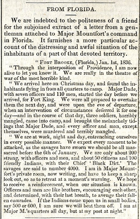
External links
 Definitions from Wiktionary
 Media from Commons
 News from Wikinews
 Quotations from Wikiquote
 Texts from Wikisource
 Textbooks from Wikibooks
 Resources from Wikiversity
![]() Geographic data related to Florida at OpenStreetMap
Geographic data related to Florida at OpenStreetMap
- State website
- Florida at Curlie
- Florida State Guide, from the Library of Congress
- Template:Wikitravel
- Florida Memory Project Over 300,000 photographs and documents from the State Library & Archives of Florida
- Online collection of the Spanish Land Grants.
- USGS real-time, geographic, and other scientific resources of Florida
- University of Florida Digital Collections Digital collections of texts and images, including Florida aerial photography, ephemeral photographs and postcards, letters, and more
- U.S. Census Bureau
- Economic and farm demographics fact sheet from the USDA
- Energy & Environmental Data For Florida
- List of searchable databases produced by Florida state agencies hosted by the American Library Association Government Documents Roundtable
- Heliconius charitonia, zebra longwing Florida state butterfly, on the UF / IFAS Featured Creatures Web site
- Florida stone quarry information on Stone Quarries and Beyond
- “Scenes in Florida,” in Picturesque America, with Illustrations, by Harry Fenn, 1872, on Stone Quarries and Beyond.
- Florida Rivers and Watersheds - Florida DEP
28°8′0″N 81°37′54″W / 28.13333°N 81.63167°W
Related information
Places adjacent to Florida | |
|---|---|