
Bahawalpur: Difference between revisions
No edit summary |
Yamaguchi先生 (talk | contribs) Reverted good faith edits by 39.32.171.94 (talk): Unsourced change. |
||
| Line 7: | Line 7: | ||
{{Infobox settlement |
{{Infobox settlement |
||
|name = Bahawalpur |
|name = Bahawalpur |
||
| |
|other_name = {{Nastaliq|بہاولپور}} {{pa icon}} |
||
|settlement_type = City |
|settlement_type = City |
||
|image_skyline = <!-- Bahawalpur Montage.jpg --> |
|image_skyline = <!-- Bahawalpur Montage.jpg --> |
||
| Line 43: | Line 43: | ||
|area_total_km2 = 237.2 |
|area_total_km2 = 237.2 |
||
|area_metro_km2 = |
|area_metro_km2 = |
||
|population_as_of = |
|population_as_of =1998 |
||
|population_footnotes =<ref name="estimate2006">{{cite web| url=http://www. |
|population_footnotes =<ref name="estimate2006">{{cite web| url=http://www.pbs.gov.pk/sites/default/files//tables/POPULATION%20SIZE%20AND%20GROWTH%20OF%20MAJOR%20CITIES.pdf| title=POPULATION SIZE AND GROWTH OF MAJOR CITIES| first= | last= | accessdate=2015-05-22}}</ref> |
||
|population_note = |
|population_note = |
||
|population_total = |
|population_total =408,395 |
||
|population_density_km2 = |
|population_density_km2 = |
||
|population_urban = |
|population_urban = |
||
|population_density_urban_km2 = |
|population_density_urban_km2 = |
||
|latd=29 |latm=23 |lats=44 |latNS=N |
|latd=29 |latm=23 |lats=44 |latNS=N |
||
| Line 67: | Line 67: | ||
|footnotes = [http://pportal.punjab.gov.pk/portal/portal/media-type/html/group/304?page_name=Bahawalpur$d_home&group_type=dist&group_id=304&group_name=Bahawalpur&js_pane=P-1004ba76975-10000&pview=true Bahawalpur Government Website] |
|footnotes = [http://pportal.punjab.gov.pk/portal/portal/media-type/html/group/304?page_name=Bahawalpur$d_home&group_type=dist&group_id=304&group_name=Bahawalpur&js_pane=P-1004ba76975-10000&pview=true Bahawalpur Government Website] |
||
}} |
}} |
||
'''Bahawalpur''' ([[Punjabi language|Punjabi]], {{lang-ur|{{Nastaliq|بہاولپور}}}}), is a city in [[Pakistan]]. The city is capital of the [[Bahawalpur District]] and is the 11th largest city in Pakistan.<ref>[http://gossip.pk/2015/05/15/bahawalpur-travel-guide-attractions-hotels-restaurants-nightlife-travel-tips/]</ref> |
|||
'''Bahawalpur''' located in [[Punjab, Pakistan|Punjab]], is the [[List of most populated metropolitan areas in Pakistan|11th largest]] city in [[Pakistan]]. In 2007, the city's population was recorded to have risen to 798,509 from 403,408 in 1998.<ref>http://www.bahawalpur.gov.pk/area.htm</ref> The city is capital of [[Bahawalpur District]]. The city was once the capital of the former [[princely state]] and later the province of [[Bahawalpur (princely state)|Bahawalpur]]. The city was home to various [[Nawab]]s (rulers) and counted as part of the [[Rajputana]] states (now [[Rajasthan]], [[India]]). The city is known for its famous palaces such as the [[Noor Mahal]], Sadiq Ghar Palace, and Darbar Mahal, as well as the ancient fort of [[Derawar Fort|Derawar]] in the [[Cholistan Desert]] bordering India. The city is located near the historical and ancient cities of [[Uch]] and [[Harappa]], which were once a stronghold of the [[Delhi Sultanate]] and [[Indus Valley Civilisation]]. The city is home to one of the few natural safari parks in Pakistan, [[Lal Suhanra National Park]]. |
|||
==History== |
==History== |
||
| Line 74: | Line 73: | ||
The [[princely state]] of Bahawalpur was founded in 1802 by Nawab Mohammad Bahawal Khan II after the break-up of the [[Durrani Empire]]. The city is over 4.51 kilometres long. Nawab Mohammad Bahawal Khan III signed a treaty with the [[British India|British]] on 22 February 1833, guaranteeing the independence of the Nawab. The state acceded to Pakistan on 7 October 1947 when Nawab [[Sadeq Mohammad Khan V|Sadiq Muhammad Khan Abbasi V Bahadur]]<ref name="royalark">{{cite web| url=http://www.4dw.net/royalark/Pakistan/bahawal5.htm| title=Bahawalpur: The Abbasi Dynasty| author=Christopher Buyers, Royal Ark website| accessdate=2007-10-13| archiveurl= http://web.archive.org/web/20071115004640/http://www.4dw.net/royalark/Pakistan/bahawal5.htm| archivedate= 15 November 2007 <!--DASHBot-->| deadurl= no}}</ref> decided to join Pakistan at the time of independence. The predominantly Muslim population supported [[All-India Muslim League|Muslim League]] and [[Pakistan Movement]]. After the [[Pakistan Movement|independence]] of [[Pakistan]] in 1947, the minority [[Hindu]]s and [[Sikh]]s [[Human migration|migrated]] to [[India]] while the [[Muslim]]s refugees from [[India]] settled down in the [[Bahawalpur (princely state)|Bahawalpur state]]. Bahawalpur became a province of Pakistan in 1952 and was merged into the province of West Pakistan on 14 October 1955. When West Pakistan was divided into four provinces — [[Sindh]], [[Balochistan (Pakistan)|Balochistan]], [[Khyber Pakhtunkhwa]], and [[Punjab (Pakistan)|Punjab]] — Bahawalpur was amalgamated in [[Punjab (Pakistan)|Punjab]]. |
The [[princely state]] of Bahawalpur was founded in 1802 by Nawab Mohammad Bahawal Khan II after the break-up of the [[Durrani Empire]]. The city is over 4.51 kilometres long. Nawab Mohammad Bahawal Khan III signed a treaty with the [[British India|British]] on 22 February 1833, guaranteeing the independence of the Nawab. The state acceded to Pakistan on 7 October 1947 when Nawab [[Sadeq Mohammad Khan V|Sadiq Muhammad Khan Abbasi V Bahadur]]<ref name="royalark">{{cite web| url=http://www.4dw.net/royalark/Pakistan/bahawal5.htm| title=Bahawalpur: The Abbasi Dynasty| author=Christopher Buyers, Royal Ark website| accessdate=2007-10-13| archiveurl= http://web.archive.org/web/20071115004640/http://www.4dw.net/royalark/Pakistan/bahawal5.htm| archivedate= 15 November 2007 <!--DASHBot-->| deadurl= no}}</ref> decided to join Pakistan at the time of independence. The predominantly Muslim population supported [[All-India Muslim League|Muslim League]] and [[Pakistan Movement]]. After the [[Pakistan Movement|independence]] of [[Pakistan]] in 1947, the minority [[Hindu]]s and [[Sikh]]s [[Human migration|migrated]] to [[India]] while the [[Muslim]]s refugees from [[India]] settled down in the [[Bahawalpur (princely state)|Bahawalpur state]]. Bahawalpur became a province of Pakistan in 1952 and was merged into the province of West Pakistan on 14 October 1955. When West Pakistan was divided into four provinces — [[Sindh]], [[Balochistan (Pakistan)|Balochistan]], [[Khyber Pakhtunkhwa]], and [[Punjab (Pakistan)|Punjab]] — Bahawalpur was amalgamated in [[Punjab (Pakistan)|Punjab]]. |
||
==Geography== |
|||
The city, which lies just south of the [[Sutlej River]], is the site of the Adamwahan Empress Bridge, the only railway bridge over the Sutlej in Pakistan. It is situated 90 km from Multan, 420 km from Lahore, 122 km from [[Burewala]], 90 km from [[Vehari]], 270 km from [[Faisalabad]] and about 700 km from the national capital, [[Islamabad]]. The west region of the city is called the Sindh. It is a fertile alluvial tract in the Sutlej River valley that is irrigated by floodwaters, planted with groves of date palm trees, and thickly populated forests. The chief crops are [[wheat]], [[gram]], [[cotton]], [[sugarcane]], and [[Phoenix dactylifera|dates]].[[Mango]] [[Sheep]] and [[cattle]] are raised for export of [[wool]] and [[hides]]. East of Bahawalpur is the Pat, or Bar, a tract of land considerably higher than the adjoining valley. It is chiefly desert irrigated by the Sutlej inundation canals and yields crops of wheat, cotton, and [[sugarcane]]. Farther east, the [[Cholistan]], is a barren desert tract, bounded on the north and west by the Hakra depression with mound ruins of old settlements along its high banks; it is still inhabited by nomads.{{Citation needed|date=June 2011}} |
|||
===Climate=== |
|||
The climate is mainly hot and dry. In the summer the temperature reaches the high forties (Celsius) during the day and the nights are slightly cooler. Since the city is located in a desert environment there is little rainfall. Weather conditions reach extremes in both summer and winter. The average temperature in summer is {{convert|33|C}} and {{convert|18|C}} in winter. The average rainfall is 20 to 25 cm annually.{{Citation needed|date=June 2011}} |
|||
== Flora and fauna == |
|||
The most commonly seen animals in the city include the hog deer, ravine deer, black buck and blue bull. Fox, jackals, hares, wild boars, porcupines, mongoose, arks, owls and hawks are also found in large numbers. |
|||
==Parks and gardens== |
|||
The [[Bahawalpur Zoo]], is located in Bahawalpur. Spread over an area of several acres inside the city, it contains a variety of animal species, including Asiatic lions, Bengal tigers, hyenas, leopards, and peacocks. The zoo has a collection of 130 animals and 700 birds from tropical regions, particularly those found in the Cholistan region. The zoo occasionally breeds and supplies animals to other zoos in the country. It also has an aquarium and zoological museum with stuffed rare birds and animals. |
|||
Located 35 kilometres east of the city is the [[Lal Suhanra National Park]]housing large animals including lions and rhinoceros. |
|||
==Language== |
|||
[[File:Dialects Of Punjabi.jpg|thumb|right|400px|Dialects of Punjabi]] |
|||
Following are the demographics of the Bahwalpur district, by spoken language: |
|||
* [[Punjabi dialects|Punjab province local people different dialects]]: 96% |
|||
* Other: 4% |
|||
Inhabitants of District speak a great variety of [[Punjabi language|Punjabi]] dialects, although few of these dialects are called as separate language “Saraiki”, but because of good and loving nature of people there is no distinction or hate among different dialects and have a mix culture of Great Bahawalpur State, Punjab and Choolistan. |
|||
*[[Punjabi dialects|Riyasti]] (Local state dialect spoken by 51% population which is a Mix of Rajhastani, Punjabi and Multani(Saraiki) spoken in Tehsils Bahawalpur and Ahmedpur sharqia) |
|||
*[[Majhi dialect|Majhi]] & Malwi (Standard Punjabi dialect spoken by 35% specially in majority in Tehsils Hasilpur, Yazman, Khairpur Tamiwali and sizeable population in cities) |
|||
*[[Rajasthani languages|Bagri]]/Choolistani (9% Population speaks a Punjabi Rajhastani mix specially in Desert area) |
|||
*[[Punjabi dialects|Haryanvi]] (1% population speaks A mixture of Punjabi and Urdu. sizeable population in cities) |
|||
Other Languages include: |
|||
*[[Urdu language|Urdu]] is mother tongue of few people but being national language is spoken and understood by the sizeable population. |
|||
*[[English language|English]] is also understood and spoken by the educated elite. |
|||
*[[Balochi language|Balochi]] is also spoken by small population. |
|||
==Economy== |
==Economy== |
||
| ⚫ | |||
[[File:Hasilpur Bahawal Canal.jpg|thumb|Irrigation from canals such as this provides the city with fertile soil for crop production.]] |
[[File:Hasilpur Bahawal Canal.jpg|thumb|Irrigation from canals such as this provides the city with fertile soil for crop production.]] |
||
The main crops for which Bahawalpur is recognised are [[cotton]], [[sugarcane]], [[wheat]], [[sunflower seed]]s, [[rapeseed|rape]]/[[mustard seed]] and [[rice]]. Bahawalpur [[mangoes]], citrus, [[Phoenix dactylifera|dates]] and [[guavas]] are some of the fruits exported out of the country. Vegetables include [[onion]]s, [[tomato]]es, [[cauliflower]], [[potato]]es and [[carrot]]s. Being an expanding industrial city, the government has revolutionised and libertised various markets, allowing the caustic soda, cotton ginning and pressing, flour mills, fruit juices, general engineering, iron and steel re-rolling mills, looms, oil mills, poultry feed, sugar, textile spinning, textile weaving, vegetable ghee and cooking oil industries to flourish.<ref>http://pportal.punjab.gov.pk/portal/portal/media-type/html/group/304/page/default.psml/js_pane/P-11aeca7c599-100e5?nav=left</ref> |
The main crops for which Bahawalpur is recognised are [[cotton]], [[sugarcane]], [[wheat]], [[sunflower seed]]s, [[rapeseed|rape]]/[[mustard seed]] and [[rice]]. Bahawalpur [[mangoes]], citrus, [[Phoenix dactylifera|dates]] and [[guavas]] are some of the fruits exported out of the country. Vegetables include [[onion]]s, [[tomato]]es, [[cauliflower]], [[potato]]es and [[carrot]]s. Being an expanding industrial city, the government has revolutionised and libertised various markets, allowing the caustic soda, cotton ginning and pressing, flour mills, fruit juices, general engineering, iron and steel re-rolling mills, looms, oil mills, poultry feed, sugar, textile spinning, textile weaving, vegetable ghee and cooking oil industries to flourish.<ref>http://pportal.punjab.gov.pk/portal/portal/media-type/html/group/304/page/default.psml/js_pane/P-11aeca7c599-100e5?nav=left</ref> |
||
Bahawalpur lies at the junction of trade routes from the east, south-east, and south. It is a center for trade in wheat, cotton, millet, and rice grown in the surrounding region. Dates and mangoes are also grown here. Canals supply water for irrigation. The principal industries are cotton ginning, rice and flour milling, and the hand weaving of textiles. |
|||
Soap making and cotton ginning are important enterprises; cotton, silk, embroidery, carpets, and extraordinarily delicate pottery are produced. Factories producing cottonseed oil and cottonseed cake were built in the 1970s. It is an important marketing center for the surrounding areas and is located on the crossroads between Peshawar, Lahore, Quetta and Karachi. Bahawalpur is also known for its distinctively embroidered slippers and shoes and filigree pottery. |
|||
Bahawalpur has only one railway bridge, the Adamwahan (Empress) Bridge, over the Sutlej River, and also has rail links with [[Peshawar]], the capital of [[Khyber Pakhtunkhwa]] and [[Karachi]], the capital of [[Sindh]] (which is 899 km from Bahawalpur), making it an important rail centre. The surrounding area is mostly agricultural, which allows agricultural exports to many parts of the world. There is also a large market town for mangoes, dates, wheat, sugarcane, and cotton that brings in continuous demand all year round. It has soap making and cotton spinning factories, as well as enterprises producing silk and cotton textiles, carpets, and pottery. Bahwalpur has sugar mills that provide some of the export market out of the country. According to PSMA (Pakistan Sugar Mills Association) about 22% of Pakistan's sugar is produced in Bahawalpur division (including [[Bahawalnagar]] and [[Rahim Yar Khan]]). |
|||
[[Punjab (Pakistan)|Punjab]] is Pakistan's most fertile province, rich in both agriculture and ancient history. It is also one of the more stable of the country's regions. The prosperous and hospitable town of Bahawalpur is a gentle introduction to the area, which makes the city an ideal tourist destination. From here one can journey into Cholistan – a sandy wasteland dotted with nomadic communities and windswept forts – or the [[Lal Suhanra National Park]], an important wildlife reserve. Further north is [[Harappa]], which is an important site of the [[Indus Valley Civilization]]. Bahawalpur is the most southerly town in the Punjab. There are daily flights from Islamabad about 555 km (344 mi) away. Most of the major destinations in the Punjab can be reached by car, bus, coach, and train. |
|||
There is a newly built trade centre in bahawalpur called "bahawalpur trade centre". It has 5 flours and many shops. There are two mobile plazas in bahawalpur(ALKAREEM PLAZA and DUBAI PLAZA). |
|||
==Culture== |
|||
| ⚫ | |||
The city of Bahawalpur has a rich heritage and is an important hot spot for historians as well as archaeologists. Bahawalpur is known for its cotton, silk, embroidery, carpets, and extraordinarily delicate pottery. The Punjab Small Industries Corporation (PSIC) has established a Craft Development Center for Cholistan area, outside Farid Gate, Bahawalpur from where handicrafts manufactured in Cholistan can be purchased. Some of the souvenirs produced in the city include: |
|||
* Flassi – 4 ft by 7 ft, made of camel hair and cotton yarn; it is used for wall hanging, as a decoration piece and a carpet. |
|||
* Gindi or Rilli – Made of small pieces of many colors of cotton cloth and needlework; they can be used as wall hangings, bed covers, carpets and blankets. |
|||
* Changaries – Like big plaques, these are made of palm leaves in different bright colours with beautiful patterns and geometric designs. These are used for keeping the 'chapattis' and also as a wall decoration. |
|||
* Khalti – Like a purse embroidered on top with multicoloured threads. |
|||
* Artwork – An attractive type of embroidery done on dupatta, kurta and chaddar, etc. |
|||
The main shopping centers of Bahawalpur are Shahi Bazaar, Machli Bazaar, Farid Gate and the Mall. The commercial area in Satellite Town is a newly developed center that is gaining popularity. A few shopping malls, including Bobby Plaza, Takbeer Shopping Mall, Time, and Prince, cater for all kinds of needs. Shopping is a major attraction in the city; the city is bustling with traders and craftsmen selling all sorts of artwork for travellers and tourists. |
|||
| ⚫ | |||
East of Bahawalpur is the [[Cholistan Desert]], which covers an area of about 15,000 km<sup>2</sup> and extends into the [[Thar Desert]] of [[India]]. The region was once watered by the [[Hakra River]], known as the Saravati in [[vedic]] times. At one time there were 400 forts in the area and archaeological finds around the [[Derawar Fort]], the only place with a perennial waterhole, indicate that it was contemporaneous with the [[Indus Valley Civilisation]]. The average annual rainfall is only 12 cm, and the area's scant cultivation is made possible by underground wells, drawn up by camels. The water is stored in troughs, built by the tribes, between sandhills and din waterholes called tobas. The people are racially similar to those in Rajasthan – tall, with sharp features. They live in large, round, mud and grass huts, usually built on the top of sandhills. On the whole, they are pastoral and nomadic. The main tribes are the Chachar, Mehr, Lar, Paryar, Channar, Chandani and Bohar. The forts here were built at 29 km intervals, which probably served as guard posts for the camel caravan routes. There were three rows of these forts. The first line of forts began from Phulra and ended in Lera, the second from Rukhanpur to Islamgarh, and the third from Bilcaner to Kapoo. Built with double walls of gypsum blocks and mud, they are all in ruins now. Some of them date back to 1000 BC, and were destroyed and rebuilt many times. |
|||
Even with all the markets and forts, one thing for which Bahawalpur is recognised above all others is the numerous palaces that still remain intact ever since the fall of the Nawabs. There are countless palaces in the city, locally known as Mahals. Some of the most famous include: [[Noor Mahal]], Gulzar Mahal, Darbar Mahal, Shimla Khoti Sadiq Ghar Palace and Darbar Mahal. The city also has a city gate called Farid Gate, which in its heyday provided the only entrance to the city for its rulers. The gate still remains and is now located in a busy market in the inner city. The [[Bahawalpur Museum]] and [[Bahawalpur National Library]] house various collections of coins, medals, postage stamps of the former state of Bahawalpur, manuscripts, documents, inscriptions, wood carvings, camel skin paintings, historical models and stone carvings from Islamic and pre-Islamic eras. There is a complete set of medals of all classes issued by the ex-state to its military officers, civilians, and other important citizens of the ex-state. |
|||
The city also has several mausoleums of prominent leaders who fought and defended the region over several thousands of years. Some of the most prolific include the tombs of Channen Peer Tomb Yazman and Mausoleums of Haugha Sahib. There is also an old fort of Munde Shahid, 50 km from Bahawalpur and [[Marot Fort]], which are considered to be antiquities. A place outside the Marot Fort is known as 'Baithak Maula Ali'. The tomb of Naugaza is located in the Munde Sharif Fort. |
|||
==Education== |
==Education== |
||
===Public schools=== |
===Public schools=== |
||
| ⚫ | |||
[[File:sadiq public school almaktoum library.jpg|thumb|Al-Maktoum Library]] |
[[File:sadiq public school almaktoum library.jpg|thumb|Al-Maktoum Library]] |
||
| ⚫ | |||
===Private schools===<!-- PLEASE RESPECT ALPHABETICAL ORDER --> |
|||
===Private schools=== |
|||
<!-- Please cite a valid source for any changes to this list --> |
|||
{{Div col}} |
{{Div col}} |
||
*[[Army Public Schools & Colleges System|Army Public School]] |
*[[Army Public Schools & Colleges System|Army Public School]] |
||
| Line 155: | Line 93: | ||
*[[Jinnah Public School]] |
*[[Jinnah Public School]] |
||
*[[The City School (Pakistan)|The City School]] |
*[[The City School (Pakistan)|The City School]] |
||
{{Div col end}} |
{{Div col end}} |
||
| Line 161: | Line 100: | ||
==Sports== |
==Sports== |
||
[[Bahawal Stadium]] |
[[Bahawal Stadium]] is the multipurpose stadium, home to domestic cricket team [[Bahawalpur Stags]]. [[Test cricket|Test match]]es and [[One Day International]]s are hosted at the stadium. |
||
There are many regional games played in modern city, like gilli danda, wahnju(typically identical to rugby),bander qilla and many other.There is also a jeep rally arranged by government near derawar fort. In which many race lovers from all over country participate |
|||
==Transportation== |
|||
Bahawalpur is well connected with various cities in Pakistan. The city has its own airport built by the [[Department of Civil Aviation (Dubai)|Dubai Civil Aviation Department]] and the [[Civil Aviation Authority of Pakistan|CAA]]. [[Bahawalpur Airport]] links the city with various Pakistani cities such as Dera Ghazi Khan, Islamabad, Karachi and Lahore with the national flag carrier, [[Pakistan International Airlines]]. The airline has launched international flights to Dubai, and plans to introduce more international destinations. There are daily train and bus services from Multan, Lahore, Sukkur and Karachi to Bahawalpur.[[taxicabs]] and [[Auto rickshaw|rickshaws]] are plentiful in the city. Cars are also available for hire in the city. |
|||
==Notable people== |
==Notable people== |
||
| Line 173: | Line 108: | ||
{{cleanup-gallery|section|date=January 2012}} |
{{cleanup-gallery|section|date=January 2012}} |
||
<gallery> |
<gallery> |
||
| ⚫ | |||
| ⚫ | |||
| ⚫ | |||
Image:BahawalpurDaewoo.JPG|Daewoo Terminal, Bahawalpur |
Image:BahawalpurDaewoo.JPG|Daewoo Terminal, Bahawalpur |
||
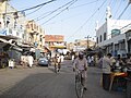
Image:Bahawalpurinsidefarid.JPG|Market Inside Farid Gate |
Image:Bahawalpurinsidefarid.JPG|Market Inside Farid Gate |
||
| Line 189: | Line 127: | ||
* [[Kakazai]] |
* [[Kakazai]] |
||
* [[Noor Mahal]] |
* [[Noor Mahal]] |
||
<!-- * [[Sadiq Public SchoolBahawalpur|Sadiq Public School]] --> |
|||
* [[Islamia University|The Islamia University of Bahawalpur]] |
|||
* [[Quaid-e-Azam Medical College]] |
|||
== References == |
== References == |
||
Revision as of 17:51, 26 May 2015
This article has multiple issues. Please help improve it or discuss these issues on the talk page. (Learn how and when to remove these template messages)
|
Bahawalpur
بہاولپور Template:Pa icon | |
|---|---|
City | |
| Country | Pakistan |
| Region | Punjab |
| District | Bahawalpur District |
| Tehsil | Bahawalpur Tehsil |
| Union councils | 36 |
| Government | |
| • Nazim | ---------------- |
| Area | |
| • Total | 237.2 km2 (91.6 sq mi) |
| Elevation | 461 m (1,512 ft) |
| Population (1998)[3] | |
| • Total | 408,395 |
| Time zone | UTC+5 (PST) |
| • Summer (DST) | UTC+6 (PDT) |
| Postal code type | 63100 |
| Area code | 062 |
| Website | www.bahawalpur.gov.pk/ |
| Bahawalpur Government Website | |
Bahawalpur (Punjabi, Urdu: بہاولپور), is a city in Pakistan. The city is capital of the Bahawalpur District and is the 11th largest city in Pakistan.[4]
History
The princely state of Bahawalpur was founded in 1802 by Nawab Mohammad Bahawal Khan II after the break-up of the Durrani Empire. The city is over 4.51 kilometres long. Nawab Mohammad Bahawal Khan III signed a treaty with the British on 22 February 1833, guaranteeing the independence of the Nawab. The state acceded to Pakistan on 7 October 1947 when Nawab Sadiq Muhammad Khan Abbasi V Bahadur[5] decided to join Pakistan at the time of independence. The predominantly Muslim population supported Muslim League and Pakistan Movement. After the independence of Pakistan in 1947, the minority Hindus and Sikhs migrated to India while the Muslims refugees from India settled down in the Bahawalpur state. Bahawalpur became a province of Pakistan in 1952 and was merged into the province of West Pakistan on 14 October 1955. When West Pakistan was divided into four provinces — Sindh, Balochistan, Khyber Pakhtunkhwa, and Punjab — Bahawalpur was amalgamated in Punjab.
Economy

The main crops for which Bahawalpur is recognised are cotton, sugarcane, wheat, sunflower seeds, rape/mustard seed and rice. Bahawalpur mangoes, citrus, dates and guavas are some of the fruits exported out of the country. Vegetables include onions, tomatoes, cauliflower, potatoes and carrots. Being an expanding industrial city, the government has revolutionised and libertised various markets, allowing the caustic soda, cotton ginning and pressing, flour mills, fruit juices, general engineering, iron and steel re-rolling mills, looms, oil mills, poultry feed, sugar, textile spinning, textile weaving, vegetable ghee and cooking oil industries to flourish.[6]
Education
Public schools

The city is served by Sadiq Public School.
Private schools
Colleges and universities
Bahawalpur is home to The Islamia University of Bahawalpur, Quaid-e-Azam Medical College, and Allama Iqbal College of Commerce.
Sports
Bahawal Stadium is the multipurpose stadium, home to domestic cricket team Bahawalpur Stags. Test matches and One Day Internationals are hosted at the stadium.
Notable people
Gallery
This section contains an unencyclopedic or excessive gallery of images. |
-
 Derawar Fort is on the outskirts of the city in the Cholistan Desert
 -
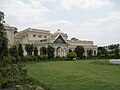
 Noor Mahal lit at night after being newly renovated
 -
 Darbar Mahal, a former palace of the Nawabs of Bahawalpur
 -
 Daewoo Terminal, Bahawalpur
 -
 Market Inside Farid Gate
 -
 Farid Gate, Bahawalpur
 -
 Noor Mahal
 -
 Sadiq Dane High School, Bahawalpur
 -
 Entrance of Dring Stadium
 -
 Bahawal Victoria Hospital
 -
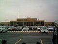 Sheikh Rashid Air Terminal, Bahawalpur Airport


See also
References
- ^ a b http://203.215.180.58/portal/portal/media-type/html/group/320/page/default.psml/js_pane/P-103d7b410be-10000?nav=left
- ^ http://www.statpak.gov.pk/depts/pco/index.html
- ^ "POPULATION SIZE AND GROWTH OF MAJOR CITIES" (PDF). Retrieved 22 May 2015.
- ^ [1]
- ^ Christopher Buyers, Royal Ark website. "Bahawalpur: The Abbasi Dynasty". Archived from the original on 15 November 2007. Retrieved 13 October 2007.
{{cite web}}: Unknown parameter|deadurl=ignored (|url-status=suggested) (help) - ^ http://pportal.punjab.gov.pk/portal/portal/media-type/html/group/304/page/default.psml/js_pane/P-11aeca7c599-100e5?nav=left
External links
 Definitions from Wiktionary
 Media from Commons
 News from Wikinews
 Quotations from Wikiquote
 Texts from Wikisource
 Textbooks from Wikibooks
 Resources from Wikiversity
- Official website
 Bahawalpur travel guide from Wikivoyage
- Bahawalpur at Curlie
Neighbourhoods of Bahawalpur | ||
|---|---|---|
Administrations: Bahawalpur Division and Bahawalpur District | ||
| Tehsils |  | |
| Cities | ||
| Towns and councils | ||
| Villages | ||
Website: Bahawalpur District at NRB | ||
Pakistan articles | |||||||||||||||||||
|---|---|---|---|---|---|---|---|---|---|---|---|---|---|---|---|---|---|---|---|
| |||||||||||||||||||
| |||||||||||||||||||
| |||||||||||||||||||
| |||||||||||||||||||
| |||||||||||||||||||