
List of cities in Uttar Pradesh by population: Difference between revisions
Tags: Mobile edit Mobile web edit Advanced mobile edit |
No edit summary Tags: Mobile edit Mobile web edit Advanced mobile edit |
||
| Line 23: | Line 23: | ||
}} |
}} |
||
The Indian [[States and union territories of India|state]] of [[Uttar Pradesh]] borders with [[Nepal]] and the Indian states of [[Bihar]], [[Jharkhand]], [[Chhattisgarh]], [[Madhya Pradesh]], [[Rajasthan]], [[Haryana]], [[Uttarakhand]], [[Himachal Pradesh]] and [[National Capital Territory of Delhi]]. The [[Himalayas]] lies in the north of the state and the [[Deccan Plateau]] is at the south. In between them, the river [[Ganges]], [[Yamuna]] and [[Sarayu]] flow eastwards. Uttar Pradesh can be divided into two distinct regions, Southern hills and Gangetic plain. Uttar Pradesh is divided into 75 [[Districts of Uttar Pradesh|districts]] under 18 [[Divisions of Uttar Pradesh|divisions]].<ref name=divisions>{{cite web|title=State division of Uttar Pradesh|url=http://india.gov.in/knowindia/districts/andhra1.php?stateid=UP|publisher= Government of India|accessdate=22 July 2012}}</ref> As of 2011, with an estimated population of 199,581,477. Uttar Pradesh is the [[List of states and union territories of India by population|most populous state]] in India.<ref name=mostpopulous>{{cite web|title=Uttar Pradesh Population 2011|url=http://www.census2011.co.in/census/state/uttar+pradesh.html|work=Government of India|publisher=[[2011 Census of India]]|accessdate=8 October 2012}}</ref> Uttar Pradesh occupies 6.88 percent of the India's land surface area but is home to 16.49 percent of the India's population.<ref name="States and UT %">{{cite web|url=http://www.censusindia.gov.in/Data_Products/Library/Provisional_Population_Total_link/PDF_Links/chapter3.pdf|title=Ranking of States and Union territories by population size : 1991 and 2001|work=Government of India (2001)|publisher=Census of India|pages=5–6|accessdate=12 December 2008}}</ref><ref name=census>{{cite web|title=Size, Growth rate and population distribution|url=http://www.censusindia.gov.in/Data_Products/Library/Provisional_Population_Total_link/PDF_Links/chapter3.pdf|work=Government of India|publisher=[[2011 Census of India]]|accessdate=8 October 2012}}</ref> As of 2011, 64 cities in the state had a population of over 100,000 people. [[Kanpur]] is the largest city of Uttar Pradesh with {{convert|1,640|km2|sqmi}} area having an approximate population of over 3 million which comes under [[Kanpur metropolitan area]]. It is also the most literate city of Uttar Pradesh with 88.98 literacy rate.<ref name=ProvisionalPopulation/> The smallest city with a population over 100,000 people was [[Kakrala]] in [[Badaun district]] with a population of 100,080 people according to 2011 census figures. |
The Indian [[States and union territories of India|state]] of [[Uttar Pradesh]] borders with [[Nepal]] and the Indian states of [[Bihar]], [[Jharkhand]], [[Chhattisgarh]], [[Madhya Pradesh]], [[Rajasthan]], [[Haryana]], [[Uttarakhand]], [[Himachal Pradesh]] and [[National Capital Territory of Delhi]]. The [[Himalayas]] lies in the north of the state and the [[Deccan Plateau]] is at the south. In between them, the river [[Ganges]], [[Yamuna]] and [[Sarayu]] flow eastwards. Uttar Pradesh can be divided into two distinct regions, Southern hills and Gangetic plain. Uttar Pradesh is divided into 75 [[Districts of Uttar Pradesh|districts]] under 18 [[Divisions of Uttar Pradesh|divisions]].<ref name=divisions>{{cite web|title=State division of Uttar Pradesh|url=http://india.gov.in/knowindia/districts/andhra1.php?stateid=UP|publisher= Government of India|accessdate=22 July 2012}}</ref> As of 2011, with an estimated population of 199,581,477. Uttar Pradesh is the [[List of states and union territories of India by population|most populous state]] in India.<ref name=mostpopulous>{{cite web|title=Uttar Pradesh Population 2011|url=http://www.census2011.co.in/census/state/uttar+pradesh.html|work=Government of India|publisher=[[2011 Census of India]]|accessdate=8 October 2012}}</ref> Uttar Pradesh occupies 6.88 percent of the India's land surface area but is home to 16.49 percent of the India's population.<ref name="States and UT %">{{cite web|url=http://www.censusindia.gov.in/Data_Products/Library/Provisional_Population_Total_link/PDF_Links/chapter3.pdf|title=Ranking of States and Union territories by population size : 1991 and 2001|work=Government of India (2001)|publisher=Census of India|pages=5–6|accessdate=12 December 2008}}</ref><ref name=census>{{cite web|title=Size, Growth rate and population distribution|url=http://www.censusindia.gov.in/Data_Products/Library/Provisional_Population_Total_link/PDF_Links/chapter3.pdf|work=Government of India|publisher=[[2011 Census of India]]|accessdate=8 October 2012}}</ref> As of 2011, 64 cities in the state had a population of over 100,000 people. [[Kanpur]] is the largest city of Uttar Pradesh with {{convert|1,640|km2|sqmi}} area having an approximate population of over 3 million which comes under [[Kanpur metropolitan area]]. It is also the most literate city of Uttar Pradesh with 88.98 literacy rate.<ref name=ProvisionalPopulation/> The smallest city with a population over 100,000 people was [[Kakrala]] in [[Badaun district]] with a population of 100,080 people according to 2011 census figures. |
||
==Census of Uttar Pradesh== |
|||
The census in India is conducted by the Office of the [[Registrar General and Census Commissioner of India|Registrar General and Census Commissioner]] under the [[Ministry of Home Affairs (India)|Ministry of Home Affairs]], and is one of the largest administrative tasks conducted by a federal government.<ref name="Brief history of census">{{cite web |
|||
|url=http://www.censusindia.gov.in/Census_And_You/brief_history_of_census.aspx|title=Brief history of census |
|||
|work=Government of India (2001) |
|||
|publisher=Census of IngfswerthCjsgkwfkwjwtjtdia |
|||
|accessdate=26 October 2008}}</ref> The latest population figures are based on data from the [[2011 census of India]]. Uttar Pradesh has both a large population and a high population growth rate.<ref name=ProvisionalPopulation/> During the decade from 1991 to 2001 its population increased by over 17.8%.<ref name=ProvisionalPopulation>{{cite web|title=Provisional Population Totals|url=http://censusindia.gov.in/2011-prov-results/prov_data_products_up.html|work=Government of India|publisher=[[2011 Census of India]]|accessdate=8 October 2012}}</ref> |
|||
The state's 2001–2011 decennial growth rate (including Uttrakhand) was 20.09%, higher than 1991–2001 rate of 17.8% and also higher than the national rate of 17.64%.<ref name=Decennial>{{cite web|title=Decennil growth of population by census|url=http://www.cwc.nic.in/Water_Data_Pocket_Book_2006/t9.01final.pdf|work=Government of India|publisher=Census of India (2011)|accessdate=5 October 2012}}</ref> As of the 2001 Indian census, about 80% of Uttar Pradesh's population is Hindu, while Muslims make up around 18.4% of the population. The population density is 828 people per square kilometre, making it one of the densest states in the country.<ref name=ProvisionalPopulation/> The sex ratio as of 2011, at 908 women to 1000 men, is lower than the national figure of 940. Uttar Pradesh has the existing of the caste system among the [[Hindus]] who constitute vast variety of population.{{Citation needed|date=September 2015}} |
|||
The high population of state have resulted in the growth of large settlements caste in compact regions in Uttar Pradesh, it includes[[Brahmin]], [[Ahirs]], [[Kurmis]] and [[Bhumihar]]s. [[Scheduled castes]] and [[Harijans]] who also exist in state.{{Citation needed|date=September 2015}} Because of both a large population and a high population growth rate, Uttar Pradesh figure among the list of states with large number of people living below [[Poverty threshold|poverty line]].<ref name=poverty/> The latest estimates released by the Planning Commission for the year 2004-05 reveals that Uttar Pradesh has the largest BPL population, with 59 million people living below the [[Below Poverty Line (India)|poverty line]].<ref name=poverty>{{cite web|title=The state with large no. of people living below poverty line|url=http://pib.nic.in/newsite/erelease.aspx?relid=49731|work=Government of India|publisher=''Press Information Bureau|accessdate=5 October 2012}}</ref> |
|||
==List== |
==List== |
||
Revision as of 15:08, 4 January 2020

The Indian state of Uttar Pradesh borders with Nepal and the Indian states of Bihar, Jharkhand, Chhattisgarh, Madhya Pradesh, Rajasthan, Haryana, Uttarakhand, Himachal Pradesh and National Capital Territory of Delhi. The Himalayas lies in the north of the state and the Deccan Plateau is at the south. In between them, the river Ganges, Yamuna and Sarayu flow eastwards. Uttar Pradesh can be divided into two distinct regions, Southern hills and Gangetic plain. Uttar Pradesh is divided into 75 districts under 18 divisions.[1] As of 2011, with an estimated population of 199,581,477. Uttar Pradesh is the most populous state in India.[2] Uttar Pradesh occupies 6.88 percent of the India's land surface area but is home to 16.49 percent of the India's population.[3][4] As of 2011, 64 cities in the state had a population of over 100,000 people. Kanpur is the largest city of Uttar Pradesh with 1,640 square kilometres (630 sq mi) area having an approximate population of over 3 million which comes under Kanpur metropolitan area. It is also the most literate city of Uttar Pradesh with 88.98 literacy rate.[5] The smallest city with a population over 100,000 people was Kakrala in Badaun district with a population of 100,080 people according to 2011 census figures.
List
This list refers only to the population of individual municipalities within their defined limits; the populations of other municipalities considered suburbs or outgrowths of a central city are listed separately, and unincorporated areas within urban agglomerations are not included. Therefore, a different ranking is evident when considering metropolitan area population of Uttar Pradesh.
The total geographical area of Uttar Pradesh is 240,928 square kilometres (93,023 sq mi).[2] As per census data 2011, the total population of Uttar Pradesh is: 199,581,477.[2]
| Rank | Name | District | Type* | Category | Population 2011[6][7] | Male[8] | Female[8] | Population below 5 yrs[8] |
Literacy Rate[8] | ||||||||||||||||||||
|---|---|---|---|---|---|---|---|---|---|---|---|---|---|---|---|---|---|---|---|---|---|---|---|---|---|---|---|---|---|
| 1 | Lucknow | Lucknow | UA | Nagar Nigam | 2,817,105 | 1,484,967 | 1,474,100 | 266,336 | 88.98 | ||||||||||||||||||||
| 2 | Kanpur | Kanpur | UA | Nagar Nigam | 2,767,348 | 1,618,951 | 1,582,523 | 289,375 | 84.72 | ||||||||||||||||||||
| 3 | Ghaziabad | Ghaziabad | UA | Nagar Nigam | 2,358,525 | 1,256,783 | 1,202,742 | 308,717 | 84.78 | ||||||||||||||||||||
| 4 | Agra | Agra | UA | Nagar Nigam | 1,585,704 | 1,042,441 | 963,402 | 210,036 | 64.61 | ||||||||||||||||||||
| 5 | Allahabad | Allahabad | UA | Nagar Nigam | 1,540,544 | 961,060 | 874,053 | 157,482 | 80.31 | ||||||||||||||||||||
| 6 | Meerut | Meerut | UA | Nagar Nigam | 1,226,709 | 6,54,857 | 5,70,051 | 176,770 | 78.29 | ||||||||||||||||||||
| 7 | Varanasi | Varanasi | UA | Nagar Nigam | 1,201,815 | 755,734 | 660,985 | 112,023 | 86.06 | ||||||||||||||||||||
| 8 | Bareilly | Bareilly | UA | Nagar Nigam | 903,668 | 722,385 | 557,548 | 104,560 | 70.97 | ||||||||||||||||||||
| 9 | Aligarh | Aligarh | UA | Nagar Nigam | 909,559 | 482,828 | 426,731 | 118,778 | 70.54 | ||||||||||||||||||||
| 10 | Moradabad | Moradabad | City | Nagar Nigam | 889,810 | 466,432 | 432,378 | 110,376 | 70.65 | ||||||||||||||||||||
| 11 | Saharanpur | Saharanpur | City | Nagar Nigam | 703,345 | 371,858 | 331,487 | 88,501 | 77.94 | ||||||||||||||||||||
| 12 | Gorakhpur | Gorakhpur | UA | Nagar Nigam | 692,519 | 365,148 | 327,371 | 65,078 | 85.64 | ||||||||||||||||||||
| 13 | Ayodhya | Ayodhya | UA | Nagar Nigam | 642,381 | 320,482 | 321,899 | 63,567 | 88.58 | ||||||||||||||||||||
| 14 | Firozabad | Firozabad | City | Nagar Nigam | 603,797 | 320,012 | 283,785 | 83,530 | 75.01 | ||||||||||||||||||||
| 15 | Jhansi | Jhansi | UA | Nagar Nigam | 549,391 | 292,497 | 256,894 | 56,230 | 84.41 | ||||||||||||||||||||
| 16 | Muzaffarnagar | Muzaffarnagar | City | Nagar Palika | 494,792 | 261,338 | 233,454 | 64,696 | 80.99 | ||||||||||||||||||||
| 17 | Mathura | Mathura | UA | Nagar Nigam | 454,937 | 244,333 | 210,604 | 56,267 | 77.11 | ||||||||||||||||||||
| 18 | Budaun | Budaun | UA | Nagar Palika | 369,221 | 188,475 | 179,746 | 42,613 | 83.00 | ||||||||||||||||||||
| 19 | Rampur | Rampur | UA | Nagar Palika | 359,062 | 182,325 | 166,737 | 41,769 | 79.56 | ||||||||||||||||||||
| 20 | Shahjahanpur | Shahjahanpur | UA | Nagar Nigam | 356,103 | 183,087 | 163,016 | 38,736 | 79.81 | ||||||||||||||||||||
| 21 | Farrukhabad-cum-Fategarh | Farrukhabad | UA | Nagar Palika | 318,540 | 164,630 | 145,910 | 39,944 | 75.60 | ||||||||||||||||||||
| 22 | Ayodhya Cantt | Ayodhya | UA | Nagar Palika | 290,799 | 140,799 | 150,000 | 25,789 | 93.89 | ||||||||||||||||||||
| 23 | Maunath Bhanjan | Mau | City | Nagar Palika | 279,060 | 143,273 | 135,787 | 40,651 | 78.60 | ||||||||||||||||||||
| 24 | Hapur | Hapur | City | Nagar Palika | 262,801 | 139,694 | 123,107 | 36,714 | 75.34 | ||||||||||||||||||||
| 25 | Noida | Gautam Buddh Nagar | City | Notified Area | 259,160 | 139,074 | 120,086 | 25,436 | 88.58 | ||||||||||||||||||||
| 26 | Etawah | Etawah | City | Nagar Palika | 256,790 | 135,829 | 120,961 | 28,922 | 82.89 | ||||||||||||||||||||
| 27 | Mirzapur-cum-Vindhyachal | Mirzapur | UA | Nagar Palika | 245,817 | 131,534 | 114,283 | 29,619 | 77.85 | ||||||||||||||||||||
| 28 | Bulandshahr | Bulandshahr | UA | Nagar Palika | 235,310 | 125,549 | 111,761 | 30,886 | 78.37 | ||||||||||||||||||||
| 29 | Sambhal | Sambhal | City | Nagar Palika | 221,334 | 116,008 | 105,326 | 34,279 | 49.51 | ||||||||||||||||||||
| 30 | Amroha | Amroha | City | Nagar Palika | 197,135 | 102,804 | 94,331 | 26,855 | 63.88 | ||||||||||||||||||||
| 31 | Hardoi | Hardoi | UA | Nagar Palika | 197,046 | 104,201 | 92,845 | 21,719 | 83.27 | ||||||||||||||||||||
| 32 | Fatehpur | Fatehpur | City | Nagar Palika | 193,801 | 101,620 | 92,181 | 22,078 | 77.69 | ||||||||||||||||||||
| 33 | Raebareli | Raebareli | City | Nagar Palika | 191,625 | 99,844 | 91,212 | 18,866 | 82.97 | ||||||||||||||||||||
| 34 | Orai | Jalaun | UA | Nagar Palika | 190,625 | 101,434 | 89,191 | 20,424 | 83.35 | ||||||||||||||||||||
| 35 | Sitapur | Sitapur | UA | Nagar Palika | 188,230 | 99,129 | 89,101 | 19,721 | 83.02 | ||||||||||||||||||||
| 36 | Bahraich | Bahraich | City | Nagar Palika | 186,241 | 98,529 | 87,712 | 22,828 | 75.3 | ||||||||||||||||||||
| 37 | Modinagar | Ghaziabad | UA | Nagar Palika | 182,811 | 97,335 | 85,476 | 21,441 | 87.03 | ||||||||||||||||||||
| 38 | Unnao | Unnao | City | Nagar Palika | 178,681 | 94,080 | 84,601 | 18,604 | 83.72 | ||||||||||||||||||||
| 39 | Jaunpur | Jaunpur | City | Nagar Palika | 168,128 | 88,704 | 79,424 | 18,033 | 82.11 | ||||||||||||||||||||
| 40 | Lakhimpur | Lakhimpur Kheri | UA | Nagar Palika | 164,925 | 88,908 | 77,017 | 18,174 | 83.80 | ||||||||||||||||||||
| 41 | Hathras | Hathras | UA | Nagar Palika | 161,289 | 86,028 | 75,261 | 20,279 | 78.05 | ||||||||||||||||||||
| 42 | Banda | Banda | UA | Nagar Palika | 160,432 | 85,473 | 74,959 | 18,317 | 83.61 | ||||||||||||||||||||
| 43 | Pilibhit | Pilibhit | UA | Nagar Palika | 160,146 | 84,546 | 75,600 | 16,089 | 72.30 | ||||||||||||||||||||
| 44 | Deen Dayal upadhayay | Chandauli | UA | Nagar Palika | 154,692 | 81,524 | 73,168 | 19,055 | 78.08 | ||||||||||||||||||||
| 45 | Barabanki | Barabanki | UA | Nagar Palika | 154,692 | 77,766 | 69,065 | 16,093 | 81.15 | ||||||||||||||||||||
| 46 | Khurja | Bulandshahr | UA | Nagar Palika | 142,636 | 75,384 | 67,252 | 20,072 | 72.75 | ||||||||||||||||||||
| 47 | Gonda | Gonda | UA | Nagar Palika | 200000 | 71,475 | 67,454 | 15,608 | 80.32 | ||||||||||||||||||||
| 48 | Mainpuri | Mainpuri | UA | Nagar Palika | 133,078 | 69,788 | 63,290 | 16,371 | 85.66 | ||||||||||||||||||||
| 49 | Lalitpur | Lalitpur | City | Nagar Palika | 133,041 | 69,548 | 63,493 | 16,193 | 83.96 | ||||||||||||||||||||
| 50 | Etah | Etah | UA | Nagar Palika | 131,023 | 69,446 | 61,577 | 15,890 | 85.62 | ||||||||||||||||||||
| 51 | Deoria | Deoria | City | Nagar Palika | 129,570 | 67,754 | 61,816 | 13,821 | 93.73 | ||||||||||||||||||||
| 52 | Ujhani | Budaun | UA | Nagar Palika | 126,000 | 64,000 | 62,000 | 17,613 | 87.00 | ||||||||||||||||||||
| 53 | Ghazipur | Ghazipur | UA | Nagar Palika | 121,136 | 63,689 | 57,447 | 13,986 | 84.97 | ||||||||||||||||||||
| 54 | Sultanpur | Sultanpur | UA | Nagar Palika | 116,211 | 61,062 | 55,149 | 12,368 | 87.61 | ||||||||||||||||||||
| 55 | Azamgarh | Azamgarh | UA | Nagar Palika | 116,165 | 60,678 | 55,487 | 13,287 | 86.27 | ||||||||||||||||||||
| 56 | Bijnor | Bijnor | UA | Nagar Palika | 115,381 | 60,656 | 54,725 | 14,499 | 77.90 | ||||||||||||||||||||
| 57 | Sahaswan | Budaun | UA | Nagar Palika | 114,921 | 59,421 | 55,500 | 15,644 | 71.00 | ||||||||||||||||||||
| 58 | Basti | Basti | City | Nagar Palika | 114,651 | 60,126 | 54,525 | 12,568 | 85.29 | ||||||||||||||||||||
| 59 | Chandausi | Sambhal | City | Nagar Palika | 114,254 | 60,238 | 54,016 | 14,417 | 72.63 | ||||||||||||||||||||
| 60 | Akbarpur | Ambedkar Nagar | City | Nagar Palika | 111,594 | 57,560 | 54,034 | 14,037 | 76.94 | ||||||||||||||||||||
| 61 | Ballia | Ballia | UA | Nagar Palika | 111,287 | 59,340 | 51,947 | 11,522 | 86.65 | ||||||||||||||||||||
| 62 | Tanda | Ambedkar Nagar | UA | Nagar Palika | 109,539 | 55,946 | 53,593 | 16,147 | 69.25 | ||||||||||||||||||||
| 63 | Greater Noida | Gautam Budh Nagar | City | Notified Area | 107,676 | 58,662 | 49,014 | 15,517 | 86.54 | ||||||||||||||||||||
| 64 | Shikohabad | Firozabad | City | Nagar Palika | 107,300 | 57,017 | 50,283 | 12,956 | 81.68 | ||||||||||||||||||||
| 65 | Shamli | Shamli | City | Nagar Palika | 147,233 | 57,236 | 49,997 | 13,724 | 81.97 | ||||||||||||||||||||
| 66 | Awagarh | Etah | City | Nagar Palika | 102,106 | 54,335 | 48,771 | 13,386 | 71.44 | ||||||||||||||||||||
| 67 | Kasganj | Kasganj | City | Nagar Palika | 101,241 | 53,507 | 47,734 | 13,043 | 78.56 | ||||||||||||||||||||
| * UA=Urban agglomeration, CT=Census Town | |||||||||||||||||||||||||||||
Gallery
-

-
 Kanpur, Commercial Capital of Uttar Pradesh
 -
 Lucknow, Capital of Uttar Pradesh
 -

-

-

-
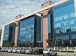 Noida, IT Capital of Uttar Pradesh
 -


.jpg)

See also
- List of urban agglomerations in Uttar Pradesh
- List of cities in Maharashtra
- List of states and union territories of India by population
References
- ^ "State division of Uttar Pradesh". Government of India. Retrieved 22 July 2012.
- ^ a b c "Uttar Pradesh Population 2011". Government of India. 2011 Census of India. Retrieved 8 October 2012.
- ^ "Ranking of States and Union territories by population size : 1991 and 2001" (PDF). Government of India (2001). Census of India. pp. 5–6. Retrieved 12 December 2008.
- ^ "Size, Growth rate and population distribution" (PDF). Government of India. 2011 Census of India. Retrieved 8 October 2012.
- ^ Cite error: The named reference
ProvisionalPopulationwas invoked but never defined (see the help page). - ^ "District Census 2011". Government of India. 2011 Census of India. Retrieved 8 October 2012.
- ^ "List of cities with their population" (PDF). Government of India. 2011 Census of India. Retrieved 8 October 2012.
- ^ a b c d "Data Sheet on Key Gender Statistics". Government of India. 2011 Census of India. Retrieved 8 October 2012.


