
Taoyuan Metro
| Taoyuan Metro | |||||||
|---|---|---|---|---|---|---|---|
| Overview | |||||||
| Native name | 桃園捷運 | ||||||
| Chinese name | |||||||
| Traditional Chinese | 桃園捷運 | ||||||
| |||||||
| Owner | Taoyuan City Government | ||||||
| Locale | Taoyuan and New Taipei, Taiwan | ||||||
| Transit type | Rapid transit | ||||||
| Number of lines | 1 | ||||||
| Number of stations | 21 | ||||||
| Annual ridership | 23.214 million (2018)[1] | ||||||
| Website | Taoyuan Metro Corp. (in Chinese) | ||||||
| Operation | |||||||
| Began operation | 2 March 2017[2] | ||||||
| Operator(s) | Taoyuan Metro Corporation | ||||||
| Technical | |||||||
| System length | 51.03 km (31.71 mi) | ||||||
| Track gauge | 1,435 mm (4 ft 8+1⁄2 in) | ||||||
| |||||||

Taoyuan Metro (formerly Taoyuan Rail Transit and officially Taoyuan Mass Rapid Transit System) is a rapid transit system serving the Taoyuan City area in Taiwan.[3] The proposed network will consist of five lines. One line is currently operating. The system opened for commercial service on 2 March 2017 with the opening of the Taoyuan Airport MRT.
History
- 02 March 2017: Purple line (full name is Taoyuan Airport MRT) opened for service.
Network and operations
Lines
| Line | Termini (District, City) |
Stations | Length (km) |
Depot | |||
|---|---|---|---|---|---|---|---|
| Taoyuan Airport MRT [Note 1] |
Taipei Main Station (Zhongzheng, Taipei) |
Huanbei (Zhongli, Taoyuan) |
21 | 51.03 | Chingpu | ||
Infrastructure
Taoyuan Airport Line
Trains
Airport trains come in two types, commuter and express train.[4] Express trains call at Taipei Main Station, New Taipei Industrial Park, Chang Gung Memorial Hospital, Airport Terminal 1, Airport Terminal 2. Commuter trains stop at every station.
-
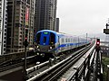 Commuter train
 -
 Express train
 -
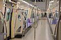 Interior of a Commuter train
 -
 Interior of an Express train


Free Wi-Fi
Free Wi-Fi is available throughout the system.

Future expansion
All lines will use standard gauge track, with the exception of the Red line which will use 3 ft 6 in (1,067 mm) track as it is basically a reconsruction of the Taoyuan portion of the TRA Western Line into an underground railway tunnel intended to support more frequent, rapid transit-like local rail services (rather like the reconstruction of TRA railways in Greater Taipei and Kaohsiung). The Taolin Line segment of the Brown Line from Taoyuan to Shanbi is intended to be built as a bus rapid transit route.
| Line | Termini | Length (km) | Status | |||
|---|---|---|---|---|---|---|
| Taoyuan Airport MRT | Huanbei | Zhongli | 2.29 | Under Construction | ||
| Zhongli Railway Station | Zhongli Sports Park | Planning | ||||
| Green Line | Danan/Bade | Kengkou/Hengshan | 27.2 | Under Construction | ||
| Daxi Line | Bade | Daxi | 10 | Planning | ||
| Zhongli Line | Bade | Zhongli Sports Park | Planning | |||
| Orange Line | Shanzaiding | Tongan | Planning | |||
| Longtan Line | Shanzaiding | Longtan | 6 | Planning | ||
| Taolin Line | Taoyuan Main Station | Shanbi | 12.5 | Planning | ||
| Huilong Line | Taoyuan Main Station | Huilong | 11.5 | Planning | ||

Construction
In March 2011, the Bureau of High Speed Rail, which oversees construction of the project, announced that the 11.4 km (7.1 mi)-long elevated structure from Dayuan Station (A15) to Xingnan Station (A20) had been completed.[5] The rest of the Taoyuan Line passed an environmental impact assessment in July 2014. Construction was expected to last from June 2015 to 2019.[6]
Network Map

See also
Notes
- ^ The Airport MRT is also known as the Purple Line for the color scheme, and occasionally known as Blue Line as it was partially designated as such.
References
- ^ "Mass Rapid Transit". stat.motc.gov.tw. Retrieved 18 February 2019.
- ^ 黃立偉, 張國樑 (25 January 2017). 春節後試營運 機捷敲定3月2日上路. PTS NEWS (in Chinese).
- ^ 桃園都會區大眾捷運系統 (in Chinese). Department of Rapid Transit Systems. 2008-07-01. Retrieved 2010-06-19.
- ^ https://www.tymetro.com.tw/tymetro-new/tw/_pages/travel-guide/introduce.html
- ^ 《交通》機場捷運大園至中壢路段高架橋全部合龍. 中時電子報 (in Chinese). 2011-03-07. Retrieved 2011-03-07.
- ^ Chiu, Chun-chin; Holzer, Wesley; Kao, Evelyn (2014-07-17). "Taoyuan MRT green line passes evaluation, could be finished by 2019". Central News Agency. Retrieved 2014-07-17.
External links
![]() Media related to Taoyuan MRT at Wikimedia Commons
Media related to Taoyuan MRT at Wikimedia Commons
- Taoyuan Metro Corp. – official website
- Taoyuan MRT by the Transportation Department, Taoyuan County Government
| Inter-city | |
|---|---|
| Urban transit | |
| Industrial and Tourist | |
Rapid transit in Asia | |
|---|---|
| |
* Under construction. | |
This Taiwanese rapid transit article is a stub. You can help Wikipedia by expanding it. |