
List of municipalities in Michigan

Michigan is a state located in the Midwest region of the United States. According to the 2020 United States Census, Michigan is the 10th most populous state with 10,077,331 inhabitants and the 22nd largest by land area spanning 56,538.90 square miles (146,435.1 km2) of land.[1] Michigan is divided into 83 counties and contains 1,773 municipalities consisting of 276 cities, 257 villages, and 1,240 townships.[2] The largest municipality by population in Michigan is Detroit with 639,111 residents;[1] the smallest municipality by population is Pointe Aux Barques Township with 15 residents.[3] The largest municipality by land area is McMillan Township which spans 588.78 sq mi (1,524.9 km2), while Ahmeek is the smallest at 0.07 sq mi (0.18 km2).[4]
Municipalities may be incorporated as cities, villages, or charter townships, which are unique to Michigan compared to other U.S. states.[5][6] General law townships are unincorporated but provide some municipal services. Cities are not subject to a township's jurisdiction, but villages remain part of the township in which they are located; village residents pay both township and village taxes, and share services with the township. Since all Michigan residents who do not live in a city live in a township, a village's population is counted in the population of the township in which it is located.[7]
List of municipalities[edit]
- Largest municipalities in Michigan by population (2020 U.S. Census)[8]
-

-
 Grand Rapids, the second largest city in Michigan by population
 -
 Ann Arbor, the fifth largest city in Michigan by population
 -
 Lansing, the capital and sixth largest city in Michigan by population
 -
 Dearborn, the seventh largest city in Michigan by population
 -
 Troy, the twelfth largest city in Michigan by population
 -
 Flint, the fifteenth largest city in Michigan by population
 -
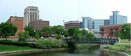 Kalamazoo, the twentieth largest city in Michigan by population
.jpg)


| Name | Type[4] | County[4] | Population (2020)[1] |
Population (2010)[4] |
Change | Population (2000)[4] |
Land area (2010)[4] |
Density (2010) | |
|---|---|---|---|---|---|---|---|---|---|
| sq mi | km2 | ||||||||
| Acme | Township | Grand Traverse | 4,456 | 4,375 | +1.9% | 4,332 | 25.01 | 64.8 | 174.9/sq mi (67.5/km2) |
| Ada | Township | Kent | 14,388 | 13,142 | +9.5% | 9,882 | 36.04 | 93.3 | 364.7/sq mi (140.8/km2) |
| Adams | Township | Arenac | 554 | 563 | −1.6% | 550 | 35.64 | 92.3 | 15.8/sq mi (6.1/km2) |
| Adams | Township | Hillsdale | 2,327 | 2,493 | −6.7% | 2,498 | 35.64 | 92.3 | 69.9/sq mi (27.0/km2) |
| Adams | Township | Houghton | 2,540 | 2,573 | −1.3% | 2,747 | 47.05 | 121.9 | 54.7/sq mi (21.1/km2) |
| Addison | Village | Lenawee | 573 | 605 | −5.3% | 627 | 0.96 | 2.5 | 630.2/sq mi (243.3/km2) |
| Addison | Township | Oakland | 6,256 | 6,351 | −1.5% | 6,439 | 35.52 | 92.0 | 178.8/sq mi (69.0/km2) |
| Adrian† | City | Lenawee | 20,645 | 21,133 | −2.3% | 21,574 | 7.95 | 20.6 | 2,658.2/sq mi (1,026.4/km2) |
| Adrian | Charter Township | Lenawee | 6,401 | 6,035 | +6.1% | 5,749 | 33.99 | 88.0 | 177.6/sq mi (68.6/km2) |
| Aetna | Township | Mecosta | 2,241 | 2,299 | −2.5% | 2,044 | 35.52 | 92.0 | 64.7/sq mi (25.0/km2) |
| Aetna | Township | Missaukee | 429 | 413 | +3.9% | 491 | 35.88 | 92.9 | 11.5/sq mi (4.4/km2) |
| Ahmeek | Village | Keweenaw | 127 | 146 | −13.0% | 157 | 0.07 | 0.18 | 2,085.7/sq mi (805.3/km2) |
| Akron | Village | Tuscola | 349 | 402 | −13.2% | 461 | 0.94 | 2.4 | 427.7/sq mi (165.1/km2) |
| Akron | Township | Tuscola | 1,379 | 1,503 | −8.3% | 1,589 | 52.75 | 136.6 | 28.5/sq mi (11.0/km2) |
| Alabaster | Township | Iosco | 424 | 487 | −12.9% | 503 | 22.22 | 57.5 | 21.9/sq mi (8.5/km2) |
| Alaiedon | Township | Ingham | 2,910 | 2,894 | +0.6% | 3,498 | 35.60 | 92.2 | 81.3/sq mi (31.4/km2) |
| Alamo | Township | Kalamazoo | 3,805 | 3,762 | +1.1% | 3,820 | 36.20 | 93.8 | 103.9/sq mi (40.1/km2) |
| Alanson | Village | Emmet | 778 | 738 | +5.4% | 785 | 0.99 | 2.6 | 745.5/sq mi (287.8/km2) |
| Albee | Township | Saginaw | 2,046 | 2,160 | −5.3% | 2,338 | 36.04 | 93.3 | 59.9/sq mi (23.1/km2) |
| Albert | Township | Montmorency | 2,453 | 2,526 | −2.9% | 2,695 | 65.66 | 170.1 | 38.5/sq mi (14.9/km2) |
| Albion | City | Calhoun | 7,700 | 8,616 | −10.6% | 9,144 | 4.41 | 11.4 | 1,953.7/sq mi (754.3/km2) |
| Albion | Township | Calhoun | 1,094 | 1,123 | −2.6% | 1,200 | 32.63 | 84.5 | 34.4/sq mi (13.3/km2) |
| Alcona | Township | Alcona | 966 | 968 | −0.2% | 1,089 | 57.5 | 149 | 16.8/sq mi (6.5/km2) |
| Algansee | Township | Branch | 2,033 | 1,974 | +3.0% | 2,061 | 35.53 | 92.0 | 55.6/sq mi (21.5/km2) |
| Algoma | Township | Kent | 12,055 | 9,932 | +21.4% | 7,596 | 34.13 | 88.4 | 291.0/sq mi (112.4/km2) |
| Algonac | City | St. Clair | 4,196 | 4,110 | +2.1% | 4,613 | 1.43 | 3.7 | 2,874.1/sq mi (1,109.7/km2) |
| Allegan† | City | Allegan | 5,222 | 4,998 | +4.5% | 4,838 | 3.85 | 10.0 | 1,298.2/sq mi (501.2/km2) |
| Allegan | Township | Allegan | 4,689 | 4,406 | +6.4% | 4,050 | 30.40 | 78.7 | 144.9/sq mi (56.0/km2) |
| Allen | Village | Hillsdale | 201 | 191 | +5.2% | 225 | 0.16 | 0.41 | 1,193.8/sq mi (460.9/km2) |
| Allen | Township | Hillsdale | 1,602 | 1,657 | −3.3% | 1,631 | 36.01 | 93.3 | 46.0/sq mi (17.8/km2) |
| Allendale | Charter Township | Ottawa | 26,582 | 20,708 | +28.4% | 13,042 | 31.13 | 80.6 | 665.2/sq mi (256.8/km2) |
| Allen Park | City | Wayne | 28,638 | 28,210 | +1.5% | 29,376 | 7.00 | 18.1 | 4,030.0/sq mi (1,556.0/km2) |
| Allis | Township | Presque Isle | 925 | 948 | −2.4% | 1,035 | 64.75 | 167.7 | 14.6/sq mi (5.7/km2) |
| Allouez | Township | Keweenaw | 1,428 | 1,571 | −9.1% | 1,584 | 54.62 | 141.5 | 28.8/sq mi (11.1/km2) |
| Alma | City | Gratiot | 9,488 | 9,383 | +1.1% | 9,275 | 5.93 | 15.4 | 1,582.3/sq mi (610.9/km2) |
| Almena | Township | Van Buren | 5,308 | 4,992 | +6.3% | 4,226 | 34.41 | 89.1 | 145.1/sq mi (56.0/km2) |
| Almer | Charter Township | Tuscola | 1,965 | 3,101 | −36.6% | 3,023 | 34.09 | 88.3 | 91.0/sq mi (35.1/km2) |
| Almira | Township | Benzie | 3,873 | 3,645 | +6.3% | 2,811 | 33.75 | 87.4 | 108.0/sq mi (41.7/km2) |
| Almont | Village | Lapeer | 2,846 | 2,674 | +6.4% | 2,803 | 1.42 | 3.7 | 1,883.1/sq mi (727.1/km2) |
| Almont | Township | Lapeer | 6,961 | 6,583 | +5.7% | 6041 | 36.66 | 94.9 | 179.6/sq mi (69.3/km2) |
| Aloha | Township | Cheboygan | 937 | 949 | −1.3% | 1,041 | 29.5 | 76 | 32.2/sq mi (12.4/km2) |
| Alpena† | City | Alpena | 10,197 | 10,483 | −2.7% | 11,304 | 8.54 | 22.1 | 1,227.5/sq mi (473.9/km2) |
| Alpena | Charter Township | Alpena | 9,116 | 9,060 | +0.6% | 9,788 | 104.45 | 270.5 | 86.7/sq mi (33.5/km2) |
| Alpha | Village | Iron | 126 | 145 | −13.1% | 198 | 0.94 | 2.4 | 154.3/sq mi (59.6/km2) |
| Alpine | Township | Kent | 14,079 | 13,336 | +5.6% | 13,976 | 35.9 | 93 | 371.5/sq mi (143.4/km2) |
| Amber | Township | Mason | 2,529 | 2,535 | −0.2% | 2,054 | 27.55 | 71.4 | 92.0/sq mi (35.5/km2) |
| Amboy | Township | Hillsdale | 1,176 | 1,173 | +0.3% | 1,224 | 29.96 | 77.6 | 39.2/sq mi (15.1/km2) |
| Ann Arbor† | City | Washtenaw | 123,851 | 113,934 | +8.7% | 114,024 | 27.83 | 72.1 | 4,093.9/sq mi (1,580.7/km2) |
| Ann Arbor | Charter Township | Washtenaw | 4,673 | 4,361 | +7.2% | 4,720 | 16.73 | 43.3 | 260.7/sq mi (100.6/km2) |
| Antioch | Township | Wexford | 900 | 815 | +10.4% | 810 | 35.22 | 91.2 | 23.1/sq mi (8.9/km2) |
| Antrim | Township | Shiawassee | 2,116 | 2,161 | −2.1% | 2,050 | 35.33 | 91.5 | 61.2/sq mi (23.6/km2) |
| Antwerp | Township | Van Buren | 13,425 | 12,182 | +10.2% | 10,813 | 34.69 | 89.8 | 351.2/sq mi (135.6/km2) |
| Applegate | Village | Sanilac | 241 | 248 | −2.8% | 287 | 1 | 2.6 | 248.0/sq mi (95.8/km2) |
| Arbela | Township | Tuscola | 2,808 | 3,070 | −8.5% | 3,219 | 33.46 | 86.7 | 91.8/sq mi (35.4/km2) |
| Arcada | Township | Gratiot | 1,671 | 1,681 | −0.6% | 1,708 | 32.17 | 83.3 | 52.3/sq mi (20.2/km2) |
| Arcadia | Township | Lapeer | 3,148 | 3,113 | +1.1% | 3,197 | 35.05 | 90.8 | 88.8/sq mi (34.3/km2) |
| Arcadia | Township | Manistee | 657 | 639 | +2.8% | 621 | 18.59 | 48.1 | 34.4/sq mi (13.3/km2) |
| Arenac | Township | Arenac | 871 | 903 | −3.5% | 992 | 35.77 | 92.6 | 25.2/sq mi (9.7/km2) |
| Argentine | Township | Genesee | 7,091 | 6,913 | +2.6% | 6,521 | 34.65 | 89.7 | 199.5/sq mi (77.0/km2) |
| Argyle | Township | Sanilac | 687 | 759 | −9.5% | 770 | 36.31 | 94.0 | 20.9/sq mi (8.1/km2) |
| Arlington | Township | Van Buren | 1,958 | 2,073 | −5.5% | 2,075 | 34.37 | 89.0 | 60.3/sq mi (23.3/km2) |
| Armada | Village | Macomb | 1,684 | 1,730 | −2.7% | 1,573 | 0.76 | 2.0 | 2,276.3/sq mi (878.9/km2) |
| Armada | Township | Macomb | 5,318 | 5,379 | −1.1% | 5,246 | 36.48 | 94.5 | 147.5/sq mi (56.9/km2) |
| Arthur | Township | Clare | 676 | 647 | +4.5% | 667 | 36.02 | 93.3 | 18.0/sq mi (6.9/km2) |
| Arvon | Township | Baraga | 492 | 450 | +9.3% | 482 | 123.96 | 321.1 | 3.6/sq mi (1.4/km2) |
| Ash | Township | Monroe | 7,860 | 7,783 | +1.0% | 7,610 | 34.60 | 89.6 | 224.9/sq mi (86.9/km2) |
| Ashland | Township | Newaygo | 2,764 | 2,773 | −0.3% | 2,570 | 34.42 | 89.1 | 80.6/sq mi (31.1/km2) |
| Ashley | Village | Gratiot | 508 | 563 | −9.8% | 526 | 0.64 | 1.7 | 879.7/sq mi (339.6/km2) |
| Assyria | Township | Barry | 1,992 | 1,986 | +0.3% | 1,912 | 35.87 | 92.9 | 55.4/sq mi (21.4/km2) |
| Athens | Village | Calhoun | 936 | 1,024 | −8.6% | 1,111 | 1.01 | 2.6 | 1,013.9/sq mi (391.5/km2) |
| Athens | Township | Calhoun | 2,444 | 2,554 | −4.3% | 2,571 | 35.94 | 93.1 | 71.1/sq mi (27.4/km2) |
| Atlas | Township | Genesee | 8,352 | 7,993 | +4.5% | 7,257 | 35.22 | 91.2 | 226.9/sq mi (87.6/km2) |
| Attica | Township | Lapeer | 4,706 | 4,755 | −1.0% | 4,678 | 35.09 | 90.9 | 135.5/sq mi (52.3/km2) |
| Auburn | City | Bay | 2,068 | 2,087 | −0.9% | 2,011 | 1.05 | 2.7 | 1,987.6/sq mi (767.4/km2) |
| Auburn Hills | City | Oakland | 24,360 | 21,412 | +13.8% | 19,837 | 16.6 | 43 | 1,289.9/sq mi (498.0/km2) |
| Au Gres | City | Arenac | 945 | 889 | +6.3% | 1,028 | 2.23 | 5.8 | 398.7/sq mi (153.9/km2) |
| Au Gres | Township | Arenac | 896 | 953 | −6.0% | 1,007 | 33.35 | 86.4 | 28.6/sq mi (11.0/km2) |
| Augusta | Village | Kalamazoo | 864 | 885 | −2.4% | 899 | 1.01 | 2.6 | 876.2/sq mi (338.3/km2) |
| Augusta | Charter Township | Washtenaw | 7,083 | 6,745 | +5.0% | 4,813 | 36.70 | 95.1 | 183.8/sq mi (71.0/km2) |
| Aurelius | Township | Ingham | 4,354 | 3,525 | +23.5% | 3,318 | 36.41 | 94.3 | 96.8/sq mi (37.4/km2) |
| Au Sable | Charter Township | Iosco | 2,016 | 2,047 | −1.5% | 2,230 | 20.63 | 53.4 | 99.2/sq mi (38.3/km2) |
| Au Sable | Township | Roscommon | 236 | 255 | −7.5% | 281 | 35.66 | 92.4 | 7.2/sq mi (2.8/km2) |
| Austin | Township | Mecosta | 1,715 | 1,561 | +9.9% | 1,415 | 35.67 | 92.4 | 43.8/sq mi (16.9/km2) |
| Austin | Township | Sanilac | 619 | 665 | −6.9% | 673 | 36.15 | 93.6 | 18.4/sq mi (7.1/km2) |
| Au Train | Township | Alger | 1,019 | 1,138 | −10.5% | 1,172 | 141.27 | 365.9 | 8.1/sq mi (3.1/km2) |
| Avery | Township | Montmorency | 662 | 646 | +2.5% | 717 | 35.02 | 90.7 | 18.4/sq mi (7.1/km2) |
| Backus | Township | Roscommon | 294 | 330 | −10.9% | 350 | 34.36 | 89.0 | 9.6/sq mi (3.7/km2) |
| Bad Axe† | City | Huron | 3,021 | 3,129 | −3.5% | 3,462 | 2.26 | 5.9 | 1,384.5/sq mi (534.6/km2) |
| Bagley | Township | Otsego | 5,867 | 5,886 | −0.3% | 5,838 | 28.10 | 72.8 | 209.5/sq mi (80.9/km2) |
| Bainbridge | Township | Berrien | 2,682 | 2,850 | −5.9% | 3,132 | 34.90 | 90.4 | 81.7/sq mi (31.5/km2) |
| Baldwin | Township | Delta | 700 | 759 | −7.8% | 748 | 83.86 | 217.2 | 9.1/sq mi (3.5/km2) |
| Baldwin | Township | Iosco | 1,614 | 1,694 | −4.7% | 1,726 | 28.42 | 73.6 | 59.6/sq mi (23.0/km2) |
| Baldwin† | Village | Lake | 902 | 1,208 | −25.3% | 1,107 | 1.26 | 3.3 | 958.7/sq mi (370.2/km2) |
| Baltimore | Township | Barry | 1,947 | 1,861 | +4.6% | 1,845 | 35.42 | 91.7 | 52.5/sq mi (20.3/km2) |
| Bancroft | Village | Shiawassee | 484 | 545 | −11.2% | 616 | 0.58 | 1.5 | 939.7/sq mi (362.8/km2) |
| Bangor | Charter Township | Bay | 14,045 | 14,641 | −4.1% | 15,547 | 14.10 | 36.5 | 1,038.4/sq mi (400.9/km2) |
| Bangor | City | Van Buren | 2,016 | 1,885 | +6.9% | 1,933 | 1.83 | 4.7 | 1,030.1/sq mi (397.7/km2) |
| Bangor | Township | Van Buren | 1,939 | 2,147 | −9.7% | 2,121 | 33.70 | 87.3 | 63.7/sq mi (24.6/km2) |
| Banks | Township | Antrim | 1,588 | 1,609 | −1.3% | 1,813 | 44.94 | 116.4 | 35.8/sq mi (13.8/km2) |
| Baraga | Village | Baraga | 1,883 | 2,053 | −8.3% | 1,285 | 2.12 | 5.5 | 968.4/sq mi (373.9/km2) |
| Baraga | Township | Baraga | 3,478 | 3,815 | −8.8% | 3,542 | 183.80 | 476.0 | 20.8/sq mi (8.0/km2) |
| Bark River | Township | Delta | 1,595 | 1,578 | +1.1% | 1,650 | 45.59 | 118.1 | 34.6/sq mi (13.4/km2) |
| Baroda | Village | Berrien | 875 | 873 | +0.2% | 858 | 0.72 | 1.9 | 1,212.5/sq mi (468.1/km2) |
| Baroda | Township | Berrien | 2,835 | 2,801 | +1.2% | 2,880 | 17.77 | 46.0 | 157.6/sq mi (60.9/km2) |
| Barry | Township | Barry | 3,417 | 3,378 | +1.2% | 3,489 | 34.43 | 89.2 | 98.1/sq mi (37.9/km2) |
| Barryton | Village | Mecosta | 405 | 355 | +14.1% | 381 | 0.96 | 2.5 | 369.8/sq mi (142.8/km2) |
| Barton | Township | Newaygo | 706 | 717 | −1.5% | 820 | 35.06 | 90.8 | 20.5/sq mi (7.9/km2) |
| Barton Hills | Village | Washtenaw | 316 | 294 | +7.5% | 335 | 0.75 | 1.9 | 392.0/sq mi (151.4/km2) |
| Batavia | Township | Branch | 1,323 | 1,339 | −1.2% | 1,546 | 35.73 | 92.5 | 37.5/sq mi (14.5/km2) |
| Bates | Township | Iron | 925 | 921 | +0.4% | 1,021 | 125.69 | 325.5 | 7.3/sq mi (2.8/km2) |
| Bath | Charter Township | Clinton | 13,292 | 11,598 | +14.6% | 7,541 | 31.83 | 82.4 | 364.4/sq mi (140.7/km2) |
| Battle Creek | City | Calhoun | 52,721 | 52,347 | +0.7% | 53,364 | 42.61 | 110.4 | 1,228.5/sq mi (474.3/km2) |
| Bay | Township | Charlevoix | 1,142 | 1,122 | +1.8% | 1,068 | 15.55 | 40.3 | 72.2/sq mi (27.9/km2) |
| Bay City† | City | Bay | 32,661 | 34,932 | −6.5% | 36,817 | 10.17 | 26.3 | 3,434.8/sq mi (1,326.2/km2) |
| Bay de Noc | Township | Delta | 300 | 305 | −1.6% | 329 | 67.66 | 175.2 | 4.5/sq mi (1.7/km2) |
| Bay Mills | Township | Chippewa | 1,567 | 1,477 | +6.1% | 1,214 | 64.72 | 167.6 | 22.8/sq mi (8.8/km2) |
| Bear Creek | Township | Emmet | 6,542 | 6,201 | +5.5% | 5,269 | 39.57 | 102.5 | 156.7/sq mi (60.5/km2) |
| Bearinger | Township | Presque Isle | 371 | 369 | +0.5% | 329 | 61.44 | 159.1 | 6.0/sq mi (2.3/km2) |
| Bear Lake | Township | Kalkaska | 668 | 667 | +0.1% | 746 | 71.09 | 184.1 | 9.4/sq mi (3.6/km2) |
| Bear Lake | Village | Manistee | 342 | 286 | +19.6% | 318 | 0.31 | 0.80 | 922.6/sq mi (356.2/km2) |
| Bear Lake | Township | Manistee | 1,831 | 1,751 | +4.6% | 1,587 | 34.69 | 89.8 | 50.5/sq mi (19.5/km2) |
| Beaugrand | Township | Cheboygan | 1,092 | 1,168 | −6.5% | 1,157 | 23.83 | 61.7 | 49.0/sq mi (18.9/km2) |
| Beaver | Township | Bay | 2,723 | 2,885 | −5.6% | 2,806 | 35.34 | 91.5 | 81.6/sq mi (31.5/km2) |
| Beaver | Township | Newaygo | 463 | 509 | −9.0% | 608 | 32.06 | 83.0 | 15.9/sq mi (6.1/km2) |
| Beaver Creek | Township | Crawford | 1,515 | 1,736 | −12.7% | 1,486 | 71.46 | 185.1 | 24.3/sq mi (9.4/km2) |
| Beaverton | City | Gladwin | 1,145 | 1,071 | +6.9% | 1,106 | 1.03 | 2.7 | 1,039.8/sq mi (401.5/km2) |
| Beaverton | Township | Gladwin | 1,863 | 1,964 | −5.1% | 1,815 | 35.03 | 90.7 | 56.1/sq mi (21.6/km2) |
| Bedford | Charter Township | Calhoun | 9,198 | 9,357 | −1.7% | 9,517 | 29.10 | 75.4 | 321.5/sq mi (124.1/km2) |
| Bedford | Township | Monroe | 31,813 | 31,085 | +2.3% | 28,606 | 39.19 | 101.5 | 793.2/sq mi (306.3/km2) |
| Belding | City | Ionia | 5,938 | 5,757 | +3.1% | 5,877 | 4.72 | 12.2 | 1,219.7/sq mi (470.9/km2) |
| Belknap | Township | Presque Isle | 686 | 751 | −8.7% | 854 | 35.70 | 92.5 | 21.0/sq mi (8.1/km2) |
| Bellaire† | Village | Antrim | 1,053 | 1,086 | −3.0% | 1,164 | 1.84 | 4.8 | 590.2/sq mi (227.9/km2) |
| Belleville | City | Wayne | 4,008 | 3,991 | +0.4% | 3,997 | 1.14 | 3.0 | 3,500.9/sq mi (1,351.7/km2) |
| Bellevue | Village | Eaton | 1,308 | 1,282 | +2.0% | 1,365 | 1.02 | 2.6 | 1,256.9/sq mi (485.3/km2) |
| Bellevue | Township | Eaton | 3,200 | 3,150 | +1.6% | 3,144 | 36.38 | 94.2 | 86.6/sq mi (33.4/km2) |
| Belvidere | Township | Montcalm | 2,135 | 2,209 | −3.3% | 2,438 | 34.62 | 89.7 | 63.8/sq mi (24.6/km2) |
| Bengal | Township | Clinton | 1,138 | 1,188 | −4.2% | 1,174 | 36.53 | 94.6 | 32.5/sq mi (12.6/km2) |
| Bennington | Township | Shiawassee | 3,119 | 3,168 | −1.5% | 3,017 | 35.48 | 91.9 | 89.3/sq mi (34.5/km2) |
| Benona | Township | Oceana | 1,425 | 1,437 | −0.8% | 1,520 | 40.38 | 104.6 | 35.6/sq mi (13.7/km2) |
| Bentley | Township | Gladwin | 829 | 844 | −1.8% | 859 | 34.70 | 89.9 | 24.3/sq mi (9.4/km2) |
| Benton | Charter Township | Berrien | 14,374 | 14,749 | −2.5% | 16,404 | 32.37 | 83.8 | 455.6/sq mi (175.9/km2) |
| Benton | Township | Cheboygan | 3,133 | 3,206 | −2.3% | 3,080 | 58.66 | 151.9 | 54.7/sq mi (21.1/km2) |
| Benton | Township | Eaton | 2,766 | 2,796 | −1.1% | 2,712 | 33.54 | 86.9 | 83.4/sq mi (32.2/km2) |
| Benton Harbor | City | Berrien | 9,103 | 10,038 | −9.3% | 11,182 | 4.43 | 11.5 | 2,265.9/sq mi (874.9/km2) |
| Benzonia | Village | Benzie | 551 | 497 | +10.9% | 519 | 1.13 | 2.9 | 439.8/sq mi (169.8/km2) |
| Benzonia | Township | Benzie | 2,734 | 2,727 | +0.3% | 2,839 | 27.81 | 72.0 | 98.1/sq mi (37.9/km2) |
| Bergland | Township | Ontonagon | 438 | 467 | −6.2% | 550 | 98.50 | 255.1 | 4.7/sq mi (1.8/km2) |
| Berkley | City | Oakland | 15,194 | 14,970 | +1.5% | 15,531 | 2.61 | 6.8 | 5,735.6/sq mi (2,214.5/km2) |
| Berlin | Township | Ionia | 2,138 | 2,116 | +1.0% | 2,787 | 41.55 | 107.6 | 50.9/sq mi (19.7/km2) |
| Berlin | Charter Township | Monroe | 9,890 | 9,299 | +6.4% | 6,924 | 32.00 | 82.9 | 290.6/sq mi (112.2/km2) |
| Berlin | Township | St. Clair | 3,115 | 3,285 | −5.2% | 3,162 | 37.12 | 96.1 | 88.5/sq mi (34.2/km2) |
| Berrien | Township | Berrien | 4,868 | 5,084 | −4.2% | 5,075 | 35.07 | 90.8 | 145.0/sq mi (56.0/km2) |
| Berrien Springs | Village | Berrien | 1,910 | 1,800 | +6.1% | 1,862 | 0.94 | 2.4 | 1,914.9/sq mi (739.3/km2) |
| Bertrand | Township | Berrien | 2,611 | 2,657 | −1.7% | 2,380 | 34.44 | 89.2 | 77.1/sq mi (29.8/km2) |
| Bessemer† | City | Gogebic | 1,805 | 1,905 | −5.2% | 2,148 | 5.47 | 14.2 | 348.3/sq mi (134.5/km2) |
| Bessemer | Township | Gogebic | 1,135 | 1,176 | −3.5% | 1,270 | 113.73 | 294.6 | 10.3/sq mi (4.0/km2) |
| Bethany | Township | Gratiot | 1,773 | 1,407 | +26.0% | 3,492 | 34.57 | 89.5 | 40.7/sq mi (15.7/km2) |
| Bethel | Township | Branch | 1,431 | 1,434 | −0.2% | 1,421 | 35.83 | 92.8 | 40.0/sq mi (15.5/km2) |
| Beulah† | Village | Benzie | 313 | 342 | −8.5% | 363 | 0.43 | 1.1 | 795.3/sq mi (307.1/km2) |
| Beverly Hills | Village | Oakland | 10,584 | 10,267 | +3.1% | 10,437 | 4.00 | 10.4 | 2,566.8/sq mi (991.0/km2) |
| Big Creek | Township | Oscoda | 2,604 | 2,827 | −7.9% | 3,380 | 141.66 | 366.9 | 20.0/sq mi (7.7/km2) |
| Big Prairie | Township | Newaygo | 2,436 | 2,573 | −5.3% | 2,465 | 31.39 | 81.3 | 82.0/sq mi (31.6/km2) |
| Big Rapids† | City | Mecosta | 7,727 | 10,601 | −27.1% | 10,849 | 4.36 | 11.3 | 2,431.4/sq mi (938.8/km2) |
| Big Rapids | Charter Township | Mecosta | 3,917 | 4,208 | −6.9% | 3,249 | 30.53 | 79.1 | 137.8/sq mi (53.2/km2) |
| Billings | Township | Gladwin | 2,318 | 2,416 | −4.1% | 2,715 | 21.56 | 55.8 | 112.1/sq mi (43.3/km2) |
| Bingham | Township | Clinton | 2,919 | 2,859 | +2.1% | 2,776 | 32.39 | 83.9 | 88.3/sq mi (34.1/km2) |
| Bingham | Township | Huron | 1,642 | 1,709 | −3.9% | 1,751 | 35.76 | 92.6 | 47.8/sq mi (18.5/km2) |
| Bingham | Township | Leelanau | 2,577 | 2,497 | +3.2% | 2,425 | 23.57 | 61.0 | 105.9/sq mi (40.9/km2) |
| Bingham Farms | Village | Oakland | 1,124 | 1,111 | +1.2% | 1,030 | 1.21 | 3.1 | 918.2/sq mi (354.5/km2) |
| Birch Run | Village | Saginaw | 1,525 | 1,555 | −1.9% | 1,653 | 1.89 | 4.9 | 822.8/sq mi (317.7/km2) |
| Birch Run | Township | Saginaw | 5,888 | 6,033 | −2.4% | 6,191 | 35.51 | 92.0 | 169.9/sq mi (65.6/km2) |
| Birmingham | City | Oakland | 21,813 | 20,103 | +8.5% | 19,291 | 4.79 | 12.4 | 4,196.9/sq mi (1,620.4/km2) |
| Bismarck | Township | Presque Isle | 351 | 386 | −9.1% | 408 | 67.51 | 174.9 | 5.7/sq mi (2.2/km2) |
| Blackman | Charter Township | Jackson | 25,642 | 24,051 | +6.6% | 22,800 | 31.71 | 82.1 | 758.5/sq mi (292.8/km2) |
| Blaine | Township | Benzie | 484 | 551 | −12.2% | 491 | 19.43 | 50.3 | 28.4/sq mi (10.9/km2) |
| Blair | Township | Grand Traverse | 8,994 | 8,209 | +9.6% | 6,448 | 35.61 | 92.2 | 230.5/sq mi (89.0/km2) |
| Blendon | Township | Ottawa | 7,081 | 5,772 | +22.7% | 5,721 | 36.36 | 94.2 | 158.7/sq mi (61.3/km2) |
| Bliss | Township | Emmet | 568 | 620 | −8.4% | 572 | 43.66 | 113.1 | 14.2/sq mi (5.5/km2) |
| Blissfield | Village | Lenawee | 3,277 | 3,340 | −1.9% | 3,223 | 2.24 | 5.8 | 1,491.1/sq mi (575.7/km2) |
| Blissfield | Township | Lenawee | 3,924 | 3,973 | −1.2% | 3,915 | 20.88 | 54.1 | 190.3/sq mi (73.5/km2) |
| Bloomer | Township | Montcalm | 6,352 | 3,904 | +62.7% | 3,039 | 34.77 | 90.1 | 112.3/sq mi (43.4/km2) |
| Bloomfield | Township | Huron | 404 | 455 | −11.2% | 535 | 35.74 | 92.6 | 12.7/sq mi (4.9/km2) |
| Bloomfield | Township | Missaukee | 574 | 531 | +8.1% | 475 | 35.54 | 92.0 | 14.9/sq mi (5.8/km2) |
| Bloomfield | Charter Township | Oakland | 44,253 | 41,070 | +7.8% | 43,023 | 24.63 | 63.8 | 1,667.5/sq mi (643.8/km2) |
| Bloomfield Hills | City | Oakland | 4,460 | 3,869 | +15.3% | 3,940 | 4.96 | 12.8 | 780.0/sq mi (301.2/km2) |
| Bloomingdale | Village | Van Buren | 513 | 454 | +13.0% | 528 | 1.14 | 3.0 | 398.2/sq mi (153.8/km2) |
| Bloomingdale | Township | Van Buren | 2,930 | 3,103 | −5.6% | 3,364 | 33.91 | 87.8 | 91.5/sq mi (35.3/km2) |
| Blue Lake | Township | Kalkaska | 393 | 387 | +1.6% | 428 | 34.96 | 90.5 | 11.1/sq mi (4.3/km2) |
| Blue Lake | Township | Muskegon | 2,416 | 2,399 | +0.7% | 1,990 | 32.25 | 83.5 | 74.4/sq mi (28.7/km2) |
| Blumfield | Township | Saginaw | 1,874 | 1,960 | −4.4% | 2,014 | 35.65 | 92.3 | 55.0/sq mi (21.2/km2) |
| Boardman | Township | Kalkaska | 1,479 | 1,530 | −3.3% | 1,373 | 36.05 | 93.4 | 42.4/sq mi (16.4/km2) |
| Bohemia | Township | Ontonagon | 75 | 82 | −8.5% | 77 | 91.86 | 237.9 | 0.9/sq mi (0.3/km2) |
| Bois Blanc | Township | Mackinac | 100 | 95 | +5.3% | 71 | 35.11 | 90.9 | 2.7/sq mi (1.0/km2) |
| Boon | Township | Wexford | 650 | 687 | −5.4% | 670 | 36.01 | 93.3 | 19.1/sq mi (7.4/km2) |
| Boston | Township | Ionia | 6,021 | 5,709 | +5.5% | 4,961 | 35.08 | 90.9 | 162.7/sq mi (62.8/km2) |
| Bourret | Township | Gladwin | 390 | 461 | −15.4% | 471 | 32.34 | 83.8 | 14.3/sq mi (5.5/km2) |
| Bowne | Township | Kent | 3,289 | 3,084 | +6.6% | 2,743 | 35.53 | 92.0 | 86.8/sq mi (33.5/km2) |
| Boyne City | City | Charlevoix | 3,816 | 3,735 | +2.2% | 3,503 | 4.06 | 10.5 | 920.0/sq mi (355.2/km2) |
| Boyne Falls | Village | Charlevoix | 358 | 294 | +21.8% | 370 | 0.55 | 1.4 | 534.5/sq mi (206.4/km2) |
| Boyne Valley | Township | Charlevoix | 1,425 | 1,195 | +19.2% | 1,215 | 34.78 | 90.1 | 34.4/sq mi (13.3/km2) |
| Brady | Township | Kalamazoo | 4,445 | 4,248 | +4.6% | 4,263 | 34.83 | 90.2 | 122.0/sq mi (47.1/km2) |
| Brady | Township | Saginaw | 2,142 | 2,218 | −3.4% | 2,344 | 36.75 | 95.2 | 60.4/sq mi (23.3/km2) |
| Brampton | Township | Delta | 1,023 | 1,050 | −2.6% | 1,090 | 23.74 | 61.5 | 44.2/sq mi (17.1/km2) |
| Branch | Township | Mason | 1,405 | 1,328 | +5.8% | 1,181 | 35.39 | 91.7 | 37.5/sq mi (14.5/km2) |
| Brandon | Charter Township | Oakland | 15,384 | 15,175 | +1.4% | 14,765 | 35.11 | 90.9 | 432.2/sq mi (166.9/km2) |
| Brant | Township | Saginaw | 1,842 | 2,012 | −8.4% | 2,023 | 36.84 | 95.4 | 54.6/sq mi (21.1/km2) |
| Breckenridge | Village | Gratiot | 1,238 | 1,328 | −6.8% | 1,339 | 1.07 | 2.8 | 1,241.1/sq mi (479.2/km2) |
| Breedsville | Village | Van Buren | 202 | 199 | +1.5% | 235 | 0.65 | 1.7 | 306.2/sq mi (118.2/km2) |
| Breen | Township | Dickinson | 471 | 499 | −5.6% | 479 | 86.69 | 224.5 | 5.8/sq mi (2.2/km2) |
| Breitung | Charter Township | Dickinson | 5,831 | 5,853 | −0.4% | 5,930 | 64.27 | 166.5 | 91.1/sq mi (35.2/km2) |
| Brevort | Township | Mackinac | 502 | 594 | −15.5% | 649 | 92.48 | 239.5 | 6.4/sq mi (2.5/km2) |
| Bridgehampton | Township | Sanilac | 745 | 854 | −12.8% | 911 | 36.11 | 93.5 | 23.6/sq mi (9.1/km2) |
| Bridgeport | Charter Township | Saginaw | 10,104 | 10,514 | −3.9% | 11,709 | 34.43 | 89.2 | 305.4/sq mi (117.9/km2) |
| Bridgeton | Township | Newaygo | 2,224 | 2,141 | +3.9% | 2,098 | 35.49 | 91.9 | 60.3/sq mi (23.3/km2) |
| Bridgewater | Township | Washtenaw | 1,615 | 1,674 | −3.5% | 1,646 | 36.16 | 93.7 | 46.3/sq mi (17.9/km2) |
| Bridgman | City | Berrien | 2,096 | 2,291 | −8.5% | 2,428 | 2.90 | 7.5 | 790.0/sq mi (305.0/km2) |
| Brighton | City | Livingston | 7,446 | 7,444 | 0.0% | 6,701 | 3.56 | 9.2 | 2,091.0/sq mi (807.3/km2) |
| Brighton | Charter Township | Livingston | 19,144 | 17,791 | +7.6% | 17,673 | 32.96 | 85.4 | 539.8/sq mi (208.4/km2) |
| Briley† | Township | Montmorency | 1,697 | 1,860 | −8.8% | 2,029 | 68.36 | 177.1 | 27.2/sq mi (10.5/km2) |
| Britton | Village | Lenawee | 537 | 586 | −8.4% | 699 | 0.79 | 2.0 | 741.8/sq mi (286.4/km2) |
| Brockway | Township | St. Clair | 1,897 | 2,022 | −6.2% | 1,900 | 33.66 | 87.2 | 60.1/sq mi (23.2/km2) |
| Bronson | City | Branch | 2,307 | 2,349 | −1.8% | 2,421 | 1.37 | 3.5 | 1,714.6/sq mi (662.0/km2) |
| Bronson | Township | Branch | 1,288 | 1,349 | −4.5% | 1,358 | 34.62 | 89.7 | 39.0/sq mi (15.0/km2) |
| Brookfield | Township | Eaton | 1,467 | 1,537 | −4.6% | 1,429 | 36.07 | 93.4 | 42.6/sq mi (16.5/km2) |
| Brookfield | Township | Huron | 739 | 760 | −2.8% | 914 | 35.49 | 91.9 | 21.4/sq mi (8.3/km2) |
| Brooklyn | Village | Jackson | 1,313 | 1,206 | +8.9% | 1,176 | 1.01 | 2.6 | 1,194.1/sq mi (461.0/km2) |
| Brooks | Township | Newaygo | 3,705 | 3,510 | +5.6% | 3,671 | 31.57 | 81.8 | 111.2/sq mi (42.9/km2) |
| Broomfield | Township | Isabella | 1,857 | 1,849 | +0.4% | 1,620 | 34.92 | 90.4 | 52.9/sq mi (20.4/km2) |
| Brown | Township | Manistee | 704 | 747 | −5.8% | 712 | 35.64 | 92.3 | 21.0/sq mi (8.1/km2) |
| Brown City | City | Sanilac, Lapeer | 1,302 | 1,325 | −1.7% | 1,334 | 1.09 | 2.8 | 1,215.6/sq mi (469.3/km2) |
| Brownstown | Charter Township | Wayne | 33,194 | 30,627 | +8.4% | 22,989 | 22.19 | 57.5 | 1,380.2/sq mi (532.9/km2) |
| Bruce | Township | Chippewa | 2,000 | 2,128 | −6.0% | 1,940 | 86.98 | 225.3 | 24.5/sq mi (9.4/km2) |
| Bruce | Township | Macomb | 9,324 | 8,700 | +7.2% | 8,158 | 36.75 | 95.2 | 236.7/sq mi (91.4/km2) |
| Buchanan | City | Berrien | 4,300 | 4,456 | −3.5% | 4,681 | 2.50 | 6.5 | 1,782.4/sq mi (688.2/km2) |
| Buchanan | Township | Berrien | 3,436 | 3,523 | −2.5% | 3,510 | 32.14 | 83.2 | 109.6/sq mi (42.3/km2) |
| Buckeye | Township | Gladwin | 1,360 | 1,308 | +4.0% | 1,333 | 34.17 | 88.5 | 38.3/sq mi (14.8/km2) |
| Buckley | Village | Wexford | 775 | 697 | +11.2% | 550 | 1.78 | 4.6 | 391.6/sq mi (151.2/km2) |
| Buel | Township | Sanilac | 1,161 | 1,265 | −8.2% | 1,237 | 37.64 | 97.5 | 33.6/sq mi (13.0/km2) |
| Buena Vista | Charter Township | Saginaw | 7,664 | 8,676 | −11.7% | 10,318 | 35.48 | 91.9 | 244.5/sq mi (94.4/km2) |
| Bunker Hill | Township | Ingham | 1,966 | 2,119 | −7.2% | 1,979 | 32.88 | 85.2 | 64.4/sq mi (24.9/km2) |
| Burdell | Township | Osceola | 1,410 | 1,331 | +5.9% | 1,241 | 37.33 | 96.7 | 35.7/sq mi (13.8/km2) |
| Burleigh | Township | Iosco | 726 | 787 | −7.8% | 775 | 34.64 | 89.7 | 22.7/sq mi (8.8/km2) |
| Burlington | Village | Calhoun | 281 | 261 | +7.7% | 405 | 0.65 | 1.7 | 401.5/sq mi (155.0/km2) |
| Burlington | Township | Calhoun | 1,957 | 1,941 | +0.8% | 1,929 | 35.70 | 92.5 | 54.4/sq mi (21.0/km2) |
| Burlington | Township | Lapeer | 1,414 | 1,478 | −4.3% | 1,402 | 34.99 | 90.6 | 42.2/sq mi (16.3/km2) |
| Burns | Township | Shiawassee | 3,280 | 3,457 | −5.1% | 3,500 | 35.30 | 91.4 | 97.9/sq mi (37.8/km2) |
| Burnside | Township | Lapeer | 1,904 | 1,864 | +2.1% | 1920 | 53.37 | 138.2 | 34.9/sq mi (13.5/km2) |
| Burr Oak | Village | St. Joseph | 753 | 828 | −9.1% | 797 | 1.00 | 2.6 | 828.0/sq mi (319.7/km2) |
| Burr Oak | Township | St. Joseph | 2,639 | 2,611 | +1.1% | 2739 | 35.25 | 91.3 | 74.1/sq mi (28.6/km2) |
| Burt | Township | Alger | 411 | 522 | −21.3% | 480 | 230.48 | 596.9 | 2.3/sq mi (0.9/km2) |
| Burt | Township | Cheboygan | 710 | 680 | +4.4% | 654 | 19.73 | 51.1 | 34.5/sq mi (13.3/km2) |
| Burtchville | Township | St. Clair | 4,077 | 4,008 | +1.7% | 3,956 | 15.55 | 40.3 | 257.7/sq mi (99.5/km2) |
| Burton | City | Genesee | 29,715 | 29,999 | −0.9% | 30,308 | 23.36 | 60.5 | 1,284.2/sq mi (495.8/km2) |
| Bushnell | Township | Montcalm | 1,516 | 1,604 | −5.5% | 2,111 | 35.59 | 92.2 | 45.1/sq mi (17.4/km2) |
| Butler | Township | Branch | 1,417 | 1,467 | −3.4% | 1,362 | 35.63 | 92.3 | 41.2/sq mi (15.9/km2) |
| Butman | Township | Gladwin | 2,086 | 1,999 | +4.4% | 1,947 | 34.00 | 88.1 | 58.8/sq mi (22.7/km2) |
| Butterfield | Township | Missaukee | 473 | 489 | −3.3% | 548 | 35.40 | 91.7 | 13.8/sq mi (5.3/km2) |
| Byron | Township | Kent | 26,927 | 20,317 | +32.5% | 17,553 | 36.1 | 93 | 562.8/sq mi (217.3/km2) |
| Byron | Village | Shiawassee | 545 | 581 | −6.2% | 595 | 0.70 | 1.8 | 830.0/sq mi (320.5/km2) |
| Cadillac† | City | Wexford | 10,371 | 10,355 | +0.2% | 10,000 | 7.16 | 18.5 | 1,446.2/sq mi (558.4/km2) |
| Caldwell | Township | Missaukee | 1,394 | 1,317 | +5.8% | 1,363 | 34.21 | 88.6 | 38.5/sq mi (14.9/km2) |
| Caledonia | Township | Alcona | 1,032 | 1,161 | −11.1% | 1,203 | 67.58 | 175.0 | 17.2/sq mi (6.6/km2) |
| Caledonia | Village | Kent | 1,622 | 1,511 | +7.3% | 1,102 | 1.33 | 3.4 | 1,136.1/sq mi (438.6/km2) |
| Caledonia | Charter Township | Kent | 15,811 | 12,332 | +28.2% | 8,964 | 34.91 | 90.4 | 353.3/sq mi (136.4/km2) |
| Caledonia | Charter Township | Shiawassee | 4,360 | 4,475 | −2.6% | 4,427 | 31.12 | 80.6 | 143.8/sq mi (55.5/km2) |
| California | Township | Branch | 1,181 | 1,040 | +13.6% | 909 | 21.26 | 55.1 | 48.9/sq mi (18.9/km2) |
| Calumet | Village | Houghton | 621 | 726 | −14.5% | 879 | 0.20 | 0.52 | 3,630.0/sq mi (1,401.6/km2) |
| Calumet | Charter Township | Houghton | 6,263 | 6,489 | −3.5% | 6,997 | 33.16 | 85.9 | 195.7/sq mi (75.6/km2) |
| Calvin | Township | Cass | 1,993 | 2,037 | −2.2% | 2,041 | 34.34 | 88.9 | 59.3/sq mi (22.9/km2) |
| Cambria | Township | Hillsdale | 2,552 | 2,533 | +0.8% | 2,546 | 34.81 | 90.2 | 72.8/sq mi (28.1/km2) |
| Cambridge | Township | Lenawee | 5,722 | 5,733 | −0.2% | 5,299 | 31.85 | 82.5 | 180.0/sq mi (69.5/km2) |
| Camden | Village | Hillsdale | 496 | 512 | −3.1% | 550 | 0.84 | 2.2 | 609.5/sq mi (235.3/km2) |
| Camden | Township | Hillsdale | 2,070 | 2,047 | +1.1% | 2,088 | 42.36 | 109.7 | 48.3/sq mi (18.7/km2) |
| Campbell | Township | Ionia | 2,399 | 2,388 | +0.5% | 2,243 | 35.73 | 92.5 | 66.8/sq mi (25.8/km2) |
| Cannon | Township | Kent | 14,379 | 13,336 | +7.8% | 12,075 | 35.26 | 91.3 | 378.2/sq mi (146.0/km2) |
| Canton | Charter Township | Wayne | 98,659 | 90,173 | +9.4% | 76,366 | 36.11 | 93.5 | 2,497.2/sq mi (964.2/km2) |
| Capac | Village | St. Clair | 1,983 | 1,890 | +4.9% | 1,775 | 1.83 | 4.7 | 1,032.8/sq mi (398.8/km2) |
| Carleton | Village | Monroe | 2,326 | 2,345 | −0.8% | 2,562 | 0.99 | 2.6 | 2,368.7/sq mi (914.6/km2) |
| Carlton | Township | Barry | 2,368 | 2,391 | −1.0% | 2,331 | 35.13 | 91.0 | 68.1/sq mi (26.3/km2) |
| Carmel | Township | Eaton | 2,839 | 2,855 | −0.6% | 2,626 | 34.02 | 88.1 | 83.9/sq mi (32.4/km2) |
| Carney | Village | Menominee | 179 | 192 | −6.8% | 225 | 1.00 | 2.6 | 192.0/sq mi (74.1/km2) |
| Caro† | City | Tuscola | 4,328 | 4,229 | +2.3% | 4,145 | 2.79 | 7.2 | 1,515.8/sq mi (585.2/km2) |
| Carp Lake | Township | Emmet | 748 | 759 | −1.4% | 807 | 32.35 | 83.8 | 23.5/sq mi (9.1/km2) |
| Carp Lake | Township | Ontonagon | 582 | 722 | −19.4% | 891 | 224.84 | 582.3 | 3.2/sq mi (1.2/km2) |
| Carrollton | Township | Saginaw | 5,750 | 6,103 | −5.8% | 6,602 | 3.34 | 8.7 | 1,827.2/sq mi (705.5/km2) |
| Carson City | City | Montcalm | 1,120 | 1,093 | +2.5% | 1,190 | 1.04 | 2.7 | 1,051.0/sq mi (405.8/km2) |
| Carsonville | Village | Sanilac | 465 | 527 | −11.8% | 502 | 1.13 | 2.9 | 466.4/sq mi (180.1/km2) |
| Cascade | Charter Township | Kent | 19,667 | 17,134 | +14.8% | 15,107 | 33.88 | 87.7 | 505.7/sq mi (195.3/km2) |
| Casco | Township | Allegan | 2,796 | 2,823 | −1.0% | 3,019 | 38.87 | 100.7 | 72.6/sq mi (28.0/km2) |
| Casco | Township | St. Clair | 3,990 | 4,105 | −2.8% | 4,747 | 36.88 | 95.5 | 111.3/sq mi (43.0/km2) |
| Case | Township | Presque Isle | 819 | 903 | −9.3% | 942 | 67.20 | 174.0 | 13.4/sq mi (5.2/km2) |
| Caseville | City | Huron | 652 | 777 | −16.1% | 888 | 1.10 | 2.8 | 706.4/sq mi (272.7/km2) |
| Caseville | Township | Huron | 1,674 | 2,570 | −34.9% | 2,723 | 13.72 | 35.5 | 187.3/sq mi (72.3/km2) |
| Casnovia | Village | Kent Muskegon |
316 | 319 | −0.9% | 315 | 1.08 | 2.8 | 295.4/sq mi (114.0/km2) |
| Casnovia | Township | Muskegon | 2,793 | 2,805 | −0.4% | 2,652 | 35.60 | 92.2 | 78.8/sq mi (30.4/km2) |
| Caspian | City | Iron | 805 | 906 | −11.1% | 997 | 1.42 | 3.7 | 638.0/sq mi (246.3/km2) |
| Cass City | Village | Tuscola | 2,494 | 2,428 | +2.7% | 2,643 | 1.78 | 4.6 | 1,364.0/sq mi (526.7/km2) |
| Cassopolis† | Village | Cass | 1,712 | 1,774 | −3.5% | 1,740 | 2.00 | 5.2 | 887.0/sq mi (342.5/km2) |
| Castleton | Township | Barry | 3,329 | 3,471 | −4.1% | 3,475 | 34.97 | 90.6 | 99.3/sq mi (38.3/km2) |
| Cato | Township | Montcalm | 2,898 | 2,735 | +6.0% | 2,920 | 35.14 | 91.0 | 77.8/sq mi (30.1/km2) |
| Cedar | Township | Osceola | 479 | 455 | +5.3% | 406 | 34.48 | 89.3 | 13.2/sq mi (5.1/km2) |
| Cedar Creek | Township | Muskegon | 3,192 | 3,186 | +0.2% | 3,109 | 34.70 | 89.9 | 91.8/sq mi (35.5/km2) |
| Cedar Creek | Township | Wexford | 1,855 | 1,757 | +5.6% | 1,489 | 34.12 | 88.4 | 51.5/sq mi (19.9/km2) |
| Cedar Springs | City | Kent | 3,627 | 3,509 | +3.4% | 3,112 | 2.03 | 5.3 | 1,728.6/sq mi (667.4/km2) |
| Cedarville | Township | Menominee | 242 | 253 | −4.3% | 276 | 78.94 | 204.5 | 3.2/sq mi (1.2/km2) |
| Cement City | Village | Jackson Lenawee |
424 | 438 | −3.2% | 452 | 0.90 | 2.3 | 486.7/sq mi (187.9/km2) |
| Center | Township | Emmet | 525 | 568 | −7.6% | 499 | 34.30 | 88.8 | 16.6/sq mi (6.4/km2) |
| Center Line | City | Macomb | 8,552 | 8,257 | +3.6% | 8,531 | 1.74 | 4.5 | 4,745.4/sq mi (1,832.2/km2) |
| Centerville | Township | Leelanau | 1,243 | 1,274 | −2.4% | 1,095 | 27.70 | 71.7 | 46.0/sq mi (17.8/km2) |
| Central Lake | Village | Antrim | 960 | 952 | +0.8% | 990 | 1.07 | 2.8 | 889.7/sq mi (343.5/km2) |
| Central Lake | Township | Antrim | 2,159 | 2,198 | −1.8% | 2,254 | 27.50 | 71.2 | 79.9/sq mi (30.9/km2) |
| Centreville† | Village | St. Joseph | 1,319 | 1,425 | −7.4% | 1,579 | 1.49 | 3.9 | 956.4/sq mi (369.3/km2) |
| Champion | Township | Marquette | 250 | 297 | −15.8% | 297 | 120.89 | 313.1 | 2.5/sq mi (0.9/km2) |
| Chandler | Township | Charlevoix | 284 | 248 | +14.5% | 230 | 35.60 | 92.2 | 7.0/sq mi (2.7/km2) |
| Chandler | Township | Huron | 454 | 472 | −3.8% | 501 | 35.30 | 91.4 | 13.4/sq mi (5.2/km2) |
| Chapin | Township | Saginaw | 928 | 1,060 | −12.5% | 1,045 | 24.65 | 63.8 | 43.0/sq mi (16.6/km2) |
| Charleston | Township | Kalamazoo | 1,904 | 1,975 | −3.6% | 1,813 | 34.78 | 90.1 | 56.8/sq mi (21.9/km2) |
| Charlevoix† | City | Charlevoix | 2,348 | 2,513 | −6.6% | 2,994 | 2.05 | 5.3 | 1,225.9/sq mi (473.3/km2) |
| Charlevoix | Township | Charlevoix | 1,763 | 1,645 | +7.2% | 1,697 | 5.94 | 15.4 | 276.9/sq mi (106.9/km2) |
| Charlotte† | City | Eaton | 9,299 | 9,074 | +2.5% | 8,389 | 6.45 | 16.7 | 1,406.8/sq mi (543.2/km2) |
| Charlton | Township | Otsego | 1,350 | 1,354 | −0.3% | 1,330 | 100.37 | 260.0 | 13.5/sq mi (5.2/km2) |
| Chase | Township | Lake | 1,153 | 1,137 | +1.4% | 1,194 | 35.40 | 91.7 | 32.1/sq mi (12.4/km2) |
| Chassell | Township | Houghton | 1,878 | 1,812 | +3.6% | 1,822 | 48.33 | 125.2 | 37.5/sq mi (14.5/km2) |
| Chatham | Village | Alger | 193 | 220 | −12.3% | 231 | 2.45 | 6.3 | 89.8/sq mi (34.7/km2) |
| Cheboygan† | City | Cheboygan | 4,770 | 4,867 | −2.0% | 5,295 | 6.80 | 17.6 | 715.7/sq mi (276.3/km2) |
| Chelsea | City | Washtenaw | 5,467 | 4,944 | +10.6% | 4,398 | 3.63 | 9.4 | 1,362.0/sq mi (525.9/km2) |
| Cherry Grove | Township | Wexford | 2,421 | 2,377 | +1.9% | 2,328 | 33.37 | 86.4 | 71.2/sq mi (27.5/km2) |
| Cherry Valley | Township | Lake | 422 | 396 | +6.6% | 368 | 35.61 | 92.2 | 11.1/sq mi (4.3/km2) |
| Chesaning | Village | Saginaw | 2,430 | 2,394 | +1.5% | 2,548 | 3.05 | 7.9 | 784.9/sq mi (303.1/km2) |
| Chesaning | Township | Saginaw | 4,748 | 4,659 | +1.9% | 4,861 | 34.27 | 88.8 | 135.9/sq mi (52.5/km2) |
| Cheshire | Township | Allegan | 2,211 | 2,199 | +0.5% | 2,335 | 34.82 | 90.2 | 63.2/sq mi (24.4/km2) |
| Chester | Township | Eaton | 1,769 | 1,747 | +1.3% | 1,778 | 36.03 | 93.3 | 48.5/sq mi (18.7/km2) |
| Chester | Township | Otsego | 1,300 | 1,292 | +0.6% | 1,265 | 67.56 | 175.0 | 19.1/sq mi (7.4/km2) |
| Chester | Township | Ottawa | 2,096 | 2,017 | +3.9% | 2,315 | 35.63 | 92.3 | 56.6/sq mi (21.9/km2) |
| Chesterfield | Charter Township | Macomb | 45,376 | 43,381 | +4.6% | 37,405 | 27.58 | 71.4 | 1,572.9/sq mi (607.3/km2) |
| Chestonia | Township | Antrim | 512 | 511 | +0.2% | 546 | 35.27 | 91.3 | 14.5/sq mi (5.6/km2) |
| Chikaming | Township | Berrien | 2,778 | 3,100 | −10.4% | 3,678 | 21.94 | 56.8 | 141.3/sq mi (54.6/km2) |
| China | Charter Township | St. Clair | 3,509 | 3,551 | −1.2% | 3,340 | 34.03 | 88.1 | 104.3/sq mi (40.3/km2) |
| Chippewa | Township | Chippewa | 187 | 213 | −12.2% | 238 | 94.84 | 245.6 | 2.2/sq mi (0.9/km2) |
| Chippewa | Township | Isabella | 4,446 | 4,654 | −4.5% | 4,617 | 35.85 | 92.9 | 129.8/sq mi (50.1/km2) |
| Chippewa | Township | Mecosta | 1,227 | 1,212 | +1.2% | 1,239 | 32.98 | 85.4 | 36.7/sq mi (14.2/km2) |
| Chocolay | Charter Township | Marquette | 5,899 | 5,903 | −0.1% | 7,148 | 58.98 | 152.8 | 100.1/sq mi (38.6/km2) |
| Churchill | Township | Ogemaw | 1,543 | 1,713 | −9.9% | 1,603 | 35.53 | 92.0 | 48.2/sq mi (18.6/km2) |
| Clam Lake | Township | Wexford | 2,325 | 2,467 | −5.8% | 2,238 | 30.71 | 79.5 | 80.3/sq mi (31.0/km2) |
| Clam Union | Township | Missaukee | 907 | 882 | +2.8% | 882 | 35.59 | 92.2 | 24.8/sq mi (9.6/km2) |
| Clare | City | Clare Isabella |
3,254 | 3,118 | +4.4% | 3,173 | 3.39 | 8.8 | 919.8/sq mi (355.1/km2) |
| Clarence | Township | Calhoun | 1,903 | 1,985 | −4.1% | 2,032 | 32.55 | 84.3 | 61.0/sq mi (23.5/km2) |
| Clarendon | Township | Calhoun | 1,181 | 1,139 | +3.7% | 1,114 | 35.54 | 92.0 | 32.0/sq mi (12.4/km2) |
| Clark | Township | Mackinac | 1,917 | 2,056 | −6.8% | 2,200 | 78.97 | 204.5 | 26.0/sq mi (10.1/km2) |
| Clarksville | Village | Ionia | 411 | 394 | +4.3% | 317 | 0.50 | 1.3 | 788.0/sq mi (304.2/km2) |
| Clawson | City | Oakland | 11,389 | 11,825 | −3.7% | 12,732 | 2.20 | 5.7 | 5,375.0/sq mi (2,075.3/km2) |
| Clay | Township | St. Clair | 8,446 | 9,066 | −6.8% | 9,822 | 35.32 | 91.5 | 256.7/sq mi (99.1/km2) |
| Claybanks | Township | Oceana | 855 | 777 | +10.0% | 831 | 23.49 | 60.8 | 33.1/sq mi (12.8/km2) |
| Clayton | Township | Arenac | 1,001 | 1,097 | −8.8% | 1,101 | 32.07 | 83.1 | 34.2/sq mi (13.2/km2) |
| Clayton | Charter Township | Genesee | 7,460 | 7,581 | −1.6% | 7,546 | 34.16 | 88.5 | 221.9/sq mi (85.7/km2) |
| Clayton | Village | Lenawee | 311 | 344 | −9.6% | 326 | 0.71 | 1.8 | 484.5/sq mi (187.1/km2) |
| Clearwater | Township | Kalkaska | 2,497 | 2,444 | +2.2% | 2,382 | 31.17 | 80.7 | 78.4/sq mi (30.3/km2) |
| Clement | Township | Gladwin | 892 | 901 | −1.0% | 994 | 20.04 | 51.9 | 45.0/sq mi (17.4/km2) |
| Cleon | Township | Manistee | 1,063 | 957 | +11.1% | 932 | 36.07 | 93.4 | 26.5/sq mi (10.2/km2) |
| Cleveland | Township | Leelanau | 1,103 | 1,031 | +7.0% | 1,040 | 30.69 | 79.5 | 33.6/sq mi (13.0/km2) |
| Clifford | Village | Lapeer | 300 | 324 | −7.4% | 324 | 1.51 | 3.9 | 214.6/sq mi (82.8/km2) |
| Climax | Village | Kalamazoo | 712 | 767 | −7.2% | 791 | 1.06 | 2.7 | 723.6/sq mi (279.4/km2) |
| Climax | Township | Kalamazoo | 2,364 | 2,463 | −4.0% | 2,412 | 36.14 | 93.6 | 68.2/sq mi (26.3/km2) |
| Clinton | Village | Lenawee | 2,517 | 2,336 | +7.7% | 2,293 | 1.84 | 4.8 | 1,269.6/sq mi (490.2/km2) |
| Clinton | Township | Lenawee | 3,765 | 3,604 | +4.5% | 3,624 | 18.13 | 47.0 | 198.8/sq mi (76.8/km2) |
| Clinton | Charter Township | Macomb | 100,513 | 96,796 | +3.8% | 95,648 | 28.1 | 73 | 3,444.7/sq mi (1,330.0/km2) |
| Clinton | Township | Oscoda | 431 | 441 | −2.3% | 511 | 70.5 | 183 | 6.3/sq mi (2.4/km2) |
| Clio | City | Genesee | 2,525 | 2,646 | −4.6% | 2,483 | 1.11 | 2.9 | 2,383.8/sq mi (920.4/km2) |
| Clyde | Township | Allegan | 2,060 | 2,084 | −1.2% | 2,104 | 34.8 | 90 | 59.9/sq mi (23.1/km2) |
| Clyde | Township | St. Clair | 5,523 | 5,579 | −1.0% | 5,523 | 35.65 | 92.3 | 156.5/sq mi (60.4/km2) |
| Coe | Township | Isabella | 3,032 | 3,079 | −1.5% | 2,993 | 36.17 | 93.7 | 85.1/sq mi (32.9/km2) |
| Cohoctah | Township | Livingston | 3,246 | 3,317 | −2.1% | 3,394 | 37.92 | 98.2 | 87.5/sq mi (33.8/km2) |
| Coldsprings | Township | Kalkaska | 1,551 | 1,464 | +5.9% | 1,449 | 34.51 | 89.4 | 42.4/sq mi (16.4/km2) |
| Coldwater† | City | Branch | 13,822 | 10,945 | +26.3% | 12,697 | 8.03 | 20.8 | 1,363.0/sq mi (526.3/km2) |
| Coldwater | Township | Branch | 3,406 | 6,102 | −44.2% | 3,678 | 27.54 | 71.3 | 221.6/sq mi (85.5/km2) |
| Coldwater | Township | Isabella | 801 | 777 | +3.1% | 737 | 35.92 | 93.0 | 21.6/sq mi (8.4/km2) |
| Coleman | City | Midland | 1,262 | 1,243 | +1.5% | 1,296 | 1.26 | 3.3 | 986.5/sq mi (380.9/km2) |
| Colfax | Township | Benzie | 677 | 657 | +3.0% | 585 | 35.65 | 92.3 | 18.4/sq mi (7.1/km2) |
| Colfax | Township | Huron | 1,753 | 1,884 | −7.0% | 1,954 | 34.55 | 89.5 | 54.5/sq mi (21.1/km2) |
| Colfax | Township | Mecosta | 1,962 | 1,933 | +1.5% | 1,975 | 35.11 | 90.9 | 55.1/sq mi (21.3/km2) |
| Colfax | Township | Oceana | 446 | 462 | −3.5% | 574 | 32.71 | 84.7 | 14.1/sq mi (5.5/km2) |
| Colfax | Township | Wexford | 897 | 840 | +6.8% | 763 | 35.26 | 91.3 | 23.8/sq mi (9.2/km2) |
| Coloma | City | Berrien | 1,465 | 1,483 | −1.2% | 1,595 | 0.89 | 2.3 | 1,666.3/sq mi (643.4/km2) |
| Coloma | Charter Township | Berrien | 5,051 | 5,020 | +0.6% | 5,217 | 17.97 | 46.5 | 279.4/sq mi (107.9/km2) |
| Colon | Village | St. Joseph | 1,199 | 1,173 | +2.2% | 1,227 | 1.37 | 3.5 | 856.2/sq mi (330.6/km2) |
| Colon | Township | St. Joseph | 3,325 | 3,329 | −0.1% | 3,405 | 34.36 | 89.0 | 96.9/sq mi (37.4/km2) |
| Columbia | Township | Jackson | 7,392 | 7,420 | −0.4% | 7,234 | 36.64 | 94.9 | 202.5/sq mi (78.2/km2) |
| Columbia | Township | Tuscola | 1,229 | 1,284 | −4.3% | 1,419 | 35.98 | 93.2 | 35.7/sq mi (13.8/km2) |
| Columbia | Township | Van Buren | 2,546 | 2,588 | −1.6% | 2,714 | 33.91 | 87.8 | 76.3/sq mi (29.5/km2) |
| Columbiaville | Village | Lapeer | 702 | 787 | −10.8% | 815 | 0.85 | 2.2 | 925.9/sq mi (357.5/km2) |
| Columbus | Township | Luce | 169 | 204 | −17.2% | 215 | 140.34 | 363.5 | 1.5/sq mi (0.6/km2) |
| Columbus | Township | St. Clair | 4,112 | 4,070 | +1.0% | 4,615 | 36.64 | 94.9 | 111.1/sq mi (42.9/km2) |
| Comins | Township | Oscoda | 1,839 | 1,970 | −6.6% | 2,017 | 70.56 | 182.7 | 27.9/sq mi (10.8/km2) |
| Commerce | Charter Township | Oakland | 43,058 | 40,186 | +7.1% | 34,764 | 27.45 | 71.1 | 1,464.0/sq mi (565.2/km2) |
| Comstock | Charter Township | Kalamazoo | 15,231 | 14,854 | +2.5% | 13,851 | 33.31 | 86.3 | 445.9/sq mi (172.2/km2) |
| Concord | Village | Jackson | 1,085 | 1,050 | +3.3% | 1,101 | 1.5 | 3.9 | 700.0/sq mi (270.3/km2) |
| Concord | Township | Jackson | 2,755 | 2,723 | +1.2% | 2,692 | 35.73 | 92.5 | 76.2/sq mi (29.4/km2) |
| Constantine | Village | St. Joseph | 1,947 | 2,076 | −6.2% | 2,095 | 1.61 | 4.2 | 1,289.4/sq mi (497.9/km2) |
| Constantine | Township | St. Joseph | 4,037 | 4,217 | −4.3% | 4,181 | 34.47 | 89.3 | 122.3/sq mi (47.2/km2) |
| Convis | Township | Calhoun | 1,508 | 1,636 | −7.8% | 1,666 | 35.37 | 91.6 | 46.3/sq mi (17.9/km2) |
| Conway | Township | Livingston | 3,608 | 3,546 | +1.7% | 2,732 | 37.73 | 97.7 | 94.0/sq mi (36.3/km2) |
| Cooper | Charter Township | Kalamazoo | 10,418 | 10,111 | +3.0% | 8,754 | 36.33 | 94.1 | 278.3/sq mi (107.5/km2) |
| Coopersville | City | Ottawa | 4,828 | 4,275 | +12.9% | 3,910 | 4.81 | 12.5 | 888.8/sq mi (343.2/km2) |
| Copemish | Village | Manistee | 195 | 194 | +0.5% | 232 | 0.93 | 2.4 | 208.6/sq mi (80.5/km2) |
| Copper City | Village | Houghton | 187 | 190 | −1.6% | 205 | 0.08 | 0.21 | 2,375.0/sq mi (917.0/km2) |
| Cornell | Township | Delta | 565 | 593 | −4.7% | 557 | 59.73 | 154.7 | 9.9/sq mi (3.8/km2) |
| Corunna† | City | Shiawassee | 3,046 | 3,497 | −12.9% | 3,381 | 3.19 | 8.3 | 1,096.2/sq mi (423.3/km2) |
| Corwith | Township | Otsego | 1,708 | 1,748 | −2.3% | 1,719 | 107.48 | 278.4 | 16.3/sq mi (6.3/km2) |
| Cottrellville | Township | St. Clair | 3,406 | 3,559 | −4.3% | 3,814 | 20.86 | 54.0 | 170.6/sq mi (65.9/km2) |
| Courtland | Township | Kent | 9,005 | 7,678 | +17.3% | 5,817 | 34.7 | 90 | 221.3/sq mi (85.4/km2) |
| Covert | Township | Van Buren | 2,510 | 2,888 | −13.1% | 3,141 | 34.92 | 90.4 | 82.7/sq mi (31.9/km2) |
| Covington | Township | Baraga | 375 | 476 | −21.2% | 569 | 192.26 | 498.0 | 2.5/sq mi (1.0/km2) |
| Crockery | Township | Ottawa | 4,572 | 3,960 | +15.5% | 3,782 | 32.45 | 84.0 | 122.0/sq mi (47.1/km2) |
| Cross Village | Township | Emmet | 240 | 281 | −14.6% | 294 | 10.1 | 26 | 27.8/sq mi (10.7/km2) |
| Croswell | City | Sanilac | 2,322 | 2,447 | −5.1% | 2,467 | 2.29 | 5.9 | 1,068.6/sq mi (412.6/km2) |
| Croton | Township | Newaygo | 3,368 | 3,228 | +4.3% | 3,042 | 33.7 | 87 | 95.8/sq mi (37.0/km2) |
| Crystal | Township | Montcalm | 2,619 | 2,689 | −2.6% | 2,824 | 34 | 88 | 79.1/sq mi (30.5/km2) |
| Crystal | Township | Oceana | 681 | 838 | −18.7% | 832 | 34.7 | 90 | 24.1/sq mi (9.3/km2) |
| Crystal Falls† | City | Iron | 1,598 | 1,469 | +8.8% | 1,791 | 3.47 | 9.0 | 423.3/sq mi (163.5/km2) |
| Crystal Falls | Township | Iron | 1,647 | 1,743 | −5.5% | 1,722 | 228.41 | 591.6 | 7.6/sq mi (2.9/km2) |
| Crystal Lake | Township | Benzie | 1,065 | 957 | +11.3% | 960 | 12.56 | 32.5 | 76.2/sq mi (29.4/km2) |
| Cumming | Township | Ogemaw | 717 | 698 | +2.7% | 796 | 34.49 | 89.3 | 20.2/sq mi (7.8/km2) |
| Curtis | Township | Alcona | 1,087 | 1,236 | −12.1% | 1,378 | 68.39 | 177.1 | 18.1/sq mi (7.0/km2) |
| Custer | Township | Antrim | 1,150 | 1,136 | +1.2% | 988 | 34.71 | 89.9 | 32.7/sq mi (12.6/km2) |
| Custer | Village | Mason | 272 | 284 | −4.2% | 318 | 0.98 | 2.5 | 289.8/sq mi (111.9/km2) |
| Custer | Township | Mason | 1,321 | 1,254 | +5.3% | 1,307 | 34.88 | 90.3 | 36.0/sq mi (13.9/km2) |
| Custer | Township | Sanilac | 893 | 1,006 | −11.2% | 1,036 | 35.33 | 91.5 | 28.5/sq mi (11.0/km2) |
| Dafter | Township | Chippewa | 1,327 | 1,263 | +5.1% | 1,304 | 47.8 | 124 | 26.4/sq mi (10.2/km2) |
| Daggett | Village | Menominee | 201 | 258 | −22.1% | 270 | 1.1 | 2.8 | 234.5/sq mi (90.6/km2) |
| Daggett | Township | Menominee | 614 | 714 | −14.0% | 740 | 35.94 | 93.1 | 19.9/sq mi (7.7/km2) |
| Dallas | Township | Clinton | 2,411 | 2,369 | +1.8% | 2,323 | 36.39 | 94.2 | 65.1/sq mi (25.1/km2) |
| Dalton | Township | Muskegon | 9,427 | 9,300 | +1.4% | 8,047 | 35.26 | 91.3 | 263.8/sq mi (101.8/km2) |
| Danby | Township | Ionia | 2,953 | 2,988 | −1.2% | 2,696 | 35.11 | 90.9 | 85.1/sq mi (32.9/km2) |
| Dansville | Village | Ingham | 529 | 563 | −6.0% | 429 | 1.01 | 2.6 | 557.4/sq mi (215.2/km2) |
| Davison | City | Genesee | 5,143 | 5,173 | −0.6% | 5,536 | 1.98 | 5.1 | 2,612.6/sq mi (1,008.7/km2) |
| Davison | Township | Genesee | 20,434 | 19,575 | +4.4% | 17,722 | 33.32 | 86.3 | 587.5/sq mi (226.8/km2) |
| Day | Township | Montcalm | 1,141 | 1,172 | −2.6% | 1,282 | 35.27 | 91.3 | 33.2/sq mi (12.8/km2) |
| Dayton | Township | Newaygo | 1,994 | 1,949 | +2.3% | 2,002 | 32.91 | 85.2 | 59.2/sq mi (22.9/km2) |
| Dayton | Township | Tuscola | 1,920 | 1,848 | +3.9% | 1,869 | 35.6 | 92 | 51.9/sq mi (20.0/km2) |
| Dearborn | City | Wayne | 109,976 | 98,153 | +12.0% | 97,775 | 24.22 | 62.7 | 4,052.6/sq mi (1,564.7/km2) |
| Dearborn Heights | City | Wayne | 63,292 | 57,774 | +9.6% | 58,264 | 11.74 | 30.4 | 4,921.1/sq mi (1,900.1/km2) |
| Decatur | Village | Van Buren | 1,651 | 1,819 | −9.2% | 1,838 | 1.35 | 3.5 | 1,347.4/sq mi (520.2/km2) |
| Decatur | Township | Van Buren | 3,575 | 3,726 | −4.1% | 3,916 | 34.88 | 90.3 | 106.8/sq mi (41.2/km2) |
| Deckerville | Village | Sanilac | 877 | 830 | +5.7% | 944 | 1.25 | 3.2 | 664.0/sq mi (256.4/km2) |
| Deep River | Township | Arenac | 2,050 | 2,149 | −4.6% | 2,244 | 35.28 | 91.4 | 60.9/sq mi (23.5/km2) |
| Deerfield | Township | Isabella | 3,257 | 3,188 | +2.2% | 3,081 | 35.45 | 91.8 | 89.9/sq mi (34.7/km2) |
| Deerfield | Township | Lapeer | 5,764 | 5,695 | +1.2% | 5,736 | 35.41 | 91.7 | 160.8/sq mi (62.1/km2) |
| Deerfield | Village | Lenawee | 901 | 898 | +0.3% | 1,005 | 0.96 | 2.5 | 935.4/sq mi (361.2/km2) |
| Deerfield | Township | Lenawee | 1,503 | 1,568 | −4.1% | 1,770 | 25.01 | 64.8 | 62.7/sq mi (24.2/km2) |
| Deerfield | Township | Livingston | 4,166 | 4,170 | −0.1% | 4,087 | 36.17 | 93.7 | 115.3/sq mi (44.5/km2) |
| Deerfield | Township | Mecosta | 1,785 | 1,816 | −1.7% | 1,630 | 35.67 | 92.4 | 50.9/sq mi (19.7/km2) |
| Delaware | Township | Sanilac | 784 | 856 | −8.4% | 930 | 46.44 | 120.3 | 18.4/sq mi (7.1/km2) |
| Delhi | Charter Township | Ingham | 27,710 | 25,877 | +7.1% | 22,569 | 28.61 | 74.1 | 904.5/sq mi (349.2/km2) |
| Delta | Charter Township | Eaton | 33,119 | 32,408 | +2.2% | 29,682 | 32.46 | 84.1 | 998.4/sq mi (385.5/km2) |
| Denmark | Township | Tuscola | 2,741 | 3,068 | −10.7% | 3,249 | 35.27 | 91.3 | 87.0/sq mi (33.6/km2) |
| Denton | Township | Roscommon | 5,293 | 5,557 | −4.8% | 5,817 | 26.24 | 68.0 | 211.8/sq mi (81.8/km2) |
| Denver | Township | Isabella | 1,199 | 1,148 | +4.4% | 1,147 | 36.41 | 94.3 | 31.5/sq mi (12.2/km2) |
| Denver | Township | Newaygo | 2,008 | 1,928 | +4.1% | 1,971 | 33.94 | 87.9 | 56.8/sq mi (21.9/km2) |
| Detour | Township | Chippewa | 671 | 807 | −16.9% | 894 | 48.77 | 126.3 | 16.5/sq mi (6.4/km2) |
| DeTour Village | Village | Chippewa | 263 | 325 | −19.1% | 421 | 3.54 | 9.2 | 91.8/sq mi (35.4/km2) |
| Detroit† | City | Wayne | 639,111 | 713,777 | −10.5% | 951,270 | 138.75 | 359.4 | 5,144.3/sq mi (1,986.2/km2) |
| DeWitt | City | Clinton | 4,776 | 4,507 | +6.0% | 4,702 | 2.86 | 7.4 | 1,575.9/sq mi (608.4/km2) |
| DeWitt | Charter Township | Clinton | 15,073 | 14,321 | +5.3% | 12,143 | 31.03 | 80.4 | 461.5/sq mi (178.2/km2) |
| Dexter | City | Washtenaw | 4,500 | 4,067 | +10.6% | 2,338 | 1.87 | 4.8 | 2,174.9/sq mi (839.7/km2) |
| Dexter | Township | Washtenaw | 6,696 | 6,042 | +10.8% | 5,248 | 30.36 | 78.6 | 199.0/sq mi (76.8/km2) |
| Dickson | Township | Manistee | 980 | 993 | −1.3% | 929 | 69.53 | 180.1 | 14.3/sq mi (5.5/km2) |
| Dimondale | Village | Eaton | 1,134 | 1,234 | −8.1% | 1,342 | 0.90 | 2.3 | 1,371.1/sq mi (529.4/km2) |
| Dorr | Township | Allegan | 7,922 | 7,439 | +6.5% | 6,579 | 36.15 | 93.6 | 205.8/sq mi (79.5/km2) |
| Douglas | City | Allegan | 1,378 | 1,232 | +11.9% | 1,214 | 1.75 | 4.5 | 704.0/sq mi (271.8/km2) |
| Douglass | Township | Montcalm | 2,239 | 2,180 | +2.7% | 2,377 | 34.74 | 90.0 | 62.8/sq mi (24.2/km2) |
| Dover | Township | Lake | 383 | 395 | −3.0% | 332 | 36.86 | 95.5 | 10.7/sq mi (4.1/km2) |
| Dover | Township | Lenawee | 1,662 | 1,834 | −9.4% | 1,787 | 35.08 | 90.9 | 52.3/sq mi (20.2/km2) |
| Dover | Township | Otsego | 632 | 561 | +12.7% | 614 | 35.17 | 91.1 | 16.0/sq mi (6.2/km2) |
| Dowagiac | City | Cass | 5,721 | 5,879 | −2.7% | 6,147 | 4.46 | 11.6 | 1,318.2/sq mi (508.9/km2) |
| Doyle | Township | Schoolcraft | 563 | 624 | −9.8% | 630 | 146.12 | 378.4 | 4.3/sq mi (1.6/km2) |
| Drummond | Township | Chippewa | 973 | 1,058 | −8.0% | 992 | 128.91 | 333.9 | 8.2/sq mi (3.2/km2) |
| Dryden | Village | Lapeer | 1,023 | 951 | +7.6% | 815 | 1.10 | 2.8 | 864.5/sq mi (333.8/km2) |
| Dryden | Township | Lapeer | 4,799 | 4,768 | +0.7% | 4,624 | 34.94 | 90.5 | 136.5/sq mi (52.7/km2) |
| Duncan | Township | Houghton | 234 | 236 | −0.8% | 280 | 176.11 | 456.1 | 1.3/sq mi (0.5/km2) |
| Dundee | Village | Monroe | 5,323 | 3,957 | +34.5% | 3,522 | 6.04 | 15.6 | 655.1/sq mi (252.9/km2) |
| Dundee | Township | Monroe | 8,145 | 6,759 | +20.5% | 6,341 | 48.22 | 124.9 | 140.2/sq mi (54.1/km2) |
| Duplain | Township | Clinton | 2,303 | 2,363 | −2.5% | 2,329 | 35.12 | 91.0 | 67.3/sq mi (26.0/km2) |
| Durand | City | Shiawassee | 3,507 | 3,446 | +1.8% | 3,933 | 2.10 | 5.4 | 1,641.0/sq mi (633.6/km2) |
| Dwight | Township | Huron | 708 | 758 | −6.6% | 930 | 35.73 | 92.5 | 21.2/sq mi (8.2/km2) |
| Eagle | Village | Clinton | 122 | 123 | −0.8% | 130 | 0.12 | 0.31 | 1,025.0/sq mi (395.8/km2) |
| Eagle | Township | Clinton | 2,776 | 2,671 | +3.9% | 2,332 | 34.74 | 90.0 | 76.9/sq mi (29.7/km2) |
| Eagle Harbor | Township | Keweenaw | 217 | 217 | 0.0% | 281 | 180.41 | 467.3 | 1.2/sq mi (0.5/km2) |
| East Bay | Charter Township | Grand Traverse | 11,589 | 10,663 | +8.7% | 9,919 | 39.93 | 103.4 | 267.0/sq mi (103.1/km2) |
| East China | Charter Township | St. Clair | 3,704 | 3,788 | −2.2% | 3,630 | 6.58 | 17.0 | 575.7/sq mi (222.3/km2) |
| East Grand Rapids | City | Kent | 11,371 | 10,694 | +6.3% | 10,764 | 2.93 | 7.6 | 3,649.8/sq mi (1,409.2/km2) |
| East Jordan | City | Charlevoix | 2,239 | 2,351 | −4.8% | 2,507 | 3.05 | 7.9 | 770.8/sq mi (297.6/km2) |
| Eastlake | Village | Manistee | 415 | 512 | −18.9% | 441 | 1.16 | 3.0 | 441.4/sq mi (170.4/km2) |
| East Lansing | City | Ingham, Clinton | 47,741 | 48,579 | −1.7% | 46,525 | 13.59 | 35.2 | 3,574.6/sq mi (1,380.2/km2) |
| Easton | Township | Ionia | 3,058 | 3,082 | −0.8% | 2,835 | 28.42 | 73.6 | 108.4/sq mi (41.9/km2) |
| Eastpointe | City | Macomb | 34,318 | 32,442 | +5.8% | 34,077 | 5.14 | 13.3 | 6,311.7/sq mi (2,437.0/km2) |
| East Tawas | City | Iosco | 2,663 | 2,808 | −5.2% | 2,951 | 2.84 | 7.4 | 988.7/sq mi (381.8/km2) |
| Eaton | Township | Eaton | 4,007 | 4,073 | −1.6% | 4,278 | 32.02 | 82.9 | 127.2/sq mi (49.1/km2) |
| Eaton Rapids | City | Eaton | 5,203 | 5,214 | −0.2% | 5,330 | 3.39 | 8.8 | 1,538.1/sq mi (593.8/km2) |
| Eaton Rapids | Township | Eaton | 3,991 | 4,113 | −3.0% | 3,821 | 34.15 | 88.4 | 120.4/sq mi (46.5/km2) |
| Eau Claire | Village | Berrien | 552 | 625 | −11.7% | 656 | 0.74 | 1.9 | 844.6/sq mi (326.1/km2) |
| Echo | Township | Antrim | 952 | 877 | +8.6% | 928 | 34.85 | 90.3 | 25.2/sq mi (9.7/km2) |
| Eckford | Township | Calhoun | 1,298 | 1,303 | −0.4% | 1,282 | 35.4 | 92 | 36.8/sq mi (14.2/km2) |
| Ecorse | City | Wayne | 9,305 | 9,512 | −2.2% | 11,229 | 2.8 | 7.3 | 3,397.1/sq mi (1,311.6/km2) |
| Eden | Township | Lake | 469 | 487 | −3.7% | 377 | 36.44 | 94.4 | 13.4/sq mi (5.2/km2) |
| Eden | Township | Mason | 580 | 582 | −0.3% | 555 | 35.41 | 91.7 | 16.4/sq mi (6.3/km2) |
| Edenville | Township | Midland | 2,493 | 2,551 | −2.3% | 2,528 | 34.8 | 90 | 73.3/sq mi (28.3/km2) |
| Edmore | Village | Montcalm | 1,210 | 1,201 | +0.7% | 1,244 | 1.51 | 3.9 | 795.4/sq mi (307.1/km2) |
| Edwards | Township | Ogemaw | 1,361 | 1,413 | −3.7% | 1,390 | 34.93 | 90.5 | 40.5/sq mi (15.6/km2) |
| Edwardsburg | Village | Cass | 1,304 | 1,259 | +3.6% | 1,147 | 0.91 | 2.4 | 1,383.5/sq mi (534.2/km2) |
| Egelston | Township | Muskegon | 11,128 | 9,909 | +12.3% | 9,537 | 31.95 | 82.8 | 310.1/sq mi (119.7/km2) |
| Elba | Township | Gratiot | 1,293 | 1,396 | −7.4% | 1,394 | 34.99 | 90.6 | 39.9/sq mi (15.4/km2) |
| Elba | Township | Lapeer | 5,235 | 5,250 | −0.3% | 5,462 | 31.61 | 81.9 | 166.1/sq mi (64.1/km2) |
| Elberta | Village | Benzie | 329 | 372 | −11.6% | 457 | 0.74 | 1.9 | 502.7/sq mi (194.1/km2) |
| Elbridge | Township | Oceana | 999 | 971 | +2.9% | 1,233 | 33.83 | 87.6 | 28.7/sq mi (11.1/km2) |
| Elk | Township | Lake | 940 | 985 | −4.6% | 900 | 35.51 | 92.0 | 27.7/sq mi (10.7/km2) |
| Elk | Township | Sanilac | 1,522 | 1,526 | −0.3% | 1,584 | 35.67 | 92.4 | 42.8/sq mi (16.5/km2) |
| Elkland | Township | Tuscola | 3,532 | 3,528 | +0.1% | 3,659 | 35 | 91 | 100.8/sq mi (38.9/km2) |
| Elk Rapids | Village | Antrim | 1,529 | 1,642 | −6.9% | 1,700 | 1.65 | 4.3 | 995.2/sq mi (384.2/km2) |
| Elk Rapids | Township | Antrim | 2,521 | 2,631 | −4.2% | 2,741 | 7.08 | 18.3 | 371.6/sq mi (143.5/km2) |
| Elkton | Village | Huron | 796 | 808 | −1.5% | 863 | 1 | 2.6 | 808.0/sq mi (312.0/km2) |
| Ellington | Township | Tuscola | 1,325 | 1,332 | −0.5% | 1,304 | 35.44 | 91.8 | 37.6/sq mi (14.5/km2) |
| Ellis | Township | Cheboygan | 557 | 596 | −6.5% | 519 | 35.57 | 92.1 | 16.8/sq mi (6.5/km2) |
| Ellsworth | Village | Antrim | 367 | 349 | +5.2% | 483 | 0.72 | 1.9 | 484.7/sq mi (187.2/km2) |
| Ellsworth | Township | Lake | 736 | 817 | −9.9% | 821 | 35.16 | 91.1 | 23.2/sq mi (9.0/km2) |
| Elmer | Township | Oscoda | 1,150 | 1,138 | +1.1% | 1,095 | 70.95 | 183.8 | 16.0/sq mi (6.2/km2) |
| Elmer | Township | Sanilac | 724 | 806 | −10.2% | 790 | 36.33 | 94.1 | 22.2/sq mi (8.6/km2) |
| Elmira | Township | Otsego | 1,714 | 1,687 | +1.6% | 1,598 | 35.84 | 92.8 | 47.1/sq mi (18.2/km2) |
| Elm River | Township | Houghton | 204 | 177 | +15.3% | 169 | 91.26 | 236.4 | 1.9/sq mi (0.7/km2) |
| Elmwood | Charter Township | Leelanau | 4,892 | 4,503 | +8.6% | 4,264 | 19.94 | 51.6 | 225.8/sq mi (87.2/km2) |
| Elmwood | Township | Tuscola | 1,060 | 1,207 | −12.2% | 1,213 | 35.4 | 92 | 34.1/sq mi (13.2/km2) |
| Elsie | Village | Clinton | 930 | 966 | −3.7% | 1,055 | 1.16 | 3.0 | 832.8/sq mi (321.5/km2) |
| Ely | Township | Marquette | 1,900 | 1,952 | −2.7% | 2,010 | 137.27 | 355.5 | 14.2/sq mi (5.5/km2) |
| Emerson | Township | Gratiot | 849 | 952 | −10.8% | 966 | 34.29 | 88.8 | 27.8/sq mi (10.7/km2) |
| Emmett | Charter Township | Calhoun | 11,744 | 11,770 | −0.2% | 11,979 | 32 | 83 | 367.8/sq mi (142.0/km2) |
| Emmett | Village | St. Clair | 258 | 269 | −4.1% | 251 | 1.51 | 3.9 | 178.1/sq mi (68.8/km2) |
| Emmett | Township | St. Clair | 2,515 | 2,654 | −5.2% | 2,506 | 35.34 | 91.5 | 75.1/sq mi (29.0/km2) |
| Empire | Village | Leelanau | 362 | 375 | −3.5% | 378 | 1.15 | 3.0 | 326.1/sq mi (125.9/km2) |
| Empire | Township | Leelanau | 1,126 | 1,182 | −4.7% | 1,085 | 35.24 | 91.3 | 33.5/sq mi (13.0/km2) |
| Ensign | Township | Delta | 746 | 748 | −0.3% | 780 | 58.96 | 152.7 | 12.7/sq mi (4.9/km2) |
| Ensley | Township | Newaygo | 2,603 | 2,635 | −1.2% | 2,474 | 35.41 | 91.7 | 74.4/sq mi (28.7/km2) |
| Enterprise | Township | Missaukee | 174 | 194 | −10.3% | 194 | 34.47 | 89.3 | 5.6/sq mi (2.2/km2) |
| Erie | Township | Monroe | 4,299 | 4,517 | −4.8% | 4,850 | 23.72 | 61.4 | 190.4/sq mi (73.5/km2) |
| Erwin | Township | Gogebic | 267 | 326 | −18.1% | 357 | 47.45 | 122.9 | 6.9/sq mi (2.7/km2) |
| Escanaba† | City | Delta | 12,450 | 12,616 | −1.3% | 13,140 | 12.88 | 33.4 | 979.5/sq mi (378.2/km2) |
| Escanaba | Township | Delta | 3,496 | 3,482 | +0.4% | 3,587 | 59.65 | 154.5 | 58.4/sq mi (22.5/km2) |
| Essex | Township | Clinton | 1,827 | 1,910 | −4.3% | 1,812 | 35.36 | 91.6 | 54.0/sq mi (20.9/km2) |
| Essexville | City | Bay | 3,379 | 3,478 | −2.8% | 3,766 | 1.30 | 3.4 | 2,675.4/sq mi (1,033.0/km2) |
| Estral Beach | Village | Monroe | 403 | 418 | −3.6% | 486 | 0.46 | 1.2 | 908.7/sq mi (350.8/km2) |
| Eureka | Charter Township | Montcalm | 4,211 | 3,959 | +6.4% | 3,271 | 28.73 | 74.4 | 137.8/sq mi (53.2/km2) |
| Evangeline | Township | Charlevoix | 767 | 712 | +7.7% | 773 | 11.02 | 28.5 | 64.6/sq mi (24.9/km2) |
| Evart | City | Osceola | 1,742 | 1,903 | −8.5% | 1,738 | 2.24 | 5.8 | 849.6/sq mi (328.0/km2) |
| Evart | Township | Osceola | 1,345 | 1,483 | −9.3% | 1,513 | 32.80 | 85.0 | 45.2/sq mi (17.5/km2) |
| Eveline | Township | Charlevoix | 1,515 | 1,484 | +2.1% | 1,560 | 25.81 | 66.8 | 57.5/sq mi (22.2/km2) |
| Everett | Township | Newaygo | 1,978 | 1,862 | +6.2% | 1,985 | 35.24 | 91.3 | 52.8/sq mi (20.4/km2) |
| Evergreen | Township | Montcalm | 2,941 | 2,858 | +2.9% | 2,922 | 34.65 | 89.7 | 82.5/sq mi (31.8/km2) |
| Evergreen | Township | Sanilac | 961 | 924 | +4.0% | 995 | 35.35 | 91.6 | 26.1/sq mi (10.1/km2) |
| Ewing | Township | Marquette | 150 | 160 | −6.2% | 159 | 48.29 | 125.1 | 3.3/sq mi (1.3/km2) |
| Excelsior | Township | Kalkaska | 991 | 953 | +4.0% | 855 | 35.33 | 91.5 | 27.0/sq mi (10.4/km2) |
| Exeter | Township | Monroe | 3,927 | 3,968 | −1.0% | 3,727 | 36.53 | 94.6 | 108.6/sq mi (41.9/km2) |
| Fabius | Township | St. Joseph | 3,311 | 3,248 | +1.9% | 3,285 | 32.03 | 83.0 | 101.4/sq mi (39.2/km2) |
| Fairbanks | Township | Delta | 297 | 281 | +5.7% | 321 | 47.34 | 122.6 | 5.9/sq mi (2.3/km2) |
| Fairfield | Township | Lenawee | 1,661 | 1,764 | −5.8% | 1,756 | 42.03 | 108.9 | 42.0/sq mi (16.2/km2) |
| Fairfield | Township | Shiawassee | 652 | 755 | −13.6% | 745 | 25.06 | 64.9 | 30.1/sq mi (11.6/km2) |
| Fairgrove | Village | Tuscola | 514 | 563 | −8.7% | 627 | 1.12 | 2.9 | 502.7/sq mi (194.1/km2) |
| Fairgrove | Township | Tuscola | 1,549 | 1,579 | −1.9% | 1,749 | 35.27 | 91.3 | 44.8/sq mi (17.3/km2) |
| Fairhaven | Township | Huron | 1,081 | 1,107 | −2.3% | 1,259 | 21.50 | 55.7 | 51.5/sq mi (19.9/km2) |
| Fairplain | Township | Montcalm | 1,802 | 1,836 | −1.9% | 1,826 | 35.22 | 91.2 | 52.1/sq mi (20.1/km2) |
| Faithorn | Township | Menominee | 239 | 243 | −1.6% | 214 | 53.71 | 139.1 | 4.5/sq mi (1.7/km2) |
| Farmington | City | Oakland | 11,597 | 10,372 | +11.8% | 10,423 | 2.66 | 6.9 | 3,899.2/sq mi (1,505.5/km2) |
| Farmington Hills | City | Oakland | 83,986 | 79,740 | +5.3% | 82,111 | 33.28 | 86.2 | 2,396.0/sq mi (925.1/km2) |
| Farwell | Village | Clare | 880 | 871 | +1.0% | 855 | 1.35 | 3.5 | 645.2/sq mi (249.1/km2) |
| Fawn River | Township | St. Joseph | 1,587 | 1,477 | +7.4% | 1,648 | 19.18 | 49.7 | 77.0/sq mi (29.7/km2) |
| Fayette | Township | Hillsdale | 1,113 | 3,326 | −66.5% | 3,350 | 22.83 | 59.1 | 145.7/sq mi (56.2/km2) |
| Felch | Township | Dickinson | 687 | 752 | −8.6% | 726 | 141.84 | 367.4 | 5.3/sq mi (2.0/km2) |
| Fennville | City | Allegan | 1,745 | 1,398 | +24.8% | 1,459 | 1.10 | 2.8 | 1,270.9/sq mi (490.7/km2) |
| Fenton | City | Genesee, Livingston, Oakland | 12,050 | 11,756 | +2.5% | 10,582 | 6.68 | 17.3 | 1,759.9/sq mi (679.5/km2) |
| Fenton | Charter Township | Genesee | 16,843 | 15,552 | +8.3% | 12,968 | 23.8 | 62 | 653.4/sq mi (252.3/km2) |
| Ferndale | City | Oakland | 19,190 | 19,900 | −3.6% | 22,105 | 3.88 | 10.0 | 5,128.9/sq mi (1,980.3/km2) |
| Ferris | Township | Montcalm | 1,331 | 1,422 | −6.4% | 1,379 | 36.03 | 93.3 | 39.5/sq mi (15.2/km2) |
| Ferry | Township | Oceana | 1,271 | 1,292 | −1.6% | 1,296 | 33.29 | 86.2 | 38.8/sq mi (15.0/km2) |
| Ferrysburg | City | Ottawa | 2,952 | 2,892 | +2.1% | 3,040 | 2.99 | 7.7 | 967.2/sq mi (373.4/km2) |
| Fife Lake | Village | Grand Traverse | 456 | 443 | +2.9% | 466 | 0.75 | 1.9 | 590.7/sq mi (228.1/km2) |
| Fife Lake | Township | Grand Traverse | 1,526 | 1,517 | +0.6% | 1,517 | 34.6 | 90 | 43.8/sq mi (16.9/km2) |
| Filer | Charter Township | Manistee | 2,318 | 2,325 | −0.3% | 2,208 | 15.75 | 40.8 | 147.6/sq mi (57.0/km2) |
| Fillmore | Township | Allegan | 2,778 | 2,681 | +3.6% | 2,756 | 28.35 | 73.4 | 94.6/sq mi (36.5/km2) |
| Flat Rock | City | Wayne, Monroe | 10,541 | 9,878 | +6.7% | 8,488 | 6.53 | 16.9 | 1,512.7/sq mi (584.1/km2) |
| Flint† | City | Genesee | 81,252 | 102,434 | −20.7% | 124,943 | 33.42 | 86.6 | 3,065.1/sq mi (1,183.4/km2) |
| Flint | Charter Township | Genesee | 31,447 | 31,929 | −1.5% | 33,691 | 23.28 | 60.3 | 1,371.5/sq mi (529.5/km2) |
| Florence | Township | St. Joseph | 1,153 | 1,242 | −7.2% | 1,436 | 33.24 | 86.1 | 37.4/sq mi (14.4/km2) |
| Flowerfield | Township | St. Joseph | 1,587 | 1,562 | +1.6% | 1,592 | 35.46 | 91.8 | 44.0/sq mi (17.0/km2) |
| Flushing | City | Genesee | 8,411 | 8,389 | +0.3% | 8,348 | 3.62 | 9.4 | 2,317.4/sq mi (894.8/km2) |
| Flushing | Charter Township | Genesee | 10,701 | 10,640 | +0.6% | 10,230 | 31.37 | 81.2 | 339.2/sq mi (131.0/km2) |
| Flynn | Township | Sanilac | 1,013 | 1,050 | −3.5% | 1,040 | 35.82 | 92.8 | 29.3/sq mi (11.3/km2) |
| Ford River | Township | Delta | 2,019 | 2,054 | −1.7% | 2,241 | 64.88 | 168.0 | 31.7/sq mi (12.2/km2) |
| Forest | Township | Cheboygan | 977 | 1,045 | −6.5% | 1,080 | 68.59 | 177.6 | 15.2/sq mi (5.9/km2) |
| Forest | Township | Genesee | 4,447 | 4,702 | −5.4% | 4,738 | 35.7 | 92 | 131.7/sq mi (50.9/km2) |
| Forest | Township | Missaukee | 1,184 | 1,157 | +2.3% | 1,082 | 35.13 | 91.0 | 32.9/sq mi (12.7/km2) |
| Forester | Township | Sanilac | 883 | 1,011 | −12.7% | 1,108 | 25.24 | 65.4 | 40.1/sq mi (15.5/km2) |
| Forest Home | Township | Antrim | 1,675 | 1,720 | −2.6% | 1,858 | 24.14 | 62.5 | 71.3/sq mi (27.5/km2) |
| Forestville | Village | Sanilac | 104 | 136 | −23.5% | 127 | 0.79 | 2.0 | 172.2/sq mi (66.5/km2) |
| Fork | Township | Mecosta | 1,627 | 1,604 | +1.4% | 1,678 | 34.78 | 90.1 | 46.1/sq mi (17.8/km2) |
| Forsyth | Township | Marquette | 6,194 | 6,164 | +0.5% | 4,824 | 177.67 | 460.2 | 34.7/sq mi (13.4/km2) |
| Fort Gratiot | Charter Township | St. Clair | 11,242 | 11,108 | +1.2% | 10,691 | 15.96 | 41.3 | 696.0/sq mi (268.7/km2) |
| Foster | Township | Ogemaw | 788 | 843 | −6.5% | 821 | 89.23 | 231.1 | 9.4/sq mi (3.6/km2) |
| Fountain | Village | Mason | 170 | 193 | −11.9% | 175 | 1.01 | 2.6 | 191.1/sq mi (73.8/km2) |
| Fowler | Village | Clinton | 1,226 | 1,208 | +1.5% | 1,136 | 1.32 | 3.4 | 915.2/sq mi (353.3/km2) |
| Fowlerville | Village | Livingston | 2,951 | 2,886 | +2.3% | 2,972 | 2.34 | 6.1 | 1,233.3/sq mi (476.2/km2) |
| Frankenlust | Township | Bay | 3,672 | 3,562 | +3.1% | 2,530 | 21.05 | 54.5 | 169.2/sq mi (65.3/km2) |
| Frankenmuth | City | Saginaw | 4,987 | 4,944 | +0.9% | 4,838 | 2.99 | 7.7 | 1,653.5/sq mi (638.4/km2) |
| Frankenmuth | Township | Saginaw | 1,895 | 1,959 | −3.3% | 2,049 | 32.29 | 83.6 | 60.7/sq mi (23.4/km2) |
| Frankfort | City | Benzie | 1,252 | 1,286 | −2.6% | 1,513 | 1.39 | 3.6 | 925.2/sq mi (357.2/km2) |
| Franklin | Township | Clare | 730 | 825 | −11.5% | 809 | 35.33 | 91.5 | 23.4/sq mi (9.0/km2) |
| Franklin | Township | Houghton | 1,507 | 1,466 | +2.8% | 1,320 | 19.86 | 51.4 | 73.8/sq mi (28.5/km2) |
| Franklin | Township | Lenawee | 3,063 | 3,174 | −3.5% | 2,939 | 38.33 | 99.3 | 82.8/sq mi (32.0/km2) |
| Franklin | Village | Oakland | 3,139 | 3,150 | −0.3% | 2,937 | 2.66 | 6.9 | 1,184.2/sq mi (457.2/km2) |
| Fraser | Township | Bay | 2,994 | 3,192 | −6.2% | 3,375 | 32.43 | 84.0 | 98.4/sq mi (38.0/km2) |
| Fraser | City | Macomb | 14,726 | 14,480 | +1.7% | 15,297 | 4.14 | 10.7 | 3,497.6/sq mi (1,350.4/km2) |
| Frederic | Township | Crawford | 1,161 | 1,341 | −13.4% | 1,401 | 71.4 | 185 | 18.8/sq mi (7.3/km2) |
| Fredonia | Township | Calhoun | 1,585 | 1,626 | −2.5% | 1,723 | 34.02 | 88.1 | 47.8/sq mi (18.5/km2) |
| Freedom | Township | Washtenaw | 1,332 | 1,428 | −6.7% | 1,562 | 35.46 | 91.8 | 40.3/sq mi (15.5/km2) |
| Freeman | Township | Clare | 1,125 | 1,157 | −2.8% | 1,118 | 34.58 | 89.6 | 33.5/sq mi (12.9/km2) |
| Freeport | Village | Barry | 542 | 483 | +12.2% | 444 | 0.78 | 2.0 | 619.2/sq mi (239.1/km2) |
| Free Soil | Village | Mason | 158 | 144 | +9.7% | 177 | 1.04 | 2.7 | 138.5/sq mi (53.5/km2) |
| Free Soil | Township | Mason | 842 | 822 | +2.4% | 809 | 38.8 | 100 | 21.2/sq mi (8.2/km2) |
| Fremont | Township | Isabella | 1,445 | 1,455 | −0.7% | 1,358 | 35.85 | 92.9 | 40.6/sq mi (15.7/km2) |
| Fremont | City | Newaygo | 4,516 | 4,081 | +10.7% | 4,224 | 3.42 | 8.9 | 1,193.3/sq mi (460.7/km2) |
| Fremont | Township | Saginaw | 1,998 | 2,096 | −4.7% | 2,099 | 36.61 | 94.8 | 57.3/sq mi (22.1/km2) |
| Fremont | Township | Sanilac | 958 | 1,051 | −8.8% | 913 | 34.98 | 90.6 | 30.0/sq mi (11.6/km2) |
| Fremont | Township | Tuscola | 3,167 | 3,312 | −4.4% | 3,559 | 35.02 | 90.7 | 94.6/sq mi (36.5/km2) |
| Frenchtown | Charter Township | Monroe | 21,609 | 20,428 | +5.8% | 20,777 | 41.82 | 108.3 | 488.5/sq mi (188.6/km2) |
| Friendship | Township | Emmet | 954 | 889 | +7.3% | 844 | 31.45 | 81.5 | 28.3/sq mi (10.9/km2) |
| Frost | Township | Clare | 1,038 | 1,047 | −0.9% | 1,159 | 34.95 | 90.5 | 30.0/sq mi (11.6/km2) |
| Fruitland | Township | Muskegon | 5,793 | 5,543 | +4.5% | 5,235 | 36.26 | 93.9 | 152.9/sq mi (59.0/km2) |
| Fruitport | Village | Muskegon | 1,103 | 1,093 | +0.9% | 1,124 | 0.91 | 2.4 | 1,201.1/sq mi (463.7/km2) |
| Fruitport | Charter Township | Muskegon | 14,575 | 13,598 | +7.2% | 12,533 | 29.98 | 77.6 | 453.6/sq mi (175.1/km2) |
| Fulton | Township | Gratiot | 2,484 | 2,521 | −1.5% | 2,413 | 34.99 | 90.6 | 72.0/sq mi (27.8/km2) |
| Gaastra | City | Iron | 316 | 347 | −8.9% | 339 | 1.64 | 4.2 | 211.6/sq mi (81.7/km2) |
| Gagetown | Village | Tuscola | 321 | 388 | −17.3% | 389 | 0.98 | 2.5 | 395.9/sq mi (152.9/km2) |
| Gaines | Village | Genesee | 377 | 380 | −0.8% | 366 | 0.37 | 0.96 | 1,027.0/sq mi (396.5/km2) |
| Gaines | Township | Genesee | 6,664 | 6,820 | −2.3% | 6,491 | 35.1 | 91 | 194.3/sq mi (75.0/km2) |
| Gaines | Charter Township | Kent | 28,812 | 25,146 | +14.6% | 20,112 | 35.7 | 92 | 704.4/sq mi (272.0/km2) |
| Galesburg | City | Kalamazoo | 2,049 | 2,009 | +2.0% | 1,988 | 1.41 | 3.7 | 1,424.8/sq mi (550.1/km2) |
| Galien | Village | Berrien | 513 | 549 | −6.6% | 593 | 0.42 | 1.1 | 1,307.1/sq mi (504.7/km2) |
| Galien | Township | Berrien | 1,412 | 1,452 | −2.8% | 1,611 | 21.98 | 56.9 | 66.1/sq mi (25.5/km2) |
| Ganges | Township | Allegan | 2,574 | 2,530 | +1.7% | 2,524 | 32.05 | 83.0 | 78.9/sq mi (30.5/km2) |
| Garden | Village | Delta | 174 | 221 | −21.3% | 240 | 0.81 | 2.1 | 272.8/sq mi (105.3/km2) |
| Garden | Township | Delta | 772 | 750 | +2.9% | 817 | 159.84 | 414.0 | 4.7/sq mi (1.8/km2) |
| Garden City | City | Wayne | 27,380 | 27,692 | −1.1% | 30,047 | 5.87 | 15.2 | 4,717.5/sq mi (1,821.5/km2) |
| Garfield | Township | Bay | 1,693 | 1,743 | −2.9% | 1,775 | 35.67 | 92.4 | 48.9/sq mi (18.9/km2) |
| Garfield | Township | Clare | 1,807 | 1,882 | −4.0% | 1,968 | 33.39 | 86.5 | 56.4/sq mi (21.8/km2) |
| Garfield | Charter Township | Grand Traverse | 19,499 | 16,256 | +19.9% | 13,840 | 26.59 | 68.9 | 611.4/sq mi (236.0/km2) |
| Garfield | Township | Kalkaska | 984 | 804 | +22.4% | 794 | 106.16 | 275.0 | 7.6/sq mi (2.9/km2) |
| Garfield | Township | Mackinac | 1,166 | 1,146 | +1.7% | 1,251 | 134.52 | 348.4 | 8.5/sq mi (3.3/km2) |
| Garfield | Township | Newaygo | 2,486 | 2,537 | −2.0% | 2,464 | 31.73 | 82.2 | 80.0/sq mi (30.9/km2) |
| Gaylord† | City | Otsego | 4,286 | 3,645 | +17.6% | 3,681 | 4.8 | 12 | 759.4/sq mi (293.2/km2) |
| Genesee | Charter Township | Genesee | 20,581 | 21,581 | −4.6% | 24,125 | 29.06 | 75.3 | 742.6/sq mi (286.7/km2) |
| Geneva | Township | Midland | 1,065 | 1,056 | +0.9% | 1,137 | 35.5 | 92 | 29.7/sq mi (11.5/km2) |
| Geneva | Township | Van Buren | 3,416 | 3,573 | −4.4% | 3,975 | 35.14 | 91.0 | 101.7/sq mi (39.3/km2) |
| Genoa | Charter Township | Livingston | 20,692 | 19,821 | +4.4% | 15,901 | 34.05 | 88.2 | 582.1/sq mi (224.8/km2) |
| Georgetown | Charter Township | Ottawa | 54,091 | 46,985 | +15.1% | 41,658 | 33.17 | 85.9 | 1,416.5/sq mi (546.9/km2) |
| Germfask | Township | Schoolcraft | 469 | 486 | −3.5% | 491 | 66.43 | 172.1 | 7.3/sq mi (2.8/km2) |
| Gerrish | Township | Roscommon | 2,796 | 2,993 | −6.6% | 3,072 | 27.6 | 71 | 108.4/sq mi (41.9/km2) |
| Gibraltar | City | Wayne | 4,997 | 4,656 | +7.3% | 4,264 | 3.78 | 9.8 | 1,231.7/sq mi (475.6/km2) |
| Gibson | Township | Bay | 1,124 | 1,210 | −7.1% | 1,245 | 35.54 | 92.0 | 34.0/sq mi (13.1/km2) |
| Gilead | Township | Branch | 656 | 661 | −0.8% | 753 | 21.06 | 54.5 | 31.4/sq mi (12.1/km2) |
| Gilford | Township | Tuscola | 735 | 741 | −0.8% | 833 | 34.82 | 90.2 | 21.3/sq mi (8.2/km2) |
| Gilmore | Township | Benzie | 791 | 821 | −3.7% | 850 | 7.13 | 18.5 | 115.1/sq mi (44.5/km2) |
| Gilmore | Township | Isabella | 1,314 | 1,459 | −9.9% | 1,376 | 35.59 | 92.2 | 41.0/sq mi (15.8/km2) |
| Girard | Township | Branch | 1,770 | 1,780 | −0.6% | 1,916 | 35.05 | 90.8 | 50.8/sq mi (19.6/km2) |
| Gladstone | City | Delta | 5,257 | 4,973 | +5.7% | 5,032 | 5 | 13 | 994.6/sq mi (384.0/km2) |
| Gladwin† | City | Gladwin | 3,069 | 2,933 | +4.6% | 3,001 | 2.89 | 7.5 | 1,014.9/sq mi (391.8/km2) |
| Gladwin | Township | Gladwin | 1,118 | 1,116 | +0.2% | 1,044 | 35.22 | 91.2 | 31.7/sq mi (12.2/km2) |
| Glen Arbor | Township | Leelanau | 757 | 859 | −11.9% | 788 | 28.33 | 73.4 | 30.3/sq mi (11.7/km2) |
| Gobles | City | Van Buren | 851 | 829 | +2.7% | 815 | 1.03 | 2.7 | 804.9/sq mi (310.8/km2) |
| Golden | Township | Oceana | 1,660 | 1,742 | −4.7% | 1,810 | 33.47 | 86.7 | 52.0/sq mi (20.1/km2) |
| Goodar | Township | Ogemaw | 350 | 398 | −12.1% | 493 | 35.45 | 91.8 | 11.2/sq mi (4.3/km2) |
| Goodland | Township | Lapeer | 1,735 | 1,828 | −5.1% | 1,734 | 35.58 | 92.2 | 51.4/sq mi (19.8/km2) |
| Goodrich | Village | Genesee | 2,022 | 1,860 | +8.7% | 1,353 | 2.2 | 5.7 | 845.5/sq mi (326.4/km2) |
| Goodwell | Township | Newaygo | 536 | 547 | −2.0% | 551 | 33.77 | 87.5 | 16.2/sq mi (6.3/km2) |
| Gore | Township | Huron | 152 | 144 | +5.6% | 139 | 6.8 | 18 | 21.2/sq mi (8.2/km2) |
| Gourley | Township | Menominee | 451 | 420 | +7.4% | 409 | 35.73 | 92.5 | 11.8/sq mi (4.5/km2) |
| Grand Beach | Village | Berrien | 310 | 272 | +14.0% | 221 | 0.91 | 2.4 | 298.9/sq mi (115.4/km2) |
| Grand Blanc | City | Genesee | 8,091 | 8,276 | −2.2% | 8,242 | 3.61 | 9.3 | 2,292.5/sq mi (885.1/km2) |
| Grand Blanc | Charter Township | Genesee | 39,846 | 37,508 | +6.2% | 29,827 | 32.7 | 85 | 1,147.0/sq mi (442.9/km2) |
| Grand Haven† | City | Ottawa | 11,011 | 10,412 | +5.8% | 11,168 | 5.77 | 14.9 | 1,804.5/sq mi (696.7/km2) |
| Grand Haven | Charter Township | Ottawa | 18,004 | 15,178 | +18.6% | 13,278 | 28.68 | 74.3 | 529.2/sq mi (204.3/km2) |
| Grand Island | Township | Alger | 35 | 47 | −25.5% | 45 | 22.48 | 58.2 | 2.1/sq mi (0.8/km2) |
| Grand Ledge | City | Eaton | 7,784 | 7,786 | 0.0% | 7,813 | 3.57 | 9.2 | 2,181.0/sq mi (842.1/km2) |
| Grand Rapids† | City | Kent | 198,917 | 188,040 | +5.8% | 197,800 | 44.4 | 115 | 4,235.1/sq mi (1,635.2/km2) |
| Grand Rapids | Charter Township | Kent | 18,905 | 16,661 | +13.5% | 14,056 | 15.34 | 39.7 | 1,086.1/sq mi (419.4/km2) |
| Grandville | City | Kent | 16,083 | 15,378 | +4.6% | 16,263 | 7.27 | 18.8 | 2,115.3/sq mi (816.7/km2) |
| Grant | Township | Cheboygan | 810 | 846 | −4.3% | 947 | 48.8 | 126 | 17.3/sq mi (6.7/km2) |
| Grant | Township | Clare | 3,360 | 3,259 | +3.1% | 3,034 | 32.76 | 84.8 | 99.5/sq mi (38.4/km2) |
| Grant | Township | Grand Traverse | 1,212 | 1,066 | +13.7% | 947 | 35.2 | 91 | 30.3/sq mi (11.7/km2) |
| Grant | Township | Huron | 869 | 913 | −4.8% | 833 | 35.35 | 91.6 | 25.8/sq mi (10.0/km2) |
| Grant | Township | Iosco | 1,528 | 1,546 | −1.2% | 1,560 | 34.88 | 90.3 | 44.3/sq mi (17.1/km2) |
| Grant | Township | Keweenaw | 238 | 219 | +8.7% | 172 | 119.2 | 309 | 1.8/sq mi (0.7/km2) |
| Grant | Township | Mason | 925 | 909 | +1.8% | 850 | 48.73 | 126.2 | 18.7/sq mi (7.2/km2) |
| Grant | Township | Mecosta | 702 | 686 | +2.3% | 680 | 32.64 | 84.5 | 21.0/sq mi (8.1/km2) |
| Grant | City | Newaygo | 952 | 894 | +6.5% | 881 | 0.64 | 1.7 | 1,396.9/sq mi (539.3/km2) |
| Grant | Township | Newaygo | 3,298 | 3,294 | +0.1% | 3,130 | 35.43 | 91.8 | 93.0/sq mi (35.9/km2) |
| Grant | Township | Oceana | 3,002 | 2,976 | +0.9% | 2,932 | 34.09 | 88.3 | 87.3/sq mi (33.7/km2) |
| Grant | Township | St. Clair | 1,829 | 1,891 | −3.3% | 1667 | 29.67 | 76.8 | 63.7/sq mi (24.6/km2) |
| Grass Lake | Village | Jackson | 1,105 | 1,173 | −5.8% | 1,082 | 0.94 | 2.4 | 1,247.9/sq mi (481.8/km2) |
| Grass Lake | Charter Township | Jackson | 6,069 | 5,684 | +6.8% | 4,586 | 46.43 | 120.3 | 122.4/sq mi (47.3/km2) |
| Grattan | Township | Kent | 3,809 | 3,621 | +5.2% | 3,551 | 33.86 | 87.7 | 106.9/sq mi (41.3/km2) |
| Grayling† | City | Crawford | 1,867 | 1,884 | −0.9% | 1,952 | 2.01 | 5.2 | 937.3/sq mi (361.9/km2) |
| Grayling | Charter Township | Crawford | 5,642 | 5,827 | −3.2% | 6,516 | 170.74 | 442.2 | 34.1/sq mi (13.2/km2) |
| Green | Township | Alpena | 1,117 | 1,228 | −9.0% | 1,205 | 71.04 | 184.0 | 17.3/sq mi (6.7/km2) |
| Green | Charter Township | Mecosta | 3,219 | 3,292 | −2.2% | 3,209 | 36.98 | 95.8 | 89.0/sq mi (34.4/km2) |
| Greenbush | Township | Alcona | 1,270 | 1,409 | −9.9% | 1,499 | 24.92 | 64.5 | 56.5/sq mi (21.8/km2) |
| Greenbush | Township | Clinton | 2,143 | 2,199 | −2.5% | 2,115 | 35.18 | 91.1 | 62.5/sq mi (24.1/km2) |
| Greendale | Township | Midland | 1,731 | 1,751 | −1.1% | 1,788 | 35.37 | 91.6 | 49.5/sq mi (19.1/km2) |
| Green Lake | Township | Grand Traverse | 6,703 | 5,784 | +15.9% | 5,009 | 29.18 | 75.6 | 198.2/sq mi (76.5/km2) |
| Greenland | Township | Ontonagon | 628 | 792 | −20.7% | 870 | 113.19 | 293.2 | 7.0/sq mi (2.7/km2) |
| Greenleaf | Township | Sanilac | 815 | 781 | +4.4% | 804 | 35.92 | 93.0 | 21.7/sq mi (8.4/km2) |
| Green Oak | Charter Township | Livingston | 19,539 | 17,476 | +11.8% | 15,618 | 34.3 | 89 | 509.5/sq mi (196.7/km2) |
| Greenville | City | Montcalm | 8,816 | 8,481 | +4.0% | 7,935 | 6.34 | 16.4 | 1,337.7/sq mi (516.5/km2) |
| Greenwood | Township | Clare | 1,108 | 1,041 | +6.4% | 1,059 | 35.2 | 91 | 29.6/sq mi (11.4/km2) |
| Greenwood | Township | Oceana | 1,156 | 1,184 | −2.4% | 1,154 | 34.25 | 88.7 | 34.6/sq mi (13.3/km2) |
| Greenwood | Township | Oscoda | 1,158 | 1,121 | +3.3% | 1,195 | 70 | 180 | 16.0/sq mi (6.2/km2) |
| Greenwood | Township | St. Clair | 1,490 | 1,538 | −3.1% | 1,373 | 35.8 | 93 | 43.0/sq mi (16.6/km2) |
| Greenwood | Township | Wexford | 633 | 587 | +7.8% | 542 | 35.36 | 91.6 | 16.6/sq mi (6.4/km2) |
| Grim | Township | Gladwin | 126 | 136 | −7.4% | 129 | 70.3 | 182 | 1.9/sq mi (0.7/km2) |
| Grosse Ile | Township | Wayne | 10,788 | 10,371 | +4.0% | 10,894 | 9.2 | 24 | 1,127.3/sq mi (435.2/km2) |
| Grosse Pointe | City | Wayne | 5,678 | 5,421 | +4.7% | 5,670 | 1.06 | 2.7 | 5,114.2/sq mi (1,974.6/km2) |
| Grosse Pointe Farms | City | Wayne | 10,148 | 9,479 | +7.1% | 9,764 | 2.75 | 7.1 | 3,446.9/sq mi (1,330.9/km2) |
| Grosse Pointe Park | City | Wayne | 11,595 | 11,555 | +0.3% | 12,443 | 2.17 | 5.6 | 5,324.9/sq mi (2,055.9/km2) |
| Grosse Pointe Woods | City | Wayne | 16,487 | 16,135 | +2.2% | 17,080 | 3.25 | 8.4 | 4,964.6/sq mi (1,916.8/km2) |
| Grout | Township | Gladwin | 1,974 | 1,964 | +0.5% | 1,869 | 34.18 | 88.5 | 57.5/sq mi (22.2/km2) |
| Groveland | Township | Oakland | 5,912 | 5,476 | +8.0% | 6,150 | 35.26 | 91.3 | 155.3/sq mi (60.0/km2) |
| Gun Plain | Charter Township | Allegan | 6,148 | 5,895 | +4.3% | 5,637 | 34.06 | 88.2 | 173.1/sq mi (66.8/km2) |
| Gustin | Township | Alcona | 773 | 795 | −2.8% | 832 | 35.69 | 92.4 | 22.3/sq mi (8.6/km2) |
| Hadley | Township | Lapeer | 4,547 | 4,528 | +0.4% | 4,655 | 33.44 | 86.6 | 135.4/sq mi (52.3/km2) |
| Hagar | Township | Berrien | 3,243 | 3,671 | −11.7% | 3,964 | 18.36 | 47.6 | 199.9/sq mi (77.2/km2) |
| Haight | Township | Ontonagon | 203 | 212 | −4.2% | 228 | 105.74 | 273.9 | 2.0/sq mi (0.8/km2) |
| Hamburg | Township | Livingston | 21,259 | 21,165 | +0.4% | 20,627 | 32.24 | 83.5 | 656.5/sq mi (253.5/km2) |
| Hamilton | Township | Clare | 1,785 | 1,829 | −2.4% | 1,988 | 35.87 | 92.9 | 51.0/sq mi (19.7/km2) |
| Hamilton | Township | Gratiot | 427 | 465 | −8.2% | 491 | 34.66 | 89.8 | 13.4/sq mi (5.2/km2) |
| Hamilton | Township | Van Buren | 1,370 | 1,489 | −8.0% | 1,797 | 34.22 | 88.6 | 43.5/sq mi (16.8/km2) |
| Hamlin | Township | Eaton | 3,227 | 3,343 | −3.5% | 2,953 | 34.36 | 89.0 | 97.3/sq mi (37.6/km2) |
| Hamlin | Township | Mason | 3,711 | 3,408 | +8.9% | 3,192 | 27.44 | 71.1 | 124.2/sq mi (48.0/km2) |
| Hampton | Charter Township | Bay | 9,695 | 9,652 | +0.4% | 9,902 | 27.33 | 70.8 | 353.2/sq mi (136.4/km2) |
| Hamtramck | City | Wayne | 28,433 | 22,423 | +26.8% | 22,976 | 2.09 | 5.4 | 10,728.7/sq mi (4,142.4/km2) |
| Hancock | City | Houghton | 4,501 | 4,634 | −2.9% | 4,323 | 2.6 | 6.7 | 1,782.3/sq mi (688.2/km2) |
| Hancock | Township | Houghton | 500 | 461 | +8.5% | 408 | 15.89 | 41.2 | 29.0/sq mi (11.2/km2) |
| Handy | Township | Livingston | 8,602 | 8,006 | +7.4% | 7,004 | 34.34 | 88.9 | 233.1/sq mi (90.0/km2) |
| Hanover | Village | Jackson | 472 | 441 | +7.0% | 424 | 0.42 | 1.1 | 1,050.0/sq mi (405.4/km2) |
| Hanover | Township | Jackson | 3,662 | 3,695 | −0.9% | 3,792 | 34.84 | 90.2 | 106.1/sq mi (40.9/km2) |
| Hanover | Township | Wexford | 1,698 | 1,560 | +8.8% | 1,200 | 35.99 | 93.2 | 43.3/sq mi (16.7/km2) |
| Harbor Beach | City | Huron | 1,604 | 1,703 | −5.8% | 1,837 | 1.75 | 4.5 | 973.1/sq mi (375.7/km2) |
| Harbor Springs | City | Emmet | 1,274 | 1,194 | +6.7% | 1,567 | 1.29 | 3.3 | 925.6/sq mi (357.4/km2) |
| Haring | Charter Township | Wexford | 3,556 | 3,173 | +12.1% | 2,962 | 32.36 | 83.8 | 98.1/sq mi (37.9/km2) |
| Harper Woods | City | Wayne | 15,492 | 14,236 | +8.8% | 14,254 | 2.61 | 6.8 | 5,454.4/sq mi (2,106.0/km2) |
| Harrietta | Village | Wexford | 151 | 143 | +5.6% | 169 | 0.93 | 2.4 | 153.8/sq mi (59.4/km2) |
| Harris | Township | Menominee | 2,113 | 1,968 | +7.4% | 1,895 | 143.27 | 371.1 | 13.7/sq mi (5.3/km2) |
| Harrison† | City | Clare | 2,150 | 2,114 | +1.7% | 2,108 | 3.72 | 9.6 | 568.3/sq mi (219.4/km2) |
| Harrison | Charter Township | Macomb | 24,314 | 24,587 | −1.1% | 24,461 | 14.46 | 37.5 | 1,700.3/sq mi (656.5/km2) |
| Harrisville† | City | Alcona | 437 | 493 | −11.4% | 514 | 0.61 | 1.6 | 808.2/sq mi (312.0/km2) |
| Harrisville | Township | Alcona | 1,307 | 1,348 | −3.0% | 1,411 | 30.33 | 78.6 | 44.4/sq mi (17.2/km2) |
| Hart† | City | Oceana | 2,053 | 2,126 | −3.4% | 1,950 | 1.91 | 4.9 | 1,113.1/sq mi (429.8/km2) |
| Hart | Township | Oceana | 2,028 | 1,853 | +9.4% | 2,026 | 32.42 | 84.0 | 57.2/sq mi (22.1/km2) |
| Hartford | City | Van Buren | 2,515 | 2,688 | −6.4% | 2,476 | 1.33 | 3.4 | 2,021.1/sq mi (780.3/km2) |
| Hartford | Township | Van Buren | 3,021 | 3,274 | −7.7% | 3,159 | 33.37 | 86.4 | 98.1/sq mi (37.9/km2) |
| Hartland | Township | Livingston | 15,256 | 14,663 | +4.0% | 10,996 | 35.86 | 92.9 | 408.9/sq mi (157.9/km2) |
| Hartwick | Township | Osceola | 591 | 567 | +4.2% | 629 | 35 | 91 | 16.2/sq mi (6.3/km2) |
| Hastings† | City | Barry | 7,514 | 7,350 | +2.2% | 7,095 | 5.19 | 13.4 | 1,416.2/sq mi (546.8/km2) |
| Hastings | Charter Township | Barry | 3,013 | 2,948 | +2.2% | 2,930 | 30.02 | 77.8 | 98.2/sq mi (37.9/km2) |
| Hatton | Township | Clare | 893 | 933 | −4.3% | 923 | 35.89 | 93.0 | 26.0/sq mi (10.0/km2) |
| Hawes | Township | Alcona | 1,076 | 1,107 | −2.8% | 1,167 | 69.96 | 181.2 | 15.8/sq mi (6.1/km2) |
| Hay | Township | Gladwin | 1,279 | 1,362 | −6.1% | 1,402 | 21.45 | 55.6 | 63.5/sq mi (24.5/km2) |
| Hayes | Township | Charlevoix | 2,000 | 1,919 | +4.2% | 1,893 | 30.09 | 77.9 | 63.8/sq mi (24.6/km2) |
| Hayes | Township | Clare | 4,642 | 4,675 | −0.7% | 4,916 | 31.28 | 81.0 | 149.5/sq mi (57.7/km2) |
| Hayes | Township | Otsego | 2,725 | 2,619 | +4.0% | 2,385 | 69.15 | 179.1 | 37.9/sq mi (14.6/km2) |
| Haynes | Township | Alcona | 653 | 722 | −9.6% | 724 | 34.93 | 90.5 | 20.7/sq mi (8.0/km2) |
| Hazel Park | City | Oakland | 14,983 | 16,422 | −8.8% | 18,963 | 2.82 | 7.3 | 5,823.4/sq mi (2,248.4/km2) |
| Hazelton | Township | Shiawassee | 2,054 | 2,071 | −0.8% | 2,206 | 37.29 | 96.6 | 55.5/sq mi (21.4/km2) |
| Heath | Township | Allegan | 3,937 | 3,317 | +18.7% | 3,100 | 35.37 | 91.6 | 93.8/sq mi (36.2/km2) |
| Hebron | Township | Cheboygan | 298 | 269 | +10.8% | 303 | 34.05 | 88.2 | 7.9/sq mi (3.1/km2) |
| Helena | Township | Antrim | 937 | 1,001 | −6.4% | 878 | 16.2 | 42 | 61.8/sq mi (23.9/km2) |
| Hematite | Township | Iron | 269 | 338 | −20.4% | 352 | 153.45 | 397.4 | 2.2/sq mi (0.9/km2) |
| Henderson | Township | Wexford | 183 | 163 | +12.3% | 176 | 36.21 | 93.8 | 4.5/sq mi (1.7/km2) |
| Hendricks | Township | Mackinac | 117 | 153 | −23.5% | 183 | 78.97 | 204.5 | 1.9/sq mi (0.7/km2) |
| Henrietta | Township | Jackson | 4,673 | 4,705 | −0.7% | 4,483 | 35.98 | 93.2 | 130.8/sq mi (50.5/km2) |
| Hersey | Village | Osceola | 347 | 350 | −0.9% | 374 | 1.1 | 2.8 | 318.2/sq mi (122.9/km2) |
| Hersey | Township | Osceola | 1,941 | 1,950 | −0.5% | 1,846 | 35.35 | 91.6 | 55.2/sq mi (21.3/km2) |
| Hesperia | Village | Newaygo, Oceana | 1,034 | 954 | +8.4% | 954 | 0.79 | 2.0 | 1,207.6/sq mi (466.3/km2) |
| Hiawatha | Township | Schoolcraft | 1,305 | 1,302 | +0.2% | 1,328 | 277.43 | 718.5 | 4.7/sq mi (1.8/km2) |
| Higgins | Township | Roscommon | 1,864 | 1,932 | −3.5% | 2,061 | 70.36 | 182.2 | 27.5/sq mi (10.6/km2) |
| Highland | Charter Township | Oakland | 19,172 | 19,202 | −0.2% | 19,169 | 34.11 | 88.3 | 562.9/sq mi (217.4/km2) |
| Highland | Township | Osceola | 1,148 | 1,250 | −8.2% | 1,207 | 37.38 | 96.8 | 33.4/sq mi (12.9/km2) |
| Highland Park | City | Wayne | 8,977 | 11,776 | −23.8% | 16,746 | 2.97 | 7.7 | 3,965.0/sq mi (1,530.9/km2) |
| Hill | Township | Ogemaw | 1,251 | 1,361 | −8.1% | 1,584 | 32.54 | 84.3 | 41.8/sq mi (16.1/km2) |
| Hillman | Village | Montmorency, Alpena | 605 | 701 | −13.7% | 685 | 1.65 | 4.3 | 424.8/sq mi (164.0/km2) |
| Hillman | Township | Montmorency | 2,009 | 2,175 | −7.6% | 2,267 | 67.63 | 175.2 | 32.2/sq mi (12.4/km2) |
| Hillsdale† | City | Hillsdale | 8,036 | 8,305 | −3.2% | 8,233 | 5.92 | 15.3 | 1,402.9/sq mi (541.7/km2) |
| Hillsdale | Township | Hillsdale | 2,002 | 2,033 | −1.5% | 1,965 | 12.32 | 31.9 | 165.0/sq mi (63.7/km2) |
| Hinton | Township | Mecosta | 1,054 | 1,126 | −6.4% | 1,035 | 35.73 | 92.5 | 31.5/sq mi (12.2/km2) |
| Holland | Township | Missaukee | 221 | 248 | −10.9% | 223 | 35.62 | 92.3 | 7.0/sq mi (2.7/km2) |
| Holland | City | Ottawa, Allegan | 34,378 | 33,051 | +4.0% | 35,048 | 16.59 | 43.0 | 1,992.2/sq mi (769.2/km2) |
| Holland | Charter Township | Ottawa | 38,276 | 35,636 | +7.4% | 28,911 | 27.03 | 70.0 | 1,318.4/sq mi (509.0/km2) |
| Holly | Village | Oakland | 5,997 | 6,086 | −1.5% | 6,135 | 2.76 | 7.1 | 2,205.1/sq mi (851.4/km2) |
| Holly | Township | Oakland | 12,006 | 11,362 | +5.7% | 10,037 | 34.38 | 89.0 | 330.5/sq mi (127.6/km2) |
| Holmes | Township | Menominee | 341 | 335 | +1.8% | 296 | 71.37 | 184.8 | 4.7/sq mi (1.8/km2) |
| Holton | Township | Muskegon | 2,586 | 2,515 | +2.8% | 2,532 | 34.67 | 89.8 | 72.5/sq mi (28.0/km2) |
| Home | Township | Montcalm | 2,716 | 2,542 | +6.8% | 2,708 | 36 | 93 | 70.6/sq mi (27.3/km2) |
| Home | Township | Newaygo | 238 | 232 | +2.6% | 261 | 33.53 | 86.8 | 6.9/sq mi (2.7/km2) |
| Homer | Village | Calhoun | 1,575 | 1,668 | −5.6% | 1,851 | 1.4 | 3.6 | 1,191.4/sq mi (460.0/km2) |
| Homer | Township | Calhoun | 2,896 | 3,015 | −3.9% | 3,010 | 35.66 | 92.4 | 84.5/sq mi (32.6/km2) |
| Homer | Township | Midland | 3,993 | 4,009 | −0.4% | 3,924 | 21.11 | 54.7 | 189.9/sq mi (73.3/km2) |
| Homestead | Township | Benzie | 2,329 | 2,357 | −1.2% | 2,078 | 30.19 | 78.2 | 78.1/sq mi (30.1/km2) |
| Honor | Village | Benzie | 337 | 328 | +2.7% | 299 | 0.54 | 1.4 | 607.4/sq mi (234.5/km2) |
| Hope | Township | Barry | 3,154 | 3,239 | −2.6% | 3,283 | 32.48 | 84.1 | 99.7/sq mi (38.5/km2) |
| Hope | Township | Midland | 1,373 | 1,361 | +0.9% | 1,286 | 23.02 | 59.6 | 59.1/sq mi (22.8/km2) |
| Hopkins | Village | Allegan | 615 | 610 | +0.8% | 592 | 0.48 | 1.2 | 1,270.8/sq mi (490.7/km2) |
| Hopkins | Township | Allegan | 2,760 | 2,601 | +6.1% | 2,671 | 35.72 | 92.5 | 72.8/sq mi (28.1/km2) |
| Horton | Township | Ogemaw | 902 | 927 | −2.7% | 997 | 35.46 | 91.8 | 26.1/sq mi (10.1/km2) |
| Houghton† | City | Houghton | 8,386 | 7,708 | +8.8% | 7,010 | 4.45 | 11.5 | 1,732.1/sq mi (668.8/km2) |
| Houghton | Township | Keweenaw | 72 | 82 | −12.2% | 204 | 120.72 | 312.7 | 0.7/sq mi (0.3/km2) |
| Howard | Township | Cass | 6,275 | 6,207 | +1.1% | 6,309 | 34.52 | 89.4 | 179.8/sq mi (69.4/km2) |
| Howard City | Village | Montcalm | 1,835 | 1,808 | +1.5% | 1,585 | 2.53 | 6.6 | 714.6/sq mi (275.9/km2) |
| Howell† | City | Livingston | 10,068 | 9,489 | +6.1% | 9,232 | 4.75 | 12.3 | 1,997.7/sq mi (771.3/km2) |
| Howell | Township | Livingston | 7,893 | 6,702 | +17.8% | 5,679 | 31.82 | 82.4 | 210.6/sq mi (81.3/km2) |
| Hubbardston | Village | Ionia, Clinton | 369 | 395 | −6.6% | 394 | 1.54 | 4.0 | 256.5/sq mi (99.0/km2) |
| Hudson | Township | Charlevoix | 671 | 691 | −2.9% | 639 | 34.31 | 88.9 | 20.1/sq mi (7.8/km2) |
| Hudson | City | Lenawee | 2,415 | 2,307 | +4.7% | 2,499 | 2.19 | 5.7 | 1,053.4/sq mi (406.7/km2) |
| Hudson | Township | Lenawee | 1,499 | 1,497 | +0.1% | 1,576 | 35.39 | 91.7 | 42.3/sq mi (16.3/km2) |
| Hudson | Township | Mackinac | 193 | 181 | +6.6% | 214 | 68.77 | 178.1 | 2.6/sq mi (1.0/km2) |
| Hudsonville | City | Ottawa | 7,629 | 7,116 | +7.2% | 7,160 | 4.14 | 10.7 | 1,718.8/sq mi (663.6/km2) |
| Hulbert | Township | Chippewa | 171 | 168 | +1.8% | 211 | 70.85 | 183.5 | 2.4/sq mi (0.9/km2) |
| Humboldt | Township | Marquette | 413 | 464 | −11.0% | 469 | 92.67 | 240.0 | 5.0/sq mi (1.9/km2) |
| Hume | Township | Huron | 739 | 749 | −1.3% | 801 | 29.8 | 77 | 25.1/sq mi (9.7/km2) |
| Huntington Woods | City | Oakland | 6,388 | 6,238 | +2.4% | 6,151 | 1.47 | 3.8 | 4,243.5/sq mi (1,638.4/km2) |
| Huron | Township | Huron | 352 | 437 | −19.5% | 423 | 33.53 | 86.8 | 13.0/sq mi (5.0/km2) |
| Huron | Charter Township | Wayne | 16,944 | 15,879 | +6.7% | 13,737 | 35.35 | 91.6 | 449.2/sq mi (173.4/km2) |
| Ida | Township | Monroe | 4,783 | 4,964 | −3.6% | 4,949 | 36.75 | 95.2 | 135.1/sq mi (52.2/km2) |
| Imlay | Township | Lapeer | 3,115 | 3,128 | −0.4% | 2,713 | 33.55 | 86.9 | 93.2/sq mi (36.0/km2) |
| Imlay City | City | Lapeer | 3,703 | 3,597 | +2.9% | 3,869 | 2.37 | 6.1 | 1,517.7/sq mi (586.0/km2) |
| Independence | Charter Township | Oakland | 36,686 | 34,681 | +5.8% | 32,581 | 34.99 | 90.6 | 991.2/sq mi (382.7/km2) |
| Indianfields | Township | Tuscola | 2,492 | 6,048 | −58.8% | 6,392 | 33.75 | 87.4 | 179.2/sq mi (69.2/km2) |
| Ingallston | Township | Menominee | 924 | 935 | −1.2% | 1,042 | 70.89 | 183.6 | 13.2/sq mi (5.1/km2) |
| Ingersoll | Township | Midland | 2,775 | 2,751 | +0.9% | 3,018 | 36.46 | 94.4 | 75.5/sq mi (29.1/km2) |
| Ingham | Township | Ingham | 2,401 | 2,452 | −2.1% | 2,061 | 32.67 | 84.6 | 75.1/sq mi (29.0/km2) |
| Inkster | City | Wayne | 26,088 | 25,369 | +2.8% | 30,115 | 6.25 | 16.2 | 4,059.0/sq mi (1,567.2/km2) |
| Inland | Township | Benzie | 2,386 | 2,070 | +15.3% | 1,587 | 35.77 | 92.6 | 57.9/sq mi (22.3/km2) |
| Interior | Township | Ontonagon | 270 | 336 | −19.6% | 375 | 86.42 | 223.8 | 3.9/sq mi (1.5/km2) |
| Inverness | Township | Cheboygan | 2,159 | 2,261 | −4.5% | 2,278 | 33.86 | 87.7 | 66.8/sq mi (25.8/km2) |
| Inwood | Township | Schoolcraft | 654 | 733 | −10.8% | 722 | 120.22 | 311.4 | 6.1/sq mi (2.4/km2) |
| Ionia† | City | Ionia | 13,378 | 11,394 | +17.4% | 10,569 | 5.35 | 13.9 | 2,129.7/sq mi (822.3/km2) |
| Ionia | Township | Ionia | 3,961 | 3,779 | +4.8% | 3,669 | 33.5 | 87 | 112.8/sq mi (43.6/km2) |
| Iosco | Township | Livingston | 3,870 | 3,801 | +1.8% | 3,039 | 35.19 | 91.1 | 108.0/sq mi (41.7/km2) |
| Ira | Township | St. Clair | 4,967 | 5,178 | −4.1% | 6,966 | 17.03 | 44.1 | 304.1/sq mi (117.4/km2) |
| Iron Mountain† | City | Dickinson | 7,518 | 7,624 | −1.4% | 8,154 | 7.37 | 19.1 | 1,034.5/sq mi (399.4/km2) |
| Iron River | City | Iron | 3,007 | 3,029 | −0.7% | 1,929 | 6.74 | 17.5 | 449.4/sq mi (173.5/km2) |
| Iron River | Township | Iron | 1,052 | 1,027 | +2.4% | 1,585 | 238.25 | 617.1 | 4.3/sq mi (1.7/km2) |
| Ironwood | City | Gogebic | 5,045 | 5,387 | −6.3% | 6,293 | 6.42 | 16.6 | 839.1/sq mi (324.0/km2) |
| Ironwood | Charter Township | Gogebic | 2,214 | 2,333 | −5.1% | 2,330 | 175.4 | 454 | 13.3/sq mi (5.1/km2) |
| Irving | Township | Barry | 3,734 | 3,250 | +14.9% | 2,682 | 35.76 | 92.6 | 90.9/sq mi (35.1/km2) |
| Isabella | Township | Isabella | 2,096 | 2,253 | −7.0% | 2,145 | 36.32 | 94.1 | 62.0/sq mi (24.0/km2) |
| Ishpeming | City | Marquette | 6,140 | 6,470 | −5.1% | 6,686 | 8.74 | 22.6 | 740.3/sq mi (285.8/km2) |
| Ishpeming | Township | Marquette | 3,392 | 3,513 | −3.4% | 3,522 | 86.29 | 223.5 | 40.7/sq mi (15.7/km2) |
| Ithaca† | City | Gratiot | 2,853 | 2,910 | −2.0% | 3,098 | 5.23 | 13.5 | 556.4/sq mi (214.8/km2) |
| Jackson† | City | Jackson | 31,309 | 33,534 | −6.6% | 36,316 | 10.86 | 28.1 | 3,087.8/sq mi (1,192.2/km2) |
| James | Township | Saginaw | 1,792 | 2,023 | −11.4% | 1,930 | 16.74 | 43.4 | 120.8/sq mi (46.7/km2) |
| Jamestown | Charter Township | Ottawa | 9,630 | 7,034 | +36.9% | 5,062 | 35.38 | 91.6 | 198.8/sq mi (76.8/km2) |
| Jasper | Township | Midland | 1,060 | 1,180 | −10.2% | 1,145 | 35.92 | 93.0 | 32.9/sq mi (12.7/km2) |
| Jefferson | Township | Cass | 2,590 | 2,541 | +1.9% | 2,401 | 34.74 | 90.0 | 73.1/sq mi (28.2/km2) |
| Jefferson | Township | Hillsdale | 3,016 | 3,063 | −1.5% | 3,141 | 35.49 | 91.9 | 86.3/sq mi (33.3/km2) |
| Jerome | Township | Midland | 4,625 | 4,796 | −3.6% | 4,888 | 31.61 | 81.9 | 151.7/sq mi (58.6/km2) |
| Johnstown | Township | Barry | 2,841 | 3,008 | −5.6% | 3,067 | 34.95 | 90.5 | 86.1/sq mi (33.2/km2) |
| Jonesfield | Township | Saginaw | 1,618 | 1,667 | −2.9% | 1,710 | 25.2 | 65 | 66.2/sq mi (25.5/km2) |
| Jonesville | City | Hillsdale | 2,176 | 2,258 | −3.6% | 2,337 | 2.89 | 7.5 | 781.3/sq mi (301.7/km2) |
| Jordan | Township | Antrim | 887 | 992 | −10.6% | 875 | 35.08 | 90.9 | 28.3/sq mi (10.9/km2) |
| Joyfield | Township | Benzie | 763 | 799 | −4.5% | 777 | 19.92 | 51.6 | 40.1/sq mi (15.5/km2) |
| Juniata | Township | Tuscola | 1,563 | 1,567 | −0.3% | 1,673 | 34.76 | 90.0 | 45.1/sq mi (17.4/km2) |
| Kalamazoo† | City | Kalamazoo | 73,598 | 74,262 | −0.9% | 77,145 | 24.68 | 63.9 | 3,009.0/sq mi (1,161.8/km2) |
| Kalamazoo | Charter Township | Kalamazoo | 22,777 | 21,918 | +3.9% | 21,675 | 11.68 | 30.3 | 1,876.5/sq mi (724.5/km2) |
| Kalamo | Township | Eaton | 1,765 | 1,842 | −4.2% | 1,742 | 36.6 | 95 | 50.3/sq mi (19.4/km2) |
| Kaleva | Village | Manistee | 507 | 470 | +7.9% | 509 | 1.1 | 2.8 | 427.3/sq mi (165.0/km2) |
| Kalkaska† | Village | Kalkaska | 2,132 | 2,020 | +5.5% | 2,226 | 3.12 | 8.1 | 647.4/sq mi (250.0/km2) |
| Kalkaska | Township | Kalkaska | 5,027 | 4,722 | +6.5% | 4,830 | 70.44 | 182.4 | 67.0/sq mi (25.9/km2) |
| Kasson | Township | Leelanau | 1,647 | 1,609 | +2.4% | 1,577 | 35.91 | 93.0 | 44.8/sq mi (17.3/km2) |
| Kawkawlin | Township | Bay | 4,419 | 4,848 | −8.8% | 5,104 | 32.41 | 83.9 | 149.6/sq mi (57.8/km2) |
| Kearney | Township | Antrim | 1,780 | 1,765 | +0.8% | 1,764 | 34.24 | 88.7 | 51.5/sq mi (19.9/km2) |
| Keego Harbor | City | Oakland | 2,764 | 2,970 | −6.9% | 2,769 | 0.5 | 1.3 | 5,940.0/sq mi (2,293.4/km2) |
| Keeler | Township | Van Buren | 1,968 | 2,169 | −9.3% | 2,601 | 33.73 | 87.4 | 64.3/sq mi (24.8/km2) |
| Keene | Township | Ionia | 1,730 | 1,831 | −5.5% | 1,660 | 35.58 | 92.2 | 51.5/sq mi (19.9/km2) |
| Kenockee | Township | St. Clair | 2,405 | 2,470 | −2.6% | 2,423 | 35.65 | 92.3 | 69.3/sq mi (26.8/km2) |
| Kent City | Village | Kent | 1,262 | 1,057 | +19.4% | 1,061 | 1.32 | 3.4 | 800.8/sq mi (309.2/km2) |
| Kentwood | City | Kent | 54,304 | 48,707 | +11.5% | 45,255 | 20.9 | 54 | 2,330.5/sq mi (899.8/km2) |
| Kimball | Township | St. Clair | 9,609 | 9,358 | +2.7% | 8,628 | 37.14 | 96.2 | 252.0/sq mi (97.3/km2) |
| Kinde | Village | Huron | 421 | 448 | −6.0% | 534 | 1.18 | 3.1 | 379.7/sq mi (146.6/km2) |
| Kinderhook | Township | Branch | 1,427 | 1,497 | −4.7% | 1,614 | 19.47 | 50.4 | 76.9/sq mi (29.7/km2) |
| Kingsford | City | Dickinson | 5,139 | 5,133 | +0.1% | 5,549 | 4.32 | 11.2 | 1,188.2/sq mi (458.8/km2) |
| Kingsley | Village | Grand Traverse | 1,431 | 1,480 | −3.3% | 1,469 | 1.42 | 3.7 | 1,042.3/sq mi (402.4/km2) |
| Kingston | Village | Tuscola | 399 | 440 | −9.3% | 450 | 1.02 | 2.6 | 431.4/sq mi (166.6/km2) |
| Kingston | Township | Tuscola | 1,476 | 1,574 | −6.2% | 1,615 | 34.82 | 90.2 | 45.2/sq mi (17.5/km2) |
| Kinross | Charter Township | Chippewa | 6,139 | 7,561 | −18.8% | 5,922 | 119.72 | 310.1 | 63.2/sq mi (24.4/km2) |
| Klacking | Township | Ogemaw | 572 | 614 | −6.8% | 617 | 35.89 | 93.0 | 17.1/sq mi (6.6/km2) |
| Kochville | Township | Saginaw | 4,911 | 5,078 | −3.3% | 3,241 | 18.57 | 48.1 | 273.5/sq mi (105.6/km2) |
| Koehler | Township | Cheboygan | 1,193 | 1,283 | −7.0% | 1,168 | 43.56 | 112.8 | 29.5/sq mi (11.4/km2) |
| Koylton | Township | Tuscola | 1,485 | 1,585 | −6.3% | 1,579 | 34.91 | 90.4 | 45.4/sq mi (17.5/km2) |
| Krakow | Township | Presque Isle | 666 | 705 | −5.5% | 622 | 55.66 | 144.2 | 12.7/sq mi (4.9/km2) |
| Lafayette | Township | Gratiot | 516 | 591 | −12.7% | 656 | 36 | 93 | 16.4/sq mi (6.3/km2) |
| LaGrange | Township | Cass | 3,787 | 3,500 | +8.2% | 3,340 | 33.18 | 85.9 | 105.5/sq mi (40.7/km2) |
| Laingsburg | City | Shiawassee | 1,424 | 1,283 | +11.0% | 1,223 | 1.47 | 3.8 | 872.8/sq mi (337.0/km2) |
| Laird | Township | Houghton | 487 | 555 | −12.3% | 634 | 187.3 | 485 | 3.0/sq mi (1.1/km2) |
| Lake | Township | Benzie | 694 | 759 | −8.6% | 635 | 23.39 | 60.6 | 32.4/sq mi (12.5/km2) |
| Lake | Charter Township | Berrien | 3,316 | 2,972 | +11.6% | 3,148 | 18.62 | 48.2 | 159.6/sq mi (61.6/km2) |
| Lake | Township | Huron | 657 | 855 | −23.2% | 996 | 20.51 | 53.1 | 41.7/sq mi (16.1/km2) |
| Lake | Township | Lake | 810 | 862 | −6.0% | 849 | 33.89 | 87.8 | 25.4/sq mi (9.8/km2) |
| Lake | Township | Menominee | 501 | 556 | −9.9% | 576 | 70.74 | 183.2 | 7.9/sq mi (3.0/km2) |
| Lake | Township | Missaukee | 2,827 | 2,800 | +1.0% | 2,468 | 31.57 | 81.8 | 88.7/sq mi (34.2/km2) |
| Lake | Township | Roscommon | 1,119 | 1,215 | −7.9% | 1,351 | 23.06 | 59.7 | 52.7/sq mi (20.3/km2) |
| Lake Angelus | City | Oakland | 287 | 290 | −1.0% | 326 | 1.07 | 2.8 | 271.0/sq mi (104.6/km2) |
| Lake Ann | Village | Benzie | 273 | 268 | +1.9% | 276 | 0.45 | 1.2 | 595.6/sq mi (229.9/km2) |
| Lake City† | City | Missaukee | 829 | 836 | −0.8% | 923 | 1.05 | 2.7 | 796.2/sq mi (307.4/km2) |
| Lakefield | Township | Luce | 1,135 | 1,061 | +7.0% | 1,074 | 63.18 | 163.6 | 16.8/sq mi (6.5/km2) |
| Lakefield | Township | Saginaw | 894 | 1,029 | −13.1% | 1,030 | 24.08 | 62.4 | 42.7/sq mi (16.5/km2) |
| Lake Isabella | Village | Isabella | 1,829 | 1,681 | +8.8% | 1,243 | 3.51 | 9.1 | 478.9/sq mi (184.9/km2) |
| Lake Linden | Village | Houghton | 1,014 | 1,007 | +0.7% | 1,081 | 0.77 | 2.0 | 1,307.8/sq mi (504.9/km2) |
| Lake Odessa | Village | Ionia | 1,994 | 2,018 | −1.2% | 2,272 | 0.89 | 2.3 | 2,267.4/sq mi (875.5/km2) |
| Lake Orion | Village | Oakland | 2,876 | 2,973 | −3.3% | 2,715 | 0.79 | 2.0 | 3,763.3/sq mi (1,453.0/km2) |
| Laketon | Township | Muskegon | 7,626 | 7,563 | +0.8% | 7,363 | 17.45 | 45.2 | 433.4/sq mi (167.3/km2) |
| Laketown | Township | Allegan | 5,928 | 5,505 | +7.7% | 5,561 | 21.55 | 55.8 | 255.5/sq mi (98.6/km2) |
| Lakeview | Village | Montcalm | 1,024 | 1,007 | +1.7% | 1,112 | 1.52 | 3.9 | 662.5/sq mi (255.8/km2) |
| Lakewood Club | Village | Muskegon | 1,340 | 1,291 | +3.8% | 1,006 | 1.91 | 4.9 | 675.9/sq mi (261.0/km2) |
| Lamotte | Township | Sanilac | 764 | 919 | −16.9% | 981 | 35.45 | 91.8 | 25.9/sq mi (10.0/km2) |
| L'Anse† | Village | Baraga | 1,874 | 2,011 | −6.8% | 2,107 | 2.53 | 6.6 | 794.9/sq mi (306.9/km2) |
| L'Anse | Township | Baraga | 3,551 | 3,843 | −7.6% | 3,926 | 247.40 | 640.8 | 15.5/sq mi (6.0/km2) |
| Lansing‡ | City | Ingham, Clinton, Eaton | 112,644 | 114,297 | −1.4% | 119,128 | 36.05 | 93.4 | 3,170.5/sq mi (1,224.1/km2) |
| Lansing | Charter Township | Ingham | 8,143 | 8,126 | +0.2% | 8,458 | 4.93 | 12.8 | 1,648.3/sq mi (636.4/km2) |
| Lapeer† | City | Lapeer | 9,023 | 8,841 | +2.1% | 9,072 | 7.13 | 18.5 | 1,240.0/sq mi (478.8/km2) |
| Lapeer | Township | Lapeer | 4,956 | 5,056 | −2.0% | 5,078 | 29.99 | 77.7 | 168.6/sq mi (65.1/km2) |
| Larkin | Charter Township | Midland | 5,331 | 5,136 | +3.8% | 4,514 | 32.09 | 83.1 | 160.0/sq mi (61.8/km2) |
| La Salle | Township | Monroe | 4,639 | 4,894 | −5.2% | 5,001 | 26.57 | 68.8 | 184.2/sq mi (71.1/km2) |
| Lathrup Village | City | Oakland | 4,088 | 4,075 | +0.3% | 4,236 | 1.5 | 3.9 | 2,716.7/sq mi (1,048.9/km2) |
| Laurium | Village | Houghton | 1,864 | 1,977 | −5.7% | 2,126 | 0.65 | 1.7 | 3,041.5/sq mi (1,174.3/km2) |
| Lawrence | Village | Van Buren | 964 | 996 | −3.2% | 1,059 | 1.71 | 4.4 | 582.5/sq mi (224.9/km2) |
| Lawrence | Township | Van Buren | 3,289 | 3,259 | +0.9% | 3,341 | 34.62 | 89.7 | 94.1/sq mi (36.3/km2) |
| Lawton | Village | Van Buren | 1,850 | 1,900 | −2.6% | 1,859 | 2.32 | 6.0 | 819.0/sq mi (316.2/km2) |
| Leavitt | Township | Oceana | 911 | 891 | +2.2% | 845 | 29.33 | 76.0 | 30.4/sq mi (11.7/km2) |
| Lebanon | Township | Clinton | 597 | 605 | −1.3% | 705 | 35.1 | 91 | 17.2/sq mi (6.7/km2) |
| Lee | Township | Allegan | 3,805 | 4,015 | −5.2% | 4,114 | 35.18 | 91.1 | 114.1/sq mi (44.1/km2) |
| Lee | Township | Calhoun | 1,055 | 1,213 | −13.0% | 1,257 | 36.22 | 93.8 | 33.5/sq mi (12.9/km2) |
| Lee | Township | Midland | 3,985 | 4,315 | −7.6% | 4,411 | 35.62 | 92.3 | 121.1/sq mi (46.8/km2) |
| Leelanau | Township | Leelanau | 2,048 | 2,027 | +1.0% | 2,139 | 49.15 | 127.3 | 41.2/sq mi (15.9/km2) |
| Leighton | Township | Allegan | 7,001 | 4,934 | +41.9% | 3,652 | 34.87 | 90.3 | 141.5/sq mi (54.6/km2) |
| Leland | Township | Leelanau | 2,126 | 2,043 | +4.1% | 2,033 | 45.37 | 117.5 | 45.0/sq mi (17.4/km2) |
| Lennon | Village | Genesee, Shiawassee | 509 | 511 | −0.4% | 517 | 0.91 | 2.4 | 561.5/sq mi (216.8/km2) |
| Lenox | Township | Macomb | 12,119 | 10,470 | +15.7% | 8,433 | 38.71 | 100.3 | 270.5/sq mi (104.4/km2) |
| Leonard | Village | Oakland | 377 | 403 | −6.5% | 332 | 0.96 | 2.5 | 419.8/sq mi (162.1/km2) |
| Leoni | Township | Jackson | 13,847 | 13,807 | +0.3% | 13,459 | 48.54 | 125.7 | 284.4/sq mi (109.8/km2) |
| Leonidas | Township | St. Joseph | 1,161 | 1,185 | −2.0% | 1,239 | 35.51 | 92.0 | 33.4/sq mi (12.9/km2) |
| Leroy | Township | Calhoun | 3,659 | 3,712 | −1.4% | 3,240 | 36 | 93 | 103.1/sq mi (39.8/km2) |
| Leroy | Township | Ingham | 3,791 | 3,530 | +7.4% | 3,653 | 34.13 | 88.4 | 103.4/sq mi (39.9/km2) |
| LeRoy | Village | Osceola | 260 | 256 | +1.6% | 267 | 0.97 | 2.5 | 263.9/sq mi (101.9/km2) |
| LeRoy | Township | Osceola | 1,246 | 1,212 | +2.8% | 1,159 | 35 | 91 | 34.6/sq mi (13.4/km2) |
| Leslie | City | Ingham | 1,927 | 1,851 | +4.1% | 2,044 | 1.29 | 3.3 | 1,434.9/sq mi (554.0/km2) |
| Leslie | Township | Ingham | 2,305 | 2,389 | −3.5% | 2,327 | 34.9 | 90 | 68.5/sq mi (26.4/km2) |
| Lexington | Village | Sanilac | 943 | 1,178 | −19.9% | 1,104 | 1.4 | 3.6 | 841.4/sq mi (324.9/km2) |
| Lexington | Township | Sanilac | 3,485 | 3,658 | −4.7% | 3,688 | 36.04 | 93.3 | 101.5/sq mi (39.2/km2) |
| Liberty | Township | Jackson | 3,059 | 2,961 | +3.3% | 2,903 | 34.27 | 88.8 | 86.4/sq mi (33.4/km2) |
| Liberty | Township | Wexford | 936 | 861 | +8.7% | 800 | 36.51 | 94.6 | 23.6/sq mi (9.1/km2) |
| Lilley | Township | Newaygo | 835 | 797 | +4.8% | 788 | 30.41 | 78.8 | 26.2/sq mi (10.1/km2) |
| Lima | Township | Washtenaw | 4,024 | 3,307 | +21.7% | 3,224 | 34.53 | 89.4 | 95.8/sq mi (37.0/km2) |
| Limestone | Township | Alger | 392 | 438 | −10.5% | 407 | 74.23 | 192.3 | 5.9/sq mi (2.3/km2) |
| Lincoln | Village | Alcona | 305 | 337 | −9.5% | 364 | 0.83 | 2.1 | 406.0/sq mi (156.8/km2) |
| Lincoln | Township | Arenac | 924 | 942 | −1.9% | 1,522 | 21 | 54 | 44.9/sq mi (17.3/km2) |
| Lincoln | Charter Township | Berrien | 14,929 | 14,691 | +1.6% | 13,952 | 17.91 | 46.4 | 820.3/sq mi (316.7/km2) |
| Lincoln | Township | Clare | 1,805 | 1,824 | −1.0% | 1,758 | 35.08 | 90.9 | 52.0/sq mi (20.1/km2) |
| Lincoln | Township | Huron | 727 | 807 | −9.9% | 873 | 35.48 | 91.9 | 22.7/sq mi (8.8/km2) |
| Lincoln | Township | Isabella | 2,069 | 2,115 | −2.2% | 1,936 | 36.12 | 93.6 | 58.6/sq mi (22.6/km2) |
| Lincoln | Township | Midland | 2,497 | 2,474 | +0.9% | 2,277 | 23.31 | 60.4 | 106.1/sq mi (41.0/km2) |
| Lincoln | Township | Newaygo | 1,292 | 1,275 | +1.3% | 1,338 | 34.35 | 89.0 | 37.1/sq mi (14.3/km2) |
| Lincoln | Township | Osceola | 1,462 | 1,500 | −2.5% | 1,629 | 35.13 | 91.0 | 42.7/sq mi (16.5/km2) |
| Lincoln Park | City | Wayne | 40,245 | 38,144 | +5.5% | 40,008 | 5.89 | 15.3 | 6,476.1/sq mi (2,500.4/km2) |
| Linden | City | Genesee | 4,142 | 3,991 | +3.8% | 2,861 | 2.36 | 6.1 | 1,691.1/sq mi (652.9/km2) |
| Litchfield | City | Hillsdale | 1,399 | 1,369 | +2.2% | 1,458 | 2.5 | 6.5 | 547.6/sq mi (211.4/km2) |
| Litchfield | Township | Hillsdale | 1,024 | 1,003 | +2.1% | 969 | 32.97 | 85.4 | 30.4/sq mi (11.7/km2) |
| Littlefield | Township | Emmet | 3,200 | 2,978 | +7.5% | 2,783 | 21.72 | 56.3 | 137.1/sq mi (52.9/km2) |
| Little Traverse | Township | Emmet | 2,657 | 2,380 | +11.6% | 2,426 | 17.96 | 46.5 | 132.5/sq mi (51.2/km2) |
| Livingston | Township | Otsego | 2,652 | 2,525 | +5.0% | 2,339 | 33.77 | 87.5 | 74.8/sq mi (28.9/km2) |
| Livonia | City | Wayne | 95,535 | 96,942 | −1.5% | 100,545 | 35.7 | 92 | 2,715.5/sq mi (1,048.4/km2) |
| Locke | Township | Ingham | 1,809 | 1,791 | +1.0% | 1,671 | 35.84 | 92.8 | 50.0/sq mi (19.3/km2) |
| Lockport | Township | St. Joseph | 3,729 | 3,787 | −1.5% | 3,814 | 28.6 | 74 | 132.4/sq mi (51.1/km2) |
| Lodi | Township | Washtenaw | 6,417 | 6,058 | +5.9% | 5,710 | 34.27 | 88.8 | 176.8/sq mi (68.3/km2) |
| Logan | Township | Mason | 329 | 312 | +5.4% | 329 | 36.02 | 93.3 | 8.7/sq mi (3.3/km2) |
| Logan | Township | Ogemaw | 596 | 551 | +8.2% | 581 | 35.23 | 91.2 | 15.6/sq mi (6.0/km2) |
| London | Township | Monroe | 2,984 | 3,048 | −2.1% | 3,024 | 35.76 | 92.6 | 85.2/sq mi (32.9/km2) |
| Long Lake | Charter Township | Grand Traverse | 9,956 | 8,662 | +14.9% | 7,648 | 29.9 | 77 | 289.7/sq mi (111.9/km2) |
| Long Rapids | Township | Alpena | 977 | 1,010 | −3.3% | 1,019 | 54.19 | 140.4 | 18.6/sq mi (7.2/km2) |
| Loud | Township | Montmorency | 262 | 293 | −10.6% | 284 | 35.77 | 92.6 | 8.2/sq mi (3.2/km2) |
| Lovells | Township | Crawford | 567 | 626 | −9.4% | 578 | 100.55 | 260.4 | 6.2/sq mi (2.4/km2) |
| Lowell | City | Kent | 4,142 | 3,783 | +9.5% | 4,013 | 2.87 | 7.4 | 1,318.1/sq mi (508.9/km2) |
| Lowell | Charter Township | Kent | 6,276 | 5,949 | +5.5% | 5,219 | 32.57 | 84.4 | 182.7/sq mi (70.5/km2) |
| Ludington† | City | Mason | 7,655 | 8,076 | −5.2% | 8,357 | 3.37 | 8.7 | 2,396.4/sq mi (925.3/km2) |
| Luna Pier | City | Monroe | 1,382 | 1,436 | −3.8% | 1,483 | 1.5 | 3.9 | 957.3/sq mi (369.6/km2) |
| Luther | Village | Lake | 332 | 318 | +4.4% | 339 | 0.92 | 2.4 | 345.7/sq mi (133.5/km2) |
| Lyndon | Township | Washtenaw | 2,656 | 2,720 | −2.4% | 2,728 | 32.02 | 82.9 | 84.9/sq mi (32.8/km2) |
| Lynn | Township | St. Clair | 1,117 | 1,229 | −9.1% | 1,187 | 35.72 | 92.5 | 34.4/sq mi (13.3/km2) |
| Lyon | Charter Township | Oakland | 23,271 | 14,545 | +60.0% | 11,041 | 30.95 | 80.2 | 470.0/sq mi (181.4/km2) |
| Lyon | Township | Roscommon | 1,252 | 1,370 | −8.6% | 1,462 | 29.98 | 77.6 | 45.7/sq mi (17.6/km2) |
| Lyons | Village | Ionia | 763 | 789 | −3.3% | 726 | 1.22 | 3.2 | 646.7/sq mi (249.7/km2) |
| Lyons | Township | Ionia | 3,513 | 3,465 | +1.4% | 3,446 | 35.92 | 93.0 | 96.5/sq mi (37.2/km2) |
| McBain | City | Missaukee | 637 | 656 | −2.9% | 584 | 1.25 | 3.2 | 524.8/sq mi (202.6/km2) |
| McBride | Village | Montcalm | 189 | 205 | −7.8% | 232 | 0.38 | 0.98 | 539.5/sq mi (208.3/km2) |
| Mackinac Island | City | Mackinac | 583 | 492 | +18.5% | 523 | 4.35 | 11.3 | 113.1/sq mi (43.7/km2) |
| Mackinaw | Township | Cheboygan | 491 | 539 | −8.9% | 576 | 11.41 | 29.6 | 47.2/sq mi (18.2/km2) |
| Mackinaw City | Village | Cheboygan, Emmet | 846 | 806 | +5.0% | 859 | 3.38 | 8.8 | 238.5/sq mi (92.1/km2) |
| McKinley | Township | Emmet | 1,294 | 1,297 | −0.2% | 1,269 | 35.11 | 90.9 | 36.9/sq mi (14.3/km2) |
| McKinley | Township | Huron | 401 | 445 | −9.9% | 503 | 20.18 | 52.3 | 22.1/sq mi (8.5/km2) |
| McMillan | Township | Luce | 2,471 | 2,692 | −8.2% | 3,947 | 588.78 | 1,524.9 | 4.6/sq mi (1.8/km2) |
| McMillan | Township | Ontonagon | 406 | 478 | −15.1% | 601 | 70.43 | 182.4 | 6.8/sq mi (2.6/km2) |
| Macomb | Township | Macomb | 91,663 | 79,580 | +15.2% | 50,478 | 36.23 | 93.8 | 2,196.5/sq mi (848.1/km2) |
| Macon | Township | Lenawee | 1,330 | 1,486 | −10.5% | 1,448 | 32.68 | 84.6 | 45.5/sq mi (17.6/km2) |
| Madison | Charter Township | Lenawee | 8,439 | 8,621 | −2.1% | 8,200 | 30.39 | 78.7 | 283.7/sq mi (109.5/km2) |
| Madison Heights | City | Oakland | 28,468 | 29,694 | −4.1% | 31,101 | 7.09 | 18.4 | 4,188.2/sq mi (1,617.1/km2) |
| Mancelona | Village | Antrim | 1,344 | 1,390 | −3.3% | 1,408 | 1 | 2.6 | 1,390.0/sq mi (536.7/km2) |
| Mancelona | Township | Antrim | 4,311 | 4,400 | −2.0% | 4,100 | 71.14 | 184.3 | 61.8/sq mi (23.9/km2) |
| Manchester | City | Washtenaw | 2,037 | 2,091 | −2.6% | 2,160 | 2.12 | 5.5 | 986.3/sq mi (380.8/km2) |
| Manchester | Township | Washtenaw | 4,626 | 4,569 | +1.2% | 4,102 | 37.86 | 98.1 | 120.7/sq mi (46.6/km2) |
| Manistee† | City | Manistee | 6,259 | 6,226 | +0.5% | 6,586 | 3.29 | 8.5 | 1,892.4/sq mi (730.7/km2) |
| Manistee | Township | Manistee | 4,022 | 4,084 | −1.5% | 3,764 | 44.38 | 114.9 | 92.0/sq mi (35.5/km2) |
| Manistique† | City | Schoolcraft | 2,828 | 3,097 | −8.7% | 3,583 | 3.19 | 8.3 | 970.8/sq mi (374.8/km2) |
| Manistique | Township | Schoolcraft | 1,045 | 1,095 | −4.6% | 1,053 | 149.34 | 386.8 | 7.3/sq mi (2.8/km2) |
| Manlius | Township | Allegan | 3,312 | 3,017 | +9.8% | 2,634 | 35.18 | 91.1 | 85.8/sq mi (33.1/km2) |
| Mansfield | Township | Iron | 236 | 241 | −2.1% | 243 | 99.08 | 256.6 | 2.4/sq mi (0.9/km2) |
| Manton | City | Wexford | 1,258 | 1,287 | −2.3% | 1,221 | 1.56 | 4.0 | 825.0/sq mi (318.5/km2) |
| Maple Forest | Township | Crawford | 598 | 653 | −8.4% | 498 | 35.3 | 91 | 18.5/sq mi (7.1/km2) |
| Maple Grove | Township | Barry | 1,599 | 1,593 | +0.4% | 1,471 | 35.89 | 93.0 | 44.4/sq mi (17.1/km2) |
| Maple Grove | Township | Manistee | 1,342 | 1,316 | +2.0% | 1,285 | 35.57 | 92.1 | 37.0/sq mi (14.3/km2) |
| Maple Grove | Township | Saginaw | 2,676 | 2,668 | +0.3% | 2,640 | 35.8 | 93 | 74.5/sq mi (28.8/km2) |
| Maple Rapids | Village | Clinton | 573 | 672 | −14.7% | 643 | 1.36 | 3.5 | 494.1/sq mi (190.8/km2) |
| Maple Ridge | Township | Alpena | 1,559 | 1,690 | −7.8% | 1,715 | 51.62 | 133.7 | 32.7/sq mi (12.6/km2) |
| Maple Ridge | Township | Delta | 694 | 766 | −9.4% | 808 | 108.26 | 280.4 | 7.1/sq mi (2.7/km2) |
| Maple River | Township | Emmet | 1,295 | 1,348 | −3.9% | 1,232 | 35.32 | 91.5 | 38.2/sq mi (14.7/km2) |
| Maple Valley | Township | Montcalm | 1,908 | 1,944 | −1.9% | 2,083 | 35.32 | 91.5 | 55.0/sq mi (21.3/km2) |
| Maple Valley | Township | Sanilac | 1,178 | 1,221 | −3.5% | 1,114 | 34.51 | 89.4 | 35.4/sq mi (13.7/km2) |
| Marathon | Township | Lapeer | 4,467 | 4,568 | −2.2% | 4,701 | 32.85 | 85.1 | 139.1/sq mi (53.7/km2) |
| Marcellus | Village | Cass | 1,074 | 1,198 | −10.4% | 1,162 | 0.58 | 1.5 | 2,065.5/sq mi (797.5/km2) |
| Marcellus | Township | Cass | 2,401 | 2,539 | −5.4% | 2,712 | 33.2 | 86 | 76.5/sq mi (29.5/km2) |
| Marengo | Township | Calhoun | 2,205 | 2,213 | −0.4% | 2,131 | 35.04 | 90.8 | 63.2/sq mi (24.4/km2) |
| Marenisco | Township | Gogebic | 455 | 1,727 | −73.7% | 1,051 | 310.89 | 805.2 | 5.6/sq mi (2.1/km2) |
| Marilla | Township | Manistee | 398 | 393 | +1.3% | 362 | 35.47 | 91.9 | 11.1/sq mi (4.3/km2) |
| Marine City | City | St. Clair | 4,079 | 4,248 | −4.0% | 4,652 | 2.15 | 5.6 | 1,975.8/sq mi (762.9/km2) |
| Marion | Township | Charlevoix | 1,657 | 1,714 | −3.3% | 1,492 | 25.57 | 66.2 | 67.0/sq mi (25.9/km2) |
| Marion | Township | Livingston | 11,245 | 9,996 | +12.5% | 6,757 | 34.9 | 90 | 286.4/sq mi (110.6/km2) |
| Marion | Village | Osceola | 789 | 872 | −9.5% | 836 | 1.35 | 3.5 | 645.9/sq mi (249.4/km2) |
| Marion | Township | Osceola | 1,565 | 1,692 | −7.5% | 1,580 | 37.01 | 95.9 | 45.7/sq mi (17.7/km2) |
| Marion | Township | Saginaw | 759 | 923 | −17.8% | 925 | 24.38 | 63.1 | 37.9/sq mi (14.6/km2) |
| Marion | Township | Sanilac | 1,578 | 1,659 | −4.9% | 1,803 | 36.08 | 93.4 | 46.0/sq mi (17.8/km2) |
| Markey | Township | Roscommon | 2,401 | 2,360 | +1.7% | 2,424 | 28.73 | 74.4 | 82.1/sq mi (31.7/km2) |
| Marlette | City | Sanilac | 1,855 | 1,875 | −1.1% | 2,104 | 1.64 | 4.2 | 1,143.3/sq mi (441.4/km2) |
| Marlette | Township | Sanilac | 1,686 | 1,763 | −4.4% | 2,051 | 52.43 | 135.8 | 33.6/sq mi (13.0/km2) |
| Marquette | Township | Mackinac | 611 | 603 | +1.3% | 659 | 97.05 | 251.4 | 6.2/sq mi (2.4/km2) |
| Marquette† | City | Marquette | 20,629 | 21,355 | −3.4% | 19,661 | 11.39 | 29.5 | 1,874.9/sq mi (723.9/km2) |
| Marquette | Charter Township | Marquette | 4,140 | 3,905 | +6.0% | 3,286 | 55.3 | 143 | 70.6/sq mi (27.3/km2) |
| Marshall† | City | Calhoun | 6,822 | 7,088 | −3.8% | 7,459 | 6.28 | 16.3 | 1,128.7/sq mi (435.8/km2) |
| Marshall | Township | Calhoun | 3,157 | 3,115 | +1.3% | 2,922 | 31.13 | 80.6 | 100.1/sq mi (38.6/km2) |
| Martin | Village | Allegan | 377 | 410 | −8.0% | 435 | 0.78 | 2.0 | 525.6/sq mi (203.0/km2) |
| Martin | Township | Allegan | 2,723 | 2,629 | +3.6% | 2,514 | 35.53 | 92.0 | 74.0/sq mi (28.6/km2) |
| Martiny | Township | Mecosta | 1,594 | 1,625 | −1.9% | 1,606 | 31.98 | 82.8 | 50.8/sq mi (19.6/km2) |
| Marysville | City | St. Clair | 9,997 | 9,959 | +0.4% | 9,684 | 7.31 | 18.9 | 1,362.4/sq mi (526.0/km2) |
| Mason | Township | Arenac | 750 | 851 | −11.9% | 994 | 32.05 | 83.0 | 26.6/sq mi (10.3/km2) |
| Mason | Township | Cass | 2,841 | 2,945 | −3.5% | 2,514 | 20.22 | 52.4 | 145.6/sq mi (56.2/km2) |
| Mason† | City | Ingham | 8,283 | 8,252 | +0.4% | 6,714 | 5.1 | 13 | 1,618.0/sq mi (624.7/km2) |
| Masonville | Township | Delta | 1,645 | 1,734 | −5.1% | 1,877 | 167.8 | 435 | 10.3/sq mi (4.0/km2) |
| Mastodon | Township | Iron | 576 | 656 | −12.2% | 668 | 126.5 | 328 | 5.2/sq mi (2.0/km2) |
| Matchwood | Township | Ontonagon | 90 | 94 | −4.3% | 115 | 109.52 | 283.7 | 0.9/sq mi (0.3/km2) |
| Mathias | Township | Alger | 532 | 554 | −4.0% | 571 | 70.68 | 183.1 | 7.8/sq mi (3.0/km2) |
| Mattawan | Village | Van Buren | 2,550 | 1,997 | +27.7% | 2,536 | 3.81 | 9.9 | 524.1/sq mi (202.4/km2) |
| Matteson | Township | Branch | 1,173 | 1,218 | −3.7% | 1,285 | 35.77 | 92.6 | 34.1/sq mi (13.1/km2) |
| Maybee | Village | Monroe | 545 | 562 | −3.0% | 505 | 1 | 2.6 | 562.0/sq mi (217.0/km2) |
| Mayfield | Township | Grand Traverse | 1,786 | 1,550 | +15.2% | 1,271 | 35.92 | 93.0 | 43.2/sq mi (16.7/km2) |
| Mayfield | Township | Lapeer | 7,988 | 7,955 | +0.4% | 7,659 | 33.12 | 85.8 | 240.2/sq mi (92.7/km2) |
| Mayville | Village | Tuscola | 922 | 950 | −2.9% | 1,055 | 1.13 | 2.9 | 840.7/sq mi (324.6/km2) |
| Meade | Township | Huron | 698 | 720 | −3.1% | 799 | 35.64 | 92.3 | 20.2/sq mi (7.8/km2) |
| Meade | Township | Mason | 179 | 181 | −1.1% | 287 | 37.47 | 97.0 | 4.8/sq mi (1.9/km2) |
| Mecosta | Village | Mecosta | 386 | 457 | −15.5% | 440 | 1.12 | 2.9 | 408.0/sq mi (157.5/km2) |
| Mecosta | Township | Mecosta | 2,744 | 2,615 | +4.9% | 2,435 | 34.03 | 88.1 | 76.8/sq mi (29.7/km2) |
| Medina | Township | Lenawee | 1,115 | 1,090 | +2.3% | 1,227 | 47.54 | 123.1 | 22.9/sq mi (8.9/km2) |
| Mellen | Township | Menominee | 1,109 | 1,150 | −3.6% | 1,260 | 30.8 | 80 | 37.3/sq mi (14.4/km2) |
| Melrose | Township | Charlevoix | 1,405 | 1,403 | +0.1% | 1,388 | 32.98 | 85.4 | 42.5/sq mi (16.4/km2) |
| Melvin | Village | Sanilac | 148 | 180 | −17.8% | 160 | 0.97 | 2.5 | 185.6/sq mi (71.6/km2) |
| Melvindale | City | Wayne | 12,851 | 10,715 | +19.9% | 10,735 | 2.72 | 7.0 | 3,939.3/sq mi (1,521.0/km2) |
| Memphis | City | Macomb, St. Clair | 1,084 | 1,183 | −8.4% | 1,129 | 1.12 | 2.9 | 1,056.3/sq mi (407.8/km2) |
| Mendon | Village | St. Joseph | 881 | 870 | +1.3% | 917 | 1.01 | 2.6 | 861.4/sq mi (332.6/km2) |
| Mendon | Township | St. Joseph | 2,581 | 2,719 | −5.1% | 2,775 | 34.95 | 90.5 | 77.8/sq mi (30.0/km2) |
| Menominee† | City | Menominee | 8,488 | 8,599 | −1.3% | 9,131 | 5.15 | 13.3 | 1,669.7/sq mi (644.7/km2) |
| Menominee | Township | Menominee | 3,364 | 3,488 | −3.6% | 3,939 | 72.7 | 188 | 48.0/sq mi (18.5/km2) |
| Mentor | Township | Cheboygan | 857 | 818 | +4.8% | 781 | 35.7 | 92 | 22.9/sq mi (8.8/km2) |
| Mentor | Township | Oscoda | 1,037 | 1,143 | −9.3% | 1,220 | 142.06 | 367.9 | 8.0/sq mi (3.1/km2) |
| Meridian | Charter Township | Ingham | 43,916 | 39,688 | +10.7% | 39,116 | 30.49 | 79.0 | 1,301.7/sq mi (502.6/km2) |
| Merrill | Township | Newaygo | 741 | 667 | +11.1% | 590 | 31.92 | 82.7 | 20.9/sq mi (8.1/km2) |
| Merrill | Village | Saginaw | 663 | 778 | −14.8% | 782 | 0.7 | 1.8 | 1,111.4/sq mi (429.1/km2) |
| Merritt | Township | Bay | 1,352 | 1,441 | −6.2% | 1,510 | 31.64 | 81.9 | 45.5/sq mi (17.6/km2) |
| Mesick | Village | Wexford | 397 | 394 | +0.8% | 447 | 1.29 | 3.3 | 305.4/sq mi (117.9/km2) |
| Metamora | Village | Lapeer | 594 | 565 | +5.1% | 507 | 0.83 | 2.1 | 680.7/sq mi (262.8/km2) |
| Metamora | Township | Lapeer | 4,368 | 4,249 | +2.8% | 4,184 | 34.21 | 88.6 | 124.2/sq mi (48.0/km2) |
| Metz | Township | Presque Isle | 280 | 302 | −7.3% | 331 | 35.58 | 92.2 | 8.5/sq mi (3.3/km2) |
| Meyer | Township | Menominee | 992 | 1,001 | −0.9% | 1,036 | 89.69 | 232.3 | 11.2/sq mi (4.3/km2) |
| Michiana | Village | Berrien | 200 | 182 | +9.9% | 200 | 0.37 | 0.96 | 491.9/sq mi (189.9/km2) |
| Michigamme | Township | Marquette | 327 | 349 | −6.3% | 377 | 133.19 | 345.0 | 2.6/sq mi (1.0/km2) |
| Middle Branch | Township | Osceola | 775 | 843 | −8.1% | 858 | 35.5 | 92 | 23.7/sq mi (9.2/km2) |
| Middlebury | Township | Shiawassee | 1,529 | 1,510 | +1.3% | 1,491 | 24.76 | 64.1 | 61.0/sq mi (23.5/km2) |
| Middleville | Village | Barry | 4,295 | 3,319 | +29.4% | 2,721 | 2.28 | 5.9 | 1,455.7/sq mi (562.0/km2) |
| Midland† | City | Midland, Bay | 42,547 | 41,863 | +1.6% | 41,685 | 33.69 | 87.3 | 1,242.6/sq mi (479.8/km2) |
| Midland | Charter Township | Midland | 2,223 | 2,287 | −2.8% | 2,297 | 7.63 | 19.8 | 299.7/sq mi (115.7/km2) |
| Mikado | Township | Alcona | 850 | 947 | −10.2% | 1,043 | 71.36 | 184.8 | 13.3/sq mi (5.1/km2) |
| Milan | Township | Monroe | 1,571 | 1,601 | −1.9% | 1,670 | 34.18 | 88.5 | 46.8/sq mi (18.1/km2) |
| Milan | City | Washtenaw, Monroe | 6,079 | 5,836 | +4.2% | 4,775 | 3.32 | 8.6 | 1,757.8/sq mi (678.7/km2) |
| Milford | Village | Oakland | 6,520 | 6,175 | +5.6% | 6,272 | 2.43 | 6.3 | 2,541.2/sq mi (981.1/km2) |
| Milford | Charter Township | Oakland | 17,090 | 15,736 | +8.6% | 15,271 | 32.99 | 85.4 | 477.0/sq mi (184.2/km2) |
| Millbrook | Township | Mecosta | 1,064 | 1,113 | −4.4% | 1,081 | 35.77 | 92.6 | 31.1/sq mi (12.0/km2) |
| Millen | Township | Alcona | 362 | 404 | −10.4% | 463 | 70.78 | 183.3 | 5.7/sq mi (2.2/km2) |
| Millersburg | Village | Presque Isle | 169 | 206 | −18.0% | 263 | 0.99 | 2.6 | 208.1/sq mi (80.3/km2) |
| Millington | Village | Tuscola | 1,028 | 1,072 | −4.1% | 1,137 | 1.35 | 3.5 | 794.1/sq mi (306.6/km2) |
| Millington | Township | Tuscola | 4,246 | 4,354 | −2.5% | 4,459 | 35.44 | 91.8 | 122.9/sq mi (47.4/km2) |
| Mills | Township | Midland | 1,775 | 1,939 | −8.5% | 1,871 | 35.56 | 92.1 | 54.5/sq mi (21.1/km2) |
| Mills | Township | Ogemaw | 3,973 | 4,291 | −7.4% | 4,005 | 34.22 | 88.6 | 125.4/sq mi (48.4/km2) |
| Milton | Township | Antrim | 2,355 | 2,204 | +6.9% | 2,072 | 25.56 | 66.2 | 86.2/sq mi (33.3/km2) |
| Milton | Township | Cass | 3,128 | 3,878 | −19.3% | 2,646 | 21.11 | 54.7 | 183.7/sq mi (70.9/km2) |
| Minden | Township | Sanilac | 558 | 545 | +2.4% | 633 | 36.1 | 93 | 15.1/sq mi (5.8/km2) |
| Minden City | Village | Sanilac | 165 | 197 | −16.2% | 242 | 1.1 | 2.8 | 179.1/sq mi (69.1/km2) |
| Mitchell | Township | Alcona | 354 | 352 | +0.6% | 396 | 142.54 | 369.2 | 2.5/sq mi (1.0/km2) |
| Moffatt | Township | Arenac | 1,166 | 1,184 | −1.5% | 1,121 | 31.51 | 81.6 | 37.6/sq mi (14.5/km2) |
| Moltke | Township | Presque Isle | 291 | 296 | −1.7% | 352 | 33.91 | 87.8 | 8.7/sq mi (3.4/km2) |
| Monitor | Charter Township | Bay | 10,687 | 10,735 | −0.4% | 10,037 | 36.78 | 95.3 | 291.9/sq mi (112.7/km2) |
| Monroe† | City | Monroe | 20,462 | 20,733 | −1.3% | 22,076 | 9.17 | 23.8 | 2,261.0/sq mi (873.0/km2) |
| Monroe | Charter Township | Monroe | 14,391 | 14,568 | −1.2% | 13,491 | 16.9 | 44 | 862.0/sq mi (332.8/km2) |
| Monroe | Township | Newaygo | 328 | 320 | +2.5% | 324 | 32.84 | 85.1 | 9.7/sq mi (3.8/km2) |
| Montague | City | Muskegon | 2,417 | 2,361 | +2.4% | 2,407 | 2.56 | 6.6 | 922.3/sq mi (356.1/km2) |
| Montague | Township | Muskegon | 1,555 | 1,600 | −2.8% | 1,637 | 18.58 | 48.1 | 86.1/sq mi (33.2/km2) |
| Montcalm | Township | Montcalm | 3,394 | 3,350 | +1.3% | 3,178 | 35.43 | 91.8 | 94.6/sq mi (36.5/km2) |
| Monterey | Township | Allegan | 2,436 | 2,356 | +3.4% | 2,065 | 35.7 | 92 | 66.0/sq mi (25.5/km2) |
| Montgomery | Village | Hillsdale | 322 | 342 | −5.8% | 386 | 1 | 2.6 | 342.0/sq mi (132.0/km2) |
| Montmorency | Township | Montmorency | 1,016 | 1,117 | −9.0% | 1,202 | 136.61 | 353.8 | 8.2/sq mi (3.2/km2) |
| Montrose | City | Genesee | 1,743 | 1,657 | +5.2% | 1,619 | 0.98 | 2.5 | 1,690.8/sq mi (652.8/km2) |
| Montrose | Charter Township | Genesee | 6,005 | 6,224 | −3.5% | 6,336 | 34.25 | 88.7 | 181.7/sq mi (70.2/km2) |
| Moore | Township | Sanilac | 1,110 | 1,203 | −7.7% | 1,262 | 36.3 | 94 | 33.1/sq mi (12.8/km2) |
| Moorland | Township | Muskegon | 1,627 | 1,575 | +3.3% | 1,616 | 35.68 | 92.4 | 44.1/sq mi (17.0/km2) |
| Moran | Township | Mackinac | 1,029 | 994 | +3.5% | 1,080 | 127.52 | 330.3 | 7.8/sq mi (3.0/km2) |
| Morenci | City | Lenawee | 2,270 | 2,220 | +2.3% | 2,398 | 2.12 | 5.5 | 1,047.2/sq mi (404.3/km2) |
| Morley | Village | Mecosta | 517 | 493 | +4.9% | 495 | 0.89 | 2.3 | 553.9/sq mi (213.9/km2) |
| Morrice | Village | Shiawassee | 949 | 927 | +2.4% | 882 | 1.3 | 3.4 | 713.1/sq mi (275.3/km2) |
| Morton | Township | Mecosta | 4,426 | 4,311 | +2.7% | 3,597 | 33.04 | 85.6 | 130.5/sq mi (50.4/km2) |
| Moscow | Township | Hillsdale | 1,367 | 1,470 | −7.0% | 1,445 | 35.15 | 91.0 | 41.8/sq mi (16.1/km2) |
| Mottville | Township | St. Joseph | 1,444 | 1,436 | +0.6% | 1,499 | 19.32 | 50.0 | 74.3/sq mi (28.7/km2) |
| Mount Clemens† | City | Macomb | 15,697 | 16,314 | −3.8% | 17,312 | 4.07 | 10.5 | 4,008.4/sq mi (1,547.6/km2) |
| Mount Forest | Township | Bay | 1,399 | 1,392 | +0.5% | 1,405 | 35.91 | 93.0 | 38.8/sq mi (15.0/km2) |
| Mount Haley | Township | Midland | 1,609 | 1,678 | −4.1% | 1,654 | 23.82 | 61.7 | 70.4/sq mi (27.2/km2) |
| Mount Morris | City | Genesee | 3,170 | 3,086 | +2.7% | 3,194 | 1.2 | 3.1 | 2,571.7/sq mi (992.9/km2) |
| Mount Morris | Charter Township | Genesee | 20,024 | 21,501 | −6.9% | 23,725 | 31.51 | 81.6 | 682.4/sq mi (263.5/km2) |
| Mount Pleasant† | City | Isabella | 21,688 | 26,016 | −16.6% | 25,946 | 7.74 | 20.0 | 3,361.2/sq mi (1,297.8/km2) |
| Mueller | Township | Schoolcraft | 260 | 234 | +11.1% | 245 | 83.61 | 216.5 | 2.8/sq mi (1.1/km2) |
| Muir | Village | Ionia | 646 | 604 | +7.0% | 634 | 0.71 | 1.8 | 850.7/sq mi (328.5/km2) |
| Mullett | Township | Cheboygan | 1,236 | 1,312 | −5.8% | 1,284 | 18.99 | 49.2 | 69.1/sq mi (26.7/km2) |
| Mulliken | Village | Eaton | 525 | 553 | −5.1% | 557 | 1.04 | 2.7 | 531.7/sq mi (205.3/km2) |
| Mundy | Charter Township | Genesee | 15,281 | 15,082 | +1.3% | 12,191 | 36.03 | 93.3 | 418.6/sq mi (161.6/km2) |
| Munising† | City | Alger | 1,986 | 2,355 | −15.7% | 2,539 | 5.25 | 13.6 | 448.6/sq mi (173.2/km2) |
| Munising | Township | Alger | 2,865 | 2,983 | −4.0% | 3,125 | 202.21 | 523.7 | 14.8/sq mi (5.7/km2) |
| Munro | Township | Cheboygan | 592 | 571 | +3.7% | 679 | 28.4 | 74 | 20.1/sq mi (7.8/km2) |
| Muskegon† | City | Muskegon | 38,318 | 38,401 | −0.2% | 40,105 | 14.21 | 36.8 | 2,702.4/sq mi (1,043.4/km2) |
| Muskegon | Charter Township | Muskegon | 17,596 | 17,840 | −1.4% | 17,737 | 22.94 | 59.4 | 777.7/sq mi (300.3/km2) |
| Muskegon Heights | City | Muskegon | 9,917 | 10,856 | −8.6% | 12,049 | 3.19 | 8.3 | 3,403.1/sq mi (1,314.0/km2) |
| Mussey | Township | St. Clair | 4,234 | 4,206 | +0.7% | 3,740 | 35.68 | 92.4 | 117.9/sq mi (45.5/km2) |
| Nadeau | Township | Menominee | 1,090 | 1,161 | −6.1% | 1,160 | 80.75 | 209.1 | 14.4/sq mi (5.6/km2) |
| Nahma | Township | Delta | 468 | 495 | −5.5% | 499 | 166.37 | 430.9 | 3.0/sq mi (1.1/km2) |
| Napoleon | Township | Jackson | 6,789 | 6,776 | +0.2% | 6,962 | 28.94 | 75.0 | 234.1/sq mi (90.4/km2) |
| Nashville | Village | Barry | 1,537 | 1,628 | −5.6% | 1,684 | 2.12 | 5.5 | 767.9/sq mi (296.5/km2) |
| Negaunee | City | Marquette | 4,627 | 4,568 | +1.3% | 4,576 | 13.56 | 35.1 | 336.9/sq mi (130.1/km2) |
| Negaunee | Township | Marquette | 3,232 | 3,088 | +4.7% | 2,707 | 42.08 | 109.0 | 73.4/sq mi (28.3/km2) |
| Nelson | Township | Kent | 4,895 | 4,764 | +2.7% | 4,192 | 35.21 | 91.2 | 135.3/sq mi (52.2/km2) |
| Nester | Township | Roscommon | 262 | 295 | −11.2% | 263 | 71.35 | 184.8 | 4.1/sq mi (1.6/km2) |
| Newark | Township | Gratiot | 1,112 | 1,093 | +1.7% | 1,149 | 34.38 | 89.0 | 31.8/sq mi (12.3/km2) |
| Newaygo | City | Newaygo | 2,471 | 1,976 | +25.1% | 1,670 | 3.74 | 9.7 | 528.3/sq mi (204.0/km2) |
| New Baltimore | City | Macomb | 12,117 | 12,084 | +0.3% | 7,405 | 4.61 | 11.9 | 2,621.3/sq mi (1,012.1/km2) |
| Newberg | Township | Cass | 1,602 | 1,632 | −1.8% | 1,703 | 34.54 | 89.5 | 47.2/sq mi (18.2/km2) |
| Newberry† | Village | Luce | 1,446 | 1,519 | −4.8% | 2,686 | 0.98 | 2.5 | 1,550.0/sq mi (598.5/km2) |
| New Buffalo | City | Berrien | 1,708 | 1,883 | −9.3% | 2,200 | 2.5 | 6.5 | 753.2/sq mi (290.8/km2) |
| New Buffalo | Township | Berrien | 2,455 | 2,386 | +2.9% | 2,468 | 20.01 | 51.8 | 119.2/sq mi (46.0/km2) |
| New Era | Village | Oceana | 446 | 451 | −1.1% | 461 | 0.84 | 2.2 | 536.9/sq mi (207.3/km2) |
| Newfield | Township | Oceana | 2,329 | 2,401 | −3.0% | 2,483 | 32.28 | 83.6 | 74.4/sq mi (28.7/km2) |
| New Haven | Township | Gratiot | 1,064 | 1,004 | +6.0% | 1,016 | 35.57 | 92.1 | 28.2/sq mi (10.9/km2) |
| New Haven | Village | Macomb | 6,097 | 6,097 | 0.0% | 4,642 | 2.53 | 6.6 | 1,834.8/sq mi (708.4/km2) |
| New Haven | Township | Shiawassee | 1,218 | 1,329 | −8.4% | 1,293 | 35.59 | 92.2 | 37.3/sq mi (14.4/km2) |
| Newkirk | Township | Lake | 655 | 632 | +3.6% | 719 | 72.8 | 189 | 8.7/sq mi (3.4/km2) |
| New Lothrop | Village | Shiawassee | 565 | 581 | −2.8% | 603 | 0.81 | 2.1 | 717.3/sq mi (276.9/km2) |
| Newton | Township | Calhoun | 2,781 | 2,551 | +9.0% | 2,493 | 36 | 93 | 70.9/sq mi (27.4/km2) |
| Newton | Township | Mackinac | 430 | 427 | +0.7% | 356 | 148.6 | 385 | 2.9/sq mi (1.1/km2) |
| Niles | City | Berrien, Cass | 11,988 | 11,600 | +3.3% | 12,204 | 5.79 | 15.0 | 2,003.5/sq mi (773.5/km2) |
| Niles | Charter Township | Berrien | 14,417 | 14,164 | +1.8% | 13,325 | 37.32 | 96.7 | 379.5/sq mi (146.5/km2) |
| Noble | Township | Branch | 458 | 520 | −11.9% | 518 | 20.96 | 54.3 | 24.8/sq mi (9.6/km2) |
| Norman | Township | Manistee | 1,567 | 1,553 | +0.9% | 1,676 | 70.81 | 183.4 | 21.9/sq mi (8.5/km2) |
| North Adams | Village | Hillsdale | 452 | 477 | −5.2% | 514 | 0.52 | 1.3 | 917.3/sq mi (354.2/km2) |
| North Allis | Township | Presque Isle | 467 | 521 | −10.4% | 618 | 32.72 | 84.7 | 15.9/sq mi (6.1/km2) |
| North Branch | Village | Lapeer | 1,096 | 1,033 | +6.1% | 1,027 | 1.33 | 3.4 | 776.7/sq mi (299.9/km2) |
| North Branch | Township | Lapeer | 3,571 | 3,645 | −2.0% | 3,595 | 36.08 | 93.4 | 101.0/sq mi (39.0/km2) |
| Northfield | Township | Washtenaw | 8,550 | 8,245 | +3.7% | 8,252 | 35.77 | 92.6 | 230.5/sq mi (89.0/km2) |
| North Muskegon | City | Muskegon | 4,093 | 3,786 | +8.1% | 4,031 | 1.76 | 4.6 | 2,151.1/sq mi (830.6/km2) |
| North Plains | Township | Ionia | 1,191 | 1,279 | −6.9% | 1,366 | 35.75 | 92.6 | 35.8/sq mi (13.8/km2) |
| Northport | Village | Leelanau | 496 | 526 | −5.7% | 648 | 1.65 | 4.3 | 318.8/sq mi (123.1/km2) |
| North Shade | Township | Gratiot | 558 | 665 | −16.1% | 706 | 35.61 | 92.2 | 18.7/sq mi (7.2/km2) |
| North Star | Township | Gratiot | 895 | 888 | +0.8% | 996 | 34.1 | 88 | 26.0/sq mi (10.1/km2) |
| Northville | City | Oakland, Wayne | 6,119 | 5,970 | +2.5% | 6,459 | 2.05 | 5.3 | 2,912.2/sq mi (1,124.4/km2) |
| Northville | Charter Township | Wayne | 31,758 | 28,497 | +11.4% | 21,036 | 16.19 | 41.9 | 1,760.2/sq mi (679.6/km2) |
| Norton Shores | City | Muskegon | 25,030 | 23,994 | +4.3% | 22,527 | 23.24 | 60.2 | 1,032.4/sq mi (398.6/km2) |
| Norvell | Township | Jackson | 2,800 | 2,963 | −5.5% | 2,922 | 29.53 | 76.5 | 100.3/sq mi (38.7/km2) |
| Norway | City | Dickinson | 2,840 | 2,845 | −0.2% | 2,959 | 8.72 | 22.6 | 326.3/sq mi (126.0/km2) |
| Norway | Township | Dickinson | 1,535 | 1,489 | +3.1% | 1,639 | 88.52 | 229.3 | 16.8/sq mi (6.5/km2) |
| Norwich | Township | Missaukee | 631 | 611 | +3.3% | 646 | 71.92 | 186.3 | 8.5/sq mi (3.3/km2) |
| Norwich | Township | Newaygo | 547 | 607 | −9.9% | 557 | 34.53 | 89.4 | 17.6/sq mi (6.8/km2) |
| Norwood | Township | Charlevoix | 700 | 723 | −3.2% | 714 | 18.16 | 47.0 | 39.8/sq mi (15.4/km2) |
| Nottawa | Township | Isabella | 2,225 | 2,282 | −2.5% | 2,278 | 35.31 | 91.5 | 64.6/sq mi (25.0/km2) |
| Nottawa | Township | St. Joseph | 3,685 | 3,858 | −4.5% | 3,999 | 35.62 | 92.3 | 108.3/sq mi (41.8/km2) |
| Novesta | Township | Tuscola | 1,443 | 1,491 | −3.2% | 1,606 | 35.28 | 91.4 | 42.3/sq mi (16.3/km2) |
| Novi | City | Oakland | 66,243 | 55,224 | +20.0% | 47,386 | 30.26 | 78.4 | 1,825.0/sq mi (704.6/km2) |
| Novi | Township | Oakland | 160 | 150 | +6.7% | 193 | 0.11 | 0.28 | 1,363.6/sq mi (526.5/km2) |
| Nunda | Township | Cheboygan | 1,195 | 1,042 | +14.7% | 925 | 70.26 | 182.0 | 14.8/sq mi (5.7/km2) |
| Oakfield | Township | Kent | 6,107 | 5,782 | +5.6% | 5,058 | 33.81 | 87.6 | 171.0/sq mi (66.0/km2) |
| Oakland | Charter Township | Oakland | 20,067 | 16,779 | +19.6% | 13,071 | 36.3 | 94 | 462.2/sq mi (178.5/km2) |
| Oakley | Village | Saginaw | 299 | 290 | +3.1% | 339 | 1.02 | 2.6 | 284.3/sq mi (109.8/km2) |
| Oak Park | City | Oakland | 29,560 | 29,319 | +0.8% | 29,793 | 5.16 | 13.4 | 5,682.0/sq mi (2,193.8/km2) |
| Oceola | Township | Livingston | 14,623 | 11,936 | +22.5% | 8,362 | 36.12 | 93.6 | 330.5/sq mi (127.6/km2) |
| Ocqueoc | Township | Presque Isle | 544 | 655 | −16.9% | 634 | 52.15 | 135.1 | 12.6/sq mi (4.8/km2) |
| Odessa | Township | Ionia | 3,918 | 3,778 | +3.7% | 4,036 | 35.58 | 92.2 | 106.2/sq mi (41.0/km2) |
| Ogden | Township | Lenawee | 913 | 973 | −6.2% | 1,063 | 42.11 | 109.1 | 23.1/sq mi (8.9/km2) |
| Ogemaw | Township | Ogemaw | 1,154 | 1,223 | −5.6% | 1,118 | 36.3 | 94 | 33.7/sq mi (13.0/km2) |
| Olive | Township | Clinton | 2,535 | 2,476 | +2.4% | 2,322 | 35.63 | 92.3 | 69.5/sq mi (26.8/km2) |
| Olive | Township | Ottawa | 5,007 | 4,735 | +5.7% | 4,691 | 36.18 | 93.7 | 130.9/sq mi (50.5/km2) |
| Oliver | Township | Huron | 1,419 | 1,483 | −4.3% | 1,626 | 35.31 | 91.5 | 42.0/sq mi (16.2/km2) |
| Oliver | Township | Kalkaska | 292 | 281 | +3.9% | 263 | 35.73 | 92.5 | 7.9/sq mi (3.0/km2) |
| Olivet | City | Eaton | 1,517 | 1,605 | −5.5% | 1,758 | 1.02 | 2.6 | 1,573.5/sq mi (607.5/km2) |
| Omer | City | Arenac | 274 | 313 | −12.5% | 337 | 1.13 | 2.9 | 277.0/sq mi (106.9/km2) |
| Onaway | City | Presque Isle | 890 | 880 | +1.1% | 993 | 1.57 | 4.1 | 560.5/sq mi (216.4/km2) |
| Oneida | Charter Township | Eaton | 3,986 | 3,865 | +3.1% | 3,703 | 32.56 | 84.3 | 118.7/sq mi (45.8/km2) |
| Onekama | Village | Manistee | 399 | 411 | −2.9% | 647 | 0.58 | 1.5 | 708.6/sq mi (273.6/km2) |
| Onekama | Township | Manistee | 1,338 | 1,329 | +0.7% | 1,514 | 18.42 | 47.7 | 72.1/sq mi (27.9/km2) |
| Onondaga | Township | Ingham | 2,997 | 3,158 | −5.1% | 2,958 | 36.11 | 93.5 | 87.5/sq mi (33.8/km2) |
| Onota | Township | Alger | 371 | 352 | +5.4% | 310 | 87.73 | 227.2 | 4.0/sq mi (1.5/km2) |
| Onsted | Village | Lenawee | 988 | 917 | +7.7% | 813 | 0.96 | 2.5 | 955.2/sq mi (368.8/km2) |
| Ontonagon† | Village | Ontonagon | 1,285 | 1,494 | −14.0% | 1,769 | 3.71 | 9.6 | 402.7/sq mi (155.5/km2) |
| Ontonagon | Township | Ontonagon | 2,253 | 2,579 | −12.6% | 2,954 | 192.88 | 499.6 | 13.4/sq mi (5.2/km2) |
| Ontwa | Township | Cass | 6,904 | 6,549 | +5.4% | 5,865 | 19.41 | 50.3 | 337.4/sq mi (130.3/km2) |
| Orange | Township | Ionia | 1,012 | 987 | +2.5% | 1,040 | 35.93 | 93.1 | 27.5/sq mi (10.6/km2) |
| Orange | Township | Kalkaska | 1,250 | 1,233 | +1.4% | 1,176 | 34.23 | 88.7 | 36.0/sq mi (13.9/km2) |
| Orangeville | Township | Barry | 3,398 | 3,311 | +2.6% | 3,321 | 33.43 | 86.6 | 99.0/sq mi (38.2/km2) |
| Orchard Lake Village | City | Oakland | 2,238 | 2,375 | −5.8% | 2,215 | 2.44 | 6.3 | 973.4/sq mi (375.8/km2) |
| Oregon | Township | Lapeer | 5,712 | 5,786 | −1.3% | 6,166 | 32.55 | 84.3 | 177.8/sq mi (68.6/km2) |
| Orient | Township | Osceola | 733 | 773 | −5.2% | 803 | 34.8 | 90 | 22.2/sq mi (8.6/km2) |
| Orion | Charter Township | Oakland | 38,206 | 35,394 | +7.9% | 33,463 | 33.33 | 86.3 | 1,061.9/sq mi (410.0/km2) |
| Orleans | Township | Ionia | 2,664 | 2,743 | −2.9% | 2,736 | 35.17 | 91.1 | 78.0/sq mi (30.1/km2) |
| Oronoko | Charter Township | Berrien | 9,226 | 9,193 | +0.4% | 9,843 | 32.33 | 83.7 | 284.3/sq mi (109.8/km2) |
| Ortonville | Village | Oakland | 1,376 | 1,442 | −4.6% | 1,535 | 0.98 | 2.5 | 1,471.4/sq mi (568.1/km2) |
| Osceola | Township | Houghton | 1,822 | 1,888 | −3.5% | 1,908 | 24.82 | 64.3 | 76.1/sq mi (29.4/km2) |
| Osceola | Township | Osceola | 943 | 1,076 | −12.4% | 1,118 | 34.23 | 88.7 | 31.4/sq mi (12.1/km2) |
| Oscoda | Charter Township | Iosco | 7,152 | 6,997 | +2.2% | 7,248 | 121.99 | 316.0 | 57.4/sq mi (22.1/km2) |
| Oshtemo | Charter Township | Kalamazoo | 23,747 | 21,705 | +9.4% | 17,003 | 35.87 | 92.9 | 605.1/sq mi (233.6/km2) |
| Ossineke | Township | Alpena | 1,635 | 1,675 | −2.4% | 1,761 | 105.74 | 273.9 | 15.8/sq mi (6.1/km2) |
| Otisco | Township | Ionia | 2,268 | 2,282 | −0.6% | 2,243 | 30.97 | 80.2 | 73.7/sq mi (28.4/km2) |
| Otisville | Village | Genesee | 819 | 864 | −5.2% | 882 | 0.88 | 2.3 | 981.8/sq mi (379.1/km2) |
| Otsego | City | Allegan | 4,120 | 3,956 | +4.1% | 3,933 | 2.07 | 5.4 | 1,911.1/sq mi (737.9/km2) |
| Otsego | Township | Allegan | 5,903 | 5,594 | +5.5% | 4,854 | 33.23 | 86.1 | 168.3/sq mi (65.0/km2) |
| Otsego Lake | Township | Otsego | 2,857 | 2,847 | +0.4% | 2,532 | 32.72 | 84.7 | 87.0/sq mi (33.6/km2) |
| Otter Lake | Village | Lapeer, Genesee | 426 | 389 | +9.5% | 437 | 0.76 | 2.0 | 511.8/sq mi (197.6/km2) |
| Otto | Township | Oceana | 858 | 826 | +3.9% | 662 | 33.46 | 86.7 | 24.7/sq mi (9.5/km2) |
| Overisel | Township | Allegan | 3,133 | 2,911 | +7.6% | 2,594 | 35.65 | 92.3 | 81.7/sq mi (31.5/km2) |
| Ovid | Township | Branch | 2,161 | 2,326 | −7.1% | 2,432 | 33.18 | 85.9 | 70.1/sq mi (27.1/km2) |
| Ovid | City | Clinton, Shiawassee | 1,481 | 1,603 | −7.6% | 1,514 | 0.92 | 2.4 | 1,742.4/sq mi (672.7/km2) |
| Ovid | Township | Clinton | 2,188 | 3,795 | −42.3% | 3,490 | 35.84 | 92.8 | 105.9/sq mi (40.9/km2) |
| Owendale | Village | Huron | 275 | 241 | +14.1% | 296 | 0.74 | 1.9 | 325.7/sq mi (125.7/km2) |
| Owosso | City | Shiawassee | 14,714 | 15,194 | −3.2% | 15,713 | 5.23 | 13.5 | 2,905.2/sq mi (1,121.7/km2) |
| Owosso | Charter Township | Shiawassee | 4,765 | 4,821 | −1.2% | 4,670 | 31.61 | 81.9 | 152.5/sq mi (58.9/km2) |
| Oxford | Village | Oakland | 3,492 | 3,436 | +1.6% | 3,540 | 1.25 | 3.2 | 2,748.8/sq mi (1,061.3/km2) |
| Oxford | Charter Township | Oakland | 22,419 | 20,526 | +9.2% | 16,025 | 33.78 | 87.5 | 607.6/sq mi (234.6/km2) |
| Palmyra | Township | Lenawee | 2,031 | 2,084 | −2.5% | 2,366 | 36.5 | 95 | 57.1/sq mi (22.0/km2) |
| Paradise | Township | Grand Traverse | 4,952 | 4,713 | +5.1% | 4,191 | 52.87 | 136.9 | 89.1/sq mi (34.4/km2) |
| Parchment | City | Kalamazoo | 1,926 | 1,804 | +6.8% | 1,936 | 0.92 | 2.4 | 1,960.9/sq mi (757.1/km2) |
| Paris | Township | Huron | 491 | 481 | +2.1% | 557 | 36.01 | 93.3 | 13.4/sq mi (5.2/km2) |
| Park | Township | Ottawa | 18,625 | 17,802 | +4.6% | 17,579 | 19.2 | 50 | 927.2/sq mi (358.0/km2) |
| Park | Township | St. Joseph | 2,397 | 2,600 | −7.8% | 2,699 | 34.95 | 90.5 | 74.4/sq mi (28.7/km2) |
| Parma | Village | Jackson | 780 | 769 | +1.4% | 907 | 1.06 | 2.7 | 725.5/sq mi (280.1/km2) |
| Parma | Township | Jackson | 2,668 | 2,726 | −2.1% | 2,696 | 36.3 | 94 | 75.1/sq mi (29.0/km2) |
| Pavilion | Township | Kalamazoo | 6,387 | 6,222 | +2.7% | 5,829 | 35.01 | 90.7 | 177.7/sq mi (68.6/km2) |
| Paw Paw† | Village | Van Buren | 3,323 | 3,534 | −6.0% | 3,363 | 2.67 | 6.9 | 1,323.6/sq mi (511.0/km2) |
| Paw Paw | Township | Van Buren | 6,881 | 7,041 | −2.3% | 7,091 | 34.91 | 90.4 | 201.7/sq mi (77.9/km2) |
| Peacock | Township | Lake | 398 | 492 | −19.1% | 445 | 34.92 | 90.4 | 14.1/sq mi (5.4/km2) |
| Peaine | Township | Charlevoix | 266 | 292 | −8.9% | 244 | 52.35 | 135.6 | 5.6/sq mi (2.2/km2) |
| Peck | Village | Sanilac | 593 | 632 | −6.2% | 599 | 1.05 | 2.7 | 601.9/sq mi (232.4/km2) |
| Pellston | Village | Emmet | 774 | 822 | −5.8% | 771 | 1.91 | 4.9 | 430.4/sq mi (166.2/km2) |
| Peninsula | Township | Grand Traverse | 6,068 | 5,433 | +11.7% | 5,265 | 27.89 | 72.2 | 194.8/sq mi (75.2/km2) |
| Penn | Township | Cass | 1,755 | 1,774 | −1.1% | 1,902 | 33.56 | 86.9 | 52.9/sq mi (20.4/km2) |
| Pennfield | Charter Township | Calhoun | 8,781 | 9,001 | −2.4% | 8,913 | 34.27 | 88.8 | 262.6/sq mi (101.4/km2) |
| Pentland | Township | Luce | 1,564 | 2,674 | −41.5% | 1,788 | 106.79 | 276.6 | 25.0/sq mi (9.7/km2) |
| Pentwater | Village | Oceana | 890 | 857 | +3.9% | 958 | 1.28 | 3.3 | 669.5/sq mi (258.5/km2) |
| Pentwater | Township | Oceana | 1,652 | 1,515 | +9.0% | 1,513 | 12.86 | 33.3 | 117.8/sq mi (45.5/km2) |
| Pere Marquette | Charter Township | Mason | 2,416 | 2,366 | +2.1% | 2,228 | 14.09 | 36.5 | 167.9/sq mi (64.8/km2) |
| Perrinton | Village | Gratiot | 393 | 406 | −3.2% | 439 | 0.63 | 1.6 | 644.4/sq mi (248.8/km2) |
| Perry | City | Shiawassee | 2,091 | 2,188 | −4.4% | 2,065 | 2.92 | 7.6 | 749.3/sq mi (289.3/km2) |
| Perry | Township | Shiawassee | 4,141 | 4,327 | −4.3% | 4,438 | 31.14 | 80.7 | 139.0/sq mi (53.7/km2) |
| Petersburg | City | Monroe | 1,171 | 1,146 | +2.2% | 1,157 | 0.48 | 1.2 | 2,387.5/sq mi (921.8/km2) |
| Petoskey† | City | Emmet | 5,877 | 5,670 | +3.7% | 6,080 | 5.09 | 13.2 | 1,113.9/sq mi (430.1/km2) |
| Pewamo | Village | Ionia | 503 | 469 | +7.2% | 560 | 1 | 2.6 | 469.0/sq mi (181.1/km2) |
| Pickford | Township | Chippewa | 2,791 | 1,595 | +75.0% | 1,584 | 108.26 | 280.4 | 14.7/sq mi (5.7/km2) |
| Pierson | Village | Montcalm | 229 | 172 | +33.1% | 185 | 0.25 | 0.65 | 688.0/sq mi (265.6/km2) |
| Pierson | Township | Montcalm | 3,363 | 3,216 | +4.6% | 2,866 | 34.64 | 89.7 | 92.8/sq mi (35.8/km2) |
| Pigeon | Village | Huron | 1,222 | 1,208 | +1.2% | 1,207 | 0.86 | 2.2 | 1,404.7/sq mi (542.3/km2) |
| Pinckney | Village | Livingston | 2,415 | 2,427 | −0.5% | 2,141 | 1.6 | 4.1 | 1,516.9/sq mi (585.7/km2) |
| Pinconning | City | Bay | 1,204 | 1,307 | −7.9% | 1,386 | 0.85 | 2.2 | 1,537.6/sq mi (593.7/km2) |
| Pinconning | Township | Bay | 2,299 | 2,431 | −5.4% | 2,608 | 36.68 | 95.0 | 66.3/sq mi (25.6/km2) |
| Pine | Township | Montcalm | 1,870 | 1,834 | +2.0% | 1,654 | 34.98 | 90.6 | 52.4/sq mi (20.2/km2) |
| Pine Grove | Township | Van Buren | 2,994 | 2,949 | +1.5% | 2,773 | 34.45 | 89.2 | 85.6/sq mi (33.1/km2) |
| Pine River | Township | Gratiot | 2,348 | 2,279 | +3.0% | 2,451 | 30.31 | 78.5 | 75.2/sq mi (29.0/km2) |
| Pinora | Township | Lake | 757 | 717 | +5.6% | 643 | 35.47 | 91.9 | 20.2/sq mi (7.8/km2) |
| Pioneer | Township | Missaukee | 508 | 451 | +12.6% | 460 | 35.91 | 93.0 | 12.6/sq mi (4.8/km2) |
| Pipestone | Township | Berrien | 2,177 | 2,312 | −5.8% | 2,474 | 35.51 | 92.0 | 65.1/sq mi (25.1/km2) |
| Pittsfield | Charter Township | Washtenaw | 39,147 | 34,663 | +12.9% | 30,167 | 27.26 | 70.6 | 1,271.6/sq mi (491.0/km2) |
| Pittsford | Township | Hillsdale | 1,538 | 1,603 | −4.1% | 1,600 | 35.42 | 91.7 | 45.3/sq mi (17.5/km2) |
| Plainfield | Township | Iosco | 3,350 | 3,799 | −11.8% | 4,292 | 103.73 | 268.7 | 36.6/sq mi (14.1/km2) |
| Plainfield | Charter Township | Kent | 33,535 | 30,952 | +8.3% | 30,195 | 35.04 | 90.8 | 883.3/sq mi (341.1/km2) |
| Plainwell | City | Allegan | 3,788 | 3,804 | −0.4% | 3,933 | 1.97 | 5.1 | 1,931.0/sq mi (745.5/km2) |
| Platte | Township | Benzie | 343 | 354 | −3.1% | 342 | 36.3 | 94 | 9.8/sq mi (3.8/km2) |
| Pleasanton | Township | Manistee | 870 | 818 | +6.4% | 817 | 33.55 | 86.9 | 24.4/sq mi (9.4/km2) |
| Pleasant Plains | Township | Lake | 1,603 | 1,581 | +1.4% | 1,535 | 34.73 | 90.0 | 45.5/sq mi (17.6/km2) |
| Pleasant Ridge | City | Oakland | 2,627 | 2,526 | +4.0% | 2,594 | 0.57 | 1.5 | 4,431.6/sq mi (1,711.0/km2) |
| Pleasantview | Township | Emmet | 918 | 823 | +11.5% | 943 | 35.6 | 92 | 23.1/sq mi (8.9/km2) |
| Plymouth | City | Wayne | 9,370 | 9,132 | +2.6% | 9,022 | 2.21 | 5.7 | 4,132.1/sq mi (1,595.4/km2) |
| Plymouth | Charter Township | Wayne | 27,938 | 27,524 | +1.5% | 27,798 | 15.93 | 41.3 | 1,727.8/sq mi (667.1/km2) |
| Pointe Aux Barques | Township | Huron | 15 | 10 | +50.0% | 10 | 1.31 | 3.4 | 7.6/sq mi (2.9/km2) |
| Pokagon | Township | Cass | 2,119 | 2,029 | +4.4% | 2,199 | 34 | 88 | 59.7/sq mi (23.0/km2) |
| Polkton | Charter Township | Ottawa | 2,565 | 2,423 | +5.9% | 2,335 | 39.21 | 101.6 | 61.8/sq mi (23.9/km2) |
| Pontiac† | City | Oakland | 61,606 | 59,515 | +3.5% | 66,337 | 19.97 | 51.7 | 2,980.2/sq mi (1,150.7/km2) |
| Portage | Charter Township | Houghton | 3,189 | 3,221 | −1.0% | 3,156 | 112.09 | 290.3 | 28.7/sq mi (11.1/km2) |
| Portage | City | Kalamazoo | 48,891 | 46,292 | +5.6% | 44,897 | 32.22 | 83.4 | 1,436.7/sq mi (554.7/km2) |
| Portage | Township | Mackinac | 907 | 981 | −7.5% | 1,055 | 55.43 | 143.6 | 17.7/sq mi (6.8/km2) |
| Port Austin | Village | Huron | 622 | 664 | −6.3% | 737 | 1.03 | 2.7 | 644.7/sq mi (248.9/km2) |
| Port Austin | Township | Huron | 1,384 | 1,424 | −2.8% | 1,591 | 16.3 | 42 | 87.4/sq mi (33.7/km2) |
| Porter | Township | Cass | 3,750 | 3,798 | −1.3% | 3,794 | 51.52 | 133.4 | 73.7/sq mi (28.5/km2) |
| Porter | Township | Midland | 1,270 | 1,277 | −0.5% | 1,270 | 35.17 | 91.1 | 36.3/sq mi (14.0/km2) |
| Porter | Township | Van Buren | 2,568 | 2,466 | +4.1% | 2,406 | 33.15 | 85.9 | 74.4/sq mi (28.7/km2) |
| Port Hope | Village | Huron | 293 | 267 | +9.7% | 310 | 1.01 | 2.6 | 264.4/sq mi (102.1/km2) |
| Port Huron† | City | St. Clair | 28,983 | 30,184 | −4.0% | 32,338 | 8.08 | 20.9 | 3,735.6/sq mi (1,442.3/km2) |
| Port Huron | Charter Township | St. Clair | 10,792 | 10,654 | +1.3% | 8,615 | 12.84 | 33.3 | 829.8/sq mi (320.4/km2) |
| Portland | City | Ionia | 3,796 | 3,883 | −2.2% | 3,789 | 2.64 | 6.8 | 1,470.8/sq mi (567.9/km2) |
| Portland | Township | Ionia | 3,881 | 3,404 | +14.0% | 2,460 | 32.18 | 83.3 | 105.8/sq mi (40.8/km2) |
| Port Sanilac | Village | Sanilac | 567 | 623 | −9.0% | 658 | 0.8 | 2.1 | 778.8/sq mi (300.7/km2) |
| Port Sheldon | Township | Ottawa | 5,206 | 4,240 | +22.8% | 4,503 | 22.3 | 58 | 190.1/sq mi (73.4/km2) |
| Portsmouth | Charter Township | Bay | 3,224 | 3,306 | −2.5% | 3,619 | 20.05 | 51.9 | 164.9/sq mi (63.7/km2) |
| Posen | Village | Presque Isle | 270 | 234 | +15.4% | 292 | 1 | 2.6 | 234.0/sq mi (90.3/km2) |
| Posen | Township | Presque Isle | 808 | 850 | −4.9% | 959 | 35.14 | 91.0 | 24.2/sq mi (9.3/km2) |
| Potterville | City | Eaton | 3,055 | 2,617 | +16.7% | 2,168 | 1.68 | 4.4 | 1,557.7/sq mi (601.4/km2) |
| Powell | Township | Marquette | 734 | 816 | −10.0% | 724 | 153.7 | 398 | 5.3/sq mi (2.0/km2) |
| Powers | Village | Menominee | 381 | 422 | −9.7% | 430 | 0.99 | 2.6 | 426.3/sq mi (164.6/km2) |
| Prairie Ronde | Township | Kalamazoo | 2,369 | 2,250 | +5.3% | 2,086 | 35.83 | 92.8 | 62.8/sq mi (24.2/km2) |
| Prairieville | Township | Barry | 3,334 | 3,404 | −2.1% | 3,175 | 32.8 | 85 | 103.8/sq mi (40.1/km2) |
| Prescott | Village | Ogemaw | 217 | 266 | −18.4% | 286 | 1.11 | 2.9 | 239.6/sq mi (92.5/km2) |
| Presque Isle | Township | Presque Isle | 1,698 | 1,656 | +2.5% | 1,691 | 35.42 | 91.7 | 46.8/sq mi (18.1/km2) |
| Pulaski | Township | Jackson | 1,883 | 2,075 | −9.3% | 1,931 | 36.18 | 93.7 | 57.4/sq mi (22.1/km2) |
| Pulawski | Township | Presque Isle | 372 | 343 | +8.5% | 372 | 41.84 | 108.4 | 8.2/sq mi (3.2/km2) |
| Putnam | Township | Livingston | 7,890 | 8,248 | −4.3% | 7,500 | 34.09 | 88.3 | 241.9/sq mi (93.4/km2) |
| Quincy | Village | Branch | 1,554 | 1,652 | −5.9% | 1,701 | 1.22 | 3.2 | 1,354.1/sq mi (522.8/km2) |
| Quincy | Township | Branch | 4,108 | 4,285 | −4.1% | 4,411 | 35.23 | 91.2 | 121.6/sq mi (47.0/km2) |
| Quincy | Township | Houghton | 375 | 270 | +38.9% | 251 | 3.82 | 9.9 | 70.7/sq mi (27.3/km2) |
| Raber | Township | Chippewa | 632 | 647 | −2.3% | 670 | 97.81 | 253.3 | 6.6/sq mi (2.6/km2) |
| Raisin | Charter Township | Lenawee | 7,900 | 7,559 | +4.5% | 6,507 | 36.13 | 93.6 | 209.2/sq mi (80.8/km2) |
| Raisinville | Township | Monroe | 5,903 | 5,816 | +1.5% | 4,896 | 48.14 | 124.7 | 120.8/sq mi (46.6/km2) |
| Ransom | Township | Hillsdale | 808 | 932 | −13.3% | 982 | 30.08 | 77.9 | 31.0/sq mi (12.0/km2) |
| Rapid River | Township | Kalkaska | 1,245 | 1,145 | +8.7% | 1,005 | 35.13 | 91.0 | 32.6/sq mi (12.6/km2) |
| Ravenna | Village | Muskegon | 1,308 | 1,219 | +7.3% | 1,206 | 1.21 | 3.1 | 1,007.4/sq mi (389.0/km2) |
| Ravenna | Township | Muskegon | 2,962 | 2,905 | +2.0% | 2,856 | 36.17 | 93.7 | 80.3/sq mi (31.0/km2) |
| Ray | Township | Macomb | 3,780 | 3,739 | +1.1% | 3,740 | 36.58 | 94.7 | 102.2/sq mi (39.5/km2) |
| Reading | City | Hillsdale | 1,094 | 1,078 | +1.5% | 1,134 | 1.01 | 2.6 | 1,067.3/sq mi (412.1/km2) |
| Reading | Township | Hillsdale | 1,732 | 1,765 | −1.9% | 1,781 | 33.98 | 88.0 | 51.9/sq mi (20.1/km2) |
| Readmond | Township | Emmet | 560 | 581 | −3.6% | 493 | 31.03 | 80.4 | 18.7/sq mi (7.2/km2) |
| Redding | Township | Clare | 459 | 526 | −12.7% | 526 | 34.9 | 90 | 15.1/sq mi (5.8/km2) |
| Redford | Charter Township | Wayne | 49,504 | 48,362 | +2.4% | 51,622 | 11.24 | 29.1 | 4,302.7/sq mi (1,661.3/km2) |
| Reed City† | City | Osceola | 2,490 | 2,425 | +2.7% | 2,490 | 2.08 | 5.4 | 1,165.9/sq mi (450.1/km2) |
| Reeder | Township | Missaukee | 1,199 | 1,128 | +6.3% | 1,112 | 34.78 | 90.1 | 32.4/sq mi (12.5/km2) |
| Reese | Village | Tuscola, Saginaw | 1,261 | 1,454 | −13.3% | 1,375 | 1.35 | 3.5 | 1,077.0/sq mi (415.8/km2) |
| Reno | Township | Iosco | 632 | 590 | +7.1% | 656 | 35.27 | 91.3 | 16.7/sq mi (6.5/km2) |
| Republic | Township | Marquette | 994 | 1,060 | −6.2% | 1,106 | 111.37 | 288.4 | 9.5/sq mi (3.7/km2) |
| Resort | Township | Emmet | 2,835 | 2,697 | +5.1% | 2,479 | 19.13 | 49.5 | 141.0/sq mi (54.4/km2) |
| Reynolds | Township | Montcalm | 5,431 | 5,310 | +2.3% | 4,279 | 35.69 | 92.4 | 148.8/sq mi (57.4/km2) |
| Rich | Township | Lapeer | 1,500 | 1,623 | −7.6% | 1,412 | 34.98 | 90.6 | 46.4/sq mi (17.9/km2) |
| Richfield | Township | Genesee | 8,991 | 8,730 | +3.0% | 8,170 | 35.06 | 90.8 | 249.0/sq mi (96.1/km2) |
| Richfield | Township | Roscommon | 3,545 | 3,731 | −5.0% | 4,139 | 68.98 | 178.7 | 54.1/sq mi (20.9/km2) |
| Richland | Village | Kalamazoo | 946 | 751 | +26.0% | 593 | 1.01 | 2.6 | 743.6/sq mi (287.1/km2) |
| Richland | Township | Kalamazoo | 8,693 | 7,580 | +14.7% | 6,491 | 34.43 | 89.2 | 220.2/sq mi (85.0/km2) |
| Richland | Township | Missaukee | 1,489 | 1,491 | −0.1% | 1,445 | 35.52 | 92.0 | 42.0/sq mi (16.2/km2) |
| Richland | Township | Montcalm | 2,646 | 2,778 | −4.8% | 2,868 | 35.63 | 92.3 | 78.0/sq mi (30.1/km2) |
| Richland | Township | Ogemaw | 827 | 914 | −9.5% | 956 | 34.78 | 90.1 | 26.3/sq mi (10.1/km2) |
| Richland | Township | Saginaw | 3,955 | 4,144 | −4.6% | 4,281 | 36.71 | 95.1 | 112.9/sq mi (43.6/km2) |
| Richmond | City | Macomb, St. Clair | 5,878 | 5,735 | +2.5% | 4,897 | 2.85 | 7.4 | 2,012.3/sq mi (776.9/km2) |
| Richmond | Township | Macomb | 3,544 | 3,665 | −3.3% | 3,416 | 37.49 | 97.1 | 97.8/sq mi (37.7/km2) |
| Richmond | Township | Marquette | 806 | 882 | −8.6% | 974 | 55.57 | 143.9 | 15.9/sq mi (6.1/km2) |
| Richmond | Township | Osceola | 1,657 | 1,554 | +6.6% | 1,695 | 32.89 | 85.2 | 47.2/sq mi (18.2/km2) |
| Ridgeway | Township | Lenawee | 1,535 | 1,542 | −0.5% | 1,580 | 28.65 | 74.2 | 53.8/sq mi (20.8/km2) |
| Riga | Township | Lenawee | 1,286 | 1,406 | −8.5% | 1,439 | 40.86 | 105.8 | 34.4/sq mi (13.3/km2) |
| Riley | Township | Clinton | 2,020 | 2,024 | −0.2% | 1,767 | 35.71 | 92.5 | 56.7/sq mi (21.9/km2) |
| Riley | Township | St. Clair | 3,199 | 3,353 | −4.6% | 3,046 | 38.23 | 99.0 | 87.7/sq mi (33.9/km2) |
| River Rouge | City | Wayne | 7,224 | 7,903 | −8.6% | 9,917 | 2.65 | 6.9 | 2,982.3/sq mi (1,151.5/km2) |
| Riverside | Township | Missaukee | 1,124 | 1,179 | −4.7% | 1,050 | 35.35 | 91.6 | 33.4/sq mi (12.9/km2) |
| Riverton | Township | Mason | 1,232 | 1,153 | +6.9% | 1,335 | 35.27 | 91.3 | 32.7/sq mi (12.6/km2) |
| Riverview | City | Wayne | 12,490 | 12,486 | 0.0% | 13,272 | 4.4 | 11 | 2,837.7/sq mi (1,095.7/km2) |
| Rives | Township | Jackson | 4,750 | 4,683 | +1.4% | 4,725 | 35.79 | 92.7 | 130.8/sq mi (50.5/km2) |
| Robinson | Township | Ottawa | 6,382 | 6,084 | +4.9% | 5,588 | 38.47 | 99.6 | 158.1/sq mi (61.1/km2) |
| Rochester | City | Oakland | 13,035 | 12,711 | +2.5% | 10,467 | 3.82 | 9.9 | 3,327.5/sq mi (1,284.7/km2) |
| Rochester Hills | City | Oakland | 76,300 | 70,995 | +7.5% | 68,825 | 32.82 | 85.0 | 2,163.2/sq mi (835.2/km2) |
| Rockford | City | Kent | 6,142 | 5,719 | +7.4% | 4,626 | 3.24 | 8.4 | 1,765.1/sq mi (681.5/km2) |
| Rockland | Township | Ontonagon | 226 | 228 | −0.9% | 324 | 92.75 | 240.2 | 2.5/sq mi (0.9/km2) |
| Rock River | Township | Alger | 1,231 | 1,212 | +1.6% | 1,213 | 80.74 | 209.1 | 15.0/sq mi (5.8/km2) |
| Rockwood | City | Wayne | 3,240 | 3,289 | −1.5% | 3,442 | 2.52 | 6.5 | 1,305.2/sq mi (503.9/km2) |
| Rogers | Township | Presque Isle | 964 | 984 | −2.0% | 949 | 33.61 | 87.0 | 29.3/sq mi (11.3/km2) |
| Rogers City† | City | Presque Isle | 2,850 | 2,827 | +0.8% | 3,322 | 4.52 | 11.7 | 625.4/sq mi (241.5/km2) |
| Rolland | Township | Isabella | 1,406 | 1,305 | +7.7% | 1,210 | 35.76 | 92.6 | 36.5/sq mi (14.1/km2) |
| Rollin | Township | Lenawee | 3,035 | 3,270 | −7.2% | 3,176 | 33.68 | 87.2 | 97.1/sq mi (37.5/km2) |
| Rome | Township | Lenawee | 1,824 | 1,791 | +1.8% | 1,772 | 35.86 | 92.9 | 49.9/sq mi (19.3/km2) |
| Romeo | Village | Macomb | 3,767 | 3,596 | +4.8% | 3,721 | 2.02 | 5.2 | 1,780.2/sq mi (687.3/km2) |
| Romulus | City | Wayne | 25,178 | 23,989 | +5.0% | 22,979 | 35.61 | 92.2 | 673.7/sq mi (260.1/km2) |
| Ronald | Township | Ionia | 1,861 | 1,869 | −0.4% | 1,903 | 36.18 | 93.7 | 51.7/sq mi (19.9/km2) |
| Roosevelt Park | City | Muskegon | 4,172 | 3,831 | +8.9% | 3,890 | 1.03 | 2.7 | 3,719.4/sq mi (1,436.1/km2) |
| Roscommon† | Village | Roscommon | 981 | 1,075 | −8.7% | 1,133 | 1.49 | 3.9 | 721.5/sq mi (278.6/km2) |
| Roscommon | Township | Roscommon | 4,397 | 4,411 | −0.3% | 4,249 | 103.32 | 267.6 | 42.7/sq mi (16.5/km2) |
| Rose | Township | Oakland | 6,188 | 6,250 | −1.0% | 6,210 | 34.51 | 89.4 | 181.1/sq mi (69.9/km2) |
| Rose | Township | Ogemaw | 1,241 | 1,368 | −9.3% | 1,409 | 52.86 | 136.9 | 25.9/sq mi (10.0/km2) |
| Rosebush | Village | Isabella | 353 | 368 | −4.1% | 379 | 0.89 | 2.3 | 413.5/sq mi (159.6/km2) |
| Rose City | City | Ogemaw | 577 | 653 | −11.6% | 721 | 1.08 | 2.8 | 604.6/sq mi (233.4/km2) |
| Rose Lake | Township | Osceola | 1,406 | 1,373 | +2.4% | 1,231 | 33.61 | 87.0 | 40.9/sq mi (15.8/km2) |
| Roseville | City | Macomb | 47,710 | 47,299 | +0.9% | 48,129 | 9.83 | 25.5 | 4,811.7/sq mi (1,857.8/km2) |
| Ross | Township | Kalamazoo | 4,851 | 4,664 | +4.0% | 5,047 | 33.34 | 86.4 | 139.9/sq mi (54.0/km2) |
| Rothbury | Village | Oceana | 462 | 432 | +6.9% | 416 | 0.9 | 2.3 | 480.0/sq mi (185.3/km2) |
| Roxand | Township | Eaton | 1,748 | 1,848 | −5.4% | 1,903 | 36.42 | 94.3 | 50.7/sq mi (19.6/km2) |
| Royal Oak | City | Oakland | 58,211 | 57,236 | +1.7% | 60,062 | 11.78 | 30.5 | 4,858.7/sq mi (1,876.0/km2) |
| Royal Oak | Charter Township | Oakland | 2,374 | 2,419 | −1.9% | 5,446 | 0.55 | 1.4 | 4,398.2/sq mi (1,698.1/km2) |
| Royalton | Township | Berrien | 5,141 | 4,766 | +7.9% | 3,888 | 18.12 | 46.9 | 263.0/sq mi (101.6/km2) |
| Rubicon | Township | Huron | 705 | 732 | −3.7% | 778 | 23.69 | 61.4 | 30.9/sq mi (11.9/km2) |
| Rudyard | Township | Chippewa | 1,289 | 1,370 | −5.9% | 1,315 | 89.64 | 232.2 | 15.3/sq mi (5.9/km2) |
| Rush | Township | Shiawassee | 1,268 | 1,291 | −1.8% | 1,409 | 34.9 | 90 | 37.0/sq mi (14.3/km2) |
| Rust | Township | Montmorency | 519 | 561 | −7.5% | 549 | 68.52 | 177.5 | 8.2/sq mi (3.2/km2) |
| Rutland | Charter Township | Barry | 4,136 | 3,987 | +3.7% | 3,646 | 35.03 | 90.7 | 113.8/sq mi (43.9/km2) |
| Sage | Township | Gladwin | 2,431 | 2,457 | −1.1% | 2,617 | 34.23 | 88.7 | 71.8/sq mi (27.7/km2) |
| Saginaw† | City | Saginaw | 44,202 | 51,508 | −14.2% | 61,799 | 17.34 | 44.9 | 2,970.5/sq mi (1,146.9/km2) |
| Saginaw | Charter Township | Saginaw | 41,679 | 40,840 | +2.1% | 39,657 | 24.5 | 63 | 1,666.9/sq mi (643.6/km2) |
| Sagola | Township | Dickinson | 1,066 | 1,106 | −3.6% | 1,169 | 159.71 | 413.6 | 6.9/sq mi (2.7/km2) |
| St. Charles | Village | Saginaw | 1,992 | 2,054 | −3.0% | 2,215 | 2.12 | 5.5 | 968.9/sq mi (374.1/km2) |
| St. Charles | Township | Saginaw | 3,183 | 3,330 | −4.4% | 3,393 | 36.49 | 94.5 | 91.3/sq mi (35.2/km2) |
| St. Clair | City | St. Clair | 5,464 | 5,485 | −0.4% | 5,802 | 2.93 | 7.6 | 1,872.0/sq mi (722.8/km2) |
| St. Clair | Township | St. Clair | 7,085 | 6,817 | +3.9% | 6,423 | 38.41 | 99.5 | 177.5/sq mi (68.5/km2) |
| St. Clair Shores | City | Macomb | 58,874 | 59,715 | −1.4% | 63,096 | 11.62 | 30.1 | 5,139.0/sq mi (1,984.2/km2) |
| St. Ignace† | City | Mackinac | 2,306 | 2,452 | −6.0% | 2,678 | 2.68 | 6.9 | 914.9/sq mi (353.3/km2) |
| St. Ignace | Township | Mackinac | 973 | 939 | +3.6% | 1,024 | 97.11 | 251.5 | 9.7/sq mi (3.7/km2) |
| St. James | Township | Charlevoix | 259 | 365 | −29.0% | 307 | 20.35 | 52.7 | 17.9/sq mi (6.9/km2) |
| St. Johns† | City | Clinton | 7,698 | 7,865 | −2.1% | 7,485 | 3.87 | 10.0 | 2,032.3/sq mi (784.7/km2) |
| St. Joseph† | City | Berrien | 7,856 | 8,365 | −6.1% | 8,789 | 3.21 | 8.3 | 2,605.9/sq mi (1,006.2/km2) |
| St. Joseph | Charter Township | Berrien | 9,993 | 10,028 | −0.3% | 10,042 | 6.65 | 17.2 | 1,508.0/sq mi (582.2/km2) |
| St. Louis | City | Gratiot | 7,010 | 7,482 | −6.3% | 4,494 | 3.34 | 8.7 | 2,240.1/sq mi (864.9/km2) |
| Salem | Township | Allegan | 5,156 | 4,446 | +16.0% | 3,486 | 35.7 | 92 | 124.5/sq mi (48.1/km2) |
| Salem | Township | Washtenaw | 7,018 | 5,627 | +24.7% | 5,562 | 34.29 | 88.8 | 164.1/sq mi (63.4/km2) |
| Saline | City | Washtenaw | 8,948 | 8,810 | +1.6% | 8,034 | 4.26 | 11.0 | 2,068.1/sq mi (798.5/km2) |
| Saline | Township | Washtenaw | 2,277 | 1,896 | +20.1% | 1,302 | 34.69 | 89.8 | 54.7/sq mi (21.1/km2) |
| Sanborn | Township | Alpena | 2,084 | 2,116 | −1.5% | 2,152 | 43.78 | 113.4 | 48.3/sq mi (18.7/km2) |
| Sand Beach | Township | Huron | 1,155 | 1,221 | −5.4% | 1,470 | 36.36 | 94.2 | 33.6/sq mi (13.0/km2) |
| Sand Lake | Village | Kent | 522 | 500 | +4.4% | 492 | 0.71 | 1.8 | 704.2/sq mi (271.9/km2) |
| Sands | Township | Marquette | 2,310 | 2,285 | +1.1% | 2,127 | 66.4 | 172 | 34.4/sq mi (13.3/km2) |
| Sandstone | Charter Township | Jackson | 3,927 | 3,984 | −1.4% | 3,801 | 36 | 93 | 110.7/sq mi (42.7/km2) |
| Sandusky† | City | Sanilac | 2,709 | 2,679 | +1.1% | 2,745 | 2.14 | 5.5 | 1,251.9/sq mi (483.3/km2) |
| Sanford | Village | Midland | 813 | 859 | −5.4% | 943 | 1.27 | 3.3 | 676.4/sq mi (261.2/km2) |
| Sanilac | Township | Sanilac | 2,301 | 2,431 | −5.3% | 2,609 | 40.77 | 105.6 | 59.6/sq mi (23.0/km2) |
| Saranac | Village | Ionia | 1,376 | 1,325 | +3.8% | 1,326 | 1.15 | 3.0 | 1,152.2/sq mi (444.9/km2) |
| Sauble | Township | Lake | 373 | 333 | +12.0% | 323 | 34.63 | 89.7 | 9.6/sq mi (3.7/km2) |
| Saugatuck | City | Allegan | 865 | 925 | −6.5% | 1,065 | 1.18 | 3.1 | 783.9/sq mi (302.7/km2) |
| Saugatuck | Township | Allegan | 3,443 | 2,944 | +16.9% | 3,590 | 23.37 | 60.5 | 126.0/sq mi (48.6/km2) |
| Sault Ste. Marie† | City | Chippewa | 13,337 | 14,144 | −5.7% | 16,542 | 14.77 | 38.3 | 957.6/sq mi (369.7/km2) |
| Schoolcraft | Township | Houghton | 1,992 | 1,839 | +8.3% | 1,863 | 40.12 | 103.9 | 45.8/sq mi (17.7/km2) |
| Schoolcraft | Village | Kalamazoo | 1,466 | 1,525 | −3.9% | 1,587 | 0.98 | 2.5 | 1,556.1/sq mi (600.8/km2) |
| Schoolcraft | Township | Kalamazoo | 9,183 | 8,214 | +11.8% | 7,260 | 34.27 | 88.8 | 239.7/sq mi (92.5/km2) |
| Scio | Township | Washtenaw | 17,552 | 20,081 | −12.6% | 15,759 | 33.73 | 87.4 | 595.3/sq mi (229.9/km2) |
| Sciota | Township | Shiawassee | 1,688 | 1,833 | −7.9% | 1,801 | 25.13 | 65.1 | 72.9/sq mi (28.2/km2) |
| Scipio | Township | Hillsdale | 1,845 | 1,884 | −2.1% | 1,822 | 29.21 | 75.7 | 64.5/sq mi (24.9/km2) |
| Scottville | City | Mason | 1,356 | 1,214 | +11.7% | 1,266 | 1.49 | 3.9 | 814.8/sq mi (314.6/km2) |
| Sebewa | Township | Ionia | 1,124 | 1,171 | −4.0% | 1,202 | 35.94 | 93.1 | 32.6/sq mi (12.6/km2) |
| Sebewaing | Village | Huron | 1,721 | 1,759 | −2.2% | 1,974 | 1.58 | 4.1 | 1,113.3/sq mi (429.8/km2) |
| Sebewaing | Township | Huron | 2,678 | 2,724 | −1.7% | 2,944 | 32.51 | 84.2 | 83.8/sq mi (32.4/km2) |
| Secord | Township | Gladwin | 1,046 | 1,151 | −9.1% | 1,140 | 22.03 | 57.1 | 52.2/sq mi (20.2/km2) |
| Selma | Township | Wexford | 2,233 | 2,093 | +6.7% | 1,915 | 34.31 | 88.9 | 61.0/sq mi (23.6/km2) |
| Seneca | Township | Lenawee | 1,155 | 1,230 | −6.1% | 1,303 | 40.05 | 103.7 | 30.7/sq mi (11.9/km2) |
| Seney | Township | Schoolcraft | 115 | 119 | −3.4% | 180 | 212.63 | 550.7 | 0.6/sq mi (0.2/km2) |
| Seville | Township | Gratiot | 2,132 | 2,173 | −1.9% | 2,375 | 35.54 | 92.0 | 61.1/sq mi (23.6/km2) |
| Sharon | Township | Washtenaw | 1,817 | 1,737 | +4.6% | 1,678 | 37.41 | 96.9 | 46.4/sq mi (17.9/km2) |
| Shelby | Charter Township | Macomb | 79,408 | 73,804 | +7.6% | 65,159 | 34.26 | 88.7 | 2,154.2/sq mi (831.8/km2) |
| Shelby | Village | Oceana | 1,964 | 2,065 | −4.9% | 1,914 | 1.7 | 4.4 | 1,214.7/sq mi (469.0/km2) |
| Shelby | Township | Oceana | 4,109 | 4,069 | +1.0% | 3,951 | 35.69 | 92.4 | 114.0/sq mi (44.0/km2) |
| Shepherd | Village | Isabella | 1,469 | 1,515 | −3.0% | 1,536 | 0.97 | 2.5 | 1,561.9/sq mi (603.0/km2) |
| Sheridan | Township | Calhoun | 1,809 | 1,936 | −6.6% | 2,116 | 31.33 | 81.1 | 61.8/sq mi (23.9/km2) |
| Sheridan | Township | Clare | 1,548 | 1,575 | −1.7% | 1,588 | 36.15 | 93.6 | 43.6/sq mi (16.8/km2) |
| Sheridan | Township | Huron | 627 | 712 | −11.9% | 736 | 36.15 | 93.6 | 19.7/sq mi (7.6/km2) |
| Sheridan | Township | Mason | 1,044 | 1,072 | −2.6% | 969 | 34.22 | 88.6 | 31.3/sq mi (12.1/km2) |
| Sheridan | Township | Mecosta | 1,314 | 1,393 | −5.7% | 1,357 | 34.8 | 90 | 40.0/sq mi (15.5/km2) |
| Sheridan | Village | Montcalm | 692 | 649 | +6.6% | 705 | 1.1 | 2.8 | 590.0/sq mi (227.8/km2) |
| Sheridan | Charter Township | Newaygo | 2,518 | 2,510 | +0.3% | 2,423 | 33.04 | 85.6 | 76.0/sq mi (29.3/km2) |
| Sherman | Township | Gladwin | 1,001 | 1,043 | −4.0% | 1,029 | 34.87 | 90.3 | 29.9/sq mi (11.5/km2) |
| Sherman | Township | Huron | 999 | 1,083 | −7.8% | 1,165 | 43.99 | 113.9 | 24.6/sq mi (9.5/km2) |
| Sherman | Township | Iosco | 431 | 448 | −3.8% | 493 | 35.93 | 93.1 | 12.5/sq mi (4.8/km2) |
| Sherman | Township | Isabella | 3,127 | 2,991 | +4.5% | 2,616 | 34.71 | 89.9 | 86.2/sq mi (33.3/km2) |
| Sherman | Township | Keweenaw | 91 | 67 | +35.8% | 60 | 65.16 | 168.8 | 1.0/sq mi (0.4/km2) |
| Sherman | Township | Mason | 1,127 | 1,186 | −5.0% | 1,090 | 36.23 | 93.8 | 32.7/sq mi (12.6/km2) |
| Sherman | Township | Newaygo | 2,105 | 2,109 | −0.2% | 2,159 | 33.41 | 86.5 | 63.1/sq mi (24.4/km2) |
| Sherman | Township | Osceola | 991 | 1,042 | −4.9% | 1,081 | 37.03 | 95.9 | 28.1/sq mi (10.9/km2) |
| Sherman | Township | St. Joseph | 3,444 | 3,205 | +7.5% | 3,248 | 32.97 | 85.4 | 97.2/sq mi (37.5/km2) |
| Sherwood | Village | Branch | 285 | 309 | −7.8% | 324 | 0.98 | 2.5 | 315.3/sq mi (121.7/km2) |
| Sherwood | Township | Branch | 1,959 | 2,094 | −6.4% | 2,284 | 34.64 | 89.7 | 60.5/sq mi (23.3/km2) |
| Shiawassee | Township | Shiawassee | 2,740 | 2,840 | −3.5% | 2,907 | 36.39 | 94.2 | 78.0/sq mi (30.1/km2) |
| Shoreham | Village | Berrien | 844 | 862 | −2.1% | 860 | 0.58 | 1.5 | 1,486.2/sq mi (573.8/km2) |
| Sidney | Township | Montcalm | 2,538 | 2,574 | −1.4% | 2,563 | 33.95 | 87.9 | 75.8/sq mi (29.3/km2) |
| Sigel | Township | Huron | 437 | 465 | −6.0% | 576 | 35.64 | 92.3 | 13.0/sq mi (5.0/km2) |
| Silver Creek | Township | Cass | 3,051 | 3,218 | −5.2% | 3,491 | 31.96 | 82.8 | 100.7/sq mi (38.9/km2) |
| Sims | Township | Arenac | 986 | 1,095 | −10.0% | 1,091 | 11.5 | 30 | 95.2/sq mi (36.8/km2) |
| Skandia | Township | Marquette | 810 | 826 | −1.9% | 907 | 71.84 | 186.1 | 11.5/sq mi (4.4/km2) |
| Slagle | Township | Wexford | 509 | 503 | +1.2% | 569 | 35.79 | 92.7 | 14.1/sq mi (5.4/km2) |
| Sodus | Township | Berrien | 1,995 | 1,932 | +3.3% | 2,139 | 19.41 | 50.3 | 99.5/sq mi (38.4/km2) |
| Solon | Township | Kent | 6,496 | 5,974 | +8.7% | 4,662 | 34.72 | 89.9 | 172.1/sq mi (66.4/km2) |
| Solon | Township | Leelanau | 1,562 | 1,509 | +3.5% | 1,542 | 26.39 | 68.3 | 57.2/sq mi (22.1/km2) |
| Somerset | Township | Hillsdale | 4,588 | 4,623 | −0.8% | 4,277 | 33.41 | 86.5 | 138.4/sq mi (53.4/km2) |
| Soo | Township | Chippewa | 2,966 | 3,141 | −5.6% | 2,652 | 50.13 | 129.8 | 62.7/sq mi (24.2/km2) |
| South Arm | Township | Charlevoix | 1,939 | 1,873 | +3.5% | 1,844 | 30.64 | 79.4 | 61.1/sq mi (23.6/km2) |
| South Branch | Township | Crawford | 1,638 | 2,007 | −18.4% | 1,842 | 104.83 | 271.5 | 19.1/sq mi (7.4/km2) |
| South Branch | Township | Wexford | 348 | 383 | −9.1% | 330 | 36.03 | 93.3 | 10.6/sq mi (4.1/km2) |
| Southfield | City | Oakland | 76,618 | 71,739 | +6.8% | 78,296 | 26.27 | 68.0 | 2,730.8/sq mi (1,054.4/km2) |
| Southfield | Township | Oakland | 14,886 | 14,547 | +2.3% | 14,430 | 8.05 | 20.8 | 1,807.1/sq mi (697.7/km2) |
| Southgate | City | Wayne | 30,014 | 30,047 | −0.1% | 30,136 | 6.85 | 17.7 | 4,386.4/sq mi (1,693.6/km2) |
| South Haven | City | Van Buren, Allegan | 3,964 | 4,403 | −10.0% | 5,021 | 3.4 | 8.8 | 1,295.0/sq mi (500.0/km2) |
| South Haven | Charter Township | Van Buren | 4,041 | 3,983 | +1.5% | 4,046 | 17.42 | 45.1 | 228.6/sq mi (88.3/km2) |
| South Lyon | City | Oakland | 11,746 | 11,327 | +3.7% | 10,036 | 3.73 | 9.7 | 3,036.7/sq mi (1,172.5/km2) |
| South Range | Village | Houghton | 750 | 758 | −1.1% | 727 | 0.36 | 0.93 | 2,105.6/sq mi (813.0/km2) |
| South Rockwood | Village | Monroe | 1,587 | 1,675 | −5.3% | 1,284 | 2.35 | 6.1 | 712.8/sq mi (275.2/km2) |
| Spalding | Township | Menominee | 1,599 | 1,674 | −4.5% | 1,761 | 162.59 | 421.1 | 10.3/sq mi (4.0/km2) |
| Sparta | Village | Kent | 4,244 | 4,140 | +2.5% | 4,159 | 2.46 | 6.4 | 1,682.9/sq mi (649.8/km2) |
| Sparta | Township | Kent | 9,395 | 9,110 | +3.1% | 8,938 | 36.43 | 94.4 | 250.1/sq mi (96.6/km2) |
| Spaulding | Township | Saginaw | 1,975 | 2,153 | −8.3% | 2,399 | 25.59 | 66.3 | 84.1/sq mi (32.5/km2) |
| Speaker | Township | Sanilac | 1,343 | 1,483 | −9.4% | 1,408 | 34.55 | 89.5 | 42.9/sq mi (16.6/km2) |
| Spencer | Township | Kent | 4,163 | 3,960 | +5.1% | 3,681 | 33.97 | 88.0 | 116.6/sq mi (45.0/km2) |
| Spring Arbor | Township | Jackson | 8,530 | 8,267 | +3.2% | 7,577 | 35.1 | 91 | 235.5/sq mi (90.9/km2) |
| Springdale | Township | Manistee | 849 | 781 | +8.7% | 730 | 35.42 | 91.7 | 22.0/sq mi (8.5/km2) |
| Springfield | City | Calhoun | 5,292 | 5,260 | +0.6% | 5,189 | 3.66 | 9.5 | 1,437.2/sq mi (554.9/km2) |
| Springfield | Township | Kalkaska | 1,562 | 1,523 | +2.6% | 1,270 | 35.09 | 90.9 | 43.4/sq mi (16.8/km2) |
| Springfield | Charter Township | Oakland | 14,703 | 13,940 | +5.5% | 13,338 | 35.43 | 91.8 | 393.5/sq mi (151.9/km2) |
| Spring Lake | Village | Ottawa | 2,497 | 2,323 | +7.5% | 2,514 | 1.18 | 3.1 | 1,968.6/sq mi (760.1/km2) |
| Spring Lake | Township | Ottawa | 15,296 | 14,300 | +7.0% | 13,140 | 16.48 | 42.7 | 867.7/sq mi (335.0/km2) |
| Springport | Village | Jackson | 776 | 800 | −3.0% | 704 | 1.26 | 3.3 | 634.9/sq mi (245.1/km2) |
| Springport | Township | Jackson | 2,142 | 2,159 | −0.8% | 2,182 | 36.1 | 93 | 59.8/sq mi (23.1/km2) |
| Springvale | Township | Emmet | 2,146 | 2,141 | +0.2% | 1,727 | 44.71 | 115.8 | 47.9/sq mi (18.5/km2) |
| Springville | Township | Wexford | 1,739 | 1,755 | −0.9% | 1,673 | 32.5 | 84 | 54.0/sq mi (20.8/km2) |
| Spurr | Township | Baraga | 262 | 276 | −5.1% | 227 | 150.83 | 390.6 | 1.8/sq mi (0.7/km2) |
| Stambaugh | Township | Iron | 1,200 | 1,140 | +5.3% | 1,248 | 181.49 | 470.1 | 6.3/sq mi (2.4/km2) |
| Standish† | City | Arenac | 1,458 | 1,509 | −3.4% | 1,581 | 2.15 | 5.6 | 701.9/sq mi (271.0/km2) |
| Standish | Township | Arenac | 1,701 | 1,900 | −10.5% | 2,026 | 27.63 | 71.6 | 68.8/sq mi (26.6/km2) |
| Stannard | Township | Ontonagon | 645 | 790 | −18.4% | 833 | 125.1 | 324 | 6.3/sq mi (2.4/km2) |
| Stanton | Township | Houghton | 1,590 | 1,419 | +12.1% | 1,268 | 122.38 | 317.0 | 11.6/sq mi (4.5/km2) |
| Stanton† | City | Montcalm | 1,348 | 1,417 | −4.9% | 1,504 | 2.15 | 5.6 | 659.1/sq mi (254.5/km2) |
| Stanwood | Village | Mecosta | 194 | 211 | −8.1% | 204 | 0.24 | 0.62 | 879.2/sq mi (339.4/km2) |
| Star | Township | Antrim | 1,028 | 926 | +11.0% | 745 | 34.39 | 89.1 | 26.9/sq mi (10.4/km2) |
| Stephenson | City | Menominee | 816 | 862 | −5.3% | 875 | 1.09 | 2.8 | 790.8/sq mi (305.3/km2) |
| Stephenson | Township | Menominee | 616 | 670 | −8.1% | 716 | 40.72 | 105.5 | 16.5/sq mi (6.4/km2) |
| Sterling | Village | Arenac | 474 | 530 | −10.6% | 533 | 0.98 | 2.5 | 540.8/sq mi (208.8/km2) |
| Sterling Heights | City | Macomb | 134,346 | 129,699 | +3.6% | 124,471 | 36.5 | 95 | 3,553.4/sq mi (1,372.0/km2) |
| Stevensville | Village | Berrien | 1,147 | 1,142 | +0.4% | 1,191 | 1.04 | 2.7 | 1,098.1/sq mi (424.0/km2) |
| Stockbridge | Village | Ingham | 1,244 | 1,218 | +2.1% | 1,260 | 1.51 | 3.9 | 806.6/sq mi (311.4/km2) |
| Stockbridge | Township | Ingham | 3,912 | 3,896 | +0.4% | 3,435 | 35.46 | 91.8 | 109.9/sq mi (42.4/km2) |
| Stronach | Township | Manistee | 834 | 821 | +1.6% | 804 | 54.98 | 142.4 | 14.9/sq mi (5.8/km2) |
| Sturgis | City | St. Joseph | 11,082 | 10,994 | +0.8% | 11,285 | 6.49 | 16.8 | 1,694.0/sq mi (654.1/km2) |
| Sturgis | Township | St. Joseph | 2,042 | 2,261 | −9.7% | 2,403 | 17.68 | 45.8 | 127.9/sq mi (49.4/km2) |
| Sugar Island | Township | Chippewa | 653 | 652 | +0.2% | 683 | 49.35 | 127.8 | 13.2/sq mi (5.1/km2) |
| Sullivan | Township | Muskegon | 2,541 | 2,441 | +4.1% | 2,477 | 24.08 | 62.4 | 101.4/sq mi (39.1/km2) |
| Summerfield | Township | Clare | 459 | 456 | +0.7% | 453 | 35.2 | 91 | 13.0/sq mi (5.0/km2) |
| Summerfield | Township | Monroe | 3,176 | 3,308 | −4.0% | 3,233 | 41.98 | 108.7 | 78.8/sq mi (30.4/km2) |
| Summit | Township | Jackson | 22,920 | 22,508 | +1.8% | 21,534 | 29.09 | 75.3 | 773.7/sq mi (298.7/km2) |
| Summit | Township | Mason | 995 | 924 | +7.7% | 1,021 | 12.8 | 33 | 72.2/sq mi (27.9/km2) |
| Sumner | Township | Gratiot | 1,863 | 1,930 | −3.5% | 1,911 | 35.65 | 92.3 | 54.1/sq mi (20.9/km2) |
| Sumpter | Township | Wayne | 9,660 | 9,549 | +1.2% | 11,856 | 37.36 | 96.8 | 255.6/sq mi (98.7/km2) |
| Sunfield | Village | Eaton | 518 | 578 | −10.4% | 591 | 0.8 | 2.1 | 722.5/sq mi (279.0/km2) |
| Sunfield | Township | Eaton | 2,050 | 1,997 | +2.7% | 2,177 | 36.09 | 93.5 | 55.3/sq mi (21.4/km2) |
| Superior | Township | Chippewa | 1,276 | 1,337 | −4.6% | 1,329 | 102.98 | 266.7 | 13.0/sq mi (5.0/km2) |
| Superior | Charter Township | Washtenaw | 14,832 | 13,058 | +13.6% | 10,740 | 35.21 | 91.2 | 370.9/sq mi (143.2/km2) |
| Surrey | Township | Clare | 3,635 | 3,606 | +0.8% | 3,555 | 35.1 | 91 | 102.7/sq mi (39.7/km2) |
| Suttons Bay | Village | Leelanau | 613 | 618 | −0.8% | 589 | 1.25 | 3.2 | 494.4/sq mi (190.9/km2) |
| Suttons Bay† | Township | Leelanau | 2,883 | 2,982 | −3.3% | 2,982 | 24.52 | 63.5 | 121.6/sq mi (47.0/km2) |
| Swan Creek | Township | Saginaw | 2,416 | 2,456 | −1.6% | 2,536 | 22.95 | 59.4 | 107.0/sq mi (41.3/km2) |
| Swartz Creek | City | Genesee | 5,897 | 5,758 | +2.4% | 5,102 | 4.04 | 10.5 | 1,425.2/sq mi (550.3/km2) |
| Sweetwater | Township | Lake | 258 | 245 | +5.3% | 238 | 35.69 | 92.4 | 6.9/sq mi (2.7/km2) |
| Sylvan | Township | Osceola | 967 | 1,099 | −12.0% | 1,033 | 34.56 | 89.5 | 31.8/sq mi (12.3/km2) |
| Sylvan | Township | Washtenaw | 3,311 | 2,833 | +16.9% | 6,425 | 32.59 | 84.4 | 86.9/sq mi (33.6/km2) |
| Sylvan Lake | City | Oakland | 1,723 | 1,720 | +0.2% | 1,735 | 0.51 | 1.3 | 3,372.5/sq mi (1,302.1/km2) |
| Tallmadge | Charter Township | Ottawa | 8,802 | 7,575 | +16.2% | 6,881 | 32.21 | 83.4 | 235.2/sq mi (90.8/km2) |
| Tawas | Township | Iosco | 1,733 | 1,744 | −0.6% | 1,684 | 33.39 | 86.5 | 52.2/sq mi (20.2/km2) |
| Tawas City† | City | Iosco | 1,834 | 1,827 | +0.4% | 2,005 | 1.72 | 4.5 | 1,062.2/sq mi (410.1/km2) |
| Taylor | City | Wayne | 63,409 | 63,131 | +0.4% | 65,868 | 23.6 | 61 | 2,675.0/sq mi (1,032.8/km2) |
| Taymouth | Township | Saginaw | 4,065 | 4,520 | −10.1% | 4,624 | 35.38 | 91.6 | 127.8/sq mi (49.3/km2) |
| Tecumseh | City | Lenawee | 8,680 | 8,521 | +1.9% | 8,574 | 5.7 | 15 | 1,494.9/sq mi (577.2/km2) |
| Tecumseh | Township | Lenawee | 2,042 | 1,972 | +3.5% | 1,881 | 12.57 | 32.6 | 156.9/sq mi (60.6/km2) |
| Tekonsha | Village | Calhoun | 653 | 717 | −8.9% | 712 | 0.71 | 1.8 | 1,009.9/sq mi (389.9/km2) |
| Tekonsha | Township | Calhoun | 1,520 | 1,645 | −7.6% | 1,734 | 35.4 | 92 | 46.5/sq mi (17.9/km2) |
| Texas | Charter Township | Kalamazoo | 17,691 | 14,697 | +20.4% | 10,919 | 34.38 | 89.0 | 427.5/sq mi (165.1/km2) |
| Thetford | Township | Genesee | 6,640 | 7,049 | −5.8% | 8,277 | 34.55 | 89.5 | 204.0/sq mi (78.8/km2) |
| Thomas | Township | Saginaw | 11,931 | 11,985 | −0.5% | 11,877 | 30.61 | 79.3 | 391.5/sq mi (151.2/km2) |
| Thompson | Township | Schoolcraft | 808 | 795 | +1.6% | 671 | 112.38 | 291.1 | 7.1/sq mi (2.7/km2) |
| Thompsonville | Village | Benzie | 451 | 441 | +2.3% | 457 | 1 | 2.6 | 441.0/sq mi (170.3/km2) |
| Thornapple | Township | Barry | 9,331 | 7,884 | +18.4% | 6,685 | 35.28 | 91.4 | 223.5/sq mi (86.3/km2) |
| Three Oaks | Village | Berrien | 1,370 | 1,622 | −15.5% | 1,829 | 0.99 | 2.6 | 1,638.4/sq mi (632.6/km2) |
| Three Oaks | Township | Berrien | 2,324 | 2,574 | −9.7% | 2,949 | 23.29 | 60.3 | 110.5/sq mi (42.7/km2) |
| Three Rivers | City | St. Joseph | 7,973 | 7,811 | +2.1% | 7,328 | 5.4 | 14 | 1,446.5/sq mi (558.5/km2) |
| Tilden | Township | Marquette | 1,045 | 1,013 | +3.2% | 1,003 | 89.89 | 232.8 | 11.3/sq mi (4.4/km2) |
| Tittabawassee | Township | Saginaw | 10,606 | 9,726 | +9.0% | 7,706 | 35.16 | 91.1 | 276.6/sq mi (106.8/km2) |
| Tobacco | Township | Gladwin | 2,459 | 2,566 | −4.2% | 2,552 | 33.75 | 87.4 | 76.0/sq mi (29.4/km2) |
| Tompkins | Township | Jackson | 2,618 | 2,671 | −2.0% | 2,758 | 36.01 | 93.3 | 74.2/sq mi (28.6/km2) |
| Torch Lake | Township | Antrim | 1,212 | 1,194 | +1.5% | 1,159 | 15.09 | 39.1 | 79.1/sq mi (30.6/km2) |
| Torch Lake | Township | Houghton | 1,893 | 1,880 | +0.7% | 1,860 | 79.87 | 206.9 | 23.5/sq mi (9.1/km2) |
| Traverse City† | City | Grand Traverse, Leelanau |
15,678 | 14,674 | +6.8% | 14,532 | 8.33 | 21.6 | 1,761.6/sq mi (680.2/km2) |
| Trenton | City | Wayne | 18,544 | 18,853 | −1.6% | 19,584 | 7.28 | 18.9 | 2,589.7/sq mi (999.9/km2) |
| Trout Lake | Township | Chippewa | 332 | 384 | −13.5% | 465 | 141.39 | 366.2 | 2.7/sq mi (1.0/km2) |
| Trowbridge | Township | Allegan | 2,530 | 2,502 | +1.1% | 2,519 | 34.64 | 89.7 | 72.2/sq mi (27.9/km2) |
| Troy | Township | Newaygo | 254 | 283 | −10.2% | 243 | 34.84 | 90.2 | 8.1/sq mi (3.1/km2) |
| Troy | City | Oakland | 87,294 | 80,980 | +7.8% | 80,959 | 33.47 | 86.7 | 2,419.5/sq mi (934.2/km2) |
| Turin | Township | Marquette | 110 | 153 | −28.1% | 131 | 83.7 | 217 | 1.8/sq mi (0.7/km2) |
| Turner | Village | Arenac | 121 | 114 | +6.1% | 139 | 1.02 | 2.6 | 111.8/sq mi (43.2/km2) |
| Turner | Township | Arenac | 519 | 550 | −5.6% | 642 | 31.14 | 80.7 | 17.7/sq mi (6.8/km2) |
| Tuscarora | Township | Cheboygan | 3,080 | 3,038 | +1.4% | 3,091 | 29.41 | 76.2 | 103.3/sq mi (39.9/km2) |
| Tuscola | Township | Tuscola | 1,978 | 2,082 | −5.0% | 2,152 | 32.79 | 84.9 | 63.5/sq mi (24.5/km2) |
| Tustin | Village | Osceola | 270 | 230 | +17.4% | 237 | 0.39 | 1.0 | 589.7/sq mi (227.7/km2) |
| Twining | Village | Arenac | 130 | 181 | −28.2% | 192 | 0.97 | 2.5 | 186.6/sq mi (72.0/km2) |
| Tyrone | Township | Kent | 5,021 | 4,731 | +6.1% | 4,304 | 36.12 | 93.6 | 131.0/sq mi (50.6/km2) |
| Tyrone | Township | Livingston | 11,986 | 10,020 | +19.6% | 8,459 | 35.4 | 92 | 283.1/sq mi (109.3/km2) |
| Ubly | Village | Huron | 836 | 858 | −2.6% | 873 | 1.34 | 3.5 | 640.3/sq mi (247.2/km2) |
| Unadilla | Township | Livingston | 3,333 | 3,366 | −1.0% | 3,190 | 33.75 | 87.4 | 99.7/sq mi (38.5/km2) |
| Union | Township | Branch | 2,942 | 2,868 | +2.6% | 3,121 | 35.46 | 91.8 | 80.9/sq mi (31.2/km2) |
| Union | Township | Grand Traverse | 468 | 405 | +15.6% | 417 | 35.81 | 92.7 | 11.3/sq mi (4.4/km2) |
| Union | Charter Township | Isabella | 11,699 | 12,927 | −9.5% | 7,615 | 28.16 | 72.9 | 459.1/sq mi (177.2/km2) |
| Union City | Village | Branch, Calhoun | 1,714 | 1,599 | +7.2% | 1,804 | 1.44 | 3.7 | 1,110.4/sq mi (428.7/km2) |
| Unionville | Village | Tuscola | 481 | 508 | −5.3% | 605 | 0.94 | 2.4 | 540.4/sq mi (208.7/km2) |
| Utica | City | Macomb | 5,245 | 4,757 | +10.3% | 4,577 | 1.71 | 4.4 | 2,781.9/sq mi (1,074.1/km2) |
| Valley | Township | Allegan | 2,221 | 2,018 | +10.1% | 1,831 | 32.92 | 85.3 | 61.3/sq mi (23.7/km2) |
| Van Buren | Charter Township | Wayne | 30,375 | 28,821 | +5.4% | 23,559 | 33.97 | 88.0 | 848.4/sq mi (327.6/km2) |
| Vandalia | Village | Cass | 318 | 301 | +5.6% | 429 | 0.99 | 2.6 | 304.0/sq mi (117.4/km2) |
| Vanderbilt | Village | Otsego | 498 | 562 | −11.4% | 587 | 1.13 | 2.9 | 497.3/sq mi (192.0/km2) |
| Vassar | City | Tuscola | 2,727 | 2,697 | +1.1% | 2,823 | 2.12 | 5.5 | 1,272.2/sq mi (491.2/km2) |
| Vassar | Township | Tuscola | 3,890 | 4,093 | −5.0% | 4,356 | 35.05 | 90.8 | 116.8/sq mi (45.1/km2) |
| Venice | Township | Shiawassee | 2,422 | 2,578 | −6.1% | 2,588 | 37.44 | 97.0 | 68.9/sq mi (26.6/km2) |
| Vergennes | Township | Kent | 4,741 | 4,189 | +13.2% | 3,611 | 34.49 | 89.3 | 121.5/sq mi (46.9/km2) |
| Vermontville | Village | Eaton | 716 | 759 | −5.7% | 789 | 1.26 | 3.3 | 602.4/sq mi (232.6/km2) |
| Vermontville | Township | Eaton | 1,947 | 2,053 | −5.2% | 2,100 | 36.11 | 93.5 | 56.9/sq mi (22.0/km2) |
| Vernon | Township | Isabella | 1,300 | 1,369 | −5.0% | 1,342 | 35.34 | 91.5 | 38.7/sq mi (15.0/km2) |
| Vernon | Village | Shiawassee | 738 | 783 | −5.7% | 847 | 0.69 | 1.8 | 1,134.8/sq mi (438.1/km2) |
| Vernon | Township | Shiawassee | 4,273 | 4,614 | −7.4% | 4,980 | 33.69 | 87.3 | 137.0/sq mi (52.9/km2) |
| Verona | Township | Huron | 1,210 | 1,259 | −3.9% | 1,349 | 34.13 | 88.4 | 36.9/sq mi (14.2/km2) |
| Vevay | Township | Ingham | 3,606 | 3,537 | +2.0% | 3,614 | 31.56 | 81.7 | 112.1/sq mi (43.3/km2) |
| Vicksburg | Village | Kalamazoo | 3,706 | 2,906 | +27.5% | 2,320 | 3.01 | 7.8 | 965.4/sq mi (372.8/km2) |
| Victor | Township | Clinton | 3,463 | 3,460 | +0.1% | 3,275 | 33.93 | 87.9 | 102.0/sq mi (39.4/km2) |
| Victory | Township | Mason | 1,406 | 1,383 | +1.7% | 1,444 | 35.93 | 93.1 | 38.5/sq mi (14.9/km2) |
| Vienna | Charter Township | Genesee | 13,301 | 13,255 | +0.3% | 13,108 | 35.01 | 90.7 | 378.6/sq mi (146.2/km2) |
| Vienna | Township | Montmorency | 535 | 587 | −8.9% | 572 | 69.1 | 179 | 8.5/sq mi (3.3/km2) |
| Village of Clarkston | City | Oakland | 928 | 882 | +5.2% | 962 | 0.44 | 1.1 | 2,004.5/sq mi (774.0/km2) |
| Village of Grosse Pointe Shores | City | Wayne, Macomb | 2,647 | 3,008 | −12.0% | 2823 | 1.15 | 3.0 | 2,615.7/sq mi (1,009.9/km2) |
| Volinia | Township | Cass | 1,096 | 1,112 | −1.4% | 1,174 | 34.39 | 89.1 | 32.3/sq mi (12.5/km2) |
| Wakefield | City | Gogebic | 1,702 | 1,851 | −8.0% | 2,085 | 8.02 | 20.8 | 230.8/sq mi (89.1/km2) |
| Wakefield | Township | Gogebic | 301 | 305 | −1.3% | 364 | 179.7 | 465 | 1.7/sq mi (0.7/km2) |
| Wakeshma | Township | Kalamazoo | 1,341 | 1,301 | +3.1% | 1,414 | 36.02 | 93.3 | 36.1/sq mi (13.9/km2) |
| Waldron | Village | Hillsdale | 505 | 538 | −6.1% | 590 | 1 | 2.6 | 538.0/sq mi (207.7/km2) |
| Wales | Township | St. Clair | 3,180 | 3,248 | −2.1% | 2,986 | 37.37 | 96.8 | 86.9/sq mi (33.6/km2) |
| Walker | Township | Cheboygan | 297 | 327 | −9.2% | 292 | 34.19 | 88.6 | 9.6/sq mi (3.7/km2) |
| Walker | City | Kent | 25,132 | 23,537 | +6.8% | 21,842 | 24.94 | 64.6 | 943.7/sq mi (364.4/km2) |
| Walkerville | Village | Oceana | 246 | 247 | −0.4% | 254 | 1.08 | 2.8 | 228.7/sq mi (88.3/km2) |
| Walled Lake | City | Oakland | 7,250 | 6,999 | +3.6% | 6,713 | 2.18 | 5.6 | 3,210.6/sq mi (1,239.6/km2) |
| Walton | Township | Eaton | 2,293 | 2,266 | +1.2% | 2,011 | 35.21 | 91.2 | 64.4/sq mi (24.8/km2) |
| Warner | Township | Antrim | 364 | 416 | −12.5% | 389 | 35.5 | 92 | 11.7/sq mi (4.5/km2) |
| Warren | City | Macomb | 139,387 | 134,056 | +4.0% | 138,247 | 34.38 | 89.0 | 3,899.2/sq mi (1,505.5/km2) |
| Warren | Township | Midland | 2,040 | 2,119 | −3.7% | 2,107 | 34.75 | 90.0 | 61.0/sq mi (23.5/km2) |
| Washington | Township | Gratiot | 813 | 870 | −6.6% | 909 | 35.25 | 91.3 | 24.7/sq mi (9.5/km2) |
| Washington | Charter Township | Macomb | 28,165 | 25,139 | +12.0% | 19,080 | 35.48 | 91.9 | 708.5/sq mi (273.6/km2) |
| Washington | Township | Sanilac | 1,524 | 1,659 | −8.1% | 1,636 | 35.95 | 93.1 | 46.1/sq mi (17.8/km2) |
| Waterford | Charter Township | Oakland | 70,565 | 71,707 | −1.6% | 73,150 | 30.66 | 79.4 | 2,338.8/sq mi (903.0/km2) |
| Waterloo | Township | Jackson | 2,931 | 2,856 | +2.6% | 3,069 | 47.62 | 123.3 | 60.0/sq mi (23.2/km2) |
| Watersmeet | Township | Gogebic | 1,456 | 1,417 | +2.8% | 1,472 | 254.77 | 659.9 | 5.6/sq mi (2.1/km2) |
| Watertown | Charter Township | Clinton | 5,563 | 4,836 | +15.0% | 4,162 | 35.51 | 92.0 | 136.2/sq mi (52.6/km2) |
| Watertown | Township | Sanilac | 1,263 | 1,320 | −4.3% | 1,376 | 35.04 | 90.8 | 37.7/sq mi (14.5/km2) |
| Watertown | Township | Tuscola | 2,091 | 2,202 | −5.0% | 2,231 | 32.53 | 84.3 | 67.7/sq mi (26.1/km2) |
| Watervliet | City | Berrien | 1,669 | 1,735 | −3.8% | 1,843 | 1.19 | 3.1 | 1,458.0/sq mi (562.9/km2) |
| Watervliet | Township | Berrien | 3,036 | 3,102 | −2.1% | 3,392 | 13.47 | 34.9 | 230.3/sq mi (88.9/km2) |
| Watson | Township | Allegan | 2,176 | 2,063 | +5.5% | 2,086 | 35.36 | 91.6 | 58.3/sq mi (22.5/km2) |
| Waucedah | Township | Dickinson | 809 | 804 | +0.6% | 800 | 88.5 | 229 | 9.1/sq mi (3.5/km2) |
| Waverly | Township | Cheboygan | 373 | 457 | −18.4% | 472 | 48.19 | 124.8 | 9.5/sq mi (3.7/km2) |
| Waverly | Township | Van Buren | 2,506 | 2,554 | −1.9% | 2,467 | 34.12 | 88.4 | 74.9/sq mi (28.9/km2) |
| Wawatam | Township | Emmet | 711 | 661 | +7.6% | 705 | 15.73 | 40.7 | 42.0/sq mi (16.2/km2) |
| Wayland | City | Allegan | 4,435 | 4,079 | +8.7% | 3,939 | 2.98 | 7.7 | 1,368.8/sq mi (528.5/km2) |
| Wayland | Township | Allegan | 3,573 | 3,088 | +15.7% | 3,013 | 32.62 | 84.5 | 94.7/sq mi (36.6/km2) |
| Wayne | Township | Cass | 2,576 | 2,654 | −2.9% | 2,861 | 34.25 | 88.7 | 77.5/sq mi (29.9/km2) |
| Wayne | City | Wayne | 17,713 | 17,593 | +0.7% | 19,051 | 6.02 | 15.6 | 2,922.4/sq mi (1,128.4/km2) |
| Weare | Township | Oceana | 1,224 | 1,210 | +1.2% | 1,261 | 33.91 | 87.8 | 35.7/sq mi (13.8/km2) |
| Webber | Township | Lake | 2,384 | 1,699 | +40.3% | 1,875 | 34.97 | 90.6 | 48.6/sq mi (18.8/km2) |
| Webberville | Village | Ingham | 1,288 | 1,272 | +1.3% | 1,503 | 1.83 | 4.7 | 695.1/sq mi (268.4/km2) |
| Webster | Township | Washtenaw | 6,575 | 6,784 | −3.1% | 5,198 | 35.09 | 90.9 | 193.3/sq mi (74.6/km2) |
| Weesaw | Township | Berrien | 1,832 | 1,936 | −5.4% | 2,065 | 35.44 | 91.8 | 54.6/sq mi (21.1/km2) |
| Weldon | Township | Benzie | 579 | 542 | +6.8% | 530 | 36.43 | 94.4 | 14.9/sq mi (5.7/km2) |
| Wellington | Township | Alpena | 250 | 307 | −18.6% | 296 | 53.22 | 137.8 | 5.8/sq mi (2.2/km2) |
| Wells | Township | Delta | 4,876 | 4,885 | −0.2% | 5,044 | 39.56 | 102.5 | 123.5/sq mi (47.7/km2) |
| Wells | Township | Marquette | 213 | 231 | −7.8% | 292 | 154.11 | 399.1 | 1.5/sq mi (0.6/km2) |
| Wells | Township | Tuscola | 1,590 | 1,773 | −10.3% | 1,946 | 34.26 | 88.7 | 51.8/sq mi (20.0/km2) |
| West Bloomfield | Charter Township | Oakland | 65,888 | 64,690 | +1.9% | 64,860 | 27.01 | 70.0 | 2,395.0/sq mi (924.7/km2) |
| West Branch | Township | Dickinson | 51 | 63 | −19.0% | 67 | 111.46 | 288.7 | 0.6/sq mi (0.2/km2) |
| West Branch | Township | Marquette | 1,702 | 1,623 | +4.9% | 1,648 | 35.48 | 91.9 | 45.7/sq mi (17.7/km2) |
| West Branch | Township | Missaukee | 452 | 466 | −3.0% | 532 | 35.55 | 92.1 | 13.1/sq mi (5.1/km2) |
| West Branch† | City | Ogemaw | 2,351 | 2,139 | +9.9% | 1,926 | 1.48 | 3.8 | 1,445.3/sq mi (558.0/km2) |
| West Branch | Township | Ogemaw | 2,567 | 2,593 | −1.0% | 2,628 | 34.02 | 88.1 | 76.2/sq mi (29.4/km2) |
| Westland | City | Wayne | 85,420 | 84,094 | +1.6% | 86,602 | 20.42 | 52.9 | 4,118.2/sq mi (1,590.1/km2) |
| Westphalia | Village | Clinton | 924 | 923 | +0.1% | 876 | 1.11 | 2.9 | 831.5/sq mi (321.1/km2) |
| Westphalia | Township | Clinton | 2,444 | 2,365 | +3.3% | 2,257 | 35.52 | 92.0 | 66.6/sq mi (25.7/km2) |
| West Traverse | Township | Emmet | 1,768 | 1,606 | +10.1% | 1,448 | 13.37 | 34.6 | 120.1/sq mi (46.4/km2) |
| Wexford | Township | Wexford | 1,161 | 1,072 | +8.3% | 798 | 36.54 | 94.6 | 29.3/sq mi (11.3/km2) |
| Wheatfield | Township | Ingham | 1,665 | 1,632 | +2.0% | 1,641 | 29.14 | 75.5 | 56.0/sq mi (21.6/km2) |
| Wheatland | Township | Hillsdale | 1,341 | 1,351 | −0.7% | 1,258 | 35.65 | 92.3 | 37.9/sq mi (14.6/km2) |
| Wheatland | Township | Mecosta | 1,396 | 1,403 | −0.5% | 1,474 | 35.48 | 91.9 | 39.5/sq mi (15.3/km2) |
| Wheatland | Township | Sanilac | 416 | 488 | −14.8% | 530 | 36.34 | 94.1 | 13.4/sq mi (5.2/km2) |
| Wheeler | Township | Gratiot | 2,612 | 2,786 | −6.2% | 2,785 | 35.88 | 92.9 | 77.6/sq mi (30.0/km2) |
| White Cloud† | City | Newaygo | 1,479 | 1,408 | +5.0% | 1420 | 1.95 | 5.1 | 722.1/sq mi (278.8/km2) |
| Whitefish | Township | Chippewa | 474 | 575 | −17.6% | 588 | 241.50 | 625.5 | 2.4/sq mi (0.9/km2) |
| Whiteford | Township | Monroe | 4,590 | 4,602 | −0.3% | 4,420 | 39.72 | 102.9 | 115.9/sq mi (44.7/km2) |
| Whitehall | City | Muskegon | 2,909 | 2,706 | +7.5% | 2,884 | 3.12 | 8.1 | 867.3/sq mi (334.9/km2) |
| Whitehall | Township | Muskegon | 1,768 | 1,739 | +1.7% | 1,648 | 8.87 | 23.0 | 196.1/sq mi (75.7/km2) |
| White Lake | Charter Township | Oakland | 30,950 | 30,019 | +3.1% | 28,219 | 33.52 | 86.8 | 895.6/sq mi (345.8/km2) |
| White Oak | Township | Ingham | 1,199 | 1,173 | +2.2% | 1,177 | 36.28 | 94.0 | 32.3/sq mi (12.5/km2) |
| White Pigeon | Village | St. Joseph | 1,718 | 1,522 | +12.9% | 1,627 | 1.39 | 3.6 | 1,095.0/sq mi (422.8/km2) |
| White Pigeon | Township | St. Joseph | 3,762 | 3,753 | +0.2% | 3,847 | 25.10 | 65.0 | 149.5/sq mi (57.7/km2) |
| White River | Township | Muskegon | 1,383 | 1,335 | +3.6% | 1,338 | 15.72 | 40.7 | 84.9/sq mi (32.8/km2) |
| Whitewater | Township | Grand Traverse | 2,688 | 2,597 | +3.5% | 2,467 | 47.84 | 123.9 | 54.3/sq mi (21.0/km2) |
| Whitney | Township | Arenac | 907 | 1,001 | −9.4% | 1,033 | 30.73 | 79.6 | 32.6/sq mi (12.6/km2) |
| Whittemore | City | Iosco | 414 | 384 | +7.8% | 476 | 0.98 | 2.5 | 391.8/sq mi (151.3/km2) |
| Wilber | Township | Iosco | 720 | 729 | −1.2% | 740 | 72.44 | 187.6 | 10.1/sq mi (3.9/km2) |
| Wilcox | Township | Newaygo | 1,133 | 1,098 | +3.2% | 1,145 | 32.43 | 84.0 | 33.9/sq mi (13.1/km2) |
| Williams | Charter Township | Bay | 5,058 | 4,772 | +6.0% | 4,492 | 33.55 | 86.9 | 142.2/sq mi (54.9/km2) |
| Williamston | City | Ingham | 3,819 | 3,854 | −0.9% | 3,441 | 2.44 | 6.3 | 1,579.5/sq mi (609.9/km2) |
| Williamstown | Township | Ingham | 5,286 | 4,978 | +6.2% | 4,834 | 29.09 | 75.3 | 171.1/sq mi (66.1/km2) |
| Wilmot | Township | Cheboygan | 822 | 878 | −6.4% | 826 | 35.76 | 92.6 | 24.6/sq mi (9.5/km2) |
| Wilson | Township | Alpena | 1,972 | 2,029 | −2.8% | 2,074 | 79.27 | 205.3 | 25.6/sq mi (9.9/km2) |
| Wilson | Township | Charlevoix | 1,858 | 1,964 | −5.4% | 2022 | 34.05 | 88.2 | 57.7/sq mi (22.3/km2) |
| Windsor | Charter Township | Eaton | 7,140 | 6,838 | +4.4% | 7,340 | 34.49 | 89.3 | 198.3/sq mi (76.5/km2) |
| Winfield | Township | Montcalm | 2,279 | 2,235 | +2.0% | 2,049 | 35.46 | 91.8 | 63.0/sq mi (24.3/km2) |
| Winsor | Township | Huron | 1,960 | 1,907 | +2.8% | 2,044 | 35.23 | 91.2 | 54.1/sq mi (20.9/km2) |
| Winterfield | Township | Clare | 460 | 459 | +0.2% | 483 | 36.05 | 93.4 | 12.7/sq mi (4.9/km2) |
| Wise | Township | Isabella | 1,355 | 1,397 | −3.0% | 1,301 | 36.5 | 95 | 38.3/sq mi (14.8/km2) |
| Wisner | Township | Tuscola | 604 | 690 | −12.5% | 749 | 19.32 | 50.0 | 35.7/sq mi (13.8/km2) |
| Wixom | City | Oakland | 17,193 | 13,498 | +27.4% | 13,263 | 9.15 | 23.7 | 1,475.2/sq mi (569.6/km2) |
| Wolverine | Village | Cheboygan | 309 | 244 | +26.6% | 359 | 0.98 | 2.5 | 249.0/sq mi (96.1/km2) |
| Wolverine Lake | Village | Oakland | 4,544 | 4,312 | +5.4% | 4,415 | 1.27 | 3.3 | 3,395.3/sq mi (1,310.9/km2) |
| Woodbridge | Township | Hillsdale | 1,322 | 1,325 | −0.2% | 1,337 | 30.05 | 77.8 | 44.1/sq mi (17.0/km2) |
| Woodhaven | City | Wayne | 12,941 | 12,875 | +0.5% | 12,530 | 6.39 | 16.6 | 2,014.9/sq mi (777.9/km2) |
| Woodhull | Township | Shiawassee | 3,687 | 3,810 | −3.2% | 3,850 | 25.52 | 66.1 | 149.3/sq mi (57.6/km2) |
| Woodland | Village | Barry | 391 | 425 | −8.0% | 495 | 0.81 | 2.1 | 524.7/sq mi (202.6/km2) |
| Woodland | Township | Barry | 1,994 | 2,047 | −2.6% | 2,129 | 35.38 | 91.6 | 57.9/sq mi (22.3/km2) |
| Woodstock | Township | Lenawee | 3,608 | 3,505 | +2.9% | 3,468 | 33.88 | 87.7 | 103.5/sq mi (39.9/km2) |
| Worth | Township | Sanilac | 3,455 | 3,894 | −11.3% | 4,021 | 38.60 | 100.0 | 100.9/sq mi (39.0/km2) |
| Wright | Township | Hillsdale | 1,618 | 1,655 | −2.2% | 1,788 | 43.35 | 112.3 | 38.2/sq mi (14.7/km2) |
| Wright | Township | Ottawa | 3,190 | 3,147 | +1.4% | 3,286 | 36.10 | 93.5 | 87.2/sq mi (33.7/km2) |
| Wyandotte | City | Wayne | 25,058 | 25,883 | −3.2% | 28,006 | 5.27 | 13.6 | 4,911.4/sq mi (1,896.3/km2) |
| Wyoming | City | Kent | 76,501 | 72,125 | +6.1% | 69,368 | 24.64 | 63.8 | 2,927.2/sq mi (1,130.2/km2) |
| Yale | City | St. Clair | 1,903 | 1,955 | −2.7% | 2,063 | 1.38 | 3.6 | 1,416.7/sq mi (547.0/km2) |
| Yankee Springs | Township | Barry | 5,322 | 4,065 | +30.9% | 4,219 | 31.06 | 80.4 | 130.9/sq mi (50.5/km2) |
| Yates | Township | Lake | 755 | 761 | −0.8% | 714 | 35.29 | 91.4 | 21.6/sq mi (8.3/km2) |
| York | Charter Township | Washtenaw | 9,108 | 8,708 | +4.6% | 7,392 | 34.70 | 89.9 | 251.0/sq mi (96.9/km2) |
| Ypsilanti | City | Washtenaw | 20,648 | 19,435 | +6.2% | 22,362 | 4.33 | 11.2 | 4,488.5/sq mi (1,733.0/km2) |
| Ypsilanti | Charter Township | Washtenaw | 55,670 | 53,362 | +4.3% | 49,182 | 29.93 | 77.5 | 1,782.9/sq mi (688.4/km2) |
| Zeeland | City | Ottawa | 5,719 | 5,504 | +3.9% | 5,805 | 2.99 | 7.7 | 1,840.8/sq mi (710.7/km2) |
| Zeeland | Charter Township | Ottawa | 12,008 | 9,971 | +20.4% | 7,613 | 34.40 | 89.1 | 289.9/sq mi (111.9/km2) |
| Zilwaukee | City | Saginaw | 1,534 | 1,658 | −7.5% | 1,799 | 2.21 | 5.7 | 750.2/sq mi (289.7/km2) |
| Zilwaukee | Township | Saginaw | 62 | 67 | −7.5% | 61 | 3.58 | 9.3 | 18.7/sq mi (7.2/km2) |
See also[edit]
- Administrative divisions of Michigan
- List of census-designated places in Michigan
- List of counties in Michigan
References[edit]
- ^ a b c "QuickFacts". 2020 United States Census. United States Census Bureau. Retrieved September 14, 2021.
- ^ "Michigan: 2010 Population and Housing Unit Counts 2010 Census of Population and Housing" (PDF). 2010 United States Census. United States Census Bureau. September 2012. p. III-2. Retrieved August 8, 2016.
- ^ "P1. Race: 2020 DEC Redistricting Data (PL 94-171) – All county subdivisions within Michigan". U.S. Census bureau. Retrieved July 10, 2023.
- ^ a b c d e f "GCT-PH1 – Population, Housing Units, Area, and Density: 2010 – State — Place and (in selected states) County Subdivision". 2010 United States Census. United States Census Bureau. Archived from the original on February 13, 2020. Retrieved August 8, 2016.
- ^ Prykucki, Bethany. "Understanding townships in Michigan". Michigan State University Extension. Michigan State University. Retrieved March 27, 2022.
- ^ Michigan Legislature. "The Charter Township Act: Act 359 of 1947" (PDF). State of Michigan. Retrieved March 28, 2022.
- ^ "Municipal Report: Organization of City and Village Government in Michigan" (PDF). Handbook for Charter Commissioners: Resource Materials for Village Charter Revision. Michigan Municipal League. Archived from the original (PDF) on August 16, 2021. Retrieved August 16, 2021.
- ^ Dodge, Samuel (August 18, 2021). "Ann Arbor surpasses Lansing for fifth-most populous Michigan city". MLive. Retrieved March 29, 2022.
External links[edit]
- Local Government links from Michigan.gov
- National Association of Towns and Townships
- Michigan Townships Association
- Michigan Municipal League
- Charter townships in Michigan
- Cities in Michigan
- Populated places in Michigan
- Townships in Michigan
- Villages in Michigan
- Lists of cities in the United States by state
- Lists of townships in the United States
- Lists of towns in the United States
- Lists of villages in the United States
- Local government in Michigan
- Michigan geography-related lists