
Sylhet Division: Difference between revisions
m Hindi is not spoken Tags: Visual edit Mobile edit Mobile web edit |
UserNumber (talk | contribs) Moving whole load of information from Sylhet region to this page (see Talk:Sylhet region) |
||
| Line 1: | Line 1: | ||
{{about|the administrative division of Sylhet||Sylhet (disambiguation)}} |
{{about|the administrative division of Sylhet||Sylhet (disambiguation)}} |
||
{{Use dmy dates|date=August 2020}} |
|||
{{unreliable sources|date=August 2016}}<!-- e.g. OurBangla, Bangla2000, gloriousindia.com, bangladesh-web.com, indolink.com --> |
|||
{{short description|Division of Bangladesh}} |
{{short description|Division of Bangladesh}} |
||
{{Infobox settlement |
{{Infobox settlement |
||
| |
| official_name = Sylhet Division |
||
| native_name = সিলেট বিভাগ |
| native_name = সিলেট বিভাগ |
||
| native_name_lang = syl<!-- ISO 639-2 code --> |
| native_name_lang = syl<!-- ISO 639-2 code --> |
||
| settlement_type = [[Divisions of Bangladesh|Division]] of [[Bangladesh]] |
| settlement_type = [[Divisions of Bangladesh|Division]] of [[Bangladesh]] |
||
| image_skyline = |
| image_skyline = File:বিছানাকান্দি (28864203963).jpg |
||
| image_caption = [[Bichnakandi]], [[Gowainghat]] |
|||
| photo1a = Jaflong Sylhet.jpg |
|||
| photo2a = Sylhet tea garden.jpg |
|||
| photo2b = Ratargul Swamp Forest, Sylhet, Bangladesh.jpg |
|||
| photo3a = Tanguar Haor o jadukata nodi.jpg |
|||
| photo3b = Tanguar Haor 1.jpg |
|||
| photo4a = Shah Jalal Mazar (01).jpg |
|||
| photo4b = Keane Bridge and Ali Amjad's Clock, Sylhet.jpg |
|||
| position = |
|||
| spacing = 1 |
|||
| color_border = white |
|||
| color = white |
|||
| size = 280 |
|||
}} |
|||
| image_caption = Clockwise from top<br />[[Jaflong]], [[Ratargul Swamp Forest]], [[Tanguar Haor]], [[Keane Bridge]] & [[Ali Amjad's Clock]], [[Shah Jalal|Shrine of Shah Jalal]], [[Tahirpur Upazila|Jadukata River]], and [[Sylhet|Malnicherra Tea Estate]]. |
|||
| image_alt = |
| image_alt = |
||
| image_seal = |
| image_seal = |
||
| Line 34: | Line 21: | ||
| subdivision_name = {{flag|Bangladesh}} |
| subdivision_name = {{flag|Bangladesh}} |
||
| established_title = Established |
| established_title = Established |
||
| established_date = |
| established_date = 1995 |
||
| seat_type = Capital |
| seat_type = Capital |
||
| seat = [[Sylhet]] |
| seat = [[Sylhet]] |
||
| Line 45: | Line 32: | ||
| area_total_km2 = 12,298.4 |
| area_total_km2 = 12,298.4 |
||
| area_note = |
| area_note = |
||
| |
| elevation_m = 334.67 |
||
| |
| elevation_ft = 1,098 |
||
| elevation_footnotes = <ref>https://www.wikiloc.com/hiking-trails/kala-pahar-the-highest-peak-of-greater-sylhet-and-northern-bangladesh-11491114</ref> |
|||
| population_demonym = [[Sylhetis|Sylheti]] |
| population_demonym = [[Sylhetis|Sylheti]] |
||
| population_footnotes = |
| population_footnotes = |
||
| population_total = |
| population_total = 12,102,325 |
||
| population_as_of = 2016 |
| population_as_of = 2016 |
||
| population_density_km2 = auto |
| population_density_km2 = auto |
||
| Line 59: | Line 47: | ||
| demographics2_title1 = Official language |
| demographics2_title1 = Official language |
||
| demographics2_info1 = [[Bengali language|Bengali]]<ref name="bdlaws.minlaw.gov.bd">{{cite book|title=The Constitution of the People's Republic of Bangladesh|chapter=Article 3. The state language|chapter-url=http://bdlaws.minlaw.gov.bd/sections_detail.php?id=367§ions_id=24550|website=bdlaws.minlaw.gov.bd|publisher=Ministry of Law, The People's Republic of Bangladesh|accessdate=1 February 2017}}</ref> |
| demographics2_info1 = [[Bengali language|Bengali]]<ref name="bdlaws.minlaw.gov.bd">{{cite book|title=The Constitution of the People's Republic of Bangladesh|chapter=Article 3. The state language|chapter-url=http://bdlaws.minlaw.gov.bd/sections_detail.php?id=367§ions_id=24550|website=bdlaws.minlaw.gov.bd|publisher=Ministry of Law, The People's Republic of Bangladesh|accessdate=1 February 2017}}</ref> |
||
| demographics2_title2 = Spoken languages |
|||
| demographics2_info2 = {{*}} [[Sylheti language|Sylheti]]<ref name=Ethnologue>{{cite web |url=http://www.ethnologue.com/language/syl |title=Sylheti |publisher=[[Ethnologue]] }}</ref> |
|||
<br/>{{*}} [[English language|English]] |
|||
<br/>{{*}} [[Meitei language|Meitei]]<br/>{{*}} [[Khasi language|Khasi]]<br/>{{*}} [[Bishnupriya Manipuri language|Bishnupriya Manipuri]] <br/>{{*}} |
|||
| timezone1 = [[Bangladesh Standard Time|BST]] |
| timezone1 = [[Bangladesh Standard Time|BST]] |
||
| utc_offset1 = +6 |
| utc_offset1 = +6 |
||
| Line 71: | Line 55: | ||
| blank_name_sec2 = Notable cricket teams |
| blank_name_sec2 = Notable cricket teams |
||
| blank_info_sec2 = {{*}} [[Sylhet Division cricket team]]<br/>{{*}} [[Sylhet Sixers]] |
| blank_info_sec2 = {{*}} [[Sylhet Division cricket team]]<br/>{{*}} [[Sylhet Sixers]] |
||
| official_name = |
|||
}} |
}} |
||
'''Sylhet Division''' ({{lang-bn|সিলেট বিভাগ}}) is the northeastern [[Divisions of Bangladesh|division]] of [[Bangladesh]]. It is bordered by the [[States and union territories of India|Indian states]] of [[Meghalaya]], [[Assam]] and [[Tripura]] to the north, east and south respectively, and by the Bangladeshi divisions of [[Chittagong Division|Chittagong]] to the southwest and [[Dhaka Division|Dhaka]] and [[Mymensingh Division|Mymensingh]] to the west |
'''Sylhet Division''' ({{lang-bn|সিলেট বিভাগ}}) is the northeastern [[Divisions of Bangladesh|division]] of [[Bangladesh]]. It is bordered by the [[States and union territories of India|Indian states]] of [[Meghalaya]], [[Assam]] and [[Tripura]] to the north, east and south respectively, and by the Bangladeshi divisions of [[Chittagong Division|Chittagong]] to the southwest and [[Dhaka Division|Dhaka]] and [[Mymensingh Division|Mymensingh]] to the west. |
||
| ⚫ | |||
Sylhet is an [[archaeology|archaeologically]] ancient region of South Asia, and has a rich history of Hindu, Buddhist and Islamic culture. There are number of [[Hinduism in Bangladesh|Hindu]], [[Sufi Islam|Sufi]] and [[Islam in Bangladesh|Muslim]] religious sites found in this division. |
|||
| ⚫ | |||
[[File:1740_Seutter_Map_of_India,_Pakistan,_Tibet_and_Afghanistan_-_Geographicus_-_IndiaMogolis-seutter-1740.jpg|thumb|Sirote was a name used by Europeans in the 1700s]] |
[[File:1740_Seutter_Map_of_India,_Pakistan,_Tibet_and_Afghanistan_-_Geographicus_-_IndiaMogolis-seutter-1740.jpg|thumb|Sirote was a name used by Europeans in the 1700s]] |
||
The name ''Sylhet'' is an [[anglicisation]] of ''Shilhot'' (শিলহট). Its origins seem to come from the [[Sanskrit]] words of |
The name ''Sylhet'' is an [[anglicisation]] of ''Shilhot'' (শিলহট). Its origins seem to come from the [[Sanskrit]] words of শিলা śilā (meaning stone) and হট্ট haṭṭa (meaning marketplace). These words match the landscape and topography of the hilly region. The shila stones were abundant across Sylhet and King [[Gour Govinda]] is known to have used stones to guard his capital. The word changed to Shilhot due to the [[elision]] of letter-final {{lang|bn|অ}} ''ô'' in the [[Bengali language]].<ref>{{cite journal|url=https://www.banglajol.info/index.php/DUJL/article/view/3344|title=Politics and Literary Activities in the Bengali Language during the Independent Sultanate of Bengal|first=AKM Golam|last=Rabbani|date=7 November 2017|journal=Dhaka University Journal of Linguistics|volume=1|issue=1|pages=151–166 |access-date=7 November 2017 |via=banglajol.info}}</ref> Another theory is that it was named after Princess Sheela, the eldest daughter of Raja Guhak of the [[Jaintia Kingdom]]. It is said that Sheela was once bathing in a pond and was kidnapped. After being rescued by her father Raja Guhak, Sheela started to become more religious and live a secluded life. Sheela's died at a young age, the port-area which developed around the lake, which was the largest centre in northeastern Bengal for trade, was named Sheela [[haat]] (or Sheela's marketplace) in her honour. [[Xuanzang]] of [[China]] mentions that he visited a place called Sheelachatal in the 630s in his book, the ''[[Great Tang Records on the Western Regions]]''. The Hattanath Tales mention Sheelachatal was named after both daughters of Guhak; Sheela and Chatala. Chatala indulged herself in an unlawful relationship with one of the palace servants, leading to her being disowned and dumped in a distant island in the middle of 2000 square mile lake to the south of the kingdom.<ref name=fazlur>{{cite book|title=Sileṭer māṭi, Sileṭer mānush|last=Rahman|first=Fazlur|page=33|year=1991|publisher=MA Sattar}}</ref> |
||
Mughal documents such as the [[Ain-i-Akbari]] referred to the region in [[Farsi|Persian]] as Silhet/Silhat (سلهت). Archaic European spellings included Sirote and Silhat. After the British arrived in the region in the 18th century, the spelling was changed from Silhat (সিলহট/ছিলট sil[h]ot) to Sylhet (সিলহেট/সিলেট sil[h]et) so that it is distinct from the name of the nearby town of [[Silchar]]. The Anglicised spelling eventually also became the standard and official name in [[Bengali language|Modern Bengali]].<ref name=Srihatta>{{cite web|url=http://www.srihatta.com.bd/index.html#srihatta|title=About the name Srihatta|website=Srihatta.com.bd|accessdate=7 April 2019}}</ref> |
|||
An alternative name which may or may not have originated from ''Shilahatta'' was |
An alternative name which may or may not have originated from ''Shilahatta'' was ''Srihotto'' (শ্রীহট্ট). The word ''[[sri]]'' is a Sanskrit word for ''beauty''. This name was used in [[Kamarupa]] and the other [[petty kingdom]]s. In the [[Bengal Sultanate]]'s inscriptions, Srihat/Sirhat (سریحت/سرحت) can be found as an administrative "Arsah". The earliest Sultanate inscription using this name was found in [[Shah Jalal]]'s [[dargah]]. Dating 1303, the inscription mentions [[Sikandar Khan Ghazi]]'s [[Conquest of Sylhet|Conquest of Arsah Srihat]] with the help of Shah Jalal, during the reign of Sultan [[Shamsuddin Firoz Shah]].<ref name=dani>{{cite book|url=https://archive.org/details/in.ernet.dli.2015.126929|title=Asiatic Society Of Pakistan Vol-ii|year=1957|author=[[Ahmad Hasan Dani]]|chapter=Analysis of the Inscriptions|page=[https://archive.org/details/in.ernet.dli.2015.126929/page/n123 111]}}</ref> |
||
Another theory is that the word is of [[Semitic languages|Semitic]] origin and compares it to the [[Hebrew language|Hebrew]] word שלט shelet. According to [[Hebrew language|Hebrew]] researchers, the word ''shelet'' is used when something is guaranteed or protected. The word shelet has been used in the [[Hebrew Bible]] to mean shield or ruler.<ref>{{Cite news|url=https://banglamirrornews.com/2018/12/10/shelet-sylhet-found-in-the-bible|title='Shelet' (Sylhet) Found in the Bible|author=Shofi Ahmed|website=Bangla Mirror}}</ref> However, there is no clear evidence that the name is derived from this. |
Another theory is that the word is of [[Semitic languages|Semitic]] origin and compares it to the [[Hebrew language|Hebrew]] word שלט shelet. According to [[Hebrew language|Hebrew]] researchers, the word ''shelet'' is used when something is guaranteed or protected. The word shelet has been used in the [[Hebrew Bible]] to mean shield or ruler.<ref>{{Cite news|url=https://banglamirrornews.com/2018/12/10/shelet-sylhet-found-in-the-bible|title='Shelet' (Sylhet) Found in the Bible|author=Shofi Ahmed|website=Bangla Mirror}}</ref> However, there is no clear evidence that the name is derived from this. |
||
After the Islamic [[Conquest of Sylhet]] in 1303, |
After the Islamic [[Conquest of Sylhet]] in 1303, the city colloquially became nicknamed as Jalalabad (জালালাবাদ). It is made up two words ''Jalal'' (جلال), a name of [[Arabic language|Arabic]] origin meaning majesty but in this case referring to [[Shah Jalal]], and ''[[-abad|Abad]]'' (آباد), meaning settlement.<ref>{{cite book|author=Abu Musa Mohammad Arif Billah|chapter=Persian|chapter-url=http://en.banglapedia.org/index.php?title=Persian|title=Banglapedia: National Encyclopedia of Bangladesh|editor=Sirajul Islam and Ahmed A. Jamal |publisher=[[Asiatic Society of Bangladesh]]|year=2012|edition=Second}}</ref><ref name=bangla2000>{{cite encyclopedia|url=http://www.bangla2000.com/Bangladesh/Cities/sylhet.htm|title=Sylhet City|publisher=Bangla2000|accessdate=28 November 2008}}</ref><ref>{{Cite book|title=Constructing Bangladesh: Religion, Ethnicity, and Language in an Islamic Nation|author=Sufia M. Uddin|page=148}}</ref> This colloquial name continued to be used in the [[Bengal Subah|Mughal period]]. Currently, in the [[Sylhet City Corporation]], there exists a [[Thanas of Bangladesh|metropolitan thana]] known as the Jalalabad Thana as well an area in its 7th ward.<ref>{{cite book|last=Hussain|first=M Sahul|year=2014|chapter=Jalalabad Thana|chapter-url= http://en.banglapedia.org/index.php?title=Jalalabad_Thana|title=Banglapedia: National Encyclopedia of Bangladesh|edition=Second|publisher=[[Asiatic Society of Bangladesh]]}}</ref> |
||
==History== |
==History== |
||
{{Main|History of Sylhet}} |
{{Main|History of Sylhet}} |
||
[[File:AssamProvince1936 Map.png|thumb|The Assam Province's Sylhet District contained Karimganj.]] |
|||
In 1874, the current Sylhet Division, along with [[Karimganj district|Karimganj]], was known as the 'Sylhet district'. In September of the same year, [[Sylhet division|Sylhet]] was separated from mainland Bengal to be made a part of the [[non-regulation province|non-regulation]] [[Chief Commissioner's Province of Assam|Chief Commissioner's Province of Assam (Northeast Frontier Province)]] in order to facilitate Assam's commercial development.<ref>{{cite book |author=Tanweer Fazal |year=2013 |title=Minority Nationalisms in South Asia |url=https://books.google.com/books?id=6bGMAQAAQBAJ&pg=PA53 |publisher=Routledge |pages=53–54 |isbn=978-1-317-96647-0}}</ref><ref>"To make (the Province) financially viable, and to accede to demands from professional groups, (the colonial administration) decided in September 1874 to annex the Bengali-speaking and populous district of Sylhet."{{harvcol|Hossain|2018|p=260}}</ref> The people of Sylhet submitted a memorandum to the Viceroy protesting the inclusion in Assam.<ref>" A memorandum of protest against the transfer of Sylhet was submitted to the viceroy on 10 August 1874 by leaders of both the Hindu and Muslim communities." {{harvcol|Hossain|2013|p=261}}</ref> The protests subsided when the Viceroy, [[Thomas Baring, 1st Earl of Northbrook|Lord Northbrook]], visited Sylhet to reassure the people that education and justice would be administered from Bengal,<ref>"It was also decided that education and justice would be administered from Calcutta University and the Calcutta High Court respectively." {{harvcol|Hossain|2013|p=262}}</ref> and when the people in Sylhet saw the opportunity of employment in tea estates in Assam and a market for their produce.<ref>"They could also see that the benefits conferred by the tea industry on the province would also prove profitable for them. For example, those who were literate were able to obtain numerous clerical and medical appointments in tea estates, and the demand for rice to feed the tea labourers noticeably augmented its price in Sylhet and Assam enabling the Zaminders (mostly Hindu) to dispose of their produce at a better price than would have been possible had they been obliged to export it to Bengal." {{harvcol|Hossain|2013|p=262}}</ref> In 1905, Sylhet district rejoined Bengal as a part of the new ''Surma Valley Division'' of [[Eastern Bengal and Assam]]. In 1912, the then Sylhet district was moved to the newly-created [[Assam Province]] alongside the other districts of the Surma Valley Division. |
In 1874, the current Sylhet Division, along with [[Karimganj district|Karimganj]], was entirely known as the 'Sylhet district'. In September of the same year, [[Sylhet division|Sylhet]] was separated from mainland Bengal to be made a part of the [[non-regulation province|non-regulation]] [[Chief Commissioner's Province of Assam|Chief Commissioner's Province of Assam (Northeast Frontier Province)]] in order to facilitate Assam's commercial development.<ref>{{cite book |author=Tanweer Fazal |year=2013 |title=Minority Nationalisms in South Asia |url=https://books.google.com/books?id=6bGMAQAAQBAJ&pg=PA53 |publisher=Routledge |pages=53–54 |isbn=978-1-317-96647-0}}</ref><ref>"To make (the Province) financially viable, and to accede to demands from professional groups, (the colonial administration) decided in September 1874 to annex the Bengali-speaking and populous district of Sylhet."{{harvcol|Hossain|2018|p=260}}</ref> The people of Sylhet submitted a memorandum to the Viceroy protesting the inclusion in Assam.<ref>" A memorandum of protest against the transfer of Sylhet was submitted to the viceroy on 10 August 1874 by leaders of both the Hindu and Muslim communities." {{harvcol|Hossain|2013|p=261}}</ref> The protests subsided when the Viceroy, [[Thomas Baring, 1st Earl of Northbrook|Lord Northbrook]], visited Sylhet to reassure the people that education and justice would be administered from Bengal,<ref>"It was also decided that education and justice would be administered from Calcutta University and the Calcutta High Court respectively." {{harvcol|Hossain|2013|p=262}}</ref> and when the people in Sylhet saw the opportunity of employment in tea estates in Assam and a market for their produce.<ref>"They could also see that the benefits conferred by the tea industry on the province would also prove profitable for them. For example, those who were literate were able to obtain numerous clerical and medical appointments in tea estates, and the demand for rice to feed the tea labourers noticeably augmented its price in Sylhet and Assam enabling the Zaminders (mostly Hindu) to dispose of their produce at a better price than would have been possible had they been obliged to export it to Bengal." {{harvcol|Hossain|2013|p=262}}</ref> In 1905, Sylhet district rejoined Bengal as a part of the new ''Surma Valley Division'' of [[Eastern Bengal and Assam]]. In 1912, the then Sylhet district was moved to the newly-created [[Assam Province]] alongside the other districts of the Surma Valley Division. |
||
In 1947, a referendum was held in the Sylhet district, voting in favour of succession to Pakistan. However, the district's Karimganj subdivision was given to India after being pleaded by a delegation led by [[Abdul Matlib Mazumdar]]. The |
Historically, the entire Sylhet region was a single district within the ''Surma Valley and Hill Districts'' Division as part of the [[Assam Province]]. In 1947, a referendum was held in the Sylhet district, voting in favour of succession to Pakistan. However, the district's [[Karimganj district|Karimganj subdivision]] was given to India after being pleaded by a delegation led by [[Abdul Matlib Mazumdar]]. The four other subdivisions ([[North Sylhet]], [[South Sylhet]], [[Habiganj District|Habiganj]] and [[Sunamganj District|Sunamganj]]) joined the [[Dominion of Pakistan]]; subsequently forming [[East Bengal]]'s 'Sylhet district' in the Chittagong division. |
||
Following the [[Independence of Bangladesh]] in 1971, Sylhet became part of the newly formed country. In 1984, the four subdivisions of Sylhet district were upgraded to districts as part of [[H M Ershad]]'s decentralisation programme. The four districts remained in the [[Chittagong Division]] until 1995 when they formed the new Sylhet Division. |
|||
The Sylhet region has a "friendship link" with the city of [[St Albans]], in the United Kingdom. The link was established in 1988 when the [[St Albans District Council]] supported a housing project in Sylhet as part of the International Year of Shelter for the Homeless. Sylhet was chosen because it is the area of origin for the largest ethnic minority group in St Albans.<ref>[http://www.stalbans.gov.uk/community-and-living/town-twinning/Sylhet-Bangladesh.aspx Sylhet, Bangladesh] {{Webarchive|url=https://web.archive.org/web/20090619055954/http://www.stalbans.gov.uk/community-and-living/town-twinning/Sylhet-Bangladesh.aspx |date=19 June 2009 }}.St.Albans District Council.</ref> |
|||
Sylhet also has many "friendship links" with other cities in the [[United Kingdom]], as majority of the half-million [[British Bangladeshis]] have origins in Sylhet. This includes places such as [[Rochdale, UK|Rochdale]], [[Oldham]], [[London]], and many more places. |
The Sylhet Division has a "friendship link" with the city of [[St Albans]], in the United Kingdom. The link was established in 1988 when the [[St Albans District Council]] supported a housing project in Sylhet as part of the International Year of Shelter for the Homeless. Sylhet was chosen because it is the area of origin for the largest ethnic minority group in St Albans.<ref>[http://www.stalbans.gov.uk/community-and-living/town-twinning/Sylhet-Bangladesh.aspx Sylhet, Bangladesh] {{Webarchive|url=https://web.archive.org/web/20090619055954/http://www.stalbans.gov.uk/community-and-living/town-twinning/Sylhet-Bangladesh.aspx |date=19 June 2009 }}.St.Albans District Council.</ref> Sylhet also has many "friendship links" with other cities in the [[United Kingdom]], as majority of the half-million [[British Bangladeshis]] have origins in Sylhet. This includes places such as [[Rochdale, UK|Rochdale]], [[Oldham]], [[London]], and many more places.{{cn}} |
||
==Economy== |
==Economy== |
||
{{main|Economy of Sylhet}}{{Unreferenced section|date=June 2018}} |
{{main|Economy of Sylhet}}{{Unreferenced section|date=June 2018}} |
||
[[File:Tea Garden in Malini chora Sylhet Bangladesh (3).JPG|thumb|The Mulnicherra Estate is the oldest tea garden in South Asia]] |
|||
[[File:Madhabpur Lake, 12 Feb, 2011.jpg|thumb|right|320px|[[Madhabpur lake]] of the division's [[Moulvibazar District|Moulvibazar district]].]] |
|||
The area around Sylhet is a traditional tea growing area. The Surma Valley is covered with terraces of tea gardens and tropical forests. [[Srimangal]] is known as the tea capital of Bangladesh; for miles around, tea gardens are visible on the hill slopes. |
The area around Sylhet is a traditional tea growing area. The Surma Valley is covered with terraces of tea gardens and tropical forests. [[Srimangal]] is known as the tea capital of Bangladesh; for miles around, tea gardens are visible on the hill slopes. |
||
| Line 111: | Line 95: | ||
==Governance== |
==Governance== |
||
| ⚫ | |||
In 1995, Sylhet was declared the 6th division of the country. Prior to that it was part of the [[Chittagong Division]]. The Sylhet Division is subdivided into four districts (''[[Districts of Bangladesh|zillah]]''): [[Habiganj District|Habiganj]], [[Moulvibazar District|Moulvibazar]], [[Sunamganj District|Sunamganj]] and [[Sylhet District|Sylhet]]. Further, the Sylhet Division contains 35 sub-districts (''[[upazila]]/[[Administrative divisions of Bangladesh|thana]]''), 323 [[union parishad]], 10,185 villages and 14 municipalities. Population: approximately 10 million, which is less than 7% of the total population of Bangladesh. |
|||
| ⚫ | |||
In 1995, Sylhet split from the [[Chittagong Division]] and was declared the 6th division of the country. The Sylhet Division is divided into four districts ([[Habiganj District|Habiganj]], [[Moulvibazar District|Moulvibazar]], [[Sunamganj District|Sunamganj]] and [[Sylhet District|Sylhet]]) and further divided into 35 [[upazila]]s (sub-districts). These upazilas are further divided into 323 [[Union parishad]]s. Each union is roughly divided into 9 wards before going to village-level. There are roughly 10,185 villages in the Division. The Division hosts 19 [[Municipal corporation]]s known as [[pourashava]]s, and one city corporation in [[Sylhet City Corporation|Sylhet city]]. It also has 19 [[List of Parliamentary constituencies in Bangladesh|Parliamentary constituencies]]. The headquarters of the Sylhet Division is the city of [[Sylhet]] in [[Sylhet Sadar Upazila]], [[Sylhet District]]. Pre-partition Sylhet's [[Karimganj district|Karimganj]] has been governed by [[India]] since 1947. |
|||
{| class="wikitable sortable" style="margin-bottom: 0;" |
{| class="wikitable sortable" style="margin-bottom: 0;" |
||
|- |
|- |
||
! Name !! Capital !! Area (km<sup>2</sup>)<ref name=Banglapedia>{{cite |
! Name !! Capital !! Area (km<sup>2</sup>)<ref name=Banglapedia>{{cite Banglapedia|author=Sajahan Miah|article=Sylhet Division}}</ref> !! Population <br> 1991 Census !! Population <br> 2001 Census !! Population <br> 2011 Census |
||
|author=Sajahan Miah |
|||
|chapter=Sylhet Division |
|||
|chapter-url=http://en.banglapedia.org/index.php?title=Sylhet_Division |
|||
|title=Banglapedia: National Encyclopedia of Bangladesh |editor=Sirajul Islam and Ahmed A. Jamal |publisher=[[Asiatic Society of Bangladesh]] |year=2012 |edition=Second}}</ref> !! Population <br> 1991 Census !! Population <br> 2001 Census !! Population <br> 2011 Census |
|||
|- |
|- |
||
| [[Habiganj District]] || [[Habiganj Sadar Upazila|Habiganj]] || {{formatnum: 2536.58}} || {{formatnum: 1526609}} || {{formatnum: 1757665}} || {{formatnum: 2089001}} |
| [[Habiganj District]] || [[Habiganj Sadar Upazila|Habiganj]] || {{formatnum: 2536.58}} || {{formatnum: 1526609}} || {{formatnum: 1757665}} || {{formatnum: 2089001}} |
||
| Line 202: | Line 183: | ||
==Geography== |
==Geography== |
||
[[File:Kala pahar.jpg|thumb|The highest peak in the region is [[Kala pahar]] located in the Longla Ridge (Hararganj-Singla range).]] |
[[File:Kala pahar.jpg|thumb|The highest peak in the region is [[Kala pahar]] located in the Longla Ridge (Hararganj-Singla range).]] |
||
| ⚫ | |||
Geographically |
Geographically the region is surrounded by hillocks (known as ''tilla''s) from all three sides except its western plain boundary with the rest of [[Bengal]]. In the south of the region ([[Habiganj District|Habiganj]], [[Moulvibazar District|Moulvibazar]]), eight hill ranges enter the plains of Sylhet running uniformly from the west to the east. They are: Raghunandan, Dinarpur-Shatgaon, Balishira, Bhanugach-Rajkandi, Hararganj-Singla, Patharia, Pratapgarh-Duhalia and Sorrispur-Siddheswar hill ranges. At the centre of the region is also an isolated range known as the Ita Hills.<ref name=heads>{{cite book|title=Principal Heads of the History and Statistics of the Dacca Division|chapter=Sylhet District|pages=281–326|url=https://archive.org/details/principalheadsh00unkngoog/page/n294|year=1868|location=Calcutta|author=E M Lewis|publisher=Calcutta Central Press Company}}</ref> |
||
The |
The region is considered one of the most picturesque and archaeologically rich regions in [[South Asia]]. It is home to three [[national park]]s; the [[Lawachara National Park]], [[Khadim Nagar National Park]] and [[Satchari National Park]], as well as numerous smaller parks and forests such as the [[Ratargul Swamp Forest]], [[Rema-Kalenga Wildlife Sanctuary]]. Its burgeoning economy has contributed to the regional attractions of landscapes filled with fragrant orange and pineapple gardens as well as tea plantations. The region has a [[tropical monsoon climate]] ([[Köppen climate classification|Köppen]] ''Am'') bordering on a [[humid subtropical climate]] (''Cwa'') at higher elevations. The rainy season from April to October is hot and humid with very heavy showers and thunderstorms almost every day, whilst the short dry season from November to February is very warm and fairly clear. Nearly 80% of the annual average rainfall of {{convert|4200|mm|in|-1}} occurs between May and September.<ref>[http://weather.msn.com/monthly_averages.aspx?wealocations=wc:BGXX0010&q=Sylhet%2c+BGD+forecast:averagesm Monthly Averages for Sylhet, BGD] MSN Weather. Retrieved 25 May 2009.</ref> |
||
The [[physiography]] of the division consists mainly of hill soils, encompassing a few large depressions known locally as "[[beel]]s" which can be mainly classified as [[oxbow lake]]s, caused by tectonic subsidence primarily during [[1762 Arakan earthquake|the earthquake of 1762]]. |
The [[physiography]] of the division consists mainly of hill soils, encompassing a few large depressions known locally as "[[beel]]s" which can be mainly classified as [[oxbow lake]]s, caused by tectonic subsidence primarily during [[1762 Arakan earthquake|the earthquake of 1762]].<ref name=heads/> |
||
Geologically, the division is complex having diverse sacrificial geomorphology; high topography of [[Pliocene|Plio]]-[[Miocene]] age such as the [[Khasi Hills|Khasi and Jaintia Hills]] and small hillocks along the border. At the centre there is a vast low laying flood plain of recent origin with saucer shaped depressions, locally called ''[[haor]]s''. There are many haors in the region and the largest ones include [[Hakaluki Haor|Hakaluki]], Kawadighi, [[Tanguar Haor|Tanguar]] and Hail. Available limestone deposits in different parts of the region suggest that the whole area was under the ocean in the [[Oligocene|Oligo]]-[[Miocene]]. In the last 150 years, three major earthquakes hit the city, at a magnitude of at least 7.5 on the [[Richter Scale]], the last one took place in 1918, although many people are unaware that Sylhet lies on an earthquake prone zone.<ref name="ds10Feb2006">{{cite news |last=Siddiquee |first=Iqbal |date=10 February 2006 |title=Sylhet growing as a modern urban centre |url=http://archive.thedailystar.net/suppliments/2006/15thanniv/ourcities/ourcities24.htm|work=The Daily Star|access-date=25 May 2009}}</ref> |
Geologically, the division is complex having diverse sacrificial geomorphology; high topography of [[Pliocene|Plio]]-[[Miocene]] age such as the [[Khasi Hills|Khasi and Jaintia Hills]] and small hillocks along the border. At the centre there is a vast low laying flood plain of recent origin with saucer shaped depressions, locally called ''[[haor]]s''. There are many haors in the region and the largest ones include [[Hakaluki Haor|Hakaluki]], Kawadighi, [[Tanguar Haor|Tanguar]] and Hail. Available limestone deposits in different parts of the region suggest that the whole area was under the ocean in the [[Oligocene|Oligo]]-[[Miocene]]. In the last 150 years, three major earthquakes hit the city, at a magnitude of at least 7.5 on the [[Richter Scale]], the last one took place in 1918, although many people are unaware that Sylhet lies on an earthquake prone zone.<ref name="ds10Feb2006">{{cite news |last=Siddiquee |first=Iqbal |date=10 February 2006 |title=Sylhet growing as a modern urban centre |url=http://archive.thedailystar.net/suppliments/2006/15thanniv/ourcities/ourcities24.htm|work=The Daily Star|access-date=25 May 2009}}</ref> |
||
| ⚫ | |||
=== Flora and fauna === |
=== Flora and fauna === |
||
| Line 219: | Line 199: | ||
==Culture== |
==Culture== |
||
{{Main|Culture of Sylhet}} |
{{Main|Culture of Sylhet}} |
||
===Language=== |
|||
[[File:Sylheti Nagari Alphabet Monument.jpg|thumb|right|The "Nagari Chattar" (Nagari Square), built near Surma river in the city of [[Sylhet]], consists of the Sylheti Nagari alphabet.]] |
|||
The official language of Sylhet is [[Bengali language|Bengali]]. It is used in education and all government affairs in the division. The most common spoken language is [[Sylheti language|Sylheti]] which is generally and officially considered as a dialect of Bengali.<ref>{{cite book|author=[[Niharranjan Ray]]|title=Bangalir Itihas|date=Jan 1980|volume=2|language=bn}}</ref> The [[Adivasi]]s and tea labourers brought over during the British colonial rule also have their own native languages such as [[Khasi language|Khasi]], [[Kuki language|Kuki]], [[Laleng|Laiunghtor]], [[Meitei language|Meitei]], [[Bishnupriya Manipuri language|Bishnupriya Manipuri]], [[Hajong language|Hajong]], [[Garo language|Garo]], [[Odia language|Odia]], [[Kurmi|Kurmi creole]], [[Hindi]], [[Bhumij language|Bhumij]] and [[Tripuri language|Tripuri]].<ref name=musahar>{{cite book|title=Banglapedia: National Encyclopedia of Bangladesh|first=Subhash|last=Jengcham|chapter-url=http://en.banglapedia.org/index.php?title=Mushahar|chapter=Mushahar|publisher=[[Asiatic Society of Bangladesh]]}}</ref> |
|||
===Architecture=== |
===Architecture=== |
||
{{See also|Bengali architecture|Islamic architecture|Mughal architecture}} |
{{See also|Bengali architecture|Islamic architecture|Mughal architecture}} |
||
| Line 243: | Line 219: | ||
===Sports and games=== |
===Sports and games=== |
||
[[File:সিলেট আন্তর্জাতিক ক্রিকেট স্টেডিয়াম.jpg|thumb|right|The [[Sylhet International Cricket Stadium]] is the largest stadium in the region. It is surrounded by hills and has a scenic view.]] |
[[File:সিলেট আন্তর্জাতিক ক্রিকেট স্টেডিয়াম.jpg|thumb|right|The [[Sylhet International Cricket Stadium]] is the largest stadium in the region. It is surrounded by hills and has a scenic view.]] |
||
[[Cricket]] is the most popular sport in Sylhet. Regional cricket teams include [[Sylhet Thunder]], [[East Zone cricket team (Bangladesh)|East Zone]] and the [[Sylhet Division cricket team |
[[Cricket]] is the most popular sport in Sylhet. Regional cricket teams include [[Sylhet Thunder]], [[East Zone cricket team (Bangladesh)|East Zone]] and the [[Sylhet Division cricket team]]. Football is also a common sport and the multi-use [[Saifur Rahman Stadium]] are known to host football matches. [[Beanibazar SC]] has played in the [[Bangladesh League]]. The home stadium of the football club, [[Sheikh Russel KC]], is in [[Sylhet District Stadium]]. Board and home games such as [[Pachisi|Dosh Fochish]] and its modern counterpart [[Ludo (board game)|Ludo]], as well as [[Carrom Board]], Sur-Fulish, [[Kanamachi|Khanamasi]] and [[Chess]], are very popular in the region. [[Nowka Bais]] is a common traditional rowing competition during the monsoon season when rivers are filled up, and much of the land is under water. Fighting sports include [[Kabaddi]], [[Latim]] and [[Lathi khela]]. |
||
==Demography== |
==Demography== |
||
[[File:Boys at Primary School - Srimangal - Sylhet Division - Bangladesh (12906116925).jpg|thumb|[[Bengali Muslim]] primary school students in [[Srimangal]].]] |
|||
[[File:Khasia Children-02, Srimongol, Moulvibazar, Bangladesh, (C) Biplob Rahman.jpg|thumb|left|A young [[Khasi people|Khasi]] boy in a remote village.]] |
|||
The division's population is over 12 million and [[Bengali Muslims]] make up a large majority of the region's population. The tribal and [[Adivasi]] population tend to live in secluded rural areas of the region primarily near the hills and tea gardens. They are made up of several ethnic groups such as the [[Bishnupriya Manipuri people|Bishnupriya Manipuri]]s, [[Khasi people|Khasi]], [[Laleng]]s, [[Tripuri people|Tripuri]]s, [[Meitei people|Meitei]]s, [[Garo people|Garo]]s, and [[Kuki people|Kuki]]s. In the nineteenth century, the British brought over indigenous peoples from other parts of [[British India]] to work as tea garden labourers such as the [[Kurmi]]s, [[Musahar]]s, [[Bauris]], [[Beens]], [[Bonaz]] and [[Bhumij]] amongst others.<ref name=bhumij>{{cite book|title=Banglapedia: National Encyclopedia of Bangladesh|first=Subhash|last=Jengcham|chapter-url=http://en.banglapedia.org/index.php?title=Bhumij|chapter=Bhumij|publisher=[[Asiatic Society of Bangladesh]]}}</ref> |
|||
===Religion=== |
===Religion=== |
||
| Line 262: | Line 241: | ||
|value5 = 0.96 |
|value5 = 0.96 |
||
}} |
}} |
||
[[Islam]] is the largest religion in the whole region practised by the [[Bengali Muslims]]. [[Sunni Islam]] is the largest denomination with majority following the [[Hanafi]] school of law although some also follow the [[Shafi'i]] and [[Hanbali]] [[madhhab]]s.<ref name=ourbang>{{cite web |url=http://www.ourbangla.com/islam/bd/bd1.asp |title=Islam in Bangladesh |website=OurBangla |archive-url=https://web.archive.org/web/20070219125652/http://www.ourbangla.com/islam/bd/bd1.asp |archivedate=19 February 2007 |accessdate=3 August 2016}}</ref> There are significant numbers of people who follow [[Sufism|Sufi]] ideals similar to the [[Barelvis]], the most influential is the teachings of [[Saheb Qibla Fultali|Abdul Latif]] of [[Zakiganj Upazila|Fultoli, Zakiganj]] – a descendant of [[Shah Kamal Quhafa]], the son of Burhanuddin Quhafa, one of the disciples of [[Shah Jalal]].<ref name=BDUK>{{cite web |url=http://www.surrey.ac.uk/Arts/CRONEM/SOASBangladeshi%20diaspora%20PaperDRAFT-7June2005.pdf |format=PDF |title=Bangladeshi Diaspora in the UK : Some observations on socio-culturaldynamics, religious trends and transnational politics |author=Dr David Garbin |date=17 June 2005 |publisher=University of Surrey |access-date=3 June 2008 |url-status=dead |archive-url=https://web.archive.org/web/20100923014220/http://www.surrey.ac.uk/Arts/CRONEM/SOASBangladeshi%20diaspora%20PaperDRAFT-7June2005.pdf |archive-date=23 September 2010 }}</ref> The revivalist [[Deobandi]] movement is also popular in the region with Jamia Luthfia Anwarul Uloom Hamidnagar being a notable centre and many are part of the [[Tablighi Jamaat]]. Other Islamic institutions include the [[Sujaul Senior Fazil Madrasha]], [[Sagornal Senior Alim Madrasha]], [[Jamia Tawakkulia Renga Madrasah|Jamia Tawakkulia Renga]] and [[Faridpur Jamia Islamia Madrasah]]. [[Haji Shariatullah]]'s [[Faraizi movement]] was very popular during the British period and [[Wahhabism]] is adopted by some upper-class families.<ref>{{cite book|title=A Statistical Account of Assam|volume=2|chapter=District of Sylhet: Administrative History|year=1875|author=[[William Wilson Hunter|Hunter, William Wilson]]}}</ref> |
|||
[[Sylhet]] is a holy place for both [[Muslim]] and [[Hindus]]. Historically it is known as the land of 360 ''[[awliyas]]'' (Muslim saints). Famous religious places include the shrines of [[Shah Jalal]], [[Shah Paran|Shah Farhan]] (popularly known as Shah Paran), [[Shah Kamal Quhafa]] in [[Shaharpara]], [[Shah Mustafa]] in [[Moulvibazar]] and [[Syed Nasiruddin]] in [[Chunarughat]] for Muslims.<ref>Sylhet Itibritta, Syed Mujtaba Ali</ref> |
|||
There is a very small minority of [[Shia Muslims]] who gather every year during [[Ashura]] for the [[Mourning of Muharram]] processions. Places of procession include the [[Prithimpassa Family|Prithimpasha Nawab Bari]] in [[Kulaura]], home to a Shia family, as well as [[Balaganj]], [[Osmani Nagar Upazila|Osmani Nagar]] and [[Kamalganj Upazila|Rajtila]]. |
|||
Sylhet has the largest concentration of Hindus in [[Bangladesh]] and is historically an important centre for believers. It is part of the global [[Shakti Peethas]], holy places of cosmic and enormous power, where [[Goddess Durga]] is worshipped. Of the fifty-one body parts of [[Sati (goddess)|Sati]], one form of [[Durga]], that fell on Earth, Her neck fell on the south side of Surma River across the Sylhet town and her left palm fell in [[Jayanti (village)|Jayanti]]. In addition, [[Chaitanya Mahaprabhu|Sri Krishna Chaitnaya Mahaprabhu]], the God of all Humanity and who will reappear during the kaliyug or end of time, visited his paternal family home in Thakurbari, Dhakadakshin, [[Golapganj]] and his maternal family home in [[Joypur]], [[Habiganj]] in Sylhet Division in the 16th century. Hindu temples, such as [[Chaitanya Mahaprabhu|Shri Chaitanya Dev Mandir]] in Dhakadakshin, Kali Mandir of [[Jainpur]], Narayan Shiva Mandir of Khasa Pandith Para of BeaniBazar, Sri Mahaprabhu Bigraha Akhra of Jaldhup in [[Beanibazar]], Shakti Piths temple of Kirit Devi Kamala, Bagala Matar Mandir of [[Habiganj]], and Kalibari of [[Jaintiapur]] are popular.<ref name="land">{{cite web|url=http://www.indolink.com/displayArticleS.php?id=041305113802|title=Bangladesh – The Holy Land of Hindu and Buddhist Pilgrim=|publisher=Indo Link |format=}}</ref> |
|||
[[Hinduism]] is the second largest religion practised by the [[Bengali Hindus]] as well as majority of the [[Bishnupriya Manipuri people|Bishnupriya Manipuri]], [[Beens]], [[Bhumij]], [[Bonaz]], [[Musahar]], [[Kurmi]], [[Laleng]]s, [[Bauris]] and [[Tripuri people|Tripuri]] population. Sylhet has the largest concentration of Hindus in Eastern Bengal and is a part of the [[Shakti Peetha]]. |
|||
Followers of different religions are: Muslim 85.50%, Hindu 13.00%, Christian 0.05%, Buddhist 0.02%, and others 0.80%. There are 7524 mosques, 1070 temples, 65 churches, 2 sacred place, 9 pagodas, 50 tomb. |
|||
Other minority religions include [[Christianity]] (including the [[Roman Catholic Diocese of Sylhet]] and [[Sylhet Presbyterian Synod]]), [[Khasi people#Khasi mythology|Ka Niam Khasi]], [[Sanamahism]], [[Garo people#Religion|Songsarek]] as well as animism. In the early 20th century, there were over a hundred [[Marwari people|Marwari]]s from [[Rajasthan]] that were living in Sylhet, mostly as merchants and followed [[Jainism]].<ref name=allen/>{{rp|90}} |
|||
| ⚫ | |||
| ⚫ | |||
There was a presence of [[Sikhism]] in Sylhet after [[Guru Nanak]]'s visit in 1508 to spread the religion. [[Kahn Singh Nabha]] has stated that in memory of Nanak's visit, ''Gurdwara Sahib Sylhet'' was established.<ref>{{cite web |url=http://www.sikhiwiki.org/index.php/Gurdwaras_in_Bangladesh|title=Gurdwaras in Bangladesh|publisher=Sikhi Wiki}}</ref> This Gurdwara was visited twice by [[Tegh Bahadur]] and many [[hukamnama]]s were issued to this temple by [[Guru Gobind Singh]]. In 1897, the gurdwara fell down after the [[1897 Assam earthquake|earthquake]]. Nearly all the Sikhs of Sylhet in the early 18th century were found in [[Cachar district|North Cachar]] where they used to work for the [[Assam Bengal Railway]].<ref name=cachar>{{cite book|title=Assam District Gazetteers|volume=1: Cachar|year=1905|location=Calcutta|author=B C Allen|publisher=[[Government of Assam]]|url=https://archive.org/details/in.ernet.dli.2015.463827}}</ref> |
|||
==Notable people== |
|||
| ⚫ | |||
==In popular culture== |
==In popular culture== |
||
| Line 278: | Line 255: | ||
==See also== |
==See also== |
||
* [[ |
* [[Divisions of Bangladesh]] |
||
| ⚫ | |||
* [[Sylheti language]] |
|||
* [[Sylheti Nagari script]] |
|||
* [[Assam roofed turtle|Sylhet roofed turtle]] |
* [[Assam roofed turtle|Sylhet roofed turtle]] |
||
* [[Hara jerdoni|Sylhet Hara]] |
* [[Hara jerdoni|Sylhet Hara]] |
||
* [[Citrus macroptera|Hatkhora]] |
|||
==References== |
==References== |
||
| Line 305: | Line 280: | ||
{{Divisions of Bangladesh}} |
{{Divisions of Bangladesh}} |
||
{{Divisions and districts of Bangladesh}} |
{{Divisions and districts of Bangladesh}} |
||
{{Sylhet topics}} |
|||
{{Use dmy dates|date=October 2019}} |
{{Use dmy dates|date=October 2019}} |
||
Revision as of 12:09, 30 August 2020
Sylhet Division
সিলেট বিভাগ | |
|---|---|
.jpg) | |
 Map of Sylhet Division | |
| Coordinates: 24°30′N 91°40′E / 24.500°N 91.667°E | |
| Country | |
| Established | 1995 |
| Capital | Sylhet |
| Area | |
| • Total | 12,298.4 km2 (4,748.4 sq mi) |
| Elevation | 334.67 m (1,098 ft) |
| Population (2016) | |
| • Total | 12,102,325 |
| • Density | 980/km2 (2,500/sq mi) |
| Demonym | Sylheti |
| Demographics | |
| • Literacy rate | 51%[2] |
| Languages | |
| • Official language | Bengali[3] |
| Time zone | UTC+6 (BST) |
| ISO 3166 code | BD-G |
| HDI (2017) | 0.558[4] medium |
| Notable cricket teams | • Sylhet Division cricket team • Sylhet Sixers |
| Website | sylhetdiv |
Sylhet Division (Bengali: সিলেট বিভাগ) is the northeastern division of Bangladesh. It is bordered by the Indian states of Meghalaya, Assam and Tripura to the north, east and south respectively, and by the Bangladeshi divisions of Chittagong to the southwest and Dhaka and Mymensingh to the west.
Etymology and names

The name Sylhet is an anglicisation of Shilhot (শিলহট). Its origins seem to come from the Sanskrit words of শিলা śilā (meaning stone) and হট্ট haṭṭa (meaning marketplace). These words match the landscape and topography of the hilly region. The shila stones were abundant across Sylhet and King Gour Govinda is known to have used stones to guard his capital. The word changed to Shilhot due to the elision of letter-final অ ô in the Bengali language.[5] Another theory is that it was named after Princess Sheela, the eldest daughter of Raja Guhak of the Jaintia Kingdom. It is said that Sheela was once bathing in a pond and was kidnapped. After being rescued by her father Raja Guhak, Sheela started to become more religious and live a secluded life. Sheela's died at a young age, the port-area which developed around the lake, which was the largest centre in northeastern Bengal for trade, was named Sheela haat (or Sheela's marketplace) in her honour. Xuanzang of China mentions that he visited a place called Sheelachatal in the 630s in his book, the Great Tang Records on the Western Regions. The Hattanath Tales mention Sheelachatal was named after both daughters of Guhak; Sheela and Chatala. Chatala indulged herself in an unlawful relationship with one of the palace servants, leading to her being disowned and dumped in a distant island in the middle of 2000 square mile lake to the south of the kingdom.[6]
Mughal documents such as the Ain-i-Akbari referred to the region in Persian as Silhet/Silhat (سلهت). Archaic European spellings included Sirote and Silhat. After the British arrived in the region in the 18th century, the spelling was changed from Silhat (সিলহট/ছিলট sil[h]ot) to Sylhet (সিলহেট/সিলেট sil[h]et) so that it is distinct from the name of the nearby town of Silchar. The Anglicised spelling eventually also became the standard and official name in Modern Bengali.[7]
An alternative name which may or may not have originated from Shilahatta was Srihotto (শ্রীহট্ট). The word sri is a Sanskrit word for beauty. This name was used in Kamarupa and the other petty kingdoms. In the Bengal Sultanate's inscriptions, Srihat/Sirhat (سریحت/سرحت) can be found as an administrative "Arsah". The earliest Sultanate inscription using this name was found in Shah Jalal's dargah. Dating 1303, the inscription mentions Sikandar Khan Ghazi's Conquest of Arsah Srihat with the help of Shah Jalal, during the reign of Sultan Shamsuddin Firoz Shah.[8]
Another theory is that the word is of Semitic origin and compares it to the Hebrew word שלט shelet. According to Hebrew researchers, the word shelet is used when something is guaranteed or protected. The word shelet has been used in the Hebrew Bible to mean shield or ruler.[9] However, there is no clear evidence that the name is derived from this.
After the Islamic Conquest of Sylhet in 1303, the city colloquially became nicknamed as Jalalabad (জালালাবাদ). It is made up two words Jalal (جلال), a name of Arabic origin meaning majesty but in this case referring to Shah Jalal, and Abad (آباد), meaning settlement.[10][11][12] This colloquial name continued to be used in the Mughal period. Currently, in the Sylhet City Corporation, there exists a metropolitan thana known as the Jalalabad Thana as well an area in its 7th ward.[13]
History

In 1874, the current Sylhet Division, along with Karimganj, was entirely known as the 'Sylhet district'. In September of the same year, Sylhet was separated from mainland Bengal to be made a part of the non-regulation Chief Commissioner's Province of Assam (Northeast Frontier Province) in order to facilitate Assam's commercial development.[14][15] The people of Sylhet submitted a memorandum to the Viceroy protesting the inclusion in Assam.[16] The protests subsided when the Viceroy, Lord Northbrook, visited Sylhet to reassure the people that education and justice would be administered from Bengal,[17] and when the people in Sylhet saw the opportunity of employment in tea estates in Assam and a market for their produce.[18] In 1905, Sylhet district rejoined Bengal as a part of the new Surma Valley Division of Eastern Bengal and Assam. In 1912, the then Sylhet district was moved to the newly-created Assam Province alongside the other districts of the Surma Valley Division.
Historically, the entire Sylhet region was a single district within the Surma Valley and Hill Districts Division as part of the Assam Province. In 1947, a referendum was held in the Sylhet district, voting in favour of succession to Pakistan. However, the district's Karimganj subdivision was given to India after being pleaded by a delegation led by Abdul Matlib Mazumdar. The four other subdivisions (North Sylhet, South Sylhet, Habiganj and Sunamganj) joined the Dominion of Pakistan; subsequently forming East Bengal's 'Sylhet district' in the Chittagong division.
Following the Independence of Bangladesh in 1971, Sylhet became part of the newly formed country. In 1984, the four subdivisions of Sylhet district were upgraded to districts as part of H M Ershad's decentralisation programme. The four districts remained in the Chittagong Division until 1995 when they formed the new Sylhet Division.
The Sylhet Division has a "friendship link" with the city of St Albans, in the United Kingdom. The link was established in 1988 when the St Albans District Council supported a housing project in Sylhet as part of the International Year of Shelter for the Homeless. Sylhet was chosen because it is the area of origin for the largest ethnic minority group in St Albans.[19] Sylhet also has many "friendship links" with other cities in the United Kingdom, as majority of the half-million British Bangladeshis have origins in Sylhet. This includes places such as Rochdale, Oldham, London, and many more places.[citation needed]
Economy
.JPG)
The area around Sylhet is a traditional tea growing area. The Surma Valley is covered with terraces of tea gardens and tropical forests. Srimangal is known as the tea capital of Bangladesh; for miles around, tea gardens are visible on the hill slopes.
The area has over 150 tea gardens, including three of the largest tea plantations in the world, both in terms of area and production. Nearly 300,000 workers, of which more than 75% are women, are employed on the tea estates. Employers prefer to engage women for plucking tea leaves since they do a better job than, but are paid less than, men. A recent drought has killed nearly a tenth of the tea shrubs.
The plantations, or gardens, were mostly developed during the British Raj. The plantations were started by the British, and the managers still live in the white timber houses built during the Raj. The bungalows stand on huge lawns. The service and the lifestyle of managers are still unchanged.
Numerous projects and businesses in the city and in large towns have been funded by Sylhetis living and working abroad. As of 1986, an estimated 95 percent of ethnic British Bangladeshis originated from or had ancestors from the Sylhet region.[20] The Bangladesh government has set up a special Export Processing Zone (EPZ) in Sylhet, in order to attract foreign investors, mainly from the UK.
Sylhet has also benefited from tourism. There are many natural landmarks people tend to visit, such as the Keane Bridge, Ali Amjad's Clock, Lalakhal, Jaflong, Madhabkunda waterfall, Ratargul Swamp Forest, Hakaluki Haor, Lawachara National Park, and Bichnakandi. Sylhet is also considered to be the spiritual capital of Bangladesh, due to the resting place of Shah Jalal, a Sufi saint who spread Islam in Bangladesh, along with hundreds of his disciples. The Sylhet Shahi Eidgah is a famous place where Eid prayers take place and it is one of the largest Eidgahs in Bangladesh, built by Farhad Khan during the reign of Mughal emperor Aurangzeb. There are a number of hotels and resorts, particularly in Sreemangal Upazila and Bahubal Upazila.
Governance


In 1995, Sylhet split from the Chittagong Division and was declared the 6th division of the country. The Sylhet Division is divided into four districts (Habiganj, Moulvibazar, Sunamganj and Sylhet) and further divided into 35 upazilas (sub-districts). These upazilas are further divided into 323 Union parishads. Each union is roughly divided into 9 wards before going to village-level. There are roughly 10,185 villages in the Division. The Division hosts 19 Municipal corporations known as pourashavas, and one city corporation in Sylhet city. It also has 19 Parliamentary constituencies. The headquarters of the Sylhet Division is the city of Sylhet in Sylhet Sadar Upazila, Sylhet District. Pre-partition Sylhet's Karimganj has been governed by India since 1947.
| Name | Capital | Area (km2)[21] | Population 1991 Census |
Population 2001 Census |
Population 2011 Census |
|---|---|---|---|---|---|
| Habiganj District | Habiganj | 2,536.58 | 1,526,609 | 1,757,665 | 2,089,001 |
| Moulvibazar District | Moulvibazar | 2,601.84 | 1,376,566 | 1,612,374 | 1,919,062 |
| Sunamganj District | Sunamganj | 3,669.58 | 1,708,563 | 2,013,738 | 2,467,968 |
| Sylhet District | Sylhet | 3,490.40 | 2,153,301 | 2,555,566 | 3,434,188 |
| Total District | 4 | 12,298.4 | 6,765,039 | 7,939,343 | 9,910,219 |
| District | Upazila | ||||||
|---|---|---|---|---|---|---|---|
| Habiganj District | |||||||
| Moulvibazar District | |||||||
| Sunamganj District | |||||||
| Sylhet District | |||||||
Geography


Geographically the region is surrounded by hillocks (known as tillas) from all three sides except its western plain boundary with the rest of Bengal. In the south of the region (Habiganj, Moulvibazar), eight hill ranges enter the plains of Sylhet running uniformly from the west to the east. They are: Raghunandan, Dinarpur-Shatgaon, Balishira, Bhanugach-Rajkandi, Hararganj-Singla, Patharia, Pratapgarh-Duhalia and Sorrispur-Siddheswar hill ranges. At the centre of the region is also an isolated range known as the Ita Hills.[22]
The region is considered one of the most picturesque and archaeologically rich regions in South Asia. It is home to three national parks; the Lawachara National Park, Khadim Nagar National Park and Satchari National Park, as well as numerous smaller parks and forests such as the Ratargul Swamp Forest, Rema-Kalenga Wildlife Sanctuary. Its burgeoning economy has contributed to the regional attractions of landscapes filled with fragrant orange and pineapple gardens as well as tea plantations. The region has a tropical monsoon climate (Köppen Am) bordering on a humid subtropical climate (Cwa) at higher elevations. The rainy season from April to October is hot and humid with very heavy showers and thunderstorms almost every day, whilst the short dry season from November to February is very warm and fairly clear. Nearly 80% of the annual average rainfall of 4,200 millimetres (170 in) occurs between May and September.[23]
The physiography of the division consists mainly of hill soils, encompassing a few large depressions known locally as "beels" which can be mainly classified as oxbow lakes, caused by tectonic subsidence primarily during the earthquake of 1762.[22]
Geologically, the division is complex having diverse sacrificial geomorphology; high topography of Plio-Miocene age such as the Khasi and Jaintia Hills and small hillocks along the border. At the centre there is a vast low laying flood plain of recent origin with saucer shaped depressions, locally called haors. There are many haors in the region and the largest ones include Hakaluki, Kawadighi, Tanguar and Hail. Available limestone deposits in different parts of the region suggest that the whole area was under the ocean in the Oligo-Miocene. In the last 150 years, three major earthquakes hit the city, at a magnitude of at least 7.5 on the Richter Scale, the last one took place in 1918, although many people are unaware that Sylhet lies on an earthquake prone zone.[24]
Flora and fauna
The region is home to the Asian elephant and the One-horned rhinoceros, mostly towards the south. Tigers and leopards were once found throughout the region. Other notable fauna include the Sambar deer, Indian hog deer, Sylhet hara and Sylhet roofed turtle.[25]
The Asian elephant were once found in small numbers in places such as Chapghat, Bhanugach, Chamtolla, Mahram and the Raghunandan hills. More abundantly they are found near streams in Singla and Langai.[22]
Culture
Architecture
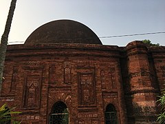
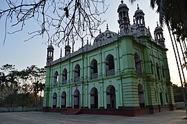
The intense building of mosques which took place during the Sultanate era indicates the rapidity with which the locals converted to Islam. Today, mosques are present in every Muslim-inhabited village. Bengali mosques are normally be covered with several small domes and curved brick roofs decorated with terracotta. Ponds are often located beside a mosque.[26]
Faujdar Farhad Khan built Sylhet Shahi Eidgah in the 1660s under the reign of Mughal Emperor Aurangzeb. It stands as the largest eidgah of the region.[27]
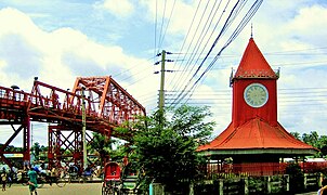
In 1872, Nawab Moulvi Ali Ahmed Khan of Prithimpassa constructed Ali Amjad's Clock, named after his son, in Sylhet City.[28][29][30] In 1936, a bridge was constructed across the Surma River known as the Keane Bridge. These two historic landmarks are known as the gateway to Sylhet city.
Assam-type architecture developed in Sylhet region under Assam Province during the late modern period.
- Architecture of Sylhet
-
-
-
-
 Sylhet Shahi Eidgah entrance
 -
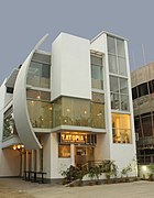 Modern architecture in Sylhet


Sports and games

Cricket is the most popular sport in Sylhet. Regional cricket teams include Sylhet Thunder, East Zone and the Sylhet Division cricket team. Football is also a common sport and the multi-use Saifur Rahman Stadium are known to host football matches. Beanibazar SC has played in the Bangladesh League. The home stadium of the football club, Sheikh Russel KC, is in Sylhet District Stadium. Board and home games such as Dosh Fochish and its modern counterpart Ludo, as well as Carrom Board, Sur-Fulish, Khanamasi and Chess, are very popular in the region. Nowka Bais is a common traditional rowing competition during the monsoon season when rivers are filled up, and much of the land is under water. Fighting sports include Kabaddi, Latim and Lathi khela.
Demography
.jpg)
_Biplob_Rahman.jpg)
The division's population is over 12 million and Bengali Muslims make up a large majority of the region's population. The tribal and Adivasi population tend to live in secluded rural areas of the region primarily near the hills and tea gardens. They are made up of several ethnic groups such as the Bishnupriya Manipuris, Khasi, Lalengs, Tripuris, Meiteis, Garos, and Kukis. In the nineteenth century, the British brought over indigenous peoples from other parts of British India to work as tea garden labourers such as the Kurmis, Musahars, Bauris, Beens, Bonaz and Bhumij amongst others.[31]
Religion
Religion in Sylhet[citation needed]
Islam is the largest religion in the whole region practised by the Bengali Muslims. Sunni Islam is the largest denomination with majority following the Hanafi school of law although some also follow the Shafi'i and Hanbali madhhabs.[32] There are significant numbers of people who follow Sufi ideals similar to the Barelvis, the most influential is the teachings of Abdul Latif of Fultoli, Zakiganj – a descendant of Shah Kamal Quhafa, the son of Burhanuddin Quhafa, one of the disciples of Shah Jalal.[33] The revivalist Deobandi movement is also popular in the region with Jamia Luthfia Anwarul Uloom Hamidnagar being a notable centre and many are part of the Tablighi Jamaat. Other Islamic institutions include the Sujaul Senior Fazil Madrasha, Sagornal Senior Alim Madrasha, Jamia Tawakkulia Renga and Faridpur Jamia Islamia Madrasah. Haji Shariatullah's Faraizi movement was very popular during the British period and Wahhabism is adopted by some upper-class families.[34]
There is a very small minority of Shia Muslims who gather every year during Ashura for the Mourning of Muharram processions. Places of procession include the Prithimpasha Nawab Bari in Kulaura, home to a Shia family, as well as Balaganj, Osmani Nagar and Rajtila.
Hinduism is the second largest religion practised by the Bengali Hindus as well as majority of the Bishnupriya Manipuri, Beens, Bhumij, Bonaz, Musahar, Kurmi, Lalengs, Bauris and Tripuri population. Sylhet has the largest concentration of Hindus in Eastern Bengal and is a part of the Shakti Peetha.
Other minority religions include Christianity (including the Roman Catholic Diocese of Sylhet and Sylhet Presbyterian Synod), Ka Niam Khasi, Sanamahism, Songsarek as well as animism. In the early 20th century, there were over a hundred Marwaris from Rajasthan that were living in Sylhet, mostly as merchants and followed Jainism.[25]: 90
There was a presence of Sikhism in Sylhet after Guru Nanak's visit in 1508 to spread the religion. Kahn Singh Nabha has stated that in memory of Nanak's visit, Gurdwara Sahib Sylhet was established.[35] This Gurdwara was visited twice by Tegh Bahadur and many hukamnamas were issued to this temple by Guru Gobind Singh. In 1897, the gurdwara fell down after the earthquake. Nearly all the Sikhs of Sylhet in the early 18th century were found in North Cachar where they used to work for the Assam Bengal Railway.[36]
In popular culture
- In season 4, episode 6, of Call the Midwife, the midwives tend to a woman from the Sylhet Division.[37]
See also
References
- ^ https://www.wikiloc.com/hiking-trails/kala-pahar-the-highest-peak-of-greater-sylhet-and-northern-bangladesh-11491114
- ^ "Illiteracy curses half in Sylhet". www.daily-bangladesh.com (in Bengali).
- ^ "Article 3. The state language". The Constitution of the People's Republic of Bangladesh. Ministry of Law, The People's Republic of Bangladesh. Retrieved 1 February 2017.
{{cite book}}:|website=ignored (help) - ^ "Sub-national HDI - Area Database - Global Data Lab". hdi.globaldatalab.org. Retrieved 13 September 2018.
- ^ Rabbani, AKM Golam (7 November 2017). "Politics and Literary Activities in the Bengali Language during the Independent Sultanate of Bengal". Dhaka University Journal of Linguistics. 1 (1): 151–166. Retrieved 7 November 2017 – via banglajol.info.
- ^ Rahman, Fazlur (1991). Sileṭer māṭi, Sileṭer mānush. MA Sattar. p. 33.
- ^ "About the name Srihatta". Srihatta.com.bd. Retrieved 7 April 2019.
- ^ Ahmad Hasan Dani (1957). "Analysis of the Inscriptions". Asiatic Society Of Pakistan Vol-ii. p. 111.
- ^ Shofi Ahmed. "'Shelet' (Sylhet) Found in the Bible". Bangla Mirror.
- ^ Abu Musa Mohammad Arif Billah (2012). "Persian". In Sirajul Islam and Ahmed A. Jamal (ed.). Banglapedia: National Encyclopedia of Bangladesh (Second ed.). Asiatic Society of Bangladesh.
- ^ Sylhet City. Bangla2000. Retrieved 28 November 2008.
- ^ Sufia M. Uddin. Constructing Bangladesh: Religion, Ethnicity, and Language in an Islamic Nation. p. 148.
- ^ Hussain, M Sahul (2014). "Jalalabad Thana". Banglapedia: National Encyclopedia of Bangladesh (Second ed.). Asiatic Society of Bangladesh.
- ^ Tanweer Fazal (2013). Minority Nationalisms in South Asia. Routledge. pp. 53–54. ISBN 978-1-317-96647-0.
- ^ "To make (the Province) financially viable, and to accede to demands from professional groups, (the colonial administration) decided in September 1874 to annex the Bengali-speaking and populous district of Sylhet."(Hossain 2018:260)
- ^ " A memorandum of protest against the transfer of Sylhet was submitted to the viceroy on 10 August 1874 by leaders of both the Hindu and Muslim communities." (Hossain 2013:261)
- ^ "It was also decided that education and justice would be administered from Calcutta University and the Calcutta High Court respectively." (Hossain 2013:262)
- ^ "They could also see that the benefits conferred by the tea industry on the province would also prove profitable for them. For example, those who were literate were able to obtain numerous clerical and medical appointments in tea estates, and the demand for rice to feed the tea labourers noticeably augmented its price in Sylhet and Assam enabling the Zaminders (mostly Hindu) to dispose of their produce at a better price than would have been possible had they been obliged to export it to Bengal." (Hossain 2013:262)
- ^ Sylhet, Bangladesh Archived 19 June 2009 at the Wayback Machine.St.Albans District Council.
- ^ Gardner, Katy (July 1992). "International migration and the rural context in Sylhet". New Community. 18 (4): 579–590. doi:10.1080/1369183X.1992.9976331.
- ^ Sajahan Miah (2012). "Sylhet Division". In Sirajul Islam; Miah, Sajahan; Khanam, Mahfuza; Ahmed, Sabbir (eds.). Banglapedia: the National Encyclopedia of Bangladesh (Online ed.). Dhaka, Bangladesh: Banglapedia Trust, Asiatic Society of Bangladesh. ISBN 984-32-0576-6. OCLC 52727562. OL 30677644M. Retrieved 19 October 2024.
- ^ a b c E M Lewis (1868). "Sylhet District". Principal Heads of the History and Statistics of the Dacca Division. Calcutta: Calcutta Central Press Company. pp. 281–326.
- ^ Monthly Averages for Sylhet, BGD MSN Weather. Retrieved 25 May 2009.
- ^ Siddiquee, Iqbal (10 February 2006). "Sylhet growing as a modern urban centre". The Daily Star. Retrieved 25 May 2009.
- ^ a b B C Allen (1905). Assam District Gazetteers. Vol. 2. Calcutta: Government of Assam.
- ^ Oleg Grabar (1989). Muqarnas: An Annual on Islamic Art and Architecture. Brill Archive. pp. 58–72. ISBN 978-90-04-09050-7.
- ^ Ali Ahmad. "Vide". Journal of Assam Research Society. VIH: 26.
- ^ Kadir Jibon, Abdul (11 September 2018). "Ali Amjad's Tower Clock". Daily Sun. Dhaka. Retrieved 17 August 2019.
- ^ Alam, Mahabub (20 July 2016). এখনও সময় জানায় আমজাদের সেই ঘড়ি [Ali Amjad's clock still telling the time!]. Banglanews24.com (in Bengali). Retrieved 18 August 2019.
- ^ Chowdhury, Aftab (5 October 2016). আলী আমজাদের ঘড়ি [The Clock of Ali Amjad]. Bangaldesh Pratidin (in Bengali). Dhaka. Retrieved 18 August 2019.
- ^ Jengcham, Subhash. "Bhumij". Banglapedia: National Encyclopedia of Bangladesh. Asiatic Society of Bangladesh.
- ^ "Islam in Bangladesh". OurBangla. Archived from the original on 19 February 2007. Retrieved 3 August 2016.
- ^ Dr David Garbin (17 June 2005). "Bangladeshi Diaspora in the UK : Some observations on socio-culturaldynamics, religious trends and transnational politics" (PDF). University of Surrey. Archived from the original (PDF) on 23 September 2010. Retrieved 3 June 2008.
- ^ Hunter, William Wilson (1875). "District of Sylhet: Administrative History". A Statistical Account of Assam. Vol. 2.
- ^ "Gurdwaras in Bangladesh". Sikhi Wiki.
- ^ B C Allen (1905). Assam District Gazetteers. Vol. 1: Cachar. Calcutta: Government of Assam.
- ^ "'Call The Midwife' Season 4 Premiere: Nurse Barbara Learns About Culture As Cynthia Returns In Sneak Peek [VIDEO]". ENSTARZ.
External links
Places adjacent to Sylhet Division | ||||||||||||||||
|---|---|---|---|---|---|---|---|---|---|---|---|---|---|---|---|---|
| ||||||||||||||||


| Barisal Division |  | |
|---|---|---|
| Chittagong Division | ||
| Dhaka Division | ||
| Khulna Division | ||
| Mymensingh Division | ||
| Rajshahi Division | ||
| Rangpur Division | ||
| Sylhet Division | ||