
Angers
Angers | |
|---|---|
 | |
 Coat of arms | |
Location of Angers  | |
| Country | France |
| Region | Pays de la Loire |
| Department | Maine-et-Loire |
| Arrondissement | Angers |
| Canton | Chef-lieu of eight cantons |
| Intercommunality | Angers Loire Métropole |
| Government | |
| • Mayor (2012–2014) | Frédéric Béatse (PS) |
| Area 1 | 42.70 km2 (16.49 sq mi) |
| • Urban | 188.6 km2 (72.8 sq mi) |
| • Metro | 2,353.8 km2 (908.8 sq mi) |
| Population (2009[1]) | 147,305 |
| • Rank | 18th in France |
| • Density | 3,400/km2 (8,900/sq mi) |
| • Urban (2009) | 215,132 |
| • Urban density | 1,100/km2 (3,000/sq mi) |
| • Metro (2009) | 394,710 |
| • Metro density | 170/km2 (430/sq mi) |
| Time zone | UTC+01:00 (CET) |
| • Summer (DST) | UTC+02:00 (CEST) |
| INSEE/Postal code | 49007 /49000, 49100 |
| Elevation | 12–64 m (39–210 ft) |
| Website | www.angers.fr |
| 1 French Land Register data, which excludes lakes, ponds, glaciers > 1 km2 (0.386 sq mi or 247 acres) and river estuaries. | |
Angers ([ɑ̃.ʒe] )) is a city in western France, about 300 km (190 mi) southwest of Paris, and the chef-lieu of the Maine-et-Loire department. Angers was before the French Revolution the capital of the province of Anjou, and inhabitants of both the city and the province are called Angevins. The commune of Angers proper, without the metropolitan area, is the third most populated in northwestern France after Nantes and Rennes and the eighteenth in France.[2]
Angers is the historical capital of Anjou and was for centuries an important stronghold in northwestern France. It is the cradle of the Plantagenêts dynasty and was during the reign of René of Anjou one of the intellectual centres of Europe. Angers developed itself at the convergence point of three rivers, the Mayenne, Sarthe and Loir, all coming from the north and flowing south to the Loire. Their convergence, just north of Angers, creates the Maine, a short but wide river that flows into the Loire several kilometers south. The Angers metropolitan area is a major economic centre in western France, particularly active in the industrial sector, horticulture and business tourism.[3]
Angers proper covers 42.70 km²[4] and has a population of 147,300 inhabitants, while c. 394,700 live in its metropolitan area. Angers is the centre of an agglomeration community, Angers Loire Métropole, made up of 33 communes covering 540 km² and 287,000 inhabitants.
Angers enjoys a rich cultural life, made possible by its universities and museums. The old medieval centre is still dominated by the massive château of the Plantagenêts, home of the Apocalypse Tapestry, the biggest medieval tapestry ensemble in the World. Angers is also both at the edge of the Val de Loire, a World Heritage Site, and the Loire-Anjou-Touraine regional natural park.
Toponymy
Name origin

The city is first mentionned by Ptolemy around 150 AD in his Geography. It is then called Juliomagus (written Ιουλιομαγος in ancient Greek).[5][6] The city appears again on the Tabula Peutingeriana, under the name of Iuliomago.
The antique name of Angers, Juliomagus, is composed of Julius, probably a dedication to Julius Caesar, and of the Celtic word magos, which means "market". Similar town dedications were common in Roman Gaul, and toponyms often kept a Gallic element.[7] Later, the determinant Andecavorum was often added to the name, which thus became Juliomagus Andecavorum. Andecavorum refers to the Andecavi, the Gallic people that lived in and around the city.[8]
Andecavorum finally gave to the city its current name. Around 400 AD, the primitive form, Juliomagus, is replaced by the term civitas, forming civitas Andecavorum, a common change in Gaul also visible in the names of Paris, Tours or Évreux which then started to use the name of the local Gallic tribes.[9]
During the Middle Ages, Angers is successively mentioned as Andecava civitas (6th century), Andecavis (769 AD),[10] Andegavis (between 861 and 882), Angieus (in 1127) and Angeus (in 1205). The form Angiers appears during the 12th century,[11] and is later corrupted in Angers. The final -s is a trace of the Latin ablative-locative cases.
Andecavum gave also the name Anjou, which designates the province where Angers is. This double formation is quite common in France, for example with Poitiers/Poitou and Bourges/Berry.
Nicknames
Angers bears several nicknames:
- "Athènes de l’Ouest" (Western Athens), a nickname from the 19th century, inspired by the university, colleges and cultural circles;[12]
- "Ville des fleurs" (City of Flowers), a nickname from the Second French Empire (1852-1870);[13]
- "Ville verte" (Green City), in reference of the numerous parks and the horticulture tradition;
- "Angers la Blanche" (Angers the White), because of its tufa facades, or "Angers la Noire" (Angers the Black) because of its slate rooves.[14]
Geography
Location

Angers in located at the geographical centre of the Maine-et-Loire department, on the road which connects Paris to the Atlantic ocean. The city is situated just south of the confluence of the Loir, Mayenne and Sarthe which form together the river Maine. The Maine crosses Angers and heads south towards the Loire. The confluence of the three rivers and the proximity of the Loire make up a natural crossroads which favoured the foundation of the antique Juliomagus.
Angers is distant 91 km from Nantes, 124 km from Rennes, 132 km from Poitiers and 297 km from Paris. It is also 118 km far from Pornic, the closest sea resort, situated on the Atlantic ocean.
Elevation varies between 12 and 64 meters above sea level.[15] Angers is in fact a hilly town, marked by a rocky promontory dominating the lower valleys of Anjou. The antique city was founded on this promontory and it is where stand today the castle, the cathedral and the medieval quarters.
At the north and south, where the river Maine arrives in and leaves Angers, the landscape is formed by islands, ponds and floodplains which are a haven for birds and a typical flora of the Val de Loire. The étang Saint-Nicolas and Lac de Maine, both artificial, are among the biggest green areas of the city.
Metropolitan area
The commune of Angers is bordered by ten other communes which form various suburbs. These are, clockwise, Avrillé, Cantenay-Épinard, Écouflant, Saint-Barthélemy-d'Anjou, Trélazé, Les Ponts-de-Cé, Sainte-Gemmes-sur-Loire, Bouchemaine and Beaucouzé. 22 other communes situated farther form with them the agglomeration community of the Angers Loire Métropole. All these peripheral communes are situated within 17 km from Angers proper. They unite together c. 272,400 inhabitants.
Climate
Angers enjoys a very mild climate because of its location between oceanic and continental climate. Winters are usually wet, with scarce frosts and snowfalls, and summers are warm and sunny.
| Mois | Jan | Feb | Mar | Apr | May | Jun | Jul | Aug | Sept | Oct | Nov | Dec | Year |
|---|---|---|---|---|---|---|---|---|---|---|---|---|---|
| Average high (°C) | 7,9 | 9,2 | 12,6 | 15,3 | 19 | 22,6 | 24,9 | 24,7 | 21,8 | 17 | 11,4 | 8,4 | 16,2 |
| Average low (°C) | 2,1 | 2,2 | 3,9 | 5,6 | 8,9 | 11,8 | 13,6 | 13,4 | 11,3 | 8,4 | 4,6 | 2,8 | 7,4 |
| Average (°C) | 5 | 5,7 | 8,2 | 10,4 | 13,9 | 16,2 | 19,2 | 19,1 | 16,5 | 12,7 | 8 | 5,6 | 11,8 |
| Precipitation (mm) | 62,1 | 50,8 | 51,7 | 44,6 | 54,4 | 41,2 | 43,8 | 44,9 | 52,2 | 59,6 | 64,5 | 63,4 | 633,4 |
| Sunny hours per month | 70 | 92 | 141 | 179 | 201 | 234 | 248 | 237 | 191 | 129 | 89 | 65 | 1877 |
| Source: Climatology from 1947 to 2008 - Angers, France | |||||||||||||
Urban morphology

The oldest streets and buildings in Angers are located on the promontory where the castle stands. The urban structure there dates back from the 13th, 14th and 15th centuries.[16] A military presence there has been attested since the 3rd century[17] and some remains of an antique city wall are still visible in the castle grounds[18] This wall was built to protect the city from the Germanic invasions of 275-276 AD.
The Castle was during the Middle Ages the core of the city defense system, composed of tall city walls and river chains to prevent enemy ships from going up the Maine. The walls where last reconstructed between 1230 and 1240, on an order of Louis IX of France.[19] Today, portions of wall are still visible in Rue Toussaint and Boulevard Carnot, as well as some towers, like the Tour Villebon and the Tour des Anglais.
Before the first cadastre (1810), the city had maintained much of its medieval limits: on and around the castle promontory, with some dwellings on the other bank of the Maine, a quarter called La Doutre. That part of the city experienced a quick development during the industrial revolution and became a big river port. Industry was encouraged by firms like Bessonneau (textile factories) and Cointreau (distillery). After 1850, many suburbs appeared around the train stations and the farther slate quarries in Trélazé. Despite the port in La Doutre, demographic growth and urban extension were still more important on the eastern bank of the Maine, on which the antique Juliomagus was founded.
The medieval city centre was redeveloped and expanded from 1791. The Place du Ralliement, the main square, is then built in place of three churches destroyed during the French Revolution and, later, ring boulevards planted with trees replaced the city walls. The architectural style used is mainly Haussmanian, but leaves sometimes room for Palladian, Art Nouveau or Art Deco buildings.
After 1945 and the Second World War, several large council estates made of tower blocks are built around the city centre, the first of them being Belle-Beille in 1953. The industrial activities drastically changed; the port activity declined whereas new factories, such as Technicolor SA in 1957, emerged. During the 1970's, the modernist approach on urban extension is replaced by a more individualistic point of view and more and more detached houses are built for the middle class. The metropolitan area keeps enlarging, commuting is generalised and new shopping areas are constructed close to the former villages engulfed by the city. Because of the floodplains that surround the city north and south, Angers can only grow significantly on an east-west axis.
-
 The Tour des Anglais, a remain of the medieval city walls
 -
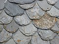 Traditional slated roof
 -
 Half-timbered houses in rue de l'Oisellerie
 -
 View of La Doutre; the industrial port has become a marina
 -
 The Place du Ralliement
 -
 A department store on a 19th century street
 -
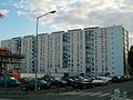 A council estate in La Roseraie
.jpg)


.jpg)

Green areas

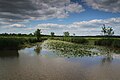
Being both at the edge of the Val de Loire World Heritage site and on the largest river confluence in France,[20] Angers has a high natural potential, notably highlighted by the Saint-Aubin island, situated north of the centre and covering a tenth of the city total surface. Protected, the island is formed of swamps and natural meadows.
The oldest green areas date back from the Renaissance, when the moats of the castle are transformed into pleasure and kitchen gardens. Similar gardens are built by the aristocracy around their hôtels particuliers and medicinal gardens are planted in hospices cloisters. The Jardin des plantes, the first botanical garden, dates back from the beginning of the 18th century. During the 19th century, other ones are built, for example the Faculty of Pharmacy garden and the Roseraie. The first recreational parks, for their part, where built during the Second French Empire. The étang Saint-Nicolas, made by a sluice on a small river, the Brionneau, is protected as soon as in 1936.
The Jardin du Mail (Mall Garden), an esplanade situated outside the ring boulevards, was built between 1820 and 1880 on the former Champs de Mars (Fields of Mars, a place where the garrisons used to train and parade). Another esplanade, the Mail François Mitterrand, was built in 1999 together with a garden inside the new Saint-Serge business district. At last, during the 1960's, the old gravel pits around the Maine were filled with water to form the Lac de Maine, which now hosts a nautical centre. In 2010, a large amusement park, Terra Botanica, was inaugurated close to the Saint-Aubin islande.
-
 The Saint-Aubin island protected area
 -
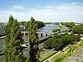 Planted quays around the river Maine
 -
 Jardin du Mail
 -
 Sunset on the Lac de Maine
 -


History
Heraldry

The coat of arms of Angers bears the fleur de lys of the counts and dukes of Anjou; the key evokes the stonghold position of the city close to the Breton border. An acrostic from the Middle Ages calls it "Antique clef de France", which means "Antique key to France":
- Antique clef de France, (antique key to France)
- Necteté de souffrance, (sharpness of displeasure)
- Garant contre ennemys, (guarantor against enemies)
- Estappe d’asseurance, (step of assurance)
- Recours de secourance, (help of relief)
- Seccurité d’amys. (security from friends)
Under Napoleon I's rule, Angers was one of the "Bonnes villes" and was therefore allowed to ask for a new coat of arms. The bees, symbol of the First French Empire, then replaced the royal fleurs de lys.
In 1949, Angers received the 1939–1945 War Cross and since then, the decoration is sometimes placed between the two fleurs de lys.[21]
Angers also had several mottos through its history:[22]
- During Antiquity: Assiuis conciliis (or consiliis);
- From 1434 to 1480 (reign of René of Anjou): D’ardent désir;
- In 1499: Antique clef de France;
- Until June 1987: Angers, la qualité.
Prehistory and Antiquity

The first sign of human presence in Angers dates back to 400,000 BC. Vestiges from the Neolithic are more abundant and include numerous polished stone axes. Burials from 4,500/3,500 BC were also discovered in the actual castle grounds.
During the 5th century, the Andecavi, a Celtic people, settles north of the Loire. By the end of the Age of Iron, Angers is a relatively densely populated oppidum. The name Juliomagus, might it be more ancient, is not attested before the 3rd century AD. The Roman town consisted of many villas, baths and had an amphitheatre as well as a temple dedicated to Mithra.
Successive Germanic invasions in 275 and 276 forced the inhabitants to move on the highest point of their city and to build a wall around a small area of around 9 hectares.
Middle Ages

Angers gets its first bishop in 372, during the election of Martin of Tours. The first abbey, Saint-Aubin, is built during the 7th century to house the sarcophagus of Saint Albinius. Saint-Serge abbey is founded by the Merovingian kings Clovis II and Theuderic III a century later. In 2008, ten sarcophagi were discovered where Saint-Morille church once stood during the tramway construction.[23]
From the 850s, Angers suffers from its situation on the border with Brittany and Normandy. In September 851, Charles the Bald and Erispoe, a Breton chief, meet in the town to sign the Treaty of Angers, which secures the Breton independance and fixes the borders of Brittany. However, the situation remains dangerous for Angers, and Charles the Bald creates in 853 a wide buffer zone around Brittany comprising parts of Anjou, Touraine, Maine and Sées, which is ruled by Robert the Strong, a great-grandfather of Hugh Capet.
In 870, the Viking chief Hastein seizes Angers where he settles, but quickly surrounds after a siege. He takes again control of the town in 873,[24] before being ousted by the Carolingian Emperor.

Fulk I of Anjou, a Carolingian descendant, is, first, viscount of Angers (before 898 until 830) and of Tours (898-909), and count of Nantes (909-919). Around 929, he takes the title of count of Angers and founds the first Anjou dynasty.
During the 12th century, after internal divisions in Brittany, the county of Nantes is annexed by Anjou. Henry II Plantagenêt keeps it for more than 30 years. At the same time, he also rules the vast Angevin Empire, which stretched from the Pyrenees to Ireland. The [[Château d'Ange[25]rs|castle in Angers]] is then the seat of the Court and the dynasty. The Empire disappeared in 1204-1205 when the the King of France, Philip II, seized Normandy and Anjou.
Henceforth a part of the Kingdom of France, Angers becomes the "Clé du Royaume" (Key to the Kingdom) facing independent Brittany. In 1228, during Louis IX's minority, Blanche of Castile decides to fortify the city and to rebuild the castle. Later, during the 1350s and 1360s, the schools of Law, Medicine and Theology, renowned in the whole Europe, are organised in a university. In 1373, Louis I of Naples and Anjou orders the six tapestries illustrating the Apocalypse of St John known today as the Apocalypse Tapestry.
Renaissance

Le roi René d'Anjou contributed to the economic revival in a city that had been diminished by the Black Death (1347-1350) and the Hundred Years War (1337-1453). A man of great culture and generosity, René transformed Angers into a cultural and politic centre and held there a brilliant Court. He transformed the castle moat into a menagerie and built several gardens. He also founded in Angers a new Ordre du Croissant which was supposed to compete with the Order of the Golden Fleece, created several years before.
In 1474, Louis XI of France, who wants to seize Anjou, comes to Angers with his army, asking for the keys of the city.[26] René, then 65 years old, doesn't want to lead a war against his nephew and surrender his domains without any fight. Thus, Anjou ceased to be an appanage and felt definitely into the Royal domain. After his dead, René is buried in 1480 in Saint-Maurice cathedral.
.jpg)
In 1551, Angers becomes the seat of a bailiwick and the présidial of a jurisdiction, a position the city keeps until 1790. At the same time, with the growth of Protestantism in France, a Catholic is placed at the head of the city and its castle while the bourgeoisie forms a Catholic militia to protect Angers from the Huguenots. The bishop, Gabriel Bouvery, organises on his side an "Angevine League".
When the news of St. Bartholomew's Day massacre arrive in Angers, a new massacre is organised in the city. The bodies of killed Protestants are thrown in the Mayenne. It is the aldermen who stop the slaughter.[27]
In 1598, the Edict of Nantes is prepared in Angers by Henri IV. From the 6th of March until the 2th of April, Angers is de facto the capital of France and the King tries by all means to satisfy the Catholics of the city, for example by founding the new Couvent des Capucins.
Ancien Régime
In 1611, Louis XIII of France gives the governance of Anjou to his mother, Marie de' Medici. The Queen mother settles in Angers, at the Logis Barrault, with her chaplain, Cardinal Richelieu.
At the premature death of Louis XIII, his son Louis XIV is only an infant and France is troubled by several famines and epidemics and by politic instability. In 1649, the people of Angers launch a revolt against rising taxes, a movement that started the Fronde in Anjou. The Fronde was a nationwide military conflict opposing some aristocrats favoring a less autocratic regime to the Royal forces held by Anne of Austria, Queen mother and regent, and her prime minister, Cardinal Mazarin. The Royal repression in Angers is narrowly avoided by the bishop Henri Arnauld, who intercedes with the Queen mother. Bishop of Angers until 1692, Arnauld deeply marked the religious life of the city during the second half of the 17th century.
In 1652, Henri Chabot, Duke of Rohan and governor of Anjou, decides to back Louis of Condé, chief of the Fronde. Angers becomes again a rebellious city and Louis XIV sends his army to seize it. The Duke of Rohan immediately surrenders and thus avoids the sack of the city.
French Revolution

The first months of the French Revolution are relatively quiet in Angers. In 1789, the city looses its ancient administrative positions, replaced in 1790 by the department of Mayenne-et-Loire, soon renamed "Maine-et-Loire". Anjou, as a political entity, disapears, although the new departement includes most of its territory.
The War of Vendée, a Royalist rebellion and counterrevolution led in Vendée, a department located at the southwest of Maine-et-Loire, reached the Loire in March 1793. The Royalist army soon crosses the river and goes as far as Granville, in Normandy, in November. Pushed back, the Vendéens go back south and, to cross the Loire again, have to attack Angers.
The city is defended by 4,000 Republican soldiers, whereas the Royalists are at least 20,000, but weakened by successive fights and deceases. The Siege of Angers occurs the 3rd and 4th of December 1793. The Royalists' bad tactic, as well as the strength of Angers city wall and castle, cause their loss. They consequently go back north for a while, around Le Mans, before eventually crossing the Loire in Ancenis the 16th of December.
In 1794, a fierce repression is conduced in the whole region against the Royalists. In Angers, 290 prisoners are shot and 1020 others die of illness in jail.[28] The city also welcomed many refugees, mostly Republicans living in the Royalist areas. Between the 19th and the 31st of May 1793, between 650 and 1000 Republican families seek asylium in Angers.[29]
Since 1800
.jpg)
During the 19th century, the city is deeply influenced by the urban transformations in Paris. Many quartiers are destroyed, redeveloped or rebuilt. The city wall, which formed a square around the old city core, is demolished around 1850 and replaced by wide boulevards. In 1849, the railway Angers-Saumur is built and extended to Nantes two years later. When completed, the line connected Paris to the Atlantic coast.
In 1850 a catastrophic failure of the Basse-Chaîne suspension bridge caused the deaths of over 200 soldiers. The disaster inhibited the construction of suspension bridges in France for two decades. The accident was mainly caused by soldiers' lilting walking which created resonance in the bridge structure.[30]
In 1875, a free faculty is created and soon assimilated to the medieval Universitas Andegavensis, which was dissolved during the French Revolution. The new faculty is canonically erected as a Catholic university by the Pope Pius IX in 1879. However, in 1890, a law prohibits private institutions of higher education to call themselves "university", and it is officially renamed in Faculté libre d'Angers (Free Faculty of Angers), although it informally kept its original name, 'Université catholique d'Angers. At the beginning of the 20th century, two higher education establishments, specialised in agriculture and commercial sciences, are opened.

During the first half of the 20th century, several Art Nouveau and Art Deco buildings are constructed, such as the Nouvelles Galeries, the Hotel des Postes, Hotel Continental, the Alcazar or the Maison bleue.
In September 1939, when Poland is invaded by Germany, the Polish government-in-exile settles in Angers. It left the city the 12th of June 1940, after the invasion of France by the Wehrmacht. Angers falls to the Nazis during the same month. The Germans make it the seat of a regional Kommandantur. In 1941, a first Resistance movement, called Honneur et Patrie, is created in Angers.60 Resistants are shot at Belle-Beille range in 1942 and a German bunker factory employs 6000 people in 1943.[31] In July 1942, 853 Jews are arrested and sent to Auschwitz.[32]
The night of the 28th May 1944 occurs the first Allied bombing over the Saint-Laud quarter. 243 people die and many others are wounded. Successive attacks the 29th and 30th of May destroy the train station and its surroundings[33] which are reconstructed in the 1950's.
After liberating Avranches and Rennes, General Patton and his 5th infantry division arrive in Anjou the 5th of August. To seize Angers, they decide to enter the city by its eastern side to surprise the Nazis. The 9th of August, they cross the Maine and start the fight. Helped by the local French Forces of the Interior, they progressively move forward the city centre. The fight is nevertheless difficult and Angers is liberated the day after, at around 5 p.m.[34]
After the end of the war, the city experiences a quick development and demographic growth. In 1971, a decision is made to reestablish a public university, and the Université catholique d'Angers is split between the Université catholique de l'Ouest, private, and the Université d'Angers, public. Angers has had since then two different universities.
Until the 1980's, Angers experienced as well several massive urban plans, such as the construction of the Lac de Maine, of several vast council estates and shopping malls, as well as the construction of a highway which crosses the city by its centre, a project that forced the destruction of many old buildings and destroyed the original quays on the Maine. Later, other urban plans were dawned, but with a new emphasis on nature and heritage protection, as well as on social mix. Conduced during the 1990's, the redevelopment of the Saint-Serge quarter, located just north of the historical centre, left a new business centre, gardens and university buildings.
Administration
.jpg)
Angers received its communal charter from Louis XI of France in February 1475, but free elections for the mayor and aldermen were not garanteed before 1484, following a decision by Charles VIII. Since then, 75 successive mayors have been governing Angers.
Angers was until the Second World War mainly governed by centrist and republican mayors. Since 1977, all the successive mayors have been members of the Socialist Party, whereas the Maine-et-Loire department has always been governed by moderate right-wing parties. Following Jean-Claude Antonini's resignation in 2012, the current mayor is Frédéric Béatse.
Angers is divided into height cantons, most of them gather parts of Angers plus some surrounding communes. These cantons are not administrative entities and only serve to elect the members of the department council. The INSEE, the French institute for statistics, divides on its side the commune of Angers into twelve sectors. Depending of their social and economic issues, some of them can have priority for financial assistance and urban regeneration. In Angers, five are considered as priority sectors, three as sensitive urban areas, and one is a urban free zone.
Being the chef-lieu of Maine-et-Loire, Angers is the seat of a prefecture. It is also the seat of an appeal court and of several regional or local institutes, concerning for example the customs, education or science. Angers also has several other courts of justice as well as a prison.
Demographics
| Year | Pop. | ±% |
|---|---|---|
| 1793 | 33,900 | — |
| 1821 | 29,873 | −11.9% |
| 1841 | 39,884 | +33.5% |
| 1861 | 51,797 | +29.9% |
| 1881 | 68,049 | +31.4% |
| 1901 | 82,398 | +21.1% |
| 1921 | 86,260 | +4.7% |
| 1946 | 94,408 | +9.4% |
| 1962 | 115,252 | +22.1% |
| 1975 | 137,591 | +19.4% |
| 1990 | 141,404 | +2.8% |
| 2009 | 147,305 | +4.2% |
| Source:Base Cassini from EHESS for figures until 1962[35][36][37][38] | ||
In 2009, Angers had 147,305 inhabitants, 0.3% less than ten years before.[39] It is the 18th most populated commune in France and it reached its maximum population in 2006, with 152,337 inhabitants. Censuses have been conduced since 1793.
In 2009, the urban area, which encompasses Angers plus nine surrounding communes (188.6 km² in total), had 215,132 inhabitants.[40] The metropolitan area was on its side encompassing in 2009 133 communes, 394,710 inhabitants and 2,353.8 km².[41] The Angers Loire Métropole, an economic and political association of communes, gathers 33 communes and around 272,000 inhabitants.[42]
The population of Angers is relatively young, 48% of the population being younger than 30 and the rate of people over 60 years old (18.9%) being lower than both the national (22.1%) and departemental (21.4%) rates.[43] This is partially explained by the presence of two universities, 21.3% of the population being pupils and students in 2009.[44]
Economy

The early prosperity of the town is largely due to the nearby quarries of slate, whose abundant use for the roofs of Angers led to the city's nickname, the "Black City" (or "La ville noire", in French). As of 1911, existing industries noted in the Encyclopædia Britannica for that year included the distillation of liqueurs from fruit (Cointreau, a brand of triple sec orange liqueur, is produced to this day in Saint-Barthélemy-d'Anjou, a commune in Angers urban area); cable, rope, and thread-making; the manufacture of boots, shoes, umbrellas, and parasols; weaving of sail-cloth and fabrics; machine construction; wire-drawing; and the manufacture of sparkling wines and preserved fruits. The chief articles of commerce, besides slate and manufactured goods, were hemp, early vegetables, fruit, flowers, and live-stock.
Many of these industries present in 1911 have since disappeared, though Cointreau continues to produce liqueur. Other contemporary industries include the manufacturing of lorries (Scania) and computers (Bull, Packard Bell, NEC) as well as research in horticulture and biotechnologies. Angers economy is also tributary to the presence of many administrative, educational and health institutions, and is also characterised by a great number of small firms, often oriented towards the agricultural tradition of Maine-et-Loire. Thanks to its several higher education schools, laboratories, and various offices, Angers is the largest horticultural centre in Europe.[45]. It is as well a regional finance centre, with many banks and insurance companies having a regional seat there (Afone, CNP Assurances, Crédit agricole, Fiducial, Groupama...).
Angers is an important congress and fair centre. The congress activity gives each year a fallout of eight millions euros to the local commerce and a new congress centre should replace the current one by 2016, doubling this economic fallout.[46] The Parc des Expositions, where fairs are held, welcomes 600,000 visitors and more than 300 events each year. With its 27,000 m², it is the biggest infrastructure of that type in northwestern France.[47]
Angers provides 45,7% of the Maine-et-Loire job positions. It is the 22nd national job provider and the 3rd one in northwestern France after Nantes and Rennes. Its unemployment rate, 9.9% in 2009, is close to the national rate. 21.4% of the people working in Angers have graduate or post-graduate qualifications.[48]
Health and education

The Hôtel-Dieu, founded in the 12th century, is one of the oldest hospitals in France. First located in the Hospice Saint-Jean, it moved in new buildings in 1870. In 2000, a university hospital was opened north of the city centre. It contains 1,500 beds and around 5,500 people work there.[49] Two private hospitals and a regional centre for reeducation also exist.
A centre of learning, Angers boasts two renowned universities and several specialized institutions, altogether responsible for more than 26,000 students.[50] The city has a Catholic university, the Université Catholique de L'Ouest (Catholic University of the West, or UCO), one of five Catholic universities in France. UCO is best known for its French language studies institute, the Centre international d'étude de la langue française (CIDEF), which provides college students from around the world with college-level course instruction in the French language. The town is also home to a state university, the University of Angers.
Angers's other educational institutions include lycées; training colleges, an engineering school in manufacturing (ENSAM), an engineering school in electronics and computer science (ESEO), and a school of fine art. Its education and research institutes are the driving force behind the city's science and technology industries.
Angers's Business School is ESSCA (Ecole Superieure des Sciences Commerciales d'Angers). Formerly part of the UCO, the school's Masters program is of a duration of five years. ESSCA is recruiting students after the Baccalaureat.
In addition to French schools and universities, an American university St. Edward's University has a new expanding campus in Angers. St. Edward’s University is a diverse, Catholic liberal arts institution from Austin, Texas. The university has a partnership with UCO, and offers a variety of courses of undergraduate level and professional training.
Transport

Angers is situated on the crossroads of three highways, the A11, to Paris and Nantes, the A87 to La Roche-sur-Yon and the A85 to Tours and Lyon. National roads connect the city with Rennes, Caen and Laval.
Before the construction of bypasses during the 2000's, the A11 was crossing the city centre, following the river Maine and passing just down the castle. Occasionning air pollution, noise and disfiguring the Maine quays, the portion of former highway, still in place, should be redeveloped in the following years.
Angers inaugurated a new tram system on 25 June 2011. The tramway consists of one 12 km (7.46 mi) line with 25 stops. The line runs from Avrillé-Ardenne in the north to Angers-Roseraie in the south, passing by the centre and the train station. Service is provided by Keolis using 17 Alstom Citadis trams.[51] The system uses partial ground-level power supply, which avoids aerial wires and preserve the historical character of the city centre. A second line is scheduled for 2018-2022. The public transportation company, Trigo, which operates the tram, also organises the bus network composed of 13 urban lines and 12 suburban lines.
The bus station, situated outside the Angers Saint-Laud train station, is a hub for the departmental bus network (Anjoubus) and is also served by international bus companies.
Angers is on both Nantes-Paris and Nantes-Lyon railways. The city has several train stations, all first built in the 19th century. Some are still in use, others are closed or reserved for the freight. The main station, Angers Saint-Laud, is on a TGV line and has a direct TGV service to Paris (1 hour 30 minutes), Lyon (3 hours 45 minutes), Strasbourg (4 hours 35 minutes), Lille (3 hours 25 minutes) as well as Avignon, Marseilles and Montpellier. Regional trains go to Cholet, Saumur, Tours, Blois, Nevers or Bourges.
The nearest airport is Angers - Loire Airport, which replaced in 1998 an older infrastructure near the Saint-Aubin island. The Angers - Loire Airport is located on the commune of Marcé, 20 km from Angers and close to the A11 and the A85. It can receive 50,000 passengers per year.
Culture
Main sights

The Château d'Angers, built on a schist promontory, dominates the river Maine and the old town. Its site has been occupied since Antiquity and the actual castle was built between 1230 and 1240 by Louis IX of France. The massive walls are about one kilometer long and punctuated by 17 towers; they were built with horizontal slices of tuf and schist, giving it strenght and an original striped look. During the 15th century, a chapel and the Châtelet were added in the courtyard.
The Maison d'Adam (Adam's House), located behind the cathedral, is an excellent example of the half-timbered houses which were built during the Middle Ages. Many similar houses, although smaller, are also visible along the streets around the castle. The city also displays several Renaissance and classical hôtels particuliers, the most renowned being the Logis Pincé from the 16th century. The Maison bleue (Blue House), built in 1927, is on its side an Art Deco masterpiece. The former seat of the Compagnie française d'Aviation was built in 1938 and abandoned during the Second World War. Totally refurbished in 2004, it is now a testimony of the 1930's architecture.
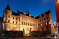
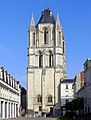
The Saint-Maurice cathedral is a major landmark in the cityscape, with its two spires culminating at 75 meters. The construction of the current building started during the 12th century on the remains of an older sanctuary. The original structure, romanesque, received gothic columns and vaults in the middle of the 13th century, giving birth to the Angevine gothic, a style that quickly spread in Western France and the Angevine possessions in Italy. Sculptures and architectural details were added on the facade during the 16th century. The twin spires were built in 1518 and 1523. The neighbouring Palais du Tau, the former episcopal palace, dates from the 12th century.
The skyline is also marked by the Tour Saint-Aubin. Completed in 1170, it was the bell-tower of an abbey closed during the French Revolution and destroyed in 1810. Elaborately sculptured 11th and 12th century arcades also survive in the courtyard of the Prefecture.[52] Another abbey, the Abbaye Toussaint, founded during the 13th century, was also partially pulled down and only the church and parts of the cloister are still visible. On the southern limits of the commune, close to the Maine, stands the Couvent de la Baumette, founded during the 15th century by René of Anjou.
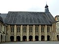
La Doutre, an old quarter located on the western bank of the Maine and facing the castle, contains two major medieval sites, the former Abbaye du Ronceray, built during the 11th and 12th century, and the Hôpital Saint-Jean, founded by Henry II of England and used as the city hospital until 1870.
-
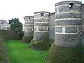 The distinctive striped towers of the castle
 -
 The castle
 -
 The Châtelet in the castle
 -
 Maison Poisson
 -
 Maison du Croissant
 -
 Logis Pincé
 -
 The "Maison bleue"
 -
 The cathedral
 -
 Inside the cathedral
 -
 Palais du Tau
 -
 Tour Saint-Aubin
 -
 Abbaye du Ronceray


Museums

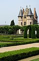
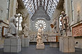
The Musée des Beaux-Arts d'Angers, located in the Renaissance Logis Barrault, displays a collection of paintings and scultures dating from the 14th century to today. It is particularly renowned for its 18th century paintings, including works by Jean-Baptiste Greuze, Van Loo, Antoine Watteau, Jean-Honoré Fragonard and Jean Siméon Chardin. The museum also contains a graphic design studio, a gallery devoted to the history of Angers and a temporary exhibition gallery. The institution has an antenna at the château in Villevêque, a village located several kilometers north of the city.
Inside the castle, a special gallery displays the Apocalypse Tapestry, ordered by Louis I of Naples at the end of the 14th century. It is more than 140 meters long, and thus, the biggest medieval tapestry in the World. Inspired by manuscript miniatures, the successive scenes, designed by Jean Bondol, illustrate the Apocalypse of St John.
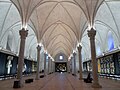
Located inside the old Hôpital Saint-Jean, the Musée Jean-Lurçat et de la tapisserie contemporaine displays tapestries dating from the 19th and 20th centuries. The museum is dedicated to Jean Lurçat, an artist noted for his role in the revival of contemporary tapestry, and notably exhibits his "Chant du Monde", a modern echo to the Apocalypse Tapestry made after the bombing of Hiroshima.
The Muséum d'histoire naturelle d’Angers has been located in the 1521 Hôtel Demarie-Valentin since 1885. It exhibits a large collection of stuffed animals and fossils, divided in three departments, one for zoology, one for botanics and the last one for paleontology and geology.
The Logis Pincé, constructed during the Renaissance, is the home of the museum of the same name. It displays Egyptian, Greek, Roman and Etruscan antiquities as well as Chinese and Japanese artifacts.
Located in the Abbaye Toussaint, the Galerie David d'Angers gathers sculptures, reliefs, medallions by David d'Angers, a 19th century sculptor born in the city. The gallery owns as well the preparatory works for the Panthéon of Paris pediment.
Angers also enjoys a Maison de l'Architecture, which organises various exhibitions and workshops, as well as several temporary exhibition galleries distributed in the city centre. Outside the commune limits are also an aviation museum and a museum of communications.
-
 The Musée des Beaux-Arts
 -
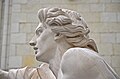
 Les Génies des Arts by François Boucher, at the Musée des Beaux-Arts
 -
 Italian drawing, 17th century, at the Musée des Beaux-Arts
 -
 Musée Jean-Lurçat
 -
 Galerie David d'Angers
 -
 Galerie David d'Angers


.JPG)
.jpg)

Entertainment and performing arts

The Grand Théâtre, dominating the Place du Ralliement, was first built in 1791, but destoyed by a fire in 1853. The actual building was completed in 1871 and its auditorium contains six stall and four balconies, totalising 730 seats. The Théâtre du Quai, inaugurated in 2007, has on its side two auditoriums, one contains 980 seats and several balconies, and the other, more flexible, can welcome 400 seating or 960 standing sepctators. The Grand Théâtre and the Théâtre du Quai are the venues of three institutions, Angers-Nantes Opéra, an opera company also based in Nantes, the Contemporary Dance National Centre (CNDC), inaugurated by Alwin Nikolais in 1978, and the Nouveau théâtre d'Angers (NTA).
The Orchestre National des Pays de la Loire, shared with Nantes, usually performs at the Congress Centre, built during the 1960's and with a capacity of 1,240 seats. Other concert halls include the Chabada, the Amphitéa and the former Ursuline chapel. Local theatre companies perform at Théâtre Chanzy, Théâtre du Champ de Bataille, Théâtre de la Comédie or at the Centre Jean Vilar. Each September, the city organises a street performance festival, called the Accroche-Cœurs.
The Chabada, a popular concert hall, is the cradle of the Angevine contemporary scene and several groups and performers were discovered there, Les Thugs, a punk band formed in 1983, being the first ones. The local scene also include the alternative rock group La Ruda, the power pop band Pony Pony Run Run, the world music band Lo'Jo and Titi Robin, a performer influenced by Gypsy and Arabic music.
The Premiers Plans festival, dedicated to European first films and meant to help new directors meet their audience, is conduced every year and lasts one week. The films are screened in three small cinemas, while two big generalist multiplexes also exist in Angers.
Sport
Angers has many sport teams playing at top levels:
- Angers SCO is Angers's football team. The club was created in 1919. In 2010–11 season, Angers SCO is playing in the Ligue 2 (second division) league.
- Les Ducs d'Angers is Angers's ice hockey team. The club is playing in the Magnus League (first division).
- Anjou BC is Angers's basketball team, playing in second division.
- Angers acts as home to the Angers Aviron Nautique (In French), a rowing club which actively competes in regattas across France
Miscellaneous
Births
The city is the birthplace of:
- René I of Naples (1409–1480)
- Jean Bodin (1529–1596), philosopher and jurist, author of Six Livres de la République
- Michel Eugène Chevreul, (1786–1889), chemist
- Joseph Louis Proust, (1754–1826), chemist responsible for "Proust's law"
- Pierre-Jean David d'Angers, (1788–1856), sculptor
- Prosper Ménière (1799–1862), physician
- Édouard Cointreau, (1849–1923), creator of the "Cointreau" orange-flavoured liquor
- René Bazin (1853–1932), writer and educator
- Fernand Charron (1866–1921), one of the first cars constructors (Octave Mirbeau dedicated to Charron La 628-E8, 1907).
- André Bazin (1918–1958), critic of the French New Wave
- Hervé Bazin (1911–1996), writer
- Henri Dutilleux (born 1916), composer
- Joseph Wresinski (born 1917), humanitarian activist
- Paul Poupard (born 1930), Roman Catholic cardinal
- Jacques Loussier (born 1934), composer and jazz pianist
- Francis Le Jau, (1665–1717), Anglican missionary to West Indies and South Carolina, worked for the humane treatment of slaves.[53]
- Nicolas Mahut (born 1982), tennis player
- Juliana Mialoundama, basketball player
- Eriq Ebouaney (Born 1967), actor
International relations
Twin towns – sister cities
Angers is twinned with:
 Haarlem, Netherlands, since 1964
 Osnabrück, Germany, since 1964
 Bamako, Mali, since 1974
 Pisa, Italy, since 1982[54]
 Wigan, United Kingdom, since 1988
 Södertälje, Sweden, since 1998
 Seville, Spain, since 2000
 Yantai, China, since 2006
 Austin, Texas, USA, since 2011
See also
References
- This article incorporates text from a publication now in the public domain: Chisholm, Hugh, ed. (1911). Encyclopædia Britannica (11th ed.). Cambridge University Press.
{{cite encyclopedia}}: Missing or empty|title=(help)
Notes
- ^ Populations légales 2009 de la commune : Angers, INSEE
- ^ "Population municipale, données légales de population en vigueur à partir du 1er janvier 2011".
{{cite web}}: Unknown parameter|site=ignored (help) - ^ "Étude comparative des villes européennes" (PDF).
- ^ "City data on "L'Internaute"".
- ^ Albert Dauzat and Charles Rostaing (1979). Librairie Guénégaud (ed.). Dictionnaire étymologique des noms de lieu en France. Paris. p. 18b. ISBN 2-85023-076-6.
{{cite book}}: CS1 maint: location missing publisher (link) - ^ Ptolemy, Geography, II, 8, 8.
- ^ Charles Rostaing (1945). Presses universitaires de France (ed.). Les noms de lieux. Paris. p. 59. ISBN 2-13-038660-1.
{{cite book}}: CS1 maint: location missing publisher (link) - ^ Charles Rostaing, Op. cit., p. 47
- ^ Charles Rostaing, Op. cit., p. 46 - 47.
- ^ Albert Dauzat and Charles Rostaing, Op. cit.
- ^ Ernest Nègre, Toponymie générale de la France (Read online)
- ^ City official website
- ^ Jacques Maillard (2000). éd. Ville d’Angers (ed.). Angers, XXe siecle. Angers. p. 125. ISBN 2-85575-070-9.
{{cite book}}: Unknown parameter|isbn2=ignored (help)CS1 maint: location missing publisher (link) - ^ "Laissez-vous conter Angers".
{{cite web}}: Unknown parameter|site=ignored (help) - ^ Elevations, Institut geographique national
- ^ Fasti Ecclesiae Gallicanae
- ^ Archives 49 : il était une fois l'Anjou.
- ^ Angers, le château, Inventaire général des monuments et richesses artistiques de la France, 1991
- ^ Historique du château d'Angers, Inventaire général du patrimoine culturel
- ^ "Rives Nouvelles".
{{cite web}}: Unknown parameter|site=ignored (help) - ^ Distinctions accordés aux emblèmes et devises, City website
- ^ City website
- ^ City website
- ^ Michel Dillange. Op. cit, p 59-60
- ^ Le duché de Bretagne et la politique Plantagenêt aux XII et XIII siecles, Judith Everard. », in Marin Aurell and Noël-Yves Tonnerre éditeurs. Plantagenêts et Capétiens, confrontations et héritages, Poitiers. Brepols, 2006, Turnhout. Collection Histoires de famille. La parenté au Moyen Âge, p. 202
- ^ Histoire de René d’Anjou, Louis François Villeneuve-Bargemont tome II (1446-1476) Editions J. J. Blaise, Paris : 1825
- ^ Pierre Miquel, Op. cit., p. 286
- ^ Jacques Hussenet (dir.), « Détruisez la Vendée ! », p.452-453.
- ^ Guy-Marie Lenne, Les Réfugiés de la guerre de Vendée, p. 20-25
- ^ Base de connaissance Art et Histoire
- ^ Llesplantagenets.fr
- ^ Conseil general de Maine-et-Loire (ed.). "L'Anjou dans la seconde guerre mondiale".
- ^ Conseil general de Maine-et-Loire (ed.). "L'Anjou dans la seconde guerre mondiale".
- ^ City website (ed.). "Août 1944. Angers est libérée".
- ^ "Des villages de Cassini aux communes d'aujourd'hui".
{{cite web}}: Unknown parameter|site=ignored (help) - ^ "Évolution et structure de la population (de 1968 à 2007)" (PDF).
{{cite web}}: Unknown parameter|site=ignored (help) - ^ "Recensement de la population au 1er janvier 2006".
{{cite web}}: Unknown parameter|site=ignored (help) - ^ "Recensement de la population au 1er janvier 2009".
{{cite web}}: Unknown parameter|site=ignored (help) - ^ INSEE (ed.). "Commune d'Angers (49007)".
- ^ INSEE (ed.). "Unité urbaine 2010 d'Angers (49701)".
- ^ INSEE (ed.). "Aire urbaine 2010 d'Angers (023)".
- ^ Angers Loire Métropole data
- ^ "Angers (49007 - Commune) - Évolution et structure de la population, editor=INSEE" (PDF).
{{cite web}}: Missing pipe in:|title=(help) - ^ "Angers (49007 - Commune) - Évolution et structure de la population, editor=INSEE" (PDF).
{{cite web}}: Missing pipe in:|title=(help) - ^ Website of the école Supérieure d'Agriculture d'Angers.
- ^ City website
- ^ Map of the Parc des Expositions
- ^ "Angers (49007 - Commune) - Évolution et structure de la population, editor=INSEE" (PDF).
{{cite web}}: Missing pipe in:|title=(help) - ^ Les chiffres clés 2008 on the hospital website
- ^ "Teaching, research and industry". Angers.fr. 18 November 2009. Retrieved 15 September 2011.
- ^ "Angers tram opens". Railway Gazette. 29 June 2011.
- ^ Eglise Saint Aubin
- ^ Who Was Who in America, Historical Volume, 1607–1896. Chicago: Marquis Who's Who. 1963.
- ^ "Pisa – Official Sister Cities". Comune di Pisa. Retrieved 16 December 2008.
External links
- Official website
- Official website Template:Fr icon
- Angers Info
- University of Angers Template:Fr icon
- ESSCA
- Angers SCO Official Website
- The official website of Angers Tourist Information Centre
- “A Visit to the Slate Quarries of Angers,” France, article from the Scientific American – Supplement No. 974, Munn & Co., New York, 1894, on Stone Quarries and Beyond.
| |
|