
National Highway 48 (India)
 | ||||
|---|---|---|---|---|
 Map of NH48 in red | ||||
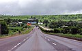
 NH 48 between Hubli and Belgaum | ||||
| Route information | ||||
| Maintained by National Highways Authority of India, Maharashtra State Road Development Corporation | ||||
| Length | 2,807 km (1,744 mi) | |||
| Major junctions | ||||
| North end | Delhi | |||
| South end | Chennai | |||
| Location | ||||
| Country | India | |||
| States | Delhi, Haryana, Rajasthan, Gujarat, Maharashtra, Karnataka, Tamil Nadu | |||
| Highway system | ||||
| ||||
National Highway 48 (NH 48) is a National Highway of India that starts at Delhi and terminates at Chennai and goes through Jaipur, Udaipur, Vadodara, Mumbai, Pune and Bengaluru, traversing through six states of India.[1]
It has a total length of 2807 km (1744 miles).[1]
Its stretch from Delhi to Mumbai was earlier designated NH 8 and the stretch between Mumbai and Chennai was designated NH 4 before all the national highways were officially renumbered in the year 2010.[2]
NH 48 passes through the states of Haryana, Rajasthan, Gujarat, Maharashtra, Karnataka and Tamil Nadu.[1]
Route
NH 48 passes through some of the most important cities in India. They include:
- New Delhi
- Jaipur
- Ajmer
- Udaipur
- Ahmedabad
- Vadodara
- Bharuch
- Ankleshwar
- Navsari
- Vapi
- Thane
- Pune
- Kolhapur
- Belgaum
- Hubballi
- Davangere
- Bangalore
- Vellore
- Chennai
Junction list
- Terminal at Delhi with Rao Tula Marg.
 NH 248A near Gurgaon.
- Cloverleaf interchange with Western Peripheral Expressway near Manesar.
 NH 919 interchange near Dharuhera.
 NH 148B near Kotputli at Behror.
- NH 248A near Sahpura.
 NH 148 near Manoharpur.
 NH 248 near Chandwaji.
 NH 52 near Jaipur bypass.
 NH 21 near Hirapura.
- NH 248 near Hirapura.
 NH 448 interchange near Kishangarh.
- NH 448 interchange near Nasirabad.
 NH 148D near Gulabpura.
 NH 158 near Mandal.
 NH 758 near Bhilwara.
 NH 27 interchange near Chittorgarh.
 NH 162 near Bhatewar.
 NH 58 near Udaipur.
 NH 927A near Kherwada.
 NH 68 near Prantij
Map with spur routes

Gallery
-
-
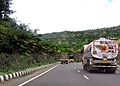
 A stretch of NH 48 between Belgaum and Kolhapur
 -
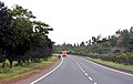
 NH 48 near Pune, Maharashtra


See also
- List of National Highways in India
- List of National Highways in India by state
- National Highways Development Project
References
- ^ a b c Roadnow. "National Highway 48 (NH48) Travel Guide - Roadnow". roadnow.in. Retrieved 17 March 2017.
- ^ "National highway numbers to change, stretches to be longer - Times of India". The Times of India. 18 February 2010. Archived from the original on 19 February 2010. Retrieved 9 October 2017.
{{cite news}}: Unknown parameter|dead-url=ignored (|url-status=suggested) (help)
External links


Secondary routes of National Highway 48 | ||
|---|---|---|
| ||
| Secondary Routes of NH 48 | ||