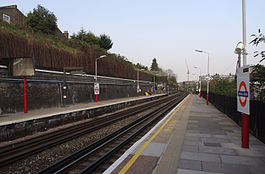
Kensal Green station
| Kensal Green | |
|---|---|
 | |
| Location | Queens Park |
| Local authority | London Borough of Brent |
| Managed by | London Underground |
| Owner | Network Rail |
| Station code(s) | KNL |
| DfT category | E |
| Number of platforms | 2 |
| Fare zone | 2 |
| London Underground annual entry and exit | |
| 2019 | |
| 2020 | |
| 2021 | |
| 2022 | |
| 2023 | |
| National Rail annual entry and exit | |
| 2017–18 | |
| 2018–19 | |
| 2019–20 | |
| 2020–21 | |
| 2021–22 | |
| Key dates | |
| 1 October 1916 | Opened (LNWR & Bakerloo) |
| Other information | |
| External links | |
| Coordinates | 51°31′51″N 0°13′29″W / 51.530746°N 0.22479°W |
Kensal Green is a railway station served by London Underground Bakerloo line and London Overground trains. It is located in College Road, London NW10 close to the junction with Harrow Road. It is about 0.5 mile (750m) route distance from the older Kensal Rise station located to the north east on the North London line, which was itself named Kensal Green until 1890[citation needed]. The station is in a cutting with a tunnel at the western end.[citation needed]
London Overground | |||||||||||||||||||||||||||||||||||||||||||||||||||||||||||||||||||||||||||||||||||||||||||||||||||||||||||||||||||||||||||||||||||||||||||||||||||||||||||||||||||||||||||||||||||||||||||||||||||||||||||||||||||||||||||||||||||||||||||||||||||||||||||||||||||||||||||||||||||||||||||||||||||||||||||||||||||||||||||
|---|---|---|---|---|---|---|---|---|---|---|---|---|---|---|---|---|---|---|---|---|---|---|---|---|---|---|---|---|---|---|---|---|---|---|---|---|---|---|---|---|---|---|---|---|---|---|---|---|---|---|---|---|---|---|---|---|---|---|---|---|---|---|---|---|---|---|---|---|---|---|---|---|---|---|---|---|---|---|---|---|---|---|---|---|---|---|---|---|---|---|---|---|---|---|---|---|---|---|---|---|---|---|---|---|---|---|---|---|---|---|---|---|---|---|---|---|---|---|---|---|---|---|---|---|---|---|---|---|---|---|---|---|---|---|---|---|---|---|---|---|---|---|---|---|---|---|---|---|---|---|---|---|---|---|---|---|---|---|---|---|---|---|---|---|---|---|---|---|---|---|---|---|---|---|---|---|---|---|---|---|---|---|---|---|---|---|---|---|---|---|---|---|---|---|---|---|---|---|---|---|---|---|---|---|---|---|---|---|---|---|---|---|---|---|---|---|---|---|---|---|---|---|---|---|---|---|---|---|---|---|---|---|---|---|---|---|---|---|---|---|---|---|---|---|---|---|---|---|---|---|---|---|---|---|---|---|---|---|---|---|---|---|---|---|---|---|---|---|---|---|---|---|---|---|---|---|---|---|---|---|---|---|---|---|---|---|---|---|---|---|---|---|---|---|---|---|---|---|---|---|---|---|---|---|---|---|---|---|---|---|---|---|---|---|---|
| |||||||||||||||||||||||||||||||||||||||||||||||||||||||||||||||||||||||||||||||||||||||||||||||||||||||||||||||||||||||||||||||||||||||||||||||||||||||||||||||||||||||||||||||||||||||||||||||||||||||||||||||||||||||||||||||||||||||||||||||||||||||||||||||||||||||||||||||||||||||||||||||||||||||||||||||||||||||||||
Legend
| |||||||||||||||||||||||||||||||||||||||||||||||||||||||||||||||||||||||||||||||||||||||||||||||||||||||||||||||||||||||||||||||||||||||||||||||||||||||||||||||||||||||||||||||||||||||||||||||||||||||||||||||||||||||||||||||||||||||||||||||||||||||||||||||||||||||||||||||||||||||||||||||||||||||||||||||||||||||||||
| |||||||||||||||||||||||||||||||||||||||||||||||||||||||||||||||||||||||||||||||||||||||||||||||||||||||||||||||||||||||||||||||||||||||||||||||||||||||||||||||||||||||||||||||||||||||||||||||||||||||||||||||||||||||||||||||||||||||||||||||||||||||||||||||||||||||||||||||||||||||||||||||||||||||||||||||||||||||||||
History
The station opened on 1 October 1916[7] on the new electrified Watford DC Line which runs parallel on the north side of the existing London and North Western Railway (LNWR) tracks from Euston to Watford.

The original station was replaced in 1980.[citation needed]
Bakerloo line services had been running between Queen's Park and Willesden Junction since 10 May 1915.[7]
Since November 2007, National Rail services serving Kensal Green have been operated by London Overground Rail Operations under contract to Transport for London under the London Overground brand; the station is managed by London Underground.[8]
The station was in the news early in 2006, as it was the last station visited by Thomas ap Rhys Pryce before he was murdered in a robbery in Kensal Green. The two main suspects had also visited the station that same night, a short time before the murder, and mugged a man on the platform. A suspect also tried to use Pryce's Oyster Card a day after the incident at the station, and was picked up on CCTV, aiding the police investigation.[citation needed]
This incident sparked a major public discussion on station safety and security, mainly because the station was un-staffed when the passenger was mugged. The only security present was CCTV cameras, and the ticket barriers were left open allowing the suspects to enter the station freely. Many high-profile politicians spoke on the issue of station safety and called on train companies to provide security or staff the station until the last train had left the station.[citation needed]
The Mayor of London at the time, Ken Livingstone, became personally involved in this, and publicly attacked Silverlink, the then operator of the station, for not providing staffing or security throughout the station's opening hours. He also stated that any company that wanted to bid for the subsidy to run the train line would have commit to staffing the station until the last train had left. Eventually, towards the last quarter of 2006, Silverlink hired a private security firm to patrol the station, and also had speakers installed in the ticket hall to deter gangs of youths from loitering.[citation needed]
Connections
London Buses route 18 and night route N18 serve the station.[9]
See also
References
- ^ "Station Usage Data" (XLSX). Usage Statistics for London Stations, 2019. Transport for London. 23 September 2020. Archived from the original on 9 November 2020. Retrieved 9 November 2020.
- ^ "Station Usage Data" (XLSX). Usage Statistics for London Stations, 2020. Transport for London. 16 April 2021. Retrieved 1 January 2022.
- ^ "Station Usage Data" (XLSX). Usage Statistics for London Stations, 2021. Transport for London. 12 July 2022. Retrieved 7 September 2022.
- ^ "Station Usage Data" (XLSX). Usage Statistics for London Stations, 2022. Transport for London. 4 October 2023. Retrieved 10 October 2023.
- ^ "Station Usage Data" (XLSX). Usage Statistics for London Stations, 2023. Transport for London. 8 August 2024. Retrieved 16 September 2024.
- ^ a b c d e "Estimates of station usage". Rail statistics. Office of Rail Regulation. Please note: Some methodology may vary year on year.
- ^ a b "Bakerloo Line, Dates". Clive's Underground Line Guides. Retrieved 22 July 2008.
- ^ "Safety boost as London Underground to take control of 11 Silverlink stations". Transport for London. 5 December 2006. Archived from the original on 13 December 2014. Retrieved 19 February 2015.
- ^ "TfL North West London Bus Map" (PDF).
External links
- Train times and station information for Kensal Green station from National Rail
| Preceding station | Following station | |||
|---|---|---|---|---|
| Willesden Junction towards Watford Junction
|
Watford DC line | Queen's Park towards Euston
| ||
| Preceding station | Following station | |||
| Willesden Junction towards Harrow & Wealdstone
|
Bakerloo line | Queen's Park towards Elephant & Castle
| ||
| Future services | ||||
| Preceding station | Following station | |||
| Old Oak Common towards Harrow & Wealdstone
|
Bakerloo line | Queen's Park towards Elephant & Castle
| ||
- Rail transport stations in London fare zone 2
- DfT Category E stations
- Bakerloo line stations
- Tube stations in the London Borough of Brent
- Railway stations in the London Borough of Brent
- London Underground stations located above ground
- Former London and North Western Railway stations
- Railway stations in Great Britain opened in 1916
- Railway stations served by London Overground
- Kensal Green

