
Aurangabad
Aurangabad
Aurangabad औरंगाबाद | |
|---|---|
city | |
| Government | |
| • Municipal commissioner | Dilip Bund |
| Population (2009) | |
| • Total | 1,210,000 |
| Website | www.aurangabadmahapalika.org/ |
| http://www.citypopulation.de/world/Agglomerations.html | |
Aurangabad ( (औरंगाबाद) from Persian / Urdu: اورنگآباد meaning "Built by the Throne", named after Mughal Emperor Aurangzeb) is a city in Maharashtra, India. The city is a tourist hub, surrounded with many historical monuments including the Ajanta Caves and Ellora Caves which are UNESCO World Heritage Sites, as well as Bibi Ka Maqbara. The administrative headquarters of the Aurangabad Division, or Marathwada region. Aurangabad is said to be a 'City of Gates' as one can not miss the strong presence of these as one drives through the city.
History
The city was founded in 1610 A, D. by Malik Ambar, the Prime Minister of Murtaza. Nizam Shah of Ahmadnagar on the site of a village called Khirki. He made it his capital and the men of his army raised their dwellings around it. Within a decade Khirki grew into a populous and imposing city. However, in 1621 it was ravaged and burnt down by the imperial troops under Shah Jahan. Malik Ambar died in 1626. He was succeeded by his son Fateh Khan who changed the name of Khirki to Fatehnagar. In the same year, the Moghal viceroy Khan Jahan Lodi, advanced on the city but retired to Burhanpur on being bribed by the Nizam Shahi Commander, Hamid Khan. With the capture of Daulatabad by the imperial troops in 1633, the Nizam Shahi dominions including Fatehnagar came under the possession of the Moghals. In 1653 when Prince Aurangzeb was appointed the viceroy of the Deccan for the second time, he made Fatehnagar his capital and called it Aurangabad. Aurangabad is sometimes referred to as Khujista Bunyad by the Chroniclers of Aurangzeb's reign. In March 1666, accompanied by a body of 1,000 select troops, Shivaji arrived at Arrangabad on his way to Agra. Safshikan Khan, the governor of Aurangabad, treated him with scant respect. For this act, he was severely reprimanded by Jai Singh and made to pay a courtesy call on Shivaji. In 1668 the city nearly became a scene of a conflict between the imperial troops under Diler Khan and those commanded by Prince Muazzam, the viceroy. In 1681, after plundering Burhanpur, the Marathas assembled in the neighbourhood of the Sattara hills in order to attack Aurangabad. The plan was, however, abandoned on hearing of the arrival of the viceroy, Khan Jahan Bahadur. In the same year, Khan Jahan Bahadur erected a wall around Aurangabad to protect it against surprise attacks of the Marathas. It was done at the order of the Emperor and cost rupees three lakhs.1 Two years later, the Emperor himself arrived at Aurangabad. In 1692 he ordered a magnificent palace to be erected near the great reservoir to the north of the city the ruins of which are now to be seen in the Killa Ark. A fortified wall was thrown round the suburb of Begampura in 1696 A. D. Shortly after the death of Aurangzeb the city of Aurangabad slipped from the hands of the Moghals. In 1720 Nizamul-Mulk Asaf Jah, a distinguished General of Aurangzeb with the intention of founding his own dynasty in the Deccan, arrived at Aurangabad. He paid a visit to Delhi in 1723, but turned in 1724 2, defying the orders of Emperor Muhammad Shah. Soon after he transferred his capital from Aurangabad to Hyderabad.
The Emperor ordered Mubariz Khan, the Subhedar of the Deccan to oppose the Nizam. A battle was fought near Sakharkherda, subsequently called Fatehkherda, in which Murbariz Khan was defeated and killed. Raghoji, a young scion of the house of the Jadhavs of Sindkhed who fought on the side of the Moghals was also killed. Incensed at the support lent by the Jadhavs to Mubariz Khan, the Nizam despatched a posse of troops to Deulgaon to capture the Jadhav family. But being informed of the design the family escaped to Satara and sought asylum with Chhatrapati Shahu. At the intervention of Shahu the Jagir was restored back to the Jadhavs.
In 1853 A. D. Aurangabad was the scene of a conflict between the contingent troops and a body of Arab mercenaries belonging to Mansing Rav, the Raja of Devalgaon, The Arabs placed the Raja under restraint and threatened his life because their pay was in arrears. Brigadier Mayne, commanding the station, being apprised of the situation, marched out in the first week of October, with the 5th regiment cavalry, 6th regiment infantry and a battery of artillery to Jasvantpura, just outside the Roshangate, where the Arabs had posted themselves. After a stiff resistance, the Arabs were defeated and dispersed and the Raja was released. In the action that was fought the Contingent lost 15 killed and 40 were wounded. Among those killed was Lieut. Boswell, and among those wounded Lieut. Vaughan and Captain Parker. Both of them succumbed to their wounds later.
1857 War of Independence
The year 1857 was eventful in the history of Aurangabad with the rest of the country. The British moved the first cavalry from Mominabad (Ambejogai) to Aurangabad in order to relieve 3rd cavalry which had marched to Malegaon, and was the first regiment to show signs of disaffection. The 2nd Infantry also came under suspicion. It was also feared that the people of the city might join hands with the troops. In order to prevent this all the precautionary measures were taken and two companies of infantry were ordered to guard the bridge which spans the river Kham and separates the cantonment area from the spot where the cavalry was encamped. This precautionary measure on the part of the British alarmed the cavalry and the men turning out without orders threw pickets in the direction of the cantonment. The authorities at Hyderabad were kept informed of the course of events by express. Upon this a column of troops was ordered to march from Pune to Aurangabad. In the meanwhile the artillery was also showing signs of rebellion but the rumour of Bombay troops marching towards Aurangabad had a quieting effect. The men of the cavalry also returned to their posts. The Pune force was under the command of General Woodburn and consisted of three troops of, the 14th Hussars under Captain Gall, Captain Woodcombe's battery of European artillery and the 24th Bombay infantry under Colonel Folliot. Upon his arrival General Woodburn marched straight to the encampment of the 3rd Cavalry, and the disaffected regiment was ordered out to a dismounted parade. The rissaldar of the first troop was directed to call out the names of the revolutionaries, and commenced by giving the name of the senior jamadar, who ordered his men to load their carbines. By this time the General with his staff and the English officers were mixed up with the disaffected troops, and hence the guns could not be used to put down the latter. In the confusion that followed, some of the troopers broke away, ran to their horses and fIed away. The guns were fired upon them and the Hussars were sent in pursuit ; but several of them managed to escape. A dafadar of the cavalry, Mir Fida Ali by name, fired a shot at his commanding officer, Captain Abbott. For this act of his, he was tried by a drum-head, court-martial led and hanged. The court-martial continued its sittings and 24 of these brave men were condemned, of whom 21 were, shot and 3 mercilessly blown away from guns. About two-thirds of the regiment which had remained quiet was marched to Edalabad and recruited to its full strength by men from the other three regiments of the cavalry. Subsequently the third cavalry served throughout the campaign under Sir Hugh Rose.*
Geography
| Aurangabad | ||||||||||||||||||||||||||||||||||||||||||||||||||||||||||||
|---|---|---|---|---|---|---|---|---|---|---|---|---|---|---|---|---|---|---|---|---|---|---|---|---|---|---|---|---|---|---|---|---|---|---|---|---|---|---|---|---|---|---|---|---|---|---|---|---|---|---|---|---|---|---|---|---|---|---|---|---|
| Climate chart (explanation) | ||||||||||||||||||||||||||||||||||||||||||||||||||||||||||||
| ||||||||||||||||||||||||||||||||||||||||||||||||||||||||||||
| ||||||||||||||||||||||||||||||||||||||||||||||||||||||||||||
| Climate data for Aurangabad | |||||||||||||
|---|---|---|---|---|---|---|---|---|---|---|---|---|---|
| Month | Jan | Feb | Mar | Apr | May | Jun | Jul | Aug | Sep | Oct | Nov | Dec | Year |
| Source: weather.msn.com/monthly_averages.aspx?&wealocations=wc%3aINXX0184&setunit=C MSN Weather | |||||||||||||
The location co-ordinates for Aurangabad are N 19° 53' 47" - E 75° 23' 54". The city is surrounded by hills on all sides.
Temperature : Annual temperatures in Aurangabad range from 9 to 40 °C, with the most comfortable time to visit in the winter - October to February. The highest maximum temperature ever recorded was 46 °C (114 °F) on 25 May 1905. The lowest recorded temperature was 2 °C (36 °F) on 2 February, 1911. In the cold season the district is sometimes affected by cold waves in association with the eastward passage of western disturbances across north India, when the minimum temperature may drop down to about 2 °C to 4 °C (35.6 °F to 39.2 °F). [1]
Rainfall : Most of the rainfall occurs in the monsoon season from June to September. Rainfall varies from 9.0 to 693 mm/month. Average annual rainfall is 725 mm.
Population Trends
Economy
There is evidence to believe that Aurangabad was developed as a trading hub four centuries ago. It lies on a major trade route that used to connect north-west India's sea and land ports to the Deccan region.
Manufacturing

The city was a major silk and cotton textile production center. A fine blend of silk with locally grown cotton was developed as Himroo textile. Much of the silk industry has vanished over time, but some manufacturers - such as the Aurangabad Silk Mills, Standard Silk Mills - have managed to keep the tradition alive. Paithani silk saris are also made in Aurangabad. The name of this cloth is derived from Paithan town.
Pharmaceuticals, steel recycling, auto parts manufacturing, and beverage production (soft drinks and beer in particular) are major industries.Among Pharmaceutical there is Recombinant Insulin Manufacturing plant of Wockhardt (Wockhardt Biotech Park)in Aurangabad, Which Largest Biopharmaceutical plant in India.
The Shendra, Chikalthana and Waluj MIDC Industrial Areas are prominent industrial zones on the outskirts of the city, with various major multinational groups having set up manufacturing or processing plants in and around the city.
Banking And Financial Services
In the first decade of the 21st century, Aurangabad has seen a spurt in financial activities, with almost all public sector and private banks have opened up branches including the State Bank of India, State Bank of Hyderabad, Citibank, Deutsche Bank,ICICI Bank, the Bank of India, HDFC Bank, YES Bank, SIDBI , CATHOLIC SYRIAN BANK , KARUR VYASYA BANK , KARNATAKA BANK , STATE BANK OF PATIALA , STATE BANK OF INDORE , J&K BANK , SYNDICATE BANK , INDIAN BANK.
Information Technology
Many IT companies have already been established, with more waiting to establish a presence, probably due to the city's large urban and cosmopolitan population and its proximity to Mumbai, Pune and Hyderabad.
Industrialization
Aurangabad district along with the entire Marathwada region is underdeveloped. The state of underdevelopment in this region can be traced to a multiplicity of factors, which have a long historical background.
|
Criterion |
Aurangabad District |
State Average |
|
1 |
2 |
3 |
|
|
19 |
25 |
|
population. |
14.4 |
28 |
|
sectors. |
22.0 |
38.2 |
|
|
17.88 |
29.82 |
|
total working Population |
5.45 |
11.28 |
Administration and Politics
Aurangabad Municipal Corporation (AMC) is the local civil body. It is divided into six zones.
Aurangabad contributes one seat to the Lok Sabha. The seat is currently held by Mr. Chandrakant Khaire, MP of the Shiv Sena party. It also holds two seats for the Assembly - Aurangabad West (Indian National Congress) and Aurangabad East (National Congress Party).
Media and Communications
Newspapers: Lokmat- is the leading newspaper of the region,Lokmat Times & Lokmat Samachar ,Loksatta, Sakaal, PunyaNagari,sanjvarta
Radio: The city has four FM radio stations - All India Radio, Gyaanvani (dedicated to University learning and distance education) and Radio Mirchi 98.3fm, sfm 93.5,radio city 91.1 fm with the private satellite radio station WorldSpace also available.
Internet: Internet facilities are provided by several suppliers, with BSNLand Hathway[MCN] providing a broadband service
Internet News Aurangabad's First Internet News Portal, covering 1500 Indian cities and 152 Countries, Latest News all over the World [1]
Transport
Intra city Transport
"Aurangabad Municipal Transport" (AMT) is an intra-city bus service which covers almost all parts of the city and also connects to the more distant industrial suburbs. AMT (Aurangabad Municipal Transport) intra-city buses ply throughout the city including the outskirts and connect different parts of the city and adjoining suburbs together. The AMT bus service is affordable, efficient and safe. The AMT buses are quite crowded during morning and evening rush hours.
The "Maharashtra State Road Transport Corporation" (MSRTC) and numerous other private bus operators provide a bus service to all parts of the state.
Metered auto rickshaws ply throughout the city. The fare is based on a meter and is computed by a tariff card available from the driver.
Air
Now Aurangabad has an International airport.Recently there were fights made available to all the people traveling to Haj pilgrimage. Aurangabad Airport has connecting flights to Delhi, Udaipur, Mumbai, Jaipur.
Rail
AURANGABAD(Station Code: AWB) is a station located on the Kachiguda-Manmad section of Hyderabad(HYB) Division of South Central Railway(SCR). The Manmad-Kacheguda Broad gauge railway line which emanates from the Bombay-Bhusawal-Howrah trunk route at Manmad is an important artery of traffic in Aurangabad district. The importance of this line lies in the fact that it has opened for traffic the fertile agricultural tract in Marathwada region. It also serves as a link between Bombay and Secunderabad in Andhra Pradesh. As a matter of fact this line was formerly the only route of traffic as there were no good roads in the Marathwada region. This railway route was opened for traffic in 1900. After Divisional adjustments in 2003, which saw the bifurcation of Hyderabad division, Aurangabad now comes under the newly created Nanded(NED) Division of SCR. Aurangabad has rail connectivity with Manmad, Aurangabad, Nanded, Parbhani, Parli Vaijnath, latur, Osmanabad, Gangakhed, Mudkhed, Adilabad, Nagpur, Basar, Nizamabad, Nasik, Mumbai, Pune, Daund, Mahbubnagar, Kurnool, Kadapa, Renigunta, Tirupati, Katpadi, Erode, Madurai and Kachiguda(HYB). Ajanta Express between Kachiguda and Manmad is the most prestigious train passing through this station.
The "Janashatabdi Express" is the fastest and most comfortable train option to and from Mumbai with a total traveling time of 6 1/2 hours. Three overnight trains and two daytime trains also travel between Mumbai and Aurangabad.
Aurangabad has more number of trains to HYB than to any other city. Ajanta Express, Secunderabad Bi-Weekly Express, Kakinada Express, Devagiri Express, Hyderabad Passenger, Manmad-Kachiguda Passenger, Okha-Rameswaram Express--all these trains connect AWB with HYB
Tourist attractions
- Bibi Ka Maqbara: Situated about 3 km. from the city is Bibi Ka Maqbara, the burial place of Aurangzeb's wife, Rabia-ud-Durrani. It is an imitation of the Taj at Agra and due to its similar design, it is popularly known as the Mini Taj of the Deccan. The Maqbara stands in the middle of a spacious and formally planned Mughal garden with axial ponds, fountains, water channels, broad pathways and pavilions. Behind the mausoleum is located a small archaeological museum.
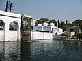
- Panchakki (water mill): Is a 17th century water mill situated at a distance of 1 km from the city. An intriguing water mill, the Panchakki is famous for its underground water channel, which traverses more than 8 km. to its source away in the mountains. The channel culminates in a mesmerising 'artificial' waterfall that powers the mill. The beauty of the mosque housed in the inner enclosure is enhanced by a series of 'dancing' water fountains.
- Gates in aurangabad: One of the things that makes Aurangabad stand out from the several other medieval cities in India are its 52 'gates' each of which have a local history or had individuals linked with them. Not many people are aware of the fact that Aurangabad is also known as the 'City of Gates'.
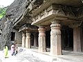
- Aurangabad Caves: Situated at a distance of 5 km, nestled amidst the hills are 12 Buddhist caves probably dating back to 3 A.D. Of particular interest are the Tantric influences evident in the iconography and architectural designs of the caves. One is also treated to a panoramic view of the city as well as the imposing Maqbara from this point.
- Ellora-Ghrishneshwar Temple: Is half a kilometer away from the Ellora Caves, and 30 km. from Aurangabad. The present structure is an 18th century temple that presents outstanding architecture and carving. This place forms one of the five Jyotirlinga sites in Maharashtra where Lord Shiva is worshipped. The Ahilya Devi Holkar temple nearby is a must-see.
- Khuladabad: Is a walled town lying at a distance of 3 km. from Ellora. It is also termed as the Karbala town and forms the holy shrine of Deccan Muslims. It is believed that the Mughal Emperor Aurangazeb was buried here. His simple tomb remains an eloquent testament to the staunch faith and spartan lifestyle of this pious Muslim ruler.
- Pitalkhora Caves: Lies peacefully nestled in the Satmala ranges of the Sahyadris, at a distance of 78 kilometres from Aurangabad. There are 13 cave sanctuaries embedded in this region. These monasteries date back from 2nd century BC to 5th century AD. Rich carvings with elaborate details can be seen in these monuments.
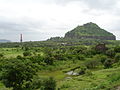
- Daulatabad fort: Earlier known as Devgiri, is situated at a distance of 13 kilometres from Aurangabad. Also termed as the city of foutune, it houses a stupendous 12th century fortress well placed atop a charming hill. This invincible fortress boasts of a 5 kilometer sturdy wall and an intricate series of ramparts.
- Aurangabad Ruins: Naukonda Palace: The most conspicuous ruins are the palace of Asaf Jah and the Killa Arak. Malik Ambar (1546-1626 A. D.), the minister of Murtaza Nizam Shah II established himself at Khirki, the modern Aurangabad and erected a number of buildings and mosques. The Naukonda palace was built by him in 1616 upon the summit of a rising ground. The massive portal gateway leading to this, over which the Naubatkhana sounded, was called Barkal. According to one account a noble of Aurangzeb’s court named Alam, Khan, made additions to this Palace; and further additions were subsequently made by Asaf Jah I. An adjoining block of buildings was screened off by a partition wall for Nasir Jang. The Naukonda palace was also occupied by Nizam Ali Khan, when he was at Aurangabad. The whole place is now in utter ruins. The interior buildings consisted of five zananas, a Divani-Am a Divani Khas, a masjid and a kacheri, each provided with a garden and a cistern. The walls of the central part of the Devankhana, and a hamam or hot bath attached to the building, are in a fair state of preservation. However, the wood-work and the stucco plaster are all gone. The Divani-Am is a large quadrangular structure much in ruins. The Kacheri close by contains a gadi of the Nizam. In the throne room are placed the original paraphernalia.
- Killa Arrak: In 1692, Aurangzeb ordered a palace to be built and named it as the Killa Arrak. The space enclosed by the Killa Arrak or citadel covered nearly the whole ground between the Mecca and Delhi gates of the city. It had four or five gateways and a nagarkhana for the musicians. The walls were battle-mented and loop-holed and had semi-circular towers at the angles, on which guns were once mounted. The inner portion was occupied by recesses similar to those in the city walls. To the right of the entrance was a high terrace extending the whole length of the ground enclosed. On this the remains of an extensive garden and half ruined tanks and cistern can still be traced. The Am Khas or the Darbar Hall, and the Jumma masjid are the only remains of interest. A plot of ground close to the masjid was walled in for purposes of sport. The gate leading to this ground contains an inscription dated in, 1659 A. D. The takht or throneroom of Aurangzeb is in a garden pavilion and has a rostral appearance. It is of a plain and simple description.
- Barra Darri: Salar Jang’s palace and Govind Baksh’s mahal were between the Paithan and the Jafar gate. The Damri Mahal and the Barr Darri of Ivaz Khan are close to the Delhi gate. The Mahal is new occupied by the Collector’s Office. The Barra Darri and the adjoining buildings were erected by Ivaz, Khan. A covered aqueduct passes over one of the buildings and in the olden days water descended in a shower into an oblong cistern below containing several fountains. It is now inoperative.
- Demri Mahal: The Damri Mahal which is close by was built after the completion of the Barra Darri. It is so named because it was constructed by levying a contribution of a ‘damri’ or the quarter of a dub, on an labourers employed on Barr Darri. An arcaded verandah projects in front like a portico, and contains five scolloped arches. Behind are ten rooms of varying sizes, arranged in a line. To the right are seven atom chambers with antechambers. The entrance is in the right corner. Close by, on a slightly higher level than the rest is another small but detached building. The roof is arched. There are also two cisterns, one in front of the verandah and another outside the building.
- Kali Masjid, Jumma Masjid: Among the mosques, the Jumma masjid and the Kali masjid built by Malik Ambar, and the Shah Ganj mosque are the most conspicuous. Malik Ambar is said to have built seven mosques which go by the general name of Kali masjid. The Kali masjid is in Juna Bazar area and was erected in 1600 A. D. It is a six-pillared stone-building standing on a high plinth. The Jumma masjid of Malik Ambar is near the Killa Arrak. It has fifty polygonal pillars arranged in five rows, and connected by a system of arches, which divide the building into twenty-seven equal compartments, each covered by a domical vault of simple but elegant design. There are nine pointed arches in front. Of these, five were erected by Malik Ambar in 1612 A. D. and the remaining four were added by Aurangzeb. The plinth is high and contains several chambers which open on the market side. The sloping cornice is supported on brackets, and the parapet wall is neatly perforated. The corner angles contain octagonal shafts, ornamented with discs and carrying little domes. The design of the mosque is in very good taste, plain but solid, and more like the buildings of Bijapur. A spacious court in front of the mosque has open-fronted buildings in three sides for travellers. In the centre of the court there is a cistern drawing its supply from the Malik Amber canal popularly known as Nahar Amberi.
- Shah Ganj Masjid : Occupying the great market square of Aurangabad is the large Shah Ganj mosque, one of the finest edifices of its class to be found in any put of India. It was built in about 1720 A.D. Khafi Khan, the author of Muntakhabu-1-Lubab, referring to Sayyad Husain Khan’s viceroyalty of the Deccan (1714-1719) says "the reservoir at Shah Ganj was begun by Sayyad Husain Ali, and although Aazu-d Daula Iraz Khan enlarged and made higher the buildings and mosques still Sayyad Husain Ali was the originator of that extensive reservoir, which in summer, when water is scarce relieves the sufferings of the inhabitants". The mosque is on a raised platform, and has shops on three of the outer sides; while the fourth or the north side is open and is ascended by a flight of steps the facade represents an arcade of five scolloped arches, constructed in the Indo-Saracenic style, and supported on stone pillars. This portion projects a little; and the interior contains twenty four pillars, which with six pilasters in the back wall, are arranged in the form of a square. The central portion is covered with a graceful bulbous dome, having the base adorned with crisp crinkled lotus leave tied in a neat narrow band; and the apex bears an elegant spire. Arcaded monasteries called Kham Khas, form the east and the west wings, and consist of five arches on either side, constructed like the arches of the main building, but of horizontal structure. The interior is connected by horizontal arches ; and the roof is formed of a series of little domes, each supported on four pillars. There are minarets at the corners of the main building, and at the end angels of the Kham Khas. The courtyard in front contains two large cisterns. The entrance is in the form of a little mosque, with a pointed arch and two minarets.
- Chauk Masjid: In 1655 was built the Chauk Masjid by Shayista Khan, the maternal uncle of Aurangzeb. Its front has five pointed arches, and is two arches in depth. These are connected with one another by eight pillars and corresponding pilasters, and support five domes. The central dome, with a metallic spire is lofty, while the others are concealed in the roof. The corners are decorated with minarets. The whole structure has a high basement containing chambers used for shop, which open out on the roadside. The gate has two minarets. There is a cistern in the courtyard in front of the mosque
- Paithan: Is an ancient taluka town, which lies 50 km. to the south of Aurangabad. The looms of Paithan still weave the beautiful Paithani saris that are prized by women. It has formed a very important excavation site recently. Of the few attractions found nearby, the Jayakwadi dam is a treat to the eyes of the avid bird watchers. The garden is on the lines of Vrindavan Garden of Mysore with channels of flowing water, musical fountain, varied trees, plants, shrubs, and flowers. It is one of the best maintained gardens. The lighting arrangement is also very charming. The entire garden creates the most picturesque and enchanting environment. The town is also famous for the Dnyaneshwar Udyan, which is the largest garden in Maharashtra, and a museum which treasues a fascinating collection of art.
- Ellora: The cave temples of Ellora, listed among the World Heritage sites, are 30 km northwest of the city. Ellora caves are again rock-cut caves with beautiful temples and monasteries. There are 34 caves in all, which have been segregated as 12 Mahayana Buddhist caves (550-750 A.D.), 17 Hindu caves (600-875 A.D) and 5 caves of the Jain faith (800-1000 A.D.). Lately 22 new caves have been discovered that are dedicated to Lord Shiva. Carved out of a single huge rock, there is a gateway, pavilion, courtyard, vestibule, sanctum and tower. The Kailash Temple near the caves is a major attraction of this place.
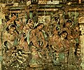
- Ajanta: The world famous Buddhist caves at Ajanta, also a World Heritage site, lies to the northeast of Aurangabad. The splendid caves of Ajanta are not new to anyone. Nestling in the tranquil laps of the Sahyadri hills, at a distance of 100 km. from Aurangabad are 30 rock cut caves of Ajanta that date back to 2nd century B.C. The caves have on display, exquisite paintings, and sculptures depicting Buddha's life, halls and monasteries. The land was discovered in 1819, by a group of British officers.
- Pariyon ka Talab: Situated at a distance of 30 km, Pariyaon ka Talab translated to mean 'Fairies' Lake', is a large lake with steps all along its western shore and a stage like platform which bears great resemblance to the ancient Roman Amphitheatre. On the banks is also a temple of Shiva with its own colourful history.
- Bani Begum Gardens: 24 kilometers from Aurangabad lie the Bani Begum Gardens, which surrounded the tomb of one of Aurangazeb's queens. Bani Begum was the wife of one of Aurangazeb's sons. One can come across fluted pillars, massive domes and fountains that are built is various different styles.
- Mhaismal: 25 km from Aurangabad, is another tourist spot. Mhaismal original called 'Maheshmal'. An ancient temple of Girijamata is in the village and an exact replica of Lord Balaji temple at Tirupat is located at the top of hill. It is a small but beautiful hill station situated on the way to Ellora caves.
- Lonar Crater: 122 km away from the city is Lonar - one of the world's 5 largest craters, formed by the impact of meteorite nearly 50,000 years ago. It is also believed that impact craters like the Lonar crater is one of the probable causes for the extinction of dinosaurs. The surface diameter of the crater is nearly 1.75 km., and its depth is nearly 132 metres. At its base has formed a beautiful lake, formed over thousands of years by the perennial streams flowing into the crater. On the periphery of the lake are temples built in the 12th - 13th century. Their exquisite carvings are remnants of their glorious past.
- Gautala Sanctuary: Is a sanctuary situated at a distance of 65 km from Aurangabad. Spread in the hill ranges of Sahyadri in the proximity of Aurangabad and Chalisgaon. The diversified vegetation scattered intermittently support rich faunal and floral diversity. Particularly it is good for sloth bear habitat and excellent for resident and migratory birds.
- Museums: Aurangabad is home to some of the best museums that are unknown and forgotten. It hosts the State Archaeology Museum (Sonehri Mahal), University History Museum and Aurangabad Municipal Corporation Museum. These museums house some of the historical landmarks of this city's growth. Objects from the excavations of the ASI - Archaeological Survey of India are here. Coins, medals, seals, tools, arms, armour, jewellery, manuscripts, textiles, gems can be seen here but are little known and unique.
- Folk Art: Aurangabad hosts the greatest folk art traditions and can boast of Tamashas and Lavanis, Powadas and Gondhals, Rang Baazi and Sawaal Jawab, Dhol Nritya, Jhimma, Phugdi, Tarpi, Dindi and Folks Songs.
- Other attractions: An Ideal Gateway to Religious Destinations namely Shirdi, Nanded, Paithan, Grishneshwar, Shani Shingnapur, Aundha Nagnath, Parli Vaijnath, Khadkeshwar, Bhadra Maruti Deosthan all of which are well connected by road and railways to the city.
Local Arts
- Paithani Textiles: From this region have found recognition for their unique charm. The Paithani sarees from paithan, which is 50 km from Aurangabad even today, are considered to be priced possession by one and all. One can get an opportunity to witness this 2000-year-old art of weaving Paithani sarees. The yarn used is of pure silk and the zari or gold threads are drawn from pure gold.
Mashru and Himroo
Aurangabad is famous for Mashru and Himru fabrics made of cotton and silk with the luster of satin. Himru is an age-old weaving craft, and was originally known as kum khuab.
- Himroo : Mohmmad Tughlak introduced Himroo weaving in Aurangabad when he shifted his capital from Delhi to Daulatabad. Members of the royal family and an elite few used the famous Aurangabad Himroo. Himroo weaving is very characteristic and distinctive. Fabrics and shawls from Aurangabad are much in demand for their unique style and design.
- Bidriware: A unique form of gold/silver inlays on copper is preserved here from ancient Persian traditions that have been sustained in the Deccan. This ancient art still finds expression in the modern items like cufflinks, nameplates and more. Typical bidri items include plates, bowls, vases, ashtrays, trinket boxes, huqqa bases and jewellery.
- Kaghzipura: A place situated near Daulatabad made first handmade paper in India after the technology was brought here by Mongol invaders - it is a landmark even today. Interestingly this paper has been used to print the holy Quran.
Gallery
-
-
 Kailasha Temple in Ellora Caves
 -

-
 Kailash temple in Ellora Caves
 -
-
 Daulatabad (deogiri) fort
 -
 Panchakki, The Fountain.
 -
 Siddhartha Garden
 -
 Painting from the Ajanta Caves in Aurangabad, Maharashtra, sixth century.
 -
Soneri Mahal
-
Sant Dnyaneshwar Udyan, Paithan
-
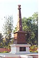 Hutatma Stumbh
 -


.jpg)

.JPG)
.JPG)


.JPG)
Parks
- Bibi Ka Maqbara
- Mhaismal hills
- Lonar - a natural lake formed by meteorite impact (Near Mehekar) - 150 km from Aurangabad
- Sant Dnyaneshwar garden, Paithan - 50 km from Auranagabad
- Jayakwadi dam bird sanctuary: home for migratory birds from Siberia - 45 km from Aurangabad
- Gautala wildlife park and bird sanctury
- Siddarth Garden
- A state-of-art park to be developed @ SALIM ALI LAKE over 25 acres (100,000 m2) and a similar to be developed after undertaking HIMAYATBAG area . BOTH TO BE DEVELOPED BY AMC(Aurangabad Municipal Corporation)
Major Areas of Aurangabad City
|
|
|
==Attractions in Aurangabad==
|
Geographical Location
Places adjacent to Aurangabad | ||||||||||||||||
|---|---|---|---|---|---|---|---|---|---|---|---|---|---|---|---|---|
| ||||||||||||||||
References
akheel
External links
- Aurangabad Latest news
- Aurangabad city info
- Template:Wikitravel
- Aurangabad Art Architecture Archcelogy History Culture Study Project
- Government's tourism page
- Aurangabad Municipal Corporation
| Topics | |||||||||||||
|---|---|---|---|---|---|---|---|---|---|---|---|---|---|
| Regions | |||||||||||||
| Divisions and Districts |
| ||||||||||||
| Million-plus cities in Maharashtra | |||||||||||||
| Other cities with municipal corporations | |||||||||||||
| Government | |||||||||||||