
Makati
City of Makati
Lungsod ng Makati | |
|---|---|
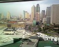
 Skyline of Makati City | |
| Nickname(s): The Financial Capital of the Philippines; The Wall Street of the Philippines; "Metro Manila's Central Business District" | |
| Motto(s): Makati, Mahalin Natin, Atin Ito (Makati, Love It, This Is Ours) | |
 Map of Metro Manila showing the location of Makati City | |
| Country | Philippines |
| Region | National Capital Region |
| Province | none (It is formerly on Rizal province until 1975) |
| Districts | 1st and 2nd districts of Makati City |
| Barangays | 33 |
| Incorporated (town) | 1670 |
| Incorporated (city) | January 2, 1995 |
| Government | |
| • Mayor | Jejomar Binay (2007-2010; PDP-Laban/GO) |
| • Vice Mayor | Ernesto S. Mercado (2007-2010; PDP-Laban/GO) |
| Area | |
| • Total | 27.36 km2 (10.56 sq mi) |
| Elevation | 15.4 m (50.5 ft) |
| Population (2007) | |
| • Total | 510,383 |
| • Density | 18,654/km2 (48,331/sq mi) |
| Time zone | UTC+8 (PST) |
| ZIP code | 1200 to 1299 |
| Area code | 2 |
| Website | www.makati.gov.ph/ |
The City of Makati, or simply Makati, is one of the cities and municipalities that make up Metro Manila, the greater metropolitan area of the national capital of the Philippines. It is the major financial, commercial and economic hub in the Philippines, often referred to as the financial capital of the Philippines since many global companies have their offices and headquarters in the city. Makati is also home to the influential Makati Business Club and the Philippine Stock Exchange. Ayala Avenue, running through the heart of the Central Business District is often called the Wall Street of the Philippines.[citation needed]
The City
Makati is noted for its highly cosmopolitan culture, also being a major cultural and entertainment hub in Metro Manila. Many expatriates live and work in the city. Makati is also home to many first-class shopping malls, which are located at Ayala Center and Rockwell Center. Makati also has the tallest buildings in the Philippines like PBCOM Tower, G.T. International Tower.
The city also has many of the country's five-star hotels like The Peninsula Manila, the Shangri-La Hotel Makati and the Intercontinental Hotel Manila. Independent business travelers also benefit from budget hotels like the Saint Illian's Inn, El Cielito Inn, The Copa Businessman's Hotel, and The City Garden Suites, while serviced apartments like The Salcedo Suites, Fraser Place Manila, The Sunette Tower, and The Oxford Suites are gaining in popularity among business-minded travelers as well.
Makati came from the Tagalog word kati, which means tide.[citation needed] This primarily refers to the rise and ebb of the tide of the Pasig River on the city's northern border. The city was also known as San Pedro de Macati during the Spanish era.
Today the city is one of the most modern cities in the country and the Philippines' major global economic competitor in Asia.[citation needed] However, it faces challenges due to the disparate gap between the new city in the west, which contains the Central Business District, and the old city in the east, which is largely poor and where most of the city's slums are located.
History
| Date | Milestone |
|---|---|
| 1578 | It was Miguel López de Legazpi, the founder of Manila and first Governor-General of the Philippines, who first spotted the area, which he dismissed then as a worthless swamp. Legaspi asked the name of the place but, because of the language barrier, was misinterpreted by the natives. Pointing to the receding tide of Pasig River, the natives answered, “Makati, kumakati na” meaning “ebbing tide.” |
| 1578 to 1670 | Makati was a “visita” or district of Santa Ana de Sapa under the jurisdiction of a Franciscan priest named Pedro de Alfaro. Makati was then known as San Pedro de Makati in honor of its patron saint. In this community, the friars established two of the earliest churches in the Philippines — the Nuestra Señora de Gracia in Guadalupe and the Church of Sts. Peter and Paul — in Makati, which attracted the faithful from all over the country. |
| 1900 | At the turn of the century, the Americans established Fort McKinley in Makati. |
| 1901 | San Pedro de Macati, with a population of 2,500, was incorporated into the province of Rizal. |
| February 28, 1914 | The Philippine Legislature passed Act 2390, shortening the name San Pedro de Macati to Makati in the 1930s, the first airport of Luzon, Nielson Field, opened in what is now the Ayala Triangle. |
| 1950s to 1970s | The first centrally planned community was established in the 1950s, and since the 1970s, Makati has been the undisputed financial and commercial capital, the once worthless swampland becoming prime real property.[citation needed] |
| 1975 | Makati was separated from Rizal province along with Caloocan, Malabon, Navotas, Quezon City, Marikina, San Juan, Pasig, Mandaluyong, Pateros, Taguig, Pasay City, Parañaque, Las Pinas, and Muntinlupa. |
| 1980s | Makati has also figured prominently in the political history of the Filipino. The community was one of the cradles of the revolt against Spanish colonial rule, and following the assassination of Ninoy Aquino in 1983, the epicenter of the protest movement against the rule of President Ferdinand E. Marcos. |
| 1986 | Jejomar C. Binay was inaugurated as an acting mayor by Corazon C. Aquino after the People Power in EDSA and he was elected as the real mayor in 1987. |
| January 2, 1995 | Makati became an independent city by virtue of Republic Act 7854. |
| June 30, 1998 | The Lone District of Makati City was separated and divided into 2 districts. Lone District Representative Joker Arroyo became the representative of the first district, while Senator Agapito Aquino was elected representative of second district. |
| June 30, 2001 | Mayor Jejomar C. Binay came back to his position after his wife became a mayor. |
| 2006 | Mayor Jejomar Binay was suspended by the ombudsman for corruption charges like his friend, Pasay City Mayor Peewee Trinidad, but Binay remained suspended for only 3 days. Mayor Jejomar Binay and his Wife former Mayor Elenita Binay face dozens of administrative and criminal suits because of Graft and Corruption. Despite these allegations the people of Makati City remained to be loyal to the kingpin of the city who is one of the corrupt mayors in the Philippines. |
Geography and Landmarks

Makati is located within the quadrangle of 14′40″ °north and 121′3″ °E right at the center of Metro Manila. The city is bounded on the north by the Pasig River, facing Mandaluyong City, on the northeast by Pasig City, on the southeast by the municipality of Pateros and Taguig City, on the northwest by the City of Manila, and on the southwest by Pasay City. Makati has a total land area of 27.36 square kilometers; it constitutes 4.3 % of Metro Manila's total land area.
At the center of the city is the Central Business District (CBD) where many companies in the Philippines have their offices or headquarters. This is where many of the country's tallest skyscrapers are located. The Makati skyline is one of the most impressive sights in Metro Manila.
Two of Metro Manila's main arteries pass through Makati. The Epifanio De los Santos Avenue (EDSA) pass along the southeast part of Makati and connects the city with Mandaluyong City and Pasay City The South Luzon Expressway (SLEX) runs through the western part of Makati and connects the city with Manila to the north and with southern Metro Manila. The Skyway, an elevated highway built on top of SLEX, provides residents coming from southern Metro Manila a fast way to reach Makati. SLEX and EDSA intersect at the Magallanes Interchange, which is the most complex system of elevated roadways in Metro Manila.
Other major roads in Makati include Buendia Avenue, also called Sen. Gil Puyat Avenue, which connects EDSA and SLEX in the north; Ayala Avenue, an important street that runs through the Central Business District; and Makati Avenue, which connects Ayala Avenue with Buendia Avenue, also extending north to cross the Pasig River to Mandaluyong City. At the center of Makati is the Ayala Triangle, a park built on the former Nielsen Air Base.
Makati's sister city is Los Angeles, California. Makati is also twinned with Ramapo, New York.[citation needed]
Boundary dispute
Makati City and Taguig have recently fought over the jurisdiction of Fort Bonifacio. This Philippine military base, most of which has been converted to a modern commercial and residential development area, lies in an ambiguous area. A portion of the base, including the Libingan ng mga Bayani (Cemetery for the Heroes) and the Manila American Cemetery and Memorial lies within Taguig, while the northern portion where the development center is now located used to be considered part of Makati. A 2003 ruling by a judge in the Pasig Regional Trial Court has upheld the jurisdiction of Taguig over the whole of Fort Bonifacio, including the Fort Bonfacio Global City.
Ruling
The Supreme Court on June 27, 2008 per Leonardo Quisumbing, dismissed the suit of the Makati City, seeking to nullify Special Patents 3595 and 3596 signed by Fidel Ramos conveying to the Bases Conversion and Development Authority public land in Fort Bonifacio, Taguig City. Because of a pending civil case filed by the Taguig City government asking the court to define its territorial boundaries, Makati therefore cannot yet stop Taguig from collecting taxes on land located in Fort Bonifacio.[1][2][3] Taguig City is a big threat to Makati City where round-the-clock construction of office and residential towers, as well as hotels and retail and commercial areas.
Population
Makati City has a population of 444,867, according to the 2000 Census. This figure represents an increase of 39,824 or 8% over the 1995 Census figure. Among the cities and municipalities in Metro Manila, Makati ranks fifth in population, with a 5% share. In a span of 97 years, Makati's population grew 193 times. The 1903 Census placed the population at 2,700.
Although its population is slightly less than half a million, the daytime population of Makati City is estimated to be a million during a typical working weekday because of the large number of people who go to the city to work, shop, and do business, especially in the Central Business District.[citation needed]
The Central Business District
The Central Business District (CBD) is where most of Makati's financial resources are concentrated. This is an informal district bounded by Gil Puyat Avenue (formerly Buendia), Makati Avenue, Ayala Avenue, Arnaiz Road (formerly Pasay Road), and Chino Roces (formerly Pasong Tamo). It mainly encompasses Legaspi Village, Salcedo Village, and parts of Bel-Air. Much of the area is owned by Ayala Land, Inc and administered through Makati Development Corporation, its subsidiary.
Many skyscrapers rise in this area. PBCom Tower along Ayala Avenue is the country's tallest building and reaches up 259 meters.[4][5] It is the headquarters of the Philippine Bank of Communications, or PBCom. The Business District is also considered as one of the most vibrant commercial districts in South-East Asia. Makati CBD is considered to be a major metropolis affecting world economies.
One of the trading floors of the Philippine Stock Exchange is housed in Ayala Tower One and at the old Makati Stock Exchange Building, both also along Ayala Avenue. The Bank of the Philippine Islands (BPI), the country's oldest bank, has its headquarters at the corner of Ayala Avenue and Paseo de Roxas.
Other companies that have their offices and country/regional headquarters within Makati City, most within the CBD, include Philippine Savings Bank (PSBank), IBM, Procter & Gamble, Citibank, Ayala Corporation, Development Bank of the Philippines (DBP), Metrobank, Intel Philippines, Microsoft Philippines, Nestlé, Syngenta, Shell, Convergys Corporation, PeopleSupport, Pan Pacific Computer Center, Inc. (PPCC), Colgate-Palmolive Philippines, Inc., Holcim Philippines, and JG Summit, Accenture. Hewlett Packard's main Philippines office and an HP service center are in Makati City.[6]
The Embassy of Switzerland, which serves the Philippines, Federated States of Micronesia, and Palau, is located in Makati City.[7]
Shopping centers
Ayala Center, along EDSA and Ayala Avenue is the most known commercial center in the city. Developed by the Ayala Corporation, it contains two shopping malls, Glorietta and Greenbelt, five hotels, and an office building. The larger of the two shopping malls is Glorietta, which itself is a cluster of malls. Rising from Glorietta 4 is the Ascott Tower(formerly Oakwood Premier), a luxurious hotel-apartment residence at the heart of the center. Along the periphery of Glorietta are three department stores: SM Department Store Makati, Rustan's, and the Landmark. Across Makati Avenue from Glorietta is Greenbelt. This is one of the most sophisticated, modern, and expensive malls in the country. Greenbelt features dozens of coffee stores and restaurants, all overlooking a well-landscaped green park at the center where a domed Catholic chapel dominates the skyline. Other hotels in the vicinity of Ayala Center are the Makati Shangri-la Hotel, the Manila Peninsula, the Dusit Hotel Nikkō, Manila Garden, the Hotel Intercontinental Manila, and Renaissance Makati City Hotel. Soon to rise is the Raffles Residences Manila, now under construction at the corner of Makati Avenue and Arnaiz Avenue (formerly Pasay Road).
Rockwell Center is the other first-class shopping center in Makati. Rockwell features the large Power Plant Mall popular with expatriates. At the periphery of the center are many high-class residential condominium towers, the Asian Eye Institute, and the Ateneo de Manila Professional Schools main campus, which houses the Ateneo Law School, the Ateneo Graduate School of Business, and the Ateneo School of Government.
Housing and residences
Many of the country's wealthiest families live in North and South Forbes Park, originally developed in 1948, and Dasmariñas Village, originally developed in the 1960s, on the other side of EDSA from the Central Business District. Other well-to-do people live in San Lorenzo Village, Urdaneta Village, Bel-Air Village, Palm Village, Magallanes Village, and San Miguel Village. Others live in condominiums and apartment units in the Central Business District of Salcedo Village, Legazpi Village and San Antonio Village. These "villages" are not rural settlements, but gated communities. The usage probably arose because most villages correspond to barangays. In these communities, homeowner associations may assess punitive fees and impose regulations through management companies such as Ayala Land. Most of the average residents of the city live in the city's periphery, especially in the eastern portions of Rizal, East and West Rembo, Pembo, Comembo, South Cembo, and Pitogo.
Housing, especially for the poor residents of the city, remains an acute problem. Some in the outlying provinces migrate to Metro Manila looking for better living but end up squatting in many areas of the metropolis. In Makati, the squatter shanties lie mostly around Guadalupe on the bank of the Pasig River, except on the barangays in the privately-owned Central Business District.
Education, culture, and sports
Educational Institutions in Makati City
- AMA Computer College
- Asia Pacific College
- Asian Institute of Management (AIM)
- Asian Seminary of Christian Ministries (ASCM)
- Assumption College
- Ateneo Professional Schools
- Benigno S. "Ninoy" Aquino Jr. Science High School [1]
- Bethany Baptist Academy Makati
- Centro Escolar University Makati
- Colegio San Agustin
- Colegio de Sta. Rosa
- De La Salle-Professional Schools, Inc.
- Don Bosco Technical Institute
- Fort Bonifacio High School
- Gen. Pio Del Pilar National High School
- International School Manila [2]
- Lyceum of the Philippines College of Law
- Rolf Jost Information Technologie Institute
- Makati High School
- Makati Hope Christian School
- Makati Science High School
- Mapúa Institute of Technology
- Our Lady of Guadalupe Minor Seminary
- Philippine School of Interior Design
- RTRMS-Makati Medical Center
- St. Augustine School of Nursing
- San Carlos Seminary
- Saint Paul College of Makati
- San Antonio National High School
- San Isidro National High School
- STI Makati
- University of Makati [3]
- Informatics Computer Institute of Makati
Makati City is home to the Asian Institute of Management (AIM). AIM, located along Paseo de Roxas across Greenbelt began as a collaborative project of the Ateneo de Manila University and De La Salle University. The Ateneo Professional Schools, a unit of the Ateneo de Manila University has facilities in Rockwell Center and Salcedo Village. The Rockwell campus houses the Ateneo Law School, the Ateneo Graduate School of Business, and the Ateneo School of Government. The Salcedo campus houses the Ateneo Information Technology Institute. De La Salle University's Professional Schools also operates in RCBC Tower along Ayala Avenue. Mapua Institute of Technology alongside Buendia which is an extension of Mapua in Intramuros in Manila.
Other notable colleges and Universities in Makati are the Asian Seminary of Christian Ministries (ASCM) [4],Don Bosco Technical Institute Makati, Assumption College, Colegio San Agustin, Asia Pacific College, the University of Makati. Assumption College, in San Lorenzo Village, is an all-female college. The University of Makati (officially, Pamantasan ng Makati) is a university run by the city government. Also in the city are the Makati Science High School and Benigno "Ninoy" Aquino High School, both city-run high schools. Remedios Trinidad Romualdez Memorial Schools, named after Doña Remedios Romualdez, the mother of the former first-lady Imelda Romualdez-Marcos a private nursing school owned by of one of Makati's renowned hospitals, Makati Medical Center.
The Sta. Ana Racetrack, which actually part of the City of Manila, beside Pasig River in the northern part of the city, is one of the two centers of horseracing in the country. The other is in the San Lazaro Leisure Park in Carmona, Cavite. Along the south-eastern border of Makati beyond Forbes Park are the Manila Golf Club and the Manila Polo Club [5]. The Manila Golf Club features an 18-hole golf course amidst the lush greenery of the city. The Manila Polo Club counts among its polo enthusiasts some of the country's wealthiest people. The Makati Sports Club in Salcedo Village is another popular place for sports people. The Makati Coliseum is another famous sports landmark in the city, where some of the biggest sports gatherings are held.
The Ayala Center also features aside from its shopping malls the Ayala Museum. This museum is most noted for its series of dioramas depicting major events in Philippine history, from the Battle of Mactan, to the People Power Revolution.
Makati has many Spanish-era churches, such as the Our Lady of Guadalupe and the Nuestra Señora de Gracia (Our Lady of Grace) in the old town. At the Greenbelt Park stands the modern-style domed chapel of the Sto. Niño de la Paz. Between Forbes Park and Dasmariñas Village is the Santuario de San Antonio, a popular church for weddings in the Makati area. The National Shrine of the Sacred Heart is located in San Antonio Village.
At the northern part of the city is the 25-hectare Manila South Cemetery. Every All Saints Day, thousands of people flock to the cemetery to pay their respects to their deceased loved ones.
Transportation
Buses plying the Epifanio De los Santos Avenue (EDSA) route from Baclaran in Paranaque to Quezon City and Caloocan City pass through the Central Business District daily. Jeepneys ply Makati's inner roads, and connect the city to its surrounding towns and cities. The Metro Rail Transit (MRT-3) on EDSA has four stations located in Makati: Guadalupe, Buendia, Ayala and Magallanes.
Government
Like other cities in the Philippines, Makati City is governed by a Mayor and Vice Mayor who are elected to three-year terms. The Mayor is the executive head and leads the city's departments in executing the city ordinances and improving public services. The Vice Mayor heads a legislative council consisting of 18 members: 8 Councilors from the First District, 8 Councilors from the Second District, the President of the Sangguniang Kabataan (Youth Council) Federation, representing the youth sector, and the President of the Association of Barangay Chairmen (ABC) as barangay sectoral representative. The council is in charge of creating the city's policies in the form of Ordinances and Resolutions.
Seal of Makati City
The official seal of Makati City depicts a silhouette of the territory of Makati. At the bottom is the Pasig River, located on the northern border of the city. The Guadalupe Church stands on the river and is the oldest church in Makati—a reference to Spanish influence. Behind the church rises the skyscrapers for which Makati City is well-known. Behind the skyscrapers are 33 rays representing the barangays of Makati. Makati city is divided into 33 barangays. These barangays are grouped into two congressional districts, with each district represented by a congressman in the House of Representatives. Congressional District I occupies the western and modern half of the city, while District II covers the poorer half.

Current Officials (2007–2010)
Barangays
| Barangay | Population (year 2004) |
Area (km²) |
District |
|---|---|---|---|
| Bangkal | 22,433 | 0.74 | (1st) |
| Bel-Air | 9,330 | 1.71 | (1st) |
| Carmona | 3,699 | 0.34 | (1st) |
| Cembo | 25,815 | 0.22 | (2nd) |
| Comembo | 14,174 | 0.27 | (2nd) |
| Dasmariñas | 5,757 | 1.90 | (1st) |
| East Rembo | 23,902 | 0.44 | (2nd) |
| Forbes Park | 3,420 | 2.53 | (1st) |
| Guadalupe Nuevo | 22,493 | 0.57 | (2nd) |
| Guadalupe Viejo | 13,632 | 0.62 | (2nd) |
| Kasilawan | 6,224 | 0.09 | (1st) |
| La Paz | 8,843 | 0.32 | (1st) |
| Magallanes | 7,509 | 1.20 | (1st) |
| Olympia | 20,172 | 0.44 | (1st) |
| Palanan | 16,614 | 0.65 | (1st) |
| Pembo | 35,035 | 1.23 | (2nd) |
| Pinagkaisahan | 6,186 | 0.16 | (2nd) |
| Pio del Pilar | 22,495 | 1.20 | (1st) |
| Pitogo | 13,367 | 0.14 | (2nd) |
| Poblacion | 8,446 | 0.46 | (1st) |
| Post Proper Northside | 1,475 | 0.45 | (2nd) |
| Post Proper Southside | 25,037 | 0.60 | (2nd) |
| Rizal | 37,022 | (2nd) | |
| San Antonio | 12,226 | 0.89 | (1st) |
| San Isidro | 8,686 | 0.50 | (1st) |
| San Lorenzo | 6,487 | 2.09 | (1st) |
| Santa Cruz | 7,419 | 0.47 | (1st) |
| Singkamas | 6,226 | 0.13 | (1st) |
| South Cembo | 13,570 | 0.20 | (2nd) |
| Tejeros | 16,820 | 0.29 | (1st) |
| Upgrade SHS Katipunan | 4,702 | 0.28 | (1st) |
| Upgrade SHS Novaliches & Commonwealth | 4,679 | 0.30 | (1st) |
| Urdaneta | 3,817 | 0.74 | (1st) |
| Valenzuela | 5,908 | 0.24 | (1st) |
| West Rembo | 28,889 | 0.55 | (2nd) |
Former Mayors
- Marcelino Magsaysay, (1901–1903)
- Eusebio Arpilleda, (1903–1908)
- Hermogenes V. Santos, (1908–1911)
- Urbano Navarro, (1911–1913)
- Jose Magsaysay, (1913–1916)
- Pedro Domingo, (1917–1919)
- Ricardo Arpilleda, (1919–1920)
- Igmidio Flores, (1920–1922)
- Nicanor Garcia, (1922–1934)
- Jose D. Villena, (1935–1941)
- Pablo Cortez, (1945–1947)
- Jose D. Villena, (1948–1954)
- Ignacio Babasa, (1954)
- Bernardo Umali, (1954)
- Maximo Estrella, (1956–1964)
- Rafael "Paeng" Bañola, (1964–1969)
- Jose Luciano, (1969–1971)
- Cesar Alzona, (1971)
- Nemesio I. Yabut, (1972–1986)
- Jejomar C. Binay, (1986–1998)
- Elenita S. Binay, (1998–2001)
- Jejomar C. Binay, (2001-present)
Sister cities
 Silay City, Philippines
- Iloilo City, Philippines
 Los Angeles, California, USA
- Ramapo, New York, USA
- Borongan City, Philippines
 Cluj-Napoca, Romania
 Vladivostok, Russia
 Taichung, Republic of China
Gallery
-
 Makati city skyline at night
 -
Aerial view of Makati City and Metro Manila.
-
Greenbelt Park, at the heart of Makati CBD, where al fresco cafés and restaurants are located.
-
Aerial view of Makati City and Bonifacio Global City, Taguig City.
-
 Skyline of Makati City from Star City.
 -
 Makati CBD with the Glorietta Mall and The Landmark, Ayala Center, in the foreground
 -
Skyline of Makati CBD
-
 Makati skyscrapers at night


References
- ^ manilastandardtoday.com, Court junks Makati’s suit to nullify Ramos patents
- ^ supremecourt.gov.ph, Binay v Taguig, G.R. No. 163175, June 27, 2008
- ^ inquirer.net, Court rules against Makati in property dispute case
- ^ PBCom
- ^ Skycraperage
- ^ http://welcome.hp.com/country/ph/en/contact/office_locs.html
- ^ "Swiss representations: Philippines." Federal Department of Foreign Affairs. Accessed July 22, 2008.
External links