
Kothamangalam, Kerala
This article needs additional citations for verification. (March 2011) |
Kothamangalam | |
|---|---|
 Kothamangalam Location in Kerala, India  Kothamangalam Kothamangalam (India) | |
| Coordinates: 10°04′06″N 76°35′44″E / 10.0683°N 76.59542°E | |
| Country | |
| State | Kerala |
| District | Ernakulam |
| Government | |
| • Member of Legislative Assembly | Antony John(LDF/CPI(M)) |
| • Chairperson, Kothamangalam Municipality | Mr. K K Tomy (CPI(M),LDF) |
| Area | |
• Total | 40.04 km2 (15.46 sq mi) |
| Population (2011)[2] | 38,837 |
| Languages | |
| • Official | Malayalam, English |
| Time zone | UTC+5:30 (IST) |
| PIN | 686691 |
| Telephone code | 0485 |
| Vehicle registration | KL-44 |
| Nearest city | Kochi |
| Assembly constituency | Kothamangalam |
| Lok Sabha constituency | Idukki |
| Sex ratio | 1019 ♂/♀ |
| Website | lsgkerala |

Kothamangalam ([koːd̪ɐmɐŋgɐlɐm]) is a municipality[3] at the foot of the Western Ghats in the Ernakulam district of Kerala, India. It is located 41 km (25.5 mi) east of the district collectorate in Thrikkakara and about 218 km (135.5 mi) north of the state capital Thiruvananthapuram. As per the 2011 Indian census, Kothamangalam has a population of 38,837 people, and a population density of 969/km2 (2,510/sq mi).
Etymology
[edit]This section is empty. You can help by adding to it. (August 2023) |
Geography
[edit]Kothamangalam is situated in the eastern part of the Ernakulam district. According to the division of the geographical regions of Kerala, Kothamangalam is in a mid-land region.[4] The general topography is hilly.
The Periyar, the largest river in Kerala, flows through the taluk. There are dams built across the Periyar at Edamalayar, Lower Periyar, and Bhoothathankettu for hydroelectricity generation and irrigation purposes. The current Kothamangalam region was historically known as Malakhachira (മാലാഖച്ചിറ).[5][6] Kothamangalamar, a small river which flows through the town joins Kaliyar and Thodupuzhayar to form the Muvattupuzhayar, which is the second largest river in Ernakulam.
| |||||||||||||||||||
Demographics
[edit]According to the 2011 Census of India, Kothamangalam had a total population of 38,837,[8] 19,029 being males and 19,808 females. There are 30,067 households in the Kothamangalam municipality.[9] The literacy rate of Kothamangalam Agglomeration is 95.24%, in comparison to the national urban average literacy in India of 85%. The literacy rate of males and females were 97.04% and 93.48% respectively. There were 98,398 who were literate, of which 49,412 were males and the remaining 48,986 were females.
Administration
[edit]The Kothamangalam municipality was formed in 1978 and is the headquarters of the taluk. The municipality has an area of 40.04 km2 (15.46 sq mi) and is divided into 31 electoral wards. Elections to the local self bodies are held once every five years. From the elected municipal councilors, a chairman and vice-chairman are elected.
Kothamangalam is part of the Idukki Lok Sabha constituency;[10] until 2009, it was part of Muvattupuzha Lok Sabha constituency. Kothamangalam is also represented in the Kerala Legislative Assembly as a constituency. The panchayats in Kothamangalam Taluk are Nellikuzhi, Kottapady, Pindimana, Varapetty, Pallarimangalam, Pothanikkad, Paingottoor, Kavalangad, Keerampara, Vadattupara, Kuttampuzha, and Edamalakkudy.
Education
[edit]- Mar Athanasius College of Arts & Science
- Mar Athanasius College of Engineering
- Mar Athanasius International School
- Mar Basil Higher Secondary School
- Mar Baselios College of Nursing
- Mar Baselios Dental College
- Mar Baselios School of Nursing
- Mar Baselios Institute of Technology & Science
- Malikdeenar Arts & Science College for Women Adivadu
- St. Marys Public School
- Nangeliel Ayurveda Medical College
- Yeldo Mar Baselios Arts & Science College
- St.Joseph's College of Nursing
- Government Polytechnic College
- Greenvalley Public School
- St. George Higher Secondary School
- St. Augustin's Girls Higher Secondary School
- Vimalagiri Public School
- Shobana English Medium School
- Indria Gandhi College of Arts & Science
- Indria Gandhi College of Arts & Science
- Indira Gandhi College of Engineering for Women
- Indira Gandhi Dental College
- Indira Gandhi training college (B.Ed)
- Indira Gandhi training institute (T.T.C)
- Ilahia College of Engineering & Technology
- St. Gregorios Dental College
- Marian Institute of Management Studies
- Bes Ania Public School
- St. Stephens Higher Secondary School
- St. Stephens Girls High School
- T V Joseph Memorial Higher Secondary School
- Government Technical High School
- Yeldo Mar Baselios College School of Media and Design
Hospitals
[edit]- Taluk Head Quarters Hospital
- Mar Baselios Medical Mission Hospital
- St. Josephs Medical Mission Hospital
- Nangelil Ayurvedic Medical College
- T V J Eye Hospital
Religious pilgrimages
[edit]Churches
[edit]- St. George’s Cathedral
- Marth Mariyam Jacobite Syrian Sonoroo Cathedral Great Church
- Mar Thoma Jacobite Syrian Orthadox Cheriapally
- St. Thomas Mar Thoma Syrian Church
- St. Sebastian's Syro-Malabar Church
- Cheladu Kurish Pally Pilgrim, Chelad
- St. Stephen's Bes Ania Jacobite Syrian Church, Chelad
- St.Thomas Church, Nadukani
- Gethseemon St.George Jacobite Syrian Church, Punneckadu
- St. George's Syro Malabar Catholic Church Perumannoor
- Our Lady Of Mount Carmel Roman Catholic Latin Church, Kavalangad
- St. Joseph's Syro-Malabar Church
- Kadesh Mar Geevarghese Sahada (St. George) Jacobite Syrian Church, Maramangalam
- St. Joseph's Church, Neriamangalam
- St. Joseph Church, Nellikuzhi
Mosque’s
[edit]- Mina Masjid
- Town Juma Masjid
- Muhiyudeen Central Masjid
- Salafi masjid
- Padapparamb Mosque
- Masjithul Abrar Mosque
- Central Juma Masjid, Thalakode
Temples
[edit]- Valiyakavu Bhagavathy Temple
- Kozhimattom Narasimhaswami Temple
- Madhura meenakshi temple
- Sreemoolasthanam Iruttukavu Bhadrakali Temple
- Thirumadakku Sri Maha Vishnu Temple, Kozhipally
- Sree Dharmasastha Temple
- Thrikkariyoor Mahadeva Temple
- Elankavu Temple
- Thalakodu Sree Krishna Temple
Transport
[edit]Private and Government KSRTC buses available frequently from nearest city and neighbouring towns. The travel distance and time is taken 33 Km and 1 hour to reach nearest airport Cochin International Airport
How to reach
[edit]Kothamangalam lies eastern side of Kochi Sub urban, Ernakulam district and is closer to Idukki district - Adimali. NH47 lies closer to this town.
Air
[edit]The nearest Airport Cochin International Airport is situated 33 Km far from this town.
Railway
[edit]Aluva Railway Station is situated 35 Km, Kottayam Railway Station is 53 Km and Ernakulam Junction is 51 Km far from this town.
Road
[edit]- Kochi - Kolenchery - Muvattupuzha (53 Km)
- Angamaly - Kalady - Perumbavoor (34 Km)
- Aluva - Perumbavoor (35 Km)
- Munnar - Anachal - Adimali - Neriamangalam - Oonukal (73 Km)
- Kottayam - Ettumanoor - Kuravilangad - Muvattupuzha (68 Km)
- Thodupuzha - Kumaramangalam - Paingottor (29 Km)
- Vagamon - Thodupuzha - Muvattupuzha (69 Km)
Gallery
[edit]-
 Mar Thoma Jacobite Syrian Cheriapally, is a Jacobite Church Situated In The Centre Of The City Of Kothamangalam
 -
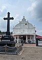
 Marth Mariyam Jacobite Syrian Sonoroo Cathedral Great Church, is a Jacobite Church Situated In The Centre Of The City Of Kothamangalam
 -
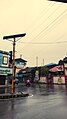 Rainy Evening in the city Of Kothamangalam In the month of June
 -
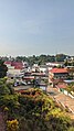
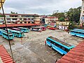 Aerial view of kothamangalam Private Bus Stand On A Evening
 -
 Bhoothathankettu Dam On A Rainy Evening
 -
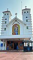
 St. George's Cathedral, is a Catholic Church In The Centre Of Kothamangalam City
 -
 Revenue Tower Of Kothamangalam Near the Private Bus Stand
 -
 Aerial view of kothamangalam Cheriya palli


Villages
[edit]- Chathamattam
- Nellikuzhi
- Keerampara
- Kottappady
- Kuttampuzha
- Neriamangalam
- Pindimana
- Pothanikkad
- Thrikkariyoor
- Varappetty
References
[edit]- ^ https://lsgkerala.gov.in/system/files/2017-10/localbodies.pdf [bare URL PDF]
- ^ "Kerala (India): Districts, Cities and Towns - Population Statistics, Charts and Map".
- ^ https://lsgkerala.gov.in/system/files/2017-10/localbodies.pdf [bare URL PDF]
- ^ Eranakulam. Kerala Government Statistics
- ^ Journal of South Indian History. Publication Division, University of Calicut. 2005. pp. 84–85.
- ^ In Quest of Kerala: Geography, places of interest, political history, social history, literature. Accent Publications. 1974. p. 57.
- ^ "Population by Religious Community". Census of India. Archived from the original on 13 September 2015. Retrieved 28 March 2018.
- ^ [. Census2011.co.in. Retrieved on 2015-04-19.
- ^ Kothamangalam Block. Ernakulam.nic.in. Retrieved on 2015-04-19.
- ^ "Assembly Constituencies – Corresponding Districts and Parliamentary Constituencies" (PDF). Kerala. Archived from the original (PDF) on 30 October 2008. Retrieved 19 October 2008.
External links
[edit]| Districts |
|  |
|---|---|---|
| Towns and cities |
| |