
Autonomous Republic of Crimea: Difference between revisions
m Updating {{cite web}} templates: replaced 'accessdaymonth/monthday/year' parameters with 'accessdate' and 'dateformat' |
No edit summary |
||
| Line 168: | Line 168: | ||
[[Image:Flag of the Crimean Tatar people.PNG|thumb|Flag of the [[Crimean Tatars]], sporting the traditional [[Tamgha|tamğa]].]] |
[[Image:Flag of the Crimean Tatar people.PNG|thumb|Flag of the [[Crimean Tatars]], sporting the traditional [[Tamgha|tamğa]].]] |
||
Another centre of conflict on the peninsula is regarding land ownership. Since the Crimean Tatars were forcibly deported from their homeland in May 1944, other people, particularly [[Russians]], settled the peninsula and took control of the lands formerly belonging to the Crimean Tatars. After the fall of the Soviet Union, Crimean Tatars were allowed to return to Crimea, but conflict arose when they demanded the return of land seized after their deportation.<ref>{{cite web|url=http://www.todayszaman.com/tz-web/detaylar.do?load=detay&link=106815 |title=Tatars push to regain their historic lands in Crimea | dateformat=mdy |accessdate=March 31 2007 |date= |year=2006 |month=March 31 |work=Today's Zaman }}</ref> |
Another centre of conflict on the peninsula is regarding land ownership. Since the Crimean Tatars were forcibly deported from their homeland by [[Stalin]] in May 1944, other people, particularly [[Russians]], settled the peninsula and took control of the lands formerly belonging to the Crimean Tatars. After the fall of the Soviet Union, Crimean Tatars were allowed to return to Crimea, but conflict arose when they demanded the return of land seized after their deportation.<ref>{{cite web|url=http://www.todayszaman.com/tz-web/detaylar.do?load=detay&link=106815 |title=Tatars push to regain their historic lands in Crimea | dateformat=mdy |accessdate=March 31 2007 |date= |year=2006 |month=March 31 |work=Today's Zaman }}</ref> |
||
==Government and politics== |
==Government and politics== |
||
Revision as of 22:14, 4 February 2009
Autonomous Republic of Crimea Автономная Республика Крым Автономна Республіка Крим Qırım Muhtar Cumhuriyeti | |
|---|---|
| Motto: Процветание в единстве (Russian) Protsvetanie v edinstve (transliteration) "Prosperity in unity" | |
| Anthem: Нивы и горы твои волшебны, Родина (Russian) Nivy i gory tvoi volshebny, Rodina (transliteration) Your fields and mounts are wonderful, Motherland | |
 Location of Crimea (red) with respect to Ukraine (light blue). | |
 Location of Crimea (dark green) with respect to Ukraine (light green) on a map of Europe. | |
| Capital and largest city | Simferopol |
| Official languages | Ukrainian1 |
| Recognised regional languages | Russian, Crimean Tatar |
| Ethnic groups (2001) | 58.32% Russians 24.32% Ukrainians 12.10% Crimean Tatars |
| Government | Autonomous republic within Ukraine |
| Viktor Yushchenko2 | |
| Viktor Plakida | |
| Anatoliy Hrytsenko | |
| Legislature | Verkhovna Rada (Crimea) |
| Autonomy from the Russian Empire / Soviet Union | |
• Declared | October 18 1921 |
| June 30 1945 | |
• Restored3 | February 12 1992 |
• Constitution | October 21 1998 |
| Area | |
• Total | 26,100 km2 (10,100 sq mi) (148th) |
| Population | |
• 2007 estimate | 1,973,185 (148th) |
• 2001 census | 2,033,700 |
• Density | 75.6/km2 (195.8/sq mi) (116th) |
| Currency | Ukrainian hryvnia (UAH) |
| Time zone | UTC+2 (EET) |
• Summer (DST) | UTC+3 (EEST) |
| Calling code | +3805 |
| Internet TLD | crimea.ua4 |
| |


Crimea (/kraɪˈmiːə/) or the Autonomous Republic of Crimea ([Крим, Автономна Республіка Крим, Avtonomna Respublika Krym] Error: {{Lang-xx}}: text has italic markup (help); Russian: Крым, Автономная Республика Крым; Crimean Tatar: Qırım, Qırım Muhtar Cumhuriyeti) is an autonomous republic of Ukraine located on the northern coast of the Black Sea, occupying a peninsula of the same name.
The territory of Crimea was conquered and controlled many times throughout its history. The Cimmerians, Greeks, Persians (Iranians), Goths, Huns, Bulgars, Khazars, the state of Kievan Rus', Byzantine Greeks, Kipchaks, and the Mongols all controlled Crimea in its early history. In the 13th century it was partly controlled by the Venetians and by the Genoese; these were followed by the Crimean Khanate and Ottoman Empire in the 15th–18th centuries, the Russian Empire in the 18th–20th centuries, the Russian SFSR and later Ukrainian SSR within Soviet Union in the rest of 20th century, Germany in World War II, and now, the independent Ukrainian state.
Crimea is a parliamentary republic which is governed by the Constitution of Crimea in accordance with the laws of Ukraine. The capital and administrative seat of the republic's government is the city of Simferopol, located in the center of the peninsula. Crimea's total area is 26,200 square kilometres (10,100 sq mi). As of 2007, Crimea has a population of 1,973,185 inhabitants.
Crimea was originally occupied by the Crimean Tatars, an ethnic minority who now make up about 13% of the population. The Crimean Tatars were forcibly expelled to Central Asia by Joseph Stalin's government. After the fall of the Soviet Union some Crimean Tatars began returning to the region.[1]
Etymology of the name
The name Crimea takes its origin in the name of a city of Qırım (today's Stary Krym) which served as a capital of the Crimean province of the Golden Horde. Qırım is Crimean Tatar for "my hill" (qır – hill, -ım – my). However, there are other versions of the etymology of Qırım. Russian Krym is a Russified form of Qırım. The ancient Greeks called Crimea Tauris (later Taurica), after its inhabitants, the Tauri. The Greek historian Herodotus mentions that Heracles plowed that land using a huge ox ("Taurus"), hence the name of the land, and thereby asserting that these people named their land, and hence themselves, after an ox used by a mythical, Greek figure.
In English, Crimea is sometimes referred to with the definite article, the Crimea, as in the Netherlands, the Gambia, etc. However, usage without the article has become more frequent in journalism since the years of the Soviet Union.
History
Early history
The earliest inhabitants of whom we have any authentic traces were the Cimmerians, who were expelled by the Scythians (Iranians) during the 7th century BC. The remaining Cimmerians that took refuge in the mountains later became known as the Tauri. According to other historians, the Tauri were known for their savage rituals and piracy, and were also the earliest indigenous peoples of the peninsula. In 5th century BC, Greek colonists began to settle along the Black Sea coast, among those were the Dorians from Heraclea who founded a sea port of Chersonesos outside Sevastopol, and the Ionians from Miletus who landed at Feodosiya and Panticapaeum (also called Bosporus).

Two centuries later (438 BC), the Archon (ruler) of the latter settlers assumed the title of the Kings of Cimmerian Bosporus, a state that maintained close relations with Athens, supplying the city with wheat, honey and other commodities. The last of that line of kings, Paerisades V, being hard-pressed by the Scythians, put himself under the protection of Mithridates VI, the king of Pontus, in 114 BC. After the death of this sovereign, his son, Pharnaces II, was invested by Pompey with the kingdom of Bosporus in 63 BC as a reward for the assistance rendered to the Romans in their war against his father. In 15 BC, it was once again restored to the king of Pontus, but since ranked as a tributary state of Rome.
Throughout the later centuries, Crimea was invaded or occupied successively by the Goths (AD 250), the Huns (376), the Bulgars 4th-8th century), the Khazars (8th century), the state of Kievan Rus' (10th–11th centuries), the Byzantine Empire (1016), the Kipchaks (the Kumans) (1050), and the Mongols (1237).
In the mid-10th century, the eastern area of Crimea was conquered by Prince Sviatoslav I of Kiev and became part of the Kievan Rus' principality of Tmutarakan. In 988, Prince Vladimir I of Kiev also captured the Byzantine town of Chersones (presently part of Sevastopol) where he later converted to Christianity. An impressive Russian Orthodox cathedral marks the location of this historic event.
In the 13th century, the Republic of Genoa seized the settlements which their rivals, the Venetians, had built along the Crimean coast and established themselves at Cembalo, Soldaia, Cherco and Caffa, gaining control of the Crimean economy and the Black Sea commerce for two centuries.
Crimean Khanate: 1441-1783
A number of Turkic peoples, now collectively known as the Crimean Tatars, have been inhabiting the peninsula since the early Middle Ages. The ethnicity of the Crimean Tatars is quite complex as it absorbed both nomadic Turkic and European components (in the first place, the Goths and the Genoese) which is still reflected in their appearance and language differences. A small enclave of the Karaims, possibly of Khazar (i.e. Turkic) descent but members of a Jewish sect, was founded in the 8th century. It existed among the Muslim Crimean Tatars, primarily in the mountainous Çufut Qale area.
After the destruction of the Golden Horde by Timur in 1441, the Crimean Tatars founded an independent Crimean Khanate under Hacı I Giray, a descendant of Genghis Khan. He and his successors reigned first at Qırq Yer, and from the beginning of the 15th century, at Bakhchisaray.[2]
The Crimean Tatars controlled the steppes that stretched from the Kuban and to the Dniester River, however, they were unable to take control over commercial Genoese towns. After the Crimean Tatars asked for help from the Ottomans, an Ottoman invasion of the Genoese towns led by Gedik Ahmed Pasha in 1475 brought Kaffa and the other trading towns under their control.[3]
After the capture of Genoese towns, the Ottoman Sultan held Meñli I Giray captive,[4] later releasing him in return for accepting Ottoman sovereignty above the Crimean Khans and allowing them rule as tributary princes of the Ottoman Empire.[3][5] However, the Crimean Khans still had a large amount of autonomy from the Ottoman Empire, particularly, followed the rules they thought were best for them: Crimean Tatars introduced raids into Ukrainian lands, which were used to get slaves to be sold on markets.[3]
In 1553–1554, Cossack Hetman Dmytro Vyshnevetsky gathered together groups of Cossacks, and constructed a fort designed to obstruct Tatar raids into Ukraine. With this action, he founded the Zaporozhian Sich, with which he would launch a series of attacks on the Crimea peninsula and the Ottoman Turks.[6] In 1774, The Crimean Khans fell under Russian influence with the Treaty of Küçük Kaynarca.[7] In 1783, the entire Crimea was annexed by the Russian Empire.[8]
Russian Empire and Civil War: 1783-1922
_2007.JPG)
The Crimean War (1853–1856) devastated much of the economic and social infrastructure of Crimea. The Crimean Tatars had to flee from their homeland en masse, forced by the conditions created by the war, persecution and land expropriations. Those who survived the trip, famine and disease, resettled in Dobruja, Anatolia, and other parts of the Ottoman Empire. Finally, the Russian government decided to stop the process, as the agriculture began to suffer due to the unattended fertile farmland.
During the Russian Civil War, Crimea was a stronghold of the anti-Bolshevik White Army, including the Crimean People's Republic. It was in Crimea that the White Russians led by General Wrangel made their last stand against Nestor Makhno and the Red Army in 1920. After the resistance was crushed, many of the anti-Communist fighters and civilians had to board the ships and escape to Istanbul.
Soviet Union: 1922-1991
On October 18, 1921, the Crimean Autonomous Soviet Socialist Republic was created as part of the Russian SFSR.[5] However, this did not protect the Crimean Tatars, who constituted about 25% of the Crimean population[9], from Joseph Stalin's repressions of the 1930s.[5] The Greeks were another cultural group that suffered. Their lands were lost during the process of collectivisation, in which farmers were not compensated with wages. Schools which taught Greek were closed and Greek literature was destroyed, because the Soviets considered the Greeks as "counter-revolutionary" with their links to capitalist state Greece, and their independent culture.[5]
Crimea experienced two severe famines in the 20th century, the Famine of 1921-1922 and the Holodomor of 1932-1933.[10]
During World War II, Crimea was a scene of some of the bloodiest battles. The leaders of the Third Reich were anxious to conquer and colonize the fertile and beautiful peninsula as part of their policy of resettling the Germans in Eastern Europe at the expense of the Slavs. The Germans suffered heavy casualties in the summer of 1941 as they tried to advance through the narrow Isthmus of Perekop linking Crimea to the Soviet mainland. Once the German army broke through (Operation Trappenjagd), they occupied most of Crimea, with the exception of the city of Sevastopol, which was later awarded the honorary title of Hero City after the war.

Sevastopol held out from October 1941 until July 4, 1942 when the Germans finally captured the city. From September 1, 1942, the peninsula was administered as the Generalbezirk Krim (general district of Crimea) und Teilbezirk (and sub-district) Taurien by the Nazi Generalkommissar Alfred Eduard Frauenfeld (1898–1977), under the authority of the three consecutive Reichskommissare for the entire Ukraine. In spite of heavy-handed tactics by the Nazis and the assistance of the Romanian and Italian troops, the Crimean mountains remained an unconquered stronghold of the native resistance (the partisans) until the day when the peninsula was freed from the occupying force.
In 1944, Sevastopol came under the control of troops from the Soviet Union. The so-called "City of Russian Glory" once known for its beautiful architecture was entirely destroyed and had to be rebuilt stone by stone. Due to its enormous historical and symbolic meaning for the Russians, it became a priority for Stalin and the Soviet government to have it restored to its former glory within the shortest time possible.
On May 18, 1944, the entire population of the Crimean Tatars were forcibly deported in the "Sürgün" (Crimean Tatar for exile) to Central Asia by Stalin's Soviet government as a form of collective punishment on the grounds that they had collaborated with the Nazi occupation forces.[11] An estimated 46% of the deportees died from hunger and disease. On June 26 of the same year Armenian, Bulgar and Greek population was also deported to Central Asia. By the end of summer 1944, the ethnic cleansing of Crimea was complete. In 1967, the Crimean Tatars were rehabilitated, but they were banned from legally returning to their homeland until the last days of the Soviet Union.
The Crimean Autonomous Soviet Socialist Republic was abolished in June 30, 1945 and transformed into the Crimean Oblast (province) of the Russian SFSR. On February 19, 1954, the oblast was transferred from the Russian SFSR to the Ukrainian SSR. As it stated in the Supreme Soviet Decree, the transfer was caused by close (1) geographic, (2) economic, and (3) cultural ties to the Ukrainian SSR.[12]
In post-war years, Crimea thrived as a prime tourist destination, built with new attractions and sanatoriums for tourists. Tourists came from all around the Soviet Union and neighbouring countries, particularly from the German Democratic Republic.[5] Also, Crimea's infrastructure and manufacturing also developed, particularly around the sea ports at Kerch and Sevastopol and in the oblast's landlocked capital, Simferopol. Populations of Ukrainians and Russians alike doubled, with more than 1.6 million Russians and 626,000 Ukrainians living on the peninsula by 1989.[5]
Autonomy within independent Ukraine
.jpg)
With the collapse of the Soviet Union, Crimea became part of the newly independent Ukraine, a situation largely unexpected by its population that was ethnically and culturally Russian for the most part.[citation needed] This led to tensions between Russia and Ukraine. With the Black Sea Fleet based on the peninsula, worries of armed skirmishes were occasionally raised.
After the All-Crimean Referendum was conducted on January 20, 1991, the Crimean Oblast was transformed into the Crimean ASSR as part of the Ukrainian SSR and the city of Sevastopol was granted special government status in the USSR.[13] In the Ukrainian referendum on independence on December 1, 1991, 54.19% of residents from Crimea and 57.07% from Sevastopol city voted in favor of Ukrainian independence.[14][15]
Based on the resolution of the Verkhovna Rada (the Crimean parliament) on February 26, 1992, the Crimean ASSR was renamed the Republic of Crimea. Crimea proclaimed self-government on May 5, 1992[16][17] and on the next day passed the first Crimean constitution.
On May 19, Crimea agreed to remain as part of Ukraine and annulled their proclamation of self-government. By June 30, Crimean Communists forced the Kiev government to expand on the already extensive autonomous status of Crimea.[18] In the same period, Russian president Boris Yeltsin and Ukraine's Leonid Kravchuk agreed to divide the former Soviet Black Sea Fleet between Russia and the newly-formed Ukrainian Navy.[19]
On October 14, 1993, Crimea established the post of President of Crimea. On January 30, 1994, the pro-Russian Yuriy Meshkov was elected to the new post but quickly ran into conflicts with parliament. On September 7, the Crimean parliament annulled the President's rights, to which Meshov responded by disbanding parliament and announcing his control over Crimea four days later. Amendments[clarification needed] to the constitution eased the conflict[citation needed], but on March 17, 1995, the parliament of Ukraine intervened, scrapping the Crimean Constitution and removing Meshkov along with his office.[20] After a interim constitution lasting from April 4, 1996, to December 23, 1998, the currently existing constitution was put into effect, changing the territory's name to the Autonomous Republic of Crimea.
Following the ratification of the May 1997 Treaty of Friendship, Cooperation, and Partnership on friendship and division of the Black Sea Fleet, international tensions slowly eased off. With the treaty, Moscow recognized Ukraine's borders and territorial integrity, and accepted Ukraine's sovereignty over Crimea and Sevastopol.[21] In a separate agreement, Russia was to receive 80% of the Black Sea Fleet and use of the military facilities in Sevastopol on a 20-year lease.[21]
However, other controversies between Ukraine and Russia still remain, including the ownership of a lighthouse on Cape Sarych. Because the Russian Navy controlled 77 geographical objects on the south Crimean Shore, the Sevastopol Government Court ordered the vacating of the objects, which the Russian military did not carry out.[22] Since August 3, 2005, the lighthouse has been controlled by the Russian Army.[23] Through the years, there have been various attempts to return Cape Sarych to Ukrainian territory, all of which were unsuccessful.

In 2006, protests broke out on the peninsula after U.S. Marines[24] arrived at the Crimean city of Feodosiya to take part in the Sea Breeze 2006 Ukraine-NATO military exercise. Protesters greeted the marines with barricades and slogans bearing "Occupiers go home!" and a couple days later, the Crimean parliament declared Crimea a "NATO-free territory." After several days of protest, the U.S. Marines withdrew from the peninsula.[25]
In September 2008, the Ukrainian Foreign Minister Volodymyr Ohryzko accused Russia of giving out Russian passports to the population in the Crimea and described it as a "real problem" given Russia's declared policy of military intervention abroad to protect Russian citizens.[26]
Return of Crimean Tatars

Another centre of conflict on the peninsula is regarding land ownership. Since the Crimean Tatars were forcibly deported from their homeland by Stalin in May 1944, other people, particularly Russians, settled the peninsula and took control of the lands formerly belonging to the Crimean Tatars. After the fall of the Soviet Union, Crimean Tatars were allowed to return to Crimea, but conflict arose when they demanded the return of land seized after their deportation.[27]
Government and politics

Crimea is a parliamentary republic that has no president. The legislative body is a 100-seat parliament, the Verkhovna Rada of Crimea.[28]
The executive power is represented by the Council of Ministers, headed by a Prime Minister who is appointed and dismissed by the Verkhovna Rada, with the consent of the President of Ukraine.[29] The authority and operation of the Verkhovna Rada and the Council of Ministers of Crimea are determined by the Constitution of Ukraine and other the laws of Ukraine, as well as by regular decisions carried out by the Verkhovna Rada of Crimea.[29]
Justice is administered by courts that belong to the judicial system of Ukraine.[29]
Elections and parties
While not an official body controlling Crimea, the Mejlis of the Crimean Tatar People is a representative body of the Crimean Tatars, which could address grievances to the Ukrainian central government, the Crimean government, and international bodies.[30]
During the 2004 presidential elections, Crimea largely voted for the presidential candidate Viktor Yanukovych. In both the 2006 Ukrainian parliamentary elections and the 2007 Ukrainian parliamentary elections, the Yanukovych-led Party of Regions also won most of the votes from the region.
Following the Crimean parliamentary election, 2006, the following political parties are represented in the Verkhovna Rada bloc: "Za Yanukovycha!" (Party of Regions and the Russian Bloc): 32.55% (44 mandates); party "Soiuz": 7.63% (10 mandates); Kunytsyna Electoral Bloc: 7.63% (10 mandates); Communist Party of Ukraine: 6.55% (9 mandates); People's Movement of Ukraine: 6.26% (8 mandates); Yulia Tymoshenko Electoral Bloc: 6.03% (8 mandates); People's Opposition Bloc of Natalia Vitrenko: 4.97% (7 mandates); Opposition Bloc "Ne Tak": 3.09% (4 mandates).[31]
Administrative divisions
Crimea is subdivided into 25 regions: 14 raions (districts) and 11 city municipalities, officially known as "territories governed by city councils".[32] While the City of Sevastopol is located on the Crimean peninsula, it is administratively separate from the rest of Crimea and is one of two special municipalities of Ukraine.
Raions

|
City municipalities
Major cities
|
|
Geography and Climate

Crimea is located on the northern coast of the Black Sea and on the western coast of the Sea of Azov, bordering Kherson Oblast from the North. Although located in the southwestern part of the Crimean peninsula, the city of Sevastopol has a special but separate municipality status within Ukraine. Crimea's total land area is 26,100 km² (10,038 sq mi).
Crimea is connected to the mainland by the 5–7 kilometre (3–4 mi) wide Isthmus of Perekop. At the eastern tip is the Kerch Peninsula, which is directly opposite the Taman Peninsula on the Russian mainland. Between the Kerch and Taman peninsulas, lies the 3–13 km (2–9 mi) wide Strait of Kerch, which connects the waters of the Black Sea with the Sea of Azov.
The Crimean coastline is broken by several bays and harbors. These harbors lie west of the Isthmus of Perekop by the Bay of Karkinit; on the southwest by the open Bay of Kalamita, with the ports of Eupatoria and Sevastopol; on the north by the Bay of Arabat of the Isthmus of Yenikale or Kerch; and on the south by the Bay of Caffa or Feodosiya, with the port of Feodosiya.
The southeast coast is flanked at a distance of 8–12 km (5–8 mi) from the sea by a parallel range of mountains, the Crimean Mountains.[33] These mountains are backed by secondary parallel ranges. Seventy-five percent of the remaining area of Crimea consists of semiarid prairie lands, a southward continuation of the Pontic steppes, which slope gently to the northwest from the foot of the Crimean Mountains. The main range of these mountains shoots up with extraordinary abruptness from the deep floor of the Black Sea to an altitude of 600–750 metres (2,000–2,500 ft), beginning at the southwest point of the peninsula, called Cape Fiolente. It was believed that this cape was supposedly crowned with the temple of Artemis, where Iphigeneia is said to have officiated as priestess.[34] Uchan-su waterfall on the south slope of the mountains is the highest in Ukraine.

Numerous kurgans, or burial mounds, of the ancient Scythians are scattered across the Crimean steppes.
The terrain that lies beyond the sheltering Crimean Mountain range is of an altogether different character. Here, the narrow strip of coast and the slopes of the mountains are smothered with greenery. This "riviera" stretches along the southeast coast from Cape Sarych, in the extreme south, to Feodosiya, and is studded with summer sea-bathing resorts such as Alupka, Yalta, Gurzuf, Alushta, Sudak, and Feodosiya. During the years of Soviet rule, the resorts and dachas of this coast served as the prime perquisites of the politically loyal. In addition, vineyards and fruit orchards are located in the region. Fishing, mining, and the production of essential oils are also important. Numerous Crimean Tatar villages, mosques, monasteries, and palaces of the Russian imperial family and nobles are found here, as well as picturesque ancient Greek and medieval castles.
Most of Crimea has a temperate continental climate, except for the south coast where it experiences a humid subtropical climate, due to warm influences from the Black Sea. Summers can be hot (28 °C (82 °F)* Jul average) and winters are cool (−0.3 °C (31.5 °F)* Jan average) in the interior, on the south coast winters are milder (4 °C (39 °F)* Jan average) and temperatures much below freezing are exceptional. Precipitation in the interior is low with only 400 mm (16 in) a year. On the south coast precipitation is more than double of that, Yalta annually receives about 1,050 mm (41 in). Because of its climate, the southern Crimean coast is a popular beach and sun resort for Ukrainian and Russian tourists.
Places of interest
- Livadia Palace
- Mount Mithridat
- Scyth's treasure
- Swallow's Nest
- Tauric Chersonesos
- Vorontsov's Palace (Alupka)
Economy
The main branches of the Crimean economy are tourism and agriculture. Industrial plants are situated for the most part in the northern regions of the republic. Important industrial cities include Dzhankoy, housing a major railway connection, and Krasnoperekopsk, among others.
The most important industries in Crimea include food production, chemical fields, mechanical engineering and metal working, and fuel production industries.[29] Sixty percent of the industry market belongs to food production. There are a total of 291 large industrial enterprises and 1002 small business enterprises.[29]
The main branches of vegetation production in the region include cereals, vegetable-growing, gardening, and wine-making, particularly in the Yalta and Massandra regions. Other agricultural forms include cattle breeding, poultry keeping, and sheep breeding.[29] Other products produced on the Crimea Peninsula include salt, porphyry, limestone, and ironstone (found around Kerch).[35]
Transport
Almost every settlement in Crimea is connected with another settlement with bus lines. Crimea contains the longest (96 km or 59 mi) trolleybus route in the world, stretching from Simferopol to Yalta.[36] The trolleybus line starts in near Simferopol's Railway Station through the mountains to Alushta and on to Yalta.
The cities of Yalta, Feodosiya, Kerch, Sevastopol, Chornomorske, and Yevpatoria are connected to one another by sea routes. In the cities of Yevpatoria and nearby townlet Molochnoye are tram systems. Railroad lines running through Crimea include Armyansk—Kerch (with a link to Feodosiya), and Melitopol—Sevastopol (with a link to Yevpatoria), connecting Crimea to the Ukrainian mainland.
Demographics
| Part of a series on |
| Crimean Tatars |
|---|
| By region or country |
| Religion |
| Language |
| Culture |
| History |
| People and groups |
As of 2005, the total population of Crimea is 1,994,300.
From 1989 to 2001, Crimea's population declined by 396,795 people, representing 16.33% of the 1989 population, despite the return of displaced groups such as Crimean Tatars. From 2001-2005 the population declined by another 39,400 people, representing a decline from 2001 of another 2%.
According to 2001 Ukrainian Census, the population of Crimea was 2,033,700.[37] The ethnic makeup was comprised the following self-reported groups: Russians: 52.32%; Ukrainians: 24.32%; Crimean Tatars: 18.1%; Belarusians: 1.44%; Tatars: 0.54%; Armenians: 0.43%; and Jews: 0.22%.[38]
Other minorities are Black Sea Germans, Roma people, Bulgarians, Poles, Azerbaijanis, Koreans and Greeks.
Ukrainian language is the single official state language countrywide, and is the sole language of government in Ukraine. In Crimea government business is still carried out mainly in Russian. Attempts to expand the usage of Ukrainian in education and government affairs has been less successful in Crimea than in other areas of the nation. [39] Another language widely spoken is Crimean Tatar. According to the census mentioned, 77% of Crimean inhabitants named Russian as their native language; 11.4% – Crimean Tatar; and 10.1% – Ukrainian.[40]
Currently 2/3 of the migrants into Crimea are from Ukraine, every 5th is from the former Soviet Union and every 40th from outside of the former Soviet Union. 3/4 of those leaving Crimea move to other areas in Ukraine. Every 20th migrates to the West[40].
Trends
The population of the Crimean peninsula has been consistently falling at a rate of 0.4% per year[41]. This is particularly apparent in both the Russian and Ukrainian ethnic populations, whose growth rate has been falling at the rate of 0.6% and 0.12% annually respectively. In comparison, the overall growth rate of the ethnic Crimean Tatar population has been growing at the rate of 0.9% per annum[42].
The growing trend in the Crimean Tatar population has been explained by the continual Crimean Tatar repatriation (mainly Uzbekistan), the high birth rate amongst the resettlers, and the low death rate as few senior citizens have resettled back into their ancestral home.
Culture
Sport
Crimea is a prominent figure in Ukrainian sports, especially the most popular: Association football. The most successful Crimean football club is Tavriya Simferopol in the Ukrainian Premier League possessing one championship title. In the Ukrainian First League Crimea is represented by FC Feniks-Illychovets Kalinine, FC Ihroservice Simferopol, FC Krymteplitsia Molodizhne, PFC Sevastopol. In the Second League Crimea has the club FC Tytan Armyansk.
See also

Footnotes and references
This article needs additional citations for verification. (August 2008) |
- ^ Pohl, J. Otto. The Stalinist Penal System: A Statistical History of Soviet Repression and Terror. Mc Farland & Company, Inc, Publishers. 1997. 23.
- ^ The Tatar Khanate of Crimea
- ^ a b c Subtelny, Orest (2000). Ukraine: A History. University of Toronto Press. p. 78. ISBN 0-8020-8390-0.
- ^ Soldier Khan
- ^ a b c d e f "History". blacksea-crimea.com. Retrieved March 28 2007.
{{cite web}}: Check date values in:|accessdate=(help); Unknown parameter|dateformat=ignored (help) Cite error: The named reference "blacksea-crimea/hist" was defined multiple times with different content (see the help page). - ^ Subtelny, 109.
- ^ Subelny, 176.
- ^ Subelny, 176.
- ^ Crimea: History
- ^ Famine in Crimea
- ^ Subtelny, 483.
- ^ "The Transfer of Crimea to Ukraine". International Committee for Crimea. 2005. Retrieved March 25 2007.
{{cite web}}: Check date values in:|accessdate=(help); Unknown parameter|dateformat=ignored (help); Unknown parameter|month=ignored (help) - ^ "Day in history - 20 January". RIA Novosti (in Russian). 2006. Retrieved August 6 2007.
{{cite web}}: Check date values in:|accessdate=(help); Unknown parameter|dateformat=ignored (help); Unknown parameter|month=ignored (help) - ^ Subtelny, 585.
- ^ Lalpychak, Chrystyna (1991). "Ukraine's vote for freedom". The Ukrainian Weekly. Retrieved March 25 2007.
{{cite web}}: Check date values in:|accessdate=(help); Unknown parameter|dateformat=ignored (help); Unknown parameter|month=ignored (help) - ^ Wolczuk, Kataryna (2004). "Catching up with 'Europe'? Constitutional Debates on the Territorial-Administrative Model in Independent Ukraine". Taylor & Francis Group. Retrieved December 16 2006.
{{cite web}}: Check date values in:|accessdate=(help); Unknown parameter|dateformat=ignored (help); Unknown parameter|month=ignored (help) - ^ Wydra, Doris (2004). "The Crimea Conundrum: The Tug of War Between Russia and Ukraine on the Questions of Autonomy and Self-Determination". SpringerLink. Retrieved March 25 2007.
{{cite web}}: Check date values in:|accessdate=(help); Unknown parameter|dateformat=ignored (help); Unknown parameter|month=ignored (help) - ^ Subtelny, 587.
- ^ Ready To Cast Off, TIME Magazine, June 15, 1992
- ^ Laws of Ukraine. Verkhovna Rada law No. 93/95-вр: On the termination of the Constitution and some laws of the Autonomous Republic of Crimea. Adopted on 1995-03-17. (Ukrainian)
- ^ a b Subtelny, 600.
- ^ "Access to Ukrainians is prohibited". Zakryta Zona (in Ukrainian). Retrieved February 24 2007.
{{cite web}}: Check date values in:|accessdate=(help); Unknown parameter|dateformat=ignored (help) - ^ "The owner of the "sarych" lighthouse came back with a blank document to the President of Ukraine". CPCFPU (in Ukrainian). Retrieved February 24 2007.
{{cite web}}: Check date values in:|accessdate=(help); Unknown parameter|dateformat=ignored (help) - ^ Page, Jeremy (June 8 2006). "Anti-Nato protests threaten eastward expansion". The Times Online. Retrieved March 25 2007.
{{cite web}}: Check date values in:|accessdate=and|date=(help); Cite has empty unknown parameter:|month=(help); Unknown parameter|dateformat=ignored (help) - ^ "Tensions rise in Crimea over NATO". EuroNews. 2006. Retrieved March 25 2007.
{{cite web}}: Check date values in:|accessdate=(help); Unknown parameter|dateformat=ignored (help); Unknown parameter|month=ignored (help) - ^ Cheney urges divided Ukraine to unite against Russia 'threat. Associated Press. September 6, 2008.
- ^ "Tatars push to regain their historic lands in Crimea". Today's Zaman. 2006. Retrieved March 31 2007.
{{cite web}}: Check date values in:|accessdate=(help); Unknown parameter|dateformat=ignored (help); Unknown parameter|month=ignored (help) - ^ The Verkhovna Rada of Crimea should not be confused with the national Verkhovna Rada of Ukraine.
- ^ a b c d e f "Autonomous Republic of Crimea - Information card". Cabinet of Ministers of Ukraine. Retrieved February 22 2007.
{{cite web}}: Check date values in:|accessdate=(help); Unknown parameter|dateformat=ignored (help) - ^ Ziad, Waleed (2007). "A lesson in stifling violent extremism". CS Monitor. Retrieved March 26 2007.
{{cite web}}: Check date values in:|accessdate=(help); Unknown parameter|coauthors=ignored (|author=suggested) (help); Unknown parameter|dateformat=ignored (help); Unknown parameter|month=ignored (help) - ^ "Results of the Verkhovna Rada of Crimea elections are accepted". REGNUM (in Russian). 2006. Retrieved April 28 2007.
{{cite web}}: Check date values in:|accessdate=(help); Unknown parameter|dateformat=ignored (help); Unknown parameter|month=ignored (help) - ^ "Infobox card — Avtonomna Respublika Krym". Verkhovna Rada of Ukraine (in Ukrainian). Retrieved February 23 2007.
{{cite web}}: Check date values in:|accessdate=(help); Unknown parameter|dateformat=ignored (help) - ^ The Crimean Mountains may also be referred to as the Yaylâ Dağ or Alpine Meadow Mountains.
- ^ See the article "Crimea" in the Encyclopædia Britannica Eleventh Edition.
- ^ Bealby, John T. (1911). Encyclopædia Britannica Eleventh Edition. Cambridge University Press. p. 449.
- ^ "The longest trolleybus line in the world!". blacksea-crimea.com. Retrieved January 15 2007.
{{cite web}}: Check date values in:|accessdate=(help); Unknown parameter|dateformat=ignored (help) - ^ "Regions of Ukraine / Autonomous Republic of Crimea". 2001 Ukrainian Census. Retrieved December 16 2006.
{{cite web}}: Check date values in:|accessdate=(help); Unknown parameter|dateformat=ignored (help) - ^ "Results / General results of the census / National composition of population". 2001 Ukrainian Census. Retrieved December 16 2006.
{{cite web}}: Check date values in:|accessdate=(help); Unknown parameter|dateformat=ignored (help) - ^ Bondaruk, Halyna (2007). "Yushchenko Appeals to Crimean Authority Not to Speculate on Language". Ukrayinska Pravda. Retrieved March 25 2007.
{{cite web}}: Check date values in:|accessdate=(help); Unknown parameter|dateformat=ignored (help); Unknown parameter|month=ignored (help) - ^ a b "Results / General results of the census / Linguistic composition of the population / Autonomous Republic of Crimea". 2001 Ukrainian Census. Retrieved December 16 2006.
{{cite web}}: Check date values in:|accessdate=(help); Unknown parameter|dateformat=ignored (help) - ^ Falling Population growth rate in Crimea (in Ukrainian)
- ^ Population growth in Crimea (in Ukrainian)
- Subtelny, Orest (2000). Ukraine: A History. University of Toronto Press. p. 78. ISBN 0-8020-8390-0.
- "Autonomous Republic of Crimea - Information card". Cabinet of Ministers of Ukraine. Retrieved February 22 2007.
{{cite web}}: Check date values in:|accessdate=(help); Unknown parameter|dateformat=ignored (help) - This article incorporates text from a publication now in the public domain: Chisholm, Hugh, ed. (1911). Encyclopædia Britannica (11th ed.). Cambridge University Press.
{{cite encyclopedia}}: Missing or empty|title=(help)
External links
 Definitions from Wiktionary
 Media from Commons
 News from Wikinews
 Quotations from Wikiquote
 Texts from Wikisource
 Textbooks from Wikibooks
 Resources from Wikiversity
Official links
- crimea-portal.gov.ua — Official portal of the Council of Ministers of Crimea Template:En icon/Template:Uk icon/Template:Ru icon/Template:Fr icon
- rada.crimea.ua — Official web-site of the Verkhovna Rada of Crimea
Informational links
- Cabinet of Ministers of Ukraine — Information card of the region
- WikiTravel — Guide to Crimea
- [1]- tours Package in Crimea
 Wikimedia Atlas of Crimea
- United Nations Crimea Integration and Development Programme
- Crimea Tourism
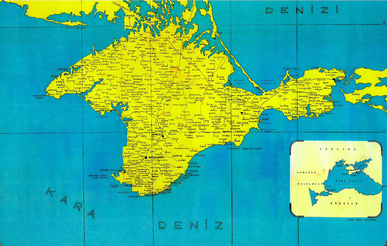
- Maps of all Crimea cities, towns and villages
- Old map of Crimea
- List of hotels with contacts
Geographic locale | |||||||||||||||||||
|---|---|---|---|---|---|---|---|---|---|---|---|---|---|---|---|---|---|---|---|
| |||||||||||||||||||

.jpg)