
Bidar Fort: Difference between revisions
→See also: Added QRpedia template |
|||
| Line 368: | Line 368: | ||
* [[Basavakalyana Fort]] |
* [[Basavakalyana Fort]] |
||
* [[Mudgal|Mudgal Fort]] |
* [[Mudgal|Mudgal Fort]] |
||
{{QRpedia article}} |
|||
==External links== |
==External links== |
||
Revision as of 06:14, 9 April 2015
| Bidar Fort | |
|---|---|
| Part of Bidar | |
| Bidar, India | |
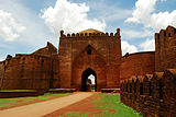
 Panoramic entrance view of Bidar Fort | |
 Scenic view of Bidar Fort Entrance | |
 Bidar Fort | |
| Coordinates | (17°55′19″N 77°31′25″E / 17.9219°N 77.5236°E)[1] |
| Type | Fort |
| Site information | |
| Controlled by | Government of Karnataka |
| Open to the public | Yes |
| Condition | Ruins |
| Site history | |
| Built | 15th century |
| Built by | Ala-ud-din Bahman of Bahmani Sultanate in 1424 |
| Materials | Granites and lime mortar |
Bidar Fort (Kannada ಬೀದರ್ ಕೋಟೆ, Urdu قلعہ بیدر) is situated in Bidar city of the northern plateau of Karnataka, India. Sultan Alla-Ud-Din Bahman of the Bahmanid Dynasty shifted his capital from Gulbarga to Bidar in 1427 and built his fort along with a number of Islamic monuments.[1][2][3] There are over 30 monuments inside the Bidar fort[4]
Geography
The fort, the city and the district are all affixed with the name Bidar. The city and the fort are located on the edge of an oblong shaped plateau, which measures 22 miles (35 km) in length and 12 miles (19 km) in width at its broadest, encompassing a total area of 12 square miles (31 km2). The ancient capital Kalyani (Basavakalyan) of Kalyani Chalukya is situated about 40 miles (64 km) to the west of Bidar.[1][5]
- River system
The Bidar city and the surrounding terrain in the district are drained by the Karanja River, a tributary of Manjira River, which in turn is a major tributary of the Godavari River.[5][6]
- Climate
Climate is salubrious throughout the year, even during the months of April and May in summer, sharp and sudden thunder showers cools the place. By early June the south-west monsoon dominates adding to the pleasant weather of the place. Winter is also a pleasant season. The city and the villages in its vicinity have a rich heritage of historical monuments and legends.[7]
History
The history of the present fort at Bidar is attributed to the Sultan Ala-ud-Din Bahman Shah the first sultan of the Bahmani dynasty to 1427 when he shifted his capital from Gulbarga to Bidar since it had better climatic conditions and was also a fertile and fruit bearing land. Earliest recorded history of its existence as a small and strong fort is also traced to the first Muslim invasion of the region is traced to Prince Ulugh Khan in 1322, whereafter it came under the reign of the Tughlaq dynasty.[1][2] With the establishment of the Bahmani dynasty (1347), Bidar was occupied by Sultan Alla-Ud-Din Bahman Shah Bahmani. During the rule of Ahmad Shah I (1422–1486), Bidar was made the capital city of Bahmani Kingdom. The old Fort was rebuilt and beautiful madrasas, mosques, palaces and gardens were raised. Mahmmad Gawan who became the Prime Minister in 1466 was a notable figure in the history of Bidar. Bidar remained under the Barid Shahi dynasty until it was captured by the Mughal emperor Aurangazeb in 1656 A.D. In 1724, Bidar became a part of the Asaf Jahi Kingdom of the Nizams.[1] It was annexed by the Bijapur Sultanate in 1619–20 but the Mughal viceroy of Aurangzeb took it in 1657 and thus became a part the Mughal Empire in 1686.[5] Third son of Asaf jah l ( Nizam l ) Nawab Said Mohammed Khan Asaf ud Daula ( Salabath Jung ) ruled from Bidar fort from 1751 to 1762 till his Brother Mir Nizam Ali Khan Asaf Jah III Imprisoned him in this fort, and was killed in Bidar fort in 16 September 1763. Mohammedabad old name of Bidar is also on his name.
Thus, Bahmanis ruled over Gulbaraga from 1347 to 1424 and from Bidar from 1424 till the extinction of the kingdom and its disintegration into five independent and warring kingdoms of Bijapur, Golconda, Ahmadnagar, Bidar and Berar. After India's independence, in 1956 when Bidar became part of Mysore (now Karnataka) state.[5][8][9]
Structure
With the establishment of the Bahmani Kingdom in the Deccan from 1347, the architectural styles of the Persian architecture of Iran made impressive and lasting impacts, which are seen in the Bidar Fort. The mosques, arches, gardens and the palaces were built within and also outside the fort in the Bidar city. Some of the important structures built are elaborated.[1][10] Innovative systems of water management are seen in and around the fort and city of Bidar.[11]
The influence of Persian culture was distinct in Bidar in the Deccan, during 15th and 16th centuries.[12]

The Bidar fort, constructed on the edge of the plateau, has a haphazard quadrangular layout plan of 0.75 miles (1.21 km) in length and 0.5 miles (0.80 km) breadth. The peripheral length of the fort walls measure 4,500 yards (4,100 m). The walls, bastions, gates and barbicans of Bidar, though in ruins, are well preserved and considered as some of the most stylish in India. It is surrounded by a triple moat.[1][5][8]
There are seven gates in the fort. The dominant main gate exhibits Persian style architecture. The ‘Gumbad Darwaza’ depicts arches with stilted size, also in Persian style. The ‘Sherza Darwaza’ of Bidar Fort, the second gate of entry, depicts two images of tigers carved on its fascia; according to Shia belief, the tiger decorations are indicative of Ali who was also known as Asadullah-Al Ghalib that assured protection to the building from enemy attack.[10] The other gates are the Fateh Gate on the south (has octagonal towers and drawbridge); the Talghat Gate in the east; the Delhi Gate and the Mandu Gate. The prominent bastion at the entry is known as the ’Munda Burj’ with guns positioned on it.[1]
It is said that the Bahmani Sultanate claimed lineage of the Sasanians and the motifs on their buildings, particularly the crowns of the arches that they built depicted a crescent and occasionally a disk that was closely reminiscent of the crowns of the Sassanian emperors.[13]
Takht Mahal

Takht Mahal also known as the throne palace is the part of the Bidar Fort. This particular monument was once used by the royals of the Bidar rulers as their residence. Notably, the Mahal has its entrance in the northern side but there are small doorways in other side of the monument as well.
- History
The Takht Mahal was constructed in between the period of 1426-1432 by the rulers of the Bahmani i.e. Ahmed Shah Bahmani. The Mahal lies in the west side of the Bidar fort. It was extensively used by the rulers during the period to address private audience of the kingdom. The structure of the building is deemed to be made following a complex design. The Mahal has a durbar hall were various ceremonies and important functions of the Kings of Bidar had taken place. Some of the notable events that have taken place within the fort include installation of kingdom of the Sultans of Bidar. In the present day scenario only the arches of the building remained and preserved well. The dome inside the monument was to be quite high and width which is also an attraction for the visitors. The chamber that was constructed within the interior of the Mahal was by used by the Bidar rulers as their throne rooms.

- Architecture
The architecture of the Mahal was influenced from the Indo-Islamic style. The features within the interior of the Mahal have relevance with the modern day architecture. The Mahal had a hot water swimming pool which was carved with granite materials from all sides. The figures and portraits in the interior of the Mahal portray the influence of the Islamic architecture while the floral designs in the walls depict the texture of the Hindu architecture. However, emphasizing on the arches within the Mahal, an influence of the Iranian architecture is quite apparent. In each of the eastern as well as western facades within the building, their lies an emblem of lion which further presents the relevance of the Persian architecture. The entire structure has the work of colourful tiles and mosaic the beauty of which increases with the sunrise. The throne room inside the palace has columned design which altogether form a rectangular structure each of which were carved with granite. The room were the royal guests and other important audience of the kingdom were addressed has big domes which are tinted with tiles and granite. A great view can of the low lying areas of the Bidar district can be experienced from the apartments of the royal residence of the Mahal.
Solah Khamba Mosque

The Bahmani architecture in Bidar shows elements of “fresh architectural forms” that fused local traditions and symbols of power with others imported from Western Islam, and evinced new and direct linkage with Central Asian decorative techniques. One such example of Bahmani architecture is the magnificent Solah Khamba Mosque.
- History
The Solah Khamba Mosque is one of the many ancient monuments that beautifully adorn the land of Bidar. Its establishment dates back to the days of the Sultans and that the monument exhibits features exclusive and grand.
From the name itself is understood that the monument is based on sixteen distinct pillars and has an enormous structure altogether. The domes, arches and the columns make the monument one of the largest amongst the others in the country. A large well situated behind the southern wall of the mosque is a major attraction.

It got its name for possessing 16 pillars that are lined in front of the structure. Built in 1424 by Qubil Sultani, this 90 meter by 24 meter mosque is popularly known as Zanana Masjid. Characterized by columns, arches and domes, this mosque is one of the largest in India.
This mosque served as the principal place of worship within the fort. It was founded in the early 14th century during the Tughlak occupation of Bidar but was extended later. . The masjid stands in a separate walled garden, Lalbagh. Waterways in the garden led from the Tarkash Mahal at the south to a royal bath at the north.
The Solah Khamba is set on a raised platform that opens eastward onto a rectangular esplanade, circumscribed to the east by a royal edifice called by Yazdani the Shahi matbakh, or “Royal kitchen”, referred to as the Crown Prince’s Palace.

At the center of the structure is a square, domed pavilion with arched openings on eastern, northern and southern sides, on the north and south are two smaller arched openings, now covered with jail screens. On each face of the three main arched openings we also find smaller arched openings some two and half meters above present ground level. On either side of this central pavilion are hypostyle halls with short, round columns supporting seventy domes on kite-shaped pendentives.
Diwan-I-Am

It was the ceremonial focus of the Bahmani and Barid Shahi rulers. The large rectangular court seen here once had timber columns of which only the granite bases remain. Some of the chambers opening off the hall have remains of tilework and geometric floor-patterns. The east wall seen here has a high parapet of trefoil crenellations. Arched openings below the parapet have pierced stone screens, each of a different design.
- History
This building was called the jali Mahal, on account of some screens of trellis work which were visible at the top of huge pile of debris lying on the site until some twelve years ago. Since then excavation have been conducted on an extensive scale by the Archaeological Department of Hyderabad, and they have disclosed not only the plan of the building but also remains as reveal, in their architectural and decorative features, the original grandeur of the whole.

The building is situated to the west of the Zanana enclosure, and it is approached by a road which proceeds straight from the latter enclosure. The outer wall of the Diwan-I-Am is preserved up to a considerable height on the southern side, but on the remaining three sides it raises only a few feet above the plinth and has been exposed to view by recent excavations. The building has two entrances, one through the eastern wall and other through the western, but they do not face each other. The excavations have exposed to view the original pavement of the eastern entrance, but the masonry of its outer and inner gateways, which must have comprised large blocks of carved stone, has all disappeared, perhaps carted away for use in modern buildings. The entrance on the outer side measures 9feet in width, but on the inner side it has become wider, apparently owing to the decay of the side walls at this end

The principal hall of the building, which was probably used for public audiences, is on the southern side and approached by five steps from the pavement. The hall is divided into three apartments by rows of pillars, six of them being arranged in each row. The total length of the hall is 109feet and 52feet 6inches in depth. These pillars of the hall were probably of wood, and they have all perished. The stone pedestals on which the wooden shafts rested are, however intact. The walls of the hall were originally decorated with panels of tile-work, some of them which have survived and currently being restored in museums. The colors of these tiles faded, for the tiles have reminded buried in debris for a number of years. It is said that two of these tiles were moved to a mosque in Bidar initially and later to a museum in Britain. One of the panels had a calligraphic text in the form of Swastika containing the name of “Ali”, the son in law of Prophet Mohammed, repeated four times in the Kufic script. These tiles were probably made by Persian craftsmen, for artists and technicians of the latter country were much patronized by the Bahmanis. The ceiling of the hall may again have been of wood. In the hall was placed the Takth-i-Firoza, Turquoise throne. At the back of the hall remains of a room may be noticed, the middle one may have been for the King. The floor had mosaic design comprising geometrical patterns such as hexagons and stars. There are two more rooms behind the King’s chamber, probably belonging to the ministers. The remains of walls in the south indicate an upper storey which had an arched screen built along its side
Tarkash Mahal
Tarkash mahal is situated in west side of the Bidar Fort. Sultan Alla-Ud-Din Bahman of the Bahmanid Dynasty shifted his capital from Gulbarga to Bidar in 1424 and built his fort along with a number of Islamic monuments among which "Tarkash Mahal" is the one.
- History
The Tarkash Mahal was constructed in between the period of 1426-1432 by the rulers of the Bahmani i.e. Ahmed Shah Bahmani. The Mahal lies in the west side of the Bidar fort. It was extensively used by the rulers during the period to address private audience of the kingdom. The structure of the building is deemed to be made following a complex design. The Mahal has a durbar hall were various ceremonies and important functions of the Kings of Bidar had taken place. Some of the notable events that have taken place within the fort include installation of kingdom of the Sultans of Bidar. In the present day scenario only the arches of the building remained and preserved well. The dome inside the monument was to be quite high and width which is also an attraction for the visitors. The chamber that was constructed within the interior of the Mahal was by used by the Bidar rulers as their throne rooms.
- Structure
The architecture of the mahal was influenced from the Indo-Islamic style. The features within the interior of the Mahal have relevance with the modern day architecture. The Mahal had a hot water swimming pool which was carved with granite materials from all sides. The figures and portraits in the interior of the Mahal portray the influence of the Islamic architecture while the floral designs in the walls depict the texture of the Hindu architecture. However, emphasizing on the arches within the Mahal, an influence of the Iranian architecture is quite apparent. In each of the eastern as well as western facades within the building, their lies an emblem of lion which further presents the relevance of the Persian architecture. The entire structure has the work of colourful tiles and mosaic the beauty of which increases with the sunrise. The throne room inside the palace has columned design which altogether form a rectangular structure each of which were carved with granite. The room were the royal guests and other important audience of the kingdom were addressed has big domes which are tinted with tiles and granite. A great view can of the low lying areas of the Bidar district can be experienced from the apartments of the royal residence of the Mahal.
Rangeen Mahal
Rangeen Mahal is one of the integral parts of the Bidar Fort. It was built by Ali Barid Shah(1542-1580 AD). The Mahal is also titled as the colored Mahal as it is decorated with tiles of diverse colors which can be depicted from the existed traces within the area of the fort.


- History
The monument was originally constructed by King Mahmud Shah Bahmani. Historical facts suggests that some part of the fort especially its part was built by Ali Barid Shah who was a Bidar ruler. The monument is believed to be one of the best preserved in the history of the state. The monument is also popular as the title of queen palace as women from various nationalities resided in it. This huge Mahal is closed by a famous darwaza which is also known as Gumbaz darwaza. It has been recorded that in order to gain power over the rivals in the year 1487, King Bahmani shifted from the royal palace to the rangeen Mahal. The king took shelter in the Shah Burz section of the Mahal. During his stay, the king experienced the feeling that the Mahal is favorable to stay and thus the king permanently shifted from the royal palace to the Rangeen Mahal. Furthermore, in the early 16th century, King Ali Barid took the initiative to improve the Mahal by improving its interior. The Mahal has a large hall where the visitors can be able to experience work of the ancient artisans during the 15th and 16th centuries.
- Structure

The Mahal depicts the artistic taste of the King of Bahmani and King Ali Barid. The architecture of the Mahal has a fusion of both the Hindu and Muslim art especially in the paintings and the decorations on the wall. Notably, traces remains within the Mahal suggested that aspects such as stone carving, stucco as well as floral work within interior of the Mahal are among magnificent feature of the monument. The interior of the hall has walls and ceilings which has the decoration of 'Mother of Pearl' along with mosaics. The wooden columns within the interior of the Mahal is also an important part of the architecture. The floor has the work of mosaic and colorful tile work which catches the attention of the eye. There are also verses of Quran written on the walls of the monument that portrays the religious aestheticism of its architecture. After it was redesigned by king Barid, some of the rooms were decorated with wood carvings and were ornamented with pearls. This also enhanced the beauty of the overall Mahal.
Bahamani Tombs
Bahamani tombs (also known as Ashtur Tombs) are situated in Bidar city of the northern plateau of Karnataka, India. Ashtur tombs are the tombs of Bahmani sultans.
- History
There are eight tombs of the kings of the Bahmani dynasty in this area, and their comparative dimensions and style of architecture demonstrate in the clearest manner the gradual deterioration of the political power of the dynasty. The earliest tomb is the one of Sultan Ahmed Shah Wali, who instated Bidar as the capital city.
Ahmed shah wali bahmani: Ahmed Shah Bahmani was a religiously inclined ruler, and accordingly fond the company of saintly personages. He was devoted to khwaja bande nawaz of gulbarga and later to the order of shah nimat-ullah of kirman whom he invited the founder to bidar. The title wali was used by order of the king in the religious address from the pulpit (khutba). According to his religious inclination, texts are engraved on the inner walls of his tomb. He also respected the doctrine of lingayats, a religious order of the deccan. The devotion of the latter sect to ahmed shah continues to this day, and at the time of the urs (annual celebrations of the death of a Muslim saint) their chief priest (jangam) comes from gulbarga to bidar to perform ceremonies according to lingayat rituals.
The architecture of his tomb, as indicated by its external features, shows strength combined with majesty, although except for the stucco work done in the arches, there is no decoration on the walls of the building. The walls are most massively built, their thickness being 12 feet. The dome of the building is three-fourths of an orb in shape with an octagonal base at the roof level, measuring 214 feet in girth, each side of the octagon being 26 feet. At its springing point, it has a circumference of 196 feet and its height including its finial is 107 feet measured from ground level.
The inner plan of the tomb comprises a square hall 52 feet on each side. There is a lofty arch in the middle of each of the four sides of the hall. The plan, accounting to these features looks pleasing to the eye, but the architect has further ornamented it by building squinches at the four corners of the hall, thus the building becoming octagonal at the top of the squinches. Above this, the plan is further changed making it 24 sided owing to the design below the circular base of the dome. The interior, although dark is artistically relieved by splashes of the most brilliant color combinations used to design the insides. For instance, in order to show with effect the brilliance of the gold creeper, an extremely dark background was used as you see in the above picture.. The practice of giving a while outline to the drawing which a view of suggesting an idea of depth to the subject could have been inspired by the ones in ajanta painted during the 5th and 6th centuries. There are textual forms of sayings by famous saints inscribed on many tablets inside this tomb. There are some more inscriptions on the life and times of ahmed shah wali. Another important feature of this painting is that one of them contains the name of the painter with a reference to his native place. The most elegant of all the paintings is the octagonal shapes of gold on the walls and inner side the dome.
The various features of this tomb, such as its vast dimensions, solid architecture, choice color schemes, and subtle decorative patterns, show the lofty ideals of the builder on the one hand and his exquisite taste and religious spirit on the other. This last mentioned quality is amply demonstrated by the holy texts inscribed on the building, as also by the ritual which is still observed by the votaries of the tomb, who although professing different faiths and belonging to different nationalities, all join together in paying their homage to the memory of the saintly king.
To the east of Ahmed shah’s tomb, but at a lower level, is a tomb which is assigned to the wife of the king. There is no inscription on the tomb and its internal decoration has perished with its usage as a dwelling by the locals. Its architecture is similar to that of ahmed shah’s but considerably smaller in dimensions. It must at one time, nevertheless, have been quite imposing as its built on a platform and the walls of the tomb rise to around 28 feet above the sultan’s own tomb. Inside, there are traces of paintings on the ceiling, but owing to neglect over the centuries, the designs have almost perished. There are five graves in this monument, of which the one at the extreme left is said to be that of ahmed shah’s wife.

There is another tomb to the south of Ahmed Shah Wali’s which is said to be of his son Hassan Khan. However, it is very untrue as Hassan Khan was Ahmed Shah’s nephew and was also a rival. So it is unlikely that he was buried at the royal cemetery. The tomb, in view of the above facts, probably contains the grave of one of the two princes of Mahmud Khan or Daud Khan, or perhaps both, for there are eight graves inside and it could have been the family vault of ahmed shah. From an architectural point of view, this building is not of much importance as it is comparatively very small than the others we had seen.
The next one is the tomb of Allauddin Shah, the eldest son of Ahmed Shah Wali. This tomb probably built during his lifetime should have been magnificent in those days with the colored tiles and floral designs. Much damage has been done to the tiles due to weather and vandalism of curious visitors who plucked the tiles till where hands could reach. The specimens which are intact show pleasing floral scrolls, geometric patterns and calligraphic motifs. The principal colors used were blue, green and yellow on white background, of which yellow was used as a contrast.
The black stone margins and along the decorative panels is a distinctive characteristic of this tomb. You can find these slender black stone bands at the four corners of the tomb where walls join one another. They are not only finely polished but also carved intricately which is very pleasing. The tomb has three doorways and the ornamentation on its exterior may perhaps at one time have given the same impression of splendor and glory as is produced by the tile decorated walls of the dome of the rock at Jerusalem. The name of the king with his title was given in the band of tiles above the southern doorway, but except the word sultan everything else has perished. The ceiling of the dome was originally painted, and a few fragments of them can be traced here and there. The interior of the tomb seems to have been used roughly by some uncultured people causing damage not only to the paintings, but also to the plaster on the walls. They unfortunately destroyed the sarcophagus over the grave and this has been rebuilt by the Archeological Survey of India (ASI).
Situated next to the one of Allauddin Shah, is the tomb of his son Humayun, the cruel. Probably in retaliation to his cruelty, nature showed its vengeance. The tomb was struck by a lightning in recent times and the larger part of its dome and walls have fallen down. The debris of the dome was lying inside till the 19th century after which it was cleared by the ASI. The architecture of this building, even though not much pleasing, is different from the ones constructed before, particularly in the arches. This arch construction was later predominantly used in the buildings of Adil shahi and the Baridi dynasties. The tomb at its base measures 77 feet on each side externally and the thickness of the walls is 13 feet. Steps are built in the thickness of the walls which lead to the roof. The tomb is entirely built of black trap masonry laid in lime, but the upper courses of the dome are built in light spongy brick which float in water. When asi sent samples of these bricks for examination, it was found that the quality of these is far superior than those found in the Ramappa temple in Warangal.
The next in line is the tomb of sultan Nizam Shah, which is to the west of Humayun’s tomb. The tomb is left incomplete due to the demise of the queen mother a few years later. Though small, the walls of this tomb rise to a height of 25 feet from ground level. The external dimensions are the same as the other royal tombs. It is very likely that the architect had initially planned a dome as the structure is massive enough to withstand the load. The exterior of the tomb towards the south has a large arch in the middle which forms the entrance.
Next is the tomb of sultan Muhammed Shah-III, entitled lashkari which is also incomplete. The reason could be even if he ruled for nineteen years, he was merely a puppet in the hands of the queen mother and the two ministers, Khwaja jahan Turk and Mahmud Gawan. His tomb is almost similar to that of Nizam shah except that the dimensions of the arches vary a little. It is possible that it had been designed by the same architect. There are three graves inside and one of them must have belonged to Muhammed shah’s wife.
The title Malika-E-Jahan is commonly given to the queen consorts during the Bahmani and subsequent dynasties when they ruled, but here it specifically refers to the wife of sultan Humayun who played a very important role in deccan politics during the reign of her minor sons, Nizam Shah and Muhammed Shah-III. She retired from state affairs and devoted to religious activities once Muhammed Shah became old. The Malika’s tomb is a little smaller than that of her husband and two sons. With respect to ornamentation, it has good stucco work which gives a pleasing look. There are four graves below the vault and the one right in the middle of the vault is of the queen.

The tomb of Mahmud shah bahmani is one of the most imposing structures in the vicinity. He also ascended the throne at the age of twelve years. He took control of the kingdom from the de facto rule of ministers and ruled for thirty six years and probably had his tomb built during his lifetime. His tomb also possesses all the solid dignity of the tombs of the earlier bahmani kings but lacks in austerity for it does not either have decorative tiles on its outside or paintings inside. The walls rise to a height of 45 feet and strongly support the gigantic dome and are crowned by a parapet of 5 feet. The enclosure walls measure 77 feet on each side and has a wide arch in the center of each wall. There are smaller arches above this arch and this is a common pattern followed all across the building. The dome has an octagonal base on the roof and its circumference at the springing point is 206 feet. The interior of the tomb is somewhat sombre with light entering through windows filled with trellis work. Apart from some minor designs here and there, there is no decoration found but the tomb is consistent in its massive and spacious interiors which is a signature of the earlier Bahmani tombs.
There are two unidentified tombs. They are supposedly of two puppet kings Ahmed Shah and Allauddin who were placed on the throne by Amir barid in 1518 and 1521 AD. Of these two sepulchres, one has a conical dome with eight facets, which are marked by plaster ribs. The interior of the tomb is square measuring only 15 feet. The walls have an arch on each side with a parapet of 2 feet above. The second sepulchre is incomplete. The walls of this building have not been plastered but traces of a tomb were noticed and the building restored by the ASI.
- Gallery
-
 Ahemed's Wife's Tomb
 -
 Mahmud Shah's Tomb
 -
 Nizam Shah's Tomb
 -
 Wall of Tomb


Gagan Mahal

Gagan Mahal situated in Bidar Fort is a previous palace of DAKAMANIS. It consist of multi-bay vaulted halls facing on to small internal courts.Architecturally, the structure is a combination of strength and beauty. The palace has two courts, the outer one apparently used by the staff and the guards of the palace and the inner one for the royal ladies. The main building of the palace lies to the south of the inner court and was used by the Sultan.Its a public audience hall,which is decorated with splendid mosaics.The palace can be approached through black granite steps,interlinked between red standstone.The palace is adorned with magnificent arches and colored tiles. This palace was used by the king for his harem.
- History
The Gagan Mahal (heavenly palace) was originally built by Bahamani kings (14th and 15th centuries AD), and some alterations and additions were made by the Barid Shahi rulers. It has two courts. The outer court was used by the male staff and guards. The inner court also, there are rooms on either side of the covered passage for the accommodation of the guards. The main building of the palace was for the use of the sultan and his harem. In fact, there are buildings with the same name in Anegondi (Hampi), Bijapur, Mudgal as well. Aptly named the Heavenly Palace,notably the northern wing and the upper apartments of the southern.
There are arcades on either side of the long inner court, the remains of which may be seen today. The arcades to the north have been merged to the basement of the Tarkash Mahal which was built at a later date than the Gagan Mahal. The eastern and western parts have openings into the court which is said to have shown a nice proportion. In the ground floor, is an open space in the form of a pavement. There is a doorway through the pavement which leads to a double hall divided into six bays.
- Architecture
The palace has two courts, the outer apparently used by the male staff and the guards. Its entrance is behind the Solah Khamb mosque. On the southern side of the court is a series of rooms and halls build in rows one behind the other. Is is said that one the inside, there are arched entrances to all these rooms which were decorated with stucco and tile work.The Gagan Mahal was aptly designed and decorated for a King with the queens harem.There is a terrace going up which commands a good view of the neighbouring buildings. This terrace is also currently blocked.Looking across the gardens in the core of the fort towards the ruinous Gagan Mahal.

The Gagan Mahal was aptly designed and decorated for a King with the Queens harem. There is a terrace going up which commands a good view of the neighboring buildings. This terrace is also currently he Gagan Mahal (Public Audience Hall)or palace in Persian architectural style in Bidar city has glazed mosaics and has an approach with arresting black granite steps inter laid with red sandstone. It has stilted arches.
They are all in mosaic of beautiful coloured tiles.Aptly named the Heavenly Palace.There are two outlines on each of the eastern and northern façades. Persian emblems of the Lion along with the raising Sun in the background flank the arches on both sides. The palace has two courts, the outer apparently used by the male staff and the guards. Its entrance is behind the Solah Khamba Mosque. On the southern side of the court is a series of rooms and halls build in rows one behind the other. Is is said that one the inside, there are arched entrances to all these rooms which were decorated with stucco and tile work.
Baridi Shahi rulers made certain alterations and additions in the plan of the building mainly in the northern wing of the palace and the apartments on the upper storey of the southern block. The rooms belonging to the ground floor of the latter block are however of the Bahamani period. With respect to architecture, the structure is a combination of strength and beauty. The main building of the place lies to the south of the inner court and is used by the Sultan. Bidar Fort is situated in Bidar district of the northern plateau of Karnataka, India. Sultan Alla-Ud-Din Bahman of the Bahmani Dynasty shifted his capital from Gulbarga to Bidar in 1427 and built his fort along with a number of Islamic monuments.
Chaukhandi
Chaukhandi of Hazrat Khalil Ullah is a tomb built in honour of Hazrat Khalil Ullah, the spiritual adviser of Sultan Ahmed Shah, a Mughal emperor. This two-storied structure is an octagonal shaped tomb.
- History
Chaukhandi is a compound Hindi word, meaning a four-storeyed building. Although the building itself is double-storeyed, the term has been applied as it is situated at a high ground and reached by a flight of steps. Hazrat khalil-ullah was the son of shah Nimat Ullah kirmani; the former came over from his native place to Bidar in 1431 AD during the reign of allauddin shah wali Bahmani and his sons were married to the royal princesses.

The Chaukhandi has three graves in the main vault and several others in the corridor. The tomb is approached from the road which goes from the Dulhan darwaza to the bahmani tombs. To approach the outer gateway of the tomb, a visitor has to ascend a flight of steps and walk across a long pavement which has intermediate steps. There is a façade at the end of the pavement, comprising an arch in the middle and a parapet of trefoil pattern at the top of the wall. The arch has a stilt at the top showing Persian influence. There is a panel with medallions of stucco work which contains the names of Allah, Mohammad and Ali written in the Kufic script but arranged in the tughra style.
Just outside the gateway, there is a hall to the left which is barred for entrance. It has three arches and its ceiling is divided into three compartments built across its width, each compartment containing a vault. The upper hall of this building was originally used by musicians, who played on trumpets and drums at the four watches to maintain the ceremonial dignity of the shrine. Passing through the gateway, the visitor has to ascend some steps to reach the passage. On either side of the passage at this stage are a large number of graves belonging to shah khalil-ullah and his successors. From here, there are again a fleet of stairs after which we reach the building.
The Chaukhandi appears to have been designed by the same architect who planned the tomb of sultan Allauddin, for there is much in common in the decorative schemes between the two. However, their ground plans are different as the Chaukhandi is octagonal unlike the other which is square. The walls of the Chaukhandi were originally decorated with encaustic tiles, the trace of which are found only in a few places. Black stone borders have been done for the this tomb as well as we had seen on the tomb of sultan Allauddin. There are arches on two levels which is again a similarity of the two buildings. The walls are built of black trap masonry laid in lime and they are very massive in construction.

The interior of the tomb is approached by a covered passage from the arch facing south. The tomb of the saint, which is built in the middle of the interior of the Chaukhandi, as a square plan externally and an octagonal plan internally. The walls are decorated with stucco work both inside and outside. In later times, separate vaults have been built for the graves of the descendants of shah khalil-ullah, one of which is attached to the Chaukhandi itself and may be noticed in the form of a projection to the east of the passage. Over the doorway of this vault the date of 1675 AD. Is carved which show that it was built after the conquest of Bidar by aurangzeb in 1658. Inside the vault, there are nine graves. The inscription in the thulth style of writing which beings from the main doorway of the Chaukhandi is continued till the inner corridors. It was designed by a calligraphist of shiraz named Mughith. To the east of the Chaukhandi, until some 70 years ago, stood a tomb which has since perished completely, but photographs of its exterior and interior were fortunately taken by the archaeological department in 1917. It was not of large dimensions but had distinctive decorative features which made the building picturesque.
The Chaukhandi, apart from its lofty position, which has made it a prominent feature in the panorama of Bidar, possesses certain architectural merits placing the monument among the best constructions of the bahmani period. It is now denuded of much of its splendor, but its stately arches, neat carving, and magnificent calligraphy and artwork show the highest quality of Bahmani architecture, which probably reached during the reign of sultan Alauddin, whose own tomb has similar decorative features as the Chaukhandi.
Madrasa of Mahmud Gawan
The Madrasa of Mahmud Gawan is situated in Bidar City of the northern plateau of Karnataka, India. It was constructed by Mahmud Gawan, Mahmud Gawan was not only a great warrior but also a great administrator. His contribution to Deccan History was the great Madrasa. He established it in 1472 AD.
- History
Mahmud Gawan, being from Persia and as he was continually was in correspondence with eminent personages of his home country, it is not unlikely that he bought engineers and craftsmen from that country to design this building. He, under the aegis of the Bahmani Kings, who were enthusiastic patrons of learning and literature, was thus able to have this college at Bidar on the same magnificent lines as its prototypes in Khurassan and other Islamic countries, and he not only staffed it with eminent divines, philosophers and scientists, but also equipped it with a library of 3000 valuable manuscripts.

The first view of this unique monument is itself enough to understand the importance it had during that time. The ASI took over this monument in 1914 and has put in a great deal of effort in conserving it. Lets get inside the complex and talk about each part of it.
- Architecture
The building has a high basement, but to make the approach convenient, two terraces have been built in front it. The main entrance has vanished, but its floor has been exposed by excavations carried out in recent times and the plan shows that the whole comprised an outer arch 21 feet in span and an inner 10 feet in span. The height of the arch was around 45 feet from the floor level. Beyond the entrance was a portico, square at the base. The roof of the portico probably had a dome structure similar to those above the roofs of the semi octagonal projections that you see one three sides. The other three projections rise to a height of 90 feet There were passages from the portico to the inner building, but today only the pavements and remains of walls are seen.
The minaret at the northern end of the facade and the wall adjoining it towards the south are comparatively the best preserved portions of the Madrasa, although their tile decorations have survived only in fragments. The minaret has an octagonal base, 67 feet from ground level and has three storeys where the first and second have balconies, which project from the main body of the tower, but has no brackets to support them. The absence of brackets signify a typical Persian construction. The lower part of the tower was decorated with tiles arranged in a chevron pattern, the colors being green, yellow and white. Owing to rain water, most of the tiles have fallen down but the remaining ones convey a clear idea of the decorative schema of the tower. For the purpose of variety, each storey at the neck point had calligraphic devices on mosaic tiles with white letters fixed over a deep blue background. The total height of the tower is 131 feet from ground level. The top of the tower looks somewhat dumpy and does not possess any grace.

The wall adjoining the tower towards the South forms the faã§ade of a mosque built in the north-eastern part of the building. This wall extends at present to a length of 59 feet and has an elevation of 65 feet from floor to the upper terrace. The architect in order to produce an effect of light and shade in the building has divided the faã§ade into several compartments, two of which have deeply recessed arches with screens of trellis-work at their back. Details of the faã§ade include a band of tile-work containing a parapet design with white, yellow and blue tiles arranged in artistic manner. Below this band, comes another broader one containing an extract from the Quran. Below the calligraphic band, which is of a rather intricate pattern, there is another comprising little squares arranged in the form of stars. Below the three bands of tile-work, there is a broad compartment, containing five arches, the side walls of which are again decorated with beautiful tiles.
The second or middle compartment also contains arches which are also decorated with tiles. The third compartment, which adjoins the plinth of the building, comprises five rectangular panels where the middle one has a doorway and a window on top of it. The other panels also have windows with jalis of delicate patterns.
The interior of has plain but lofty style of architecture appropriate to a place of worship. The hall is 49 feet in length and 24 feet in width. Corresponding to the mosque and adjoining the minaret, was the library, which has completely perished. But as architects of the East generally design the wings of the building in a uniform plan, it is not unlikely that the plan of the library is a replica of that of the mosque.
By entering the building through the opening where the main gateway once stood, and following the either of the two passages to the right and left of the porch, the inner court is reached, which measures 103 feet and has a dodecagonal cistern in the middle. It was a large one where its water was apparently supplied by a subterranean channel from the well in the forecourt of the building. The marginal slabs of this cistern are now missing, and its current depth is only 3 feet.
As the northern and western wings of the building are in a better state of preservation than those of the other sides, it would be best to begin the description of the different apartments of the Madrasa from its northern wing. At the extreme eastern end of this wing, adjoining the mosque described above, is a square hall with a dome shaped ceiling which measures 27 feet on each side at the base, but its corners are slightly cut The walls are plan but there are series of receding arches combined with the elegant design in the northern projection of the hall, take away any monotony from the building. The hall was apparently meant for the residence of the principal teacher of the Madrasa who would have acted also as the Imam. Corresponding to this hall there was another in the southern wing of the building which has completely disappeared, but its plan has been determined by the excavations carried out the Archaeological Department.
It is said that the southern wing got demolished by a lightning, however, the actual reason was different. After the capture of Bidar by Aurangzeb in the latter end of the 17th century, these splendid range of buildings were used as a storage of powder magazine and barracks for a body of cavalry, when by accident the powder exploded destroying the greater part of the edifice causing dreadful havoc around. All we can see in this wing is a large gaping hole on one side the building with the arch and a pillar as silent witnesses of the destruction.
Beyond the latter two halls, the plan on the northern and southern wings of the Madrasa is uniform, comprising a large hall in the middle with pairs of student rooms built on either side of it. These rooms rise to three storeys and there is a verandah in front of each with an arched opening towards the court. Each student accommodation consists of two rooms where the inside one was a sleeping quarter. The back rooms of these apartments are fitted with windows opening on grounds surrounding the buildings. The windows were originally fitted with jalis. Of elegant designs which were restored in recent times. The arrangement of the apartments shows that the architect has taken into consideration the comfort of the students in all seasons of India. There are thirty six suits of these rooms in all the three storeys of the building and according to the estimate, if we consider each suite to accommodate three students, the Madrasa was capable of accommodating 108. The halls in the middle were meant to be lecture halls where you can see calligraphic texts here and there. At the north-west and south-west corners, the architect had planned rooms for professors, which are not only comfortable for living but also have pleasing designs.
The architect has planned a platform all round to make the structure more secure. The walls of the Madrasa measure exactly 242 feet from east to west and 220 feet from north to south. They are built of rough-tooled masonry, which has been covered with plaster and emblazoned with tiles.
Baridi Tombs
Towards the beginning of the 15th century, a new line of rulers, the Baridis gained control of the territory around Bidar. Their tombs stand is a necropolis just west of the city walls. The tomb seen here on the right is of Khan Jahan, brother of Amir I, the second Baridi sultan. It stands on a high platform in the middle of the walled garden which has elaborate walkways and water channels. The tomb walls have two tiers of double arches decorated with incised plaster work. The panel above central arch has three symmetrical diagonal squares. The flattish dome rises above a high parapet with corner finials. The simple structure on the left, called Barber's tomb has a dome raised on an unusually high, octagonal neck.
The two-storeyed entrance gateway is to the south of Ali Shah's tomb. The gateway has double tiers of wide arches, three in each story. A row of diagonal squares runs just below the crenellated parapet. The arch above the entrance has an inset of a triple arched window, while flanking arches have a single window at the centre.
Its one of the historical monument in Bidar belonging to one of different periods of history some of the design,decorative patterns seen in the monuments are unique. The tombs of rulers of Barid Shahi dynasty are among the top tourists attractions in Bidar. The tomb is located on a high platform in the middle of incredible garden on the west of Bidar town,it has many historical,architectural & religious importance. Its built on platform with a flight of well polished.The five horizontal bands above the arched facades were intended for colored tile work. The parapet and the base of the massive dome are elaborately treated with trefoil elements. The inside walls of the tomb have double tiers of arched recesses flanking each entrance. Here some tilework remains, adorning the arch tassels, apex, and the rows of horizontal bands above the arches. A continuous band at the top of the walls is also filled with tilework and calligraphy.It lie about 2 km west of Bidar there were formerly gardens around them.The first town is Qasim Barid .It resembles the sculptures of Wali-Ullah Bahamani and Klim-Ullah Bahamani.
Barid Shahi Park is where the Baridi Sultans of the Bidar Sultanate having their final rest. The government has build up a park around it. Amir Barid, it appears, began construction of his tomb during his own life time. But he died suddenly at Daulatabad and his tomb remained incomplete. This is an imposing edifice constructed on a platform, with lofty portals in the south. There is spacious hall without roof in this tomb. Ali Barid too built his own tomb which shows great improvement upon the Bahamani mausoleums. Its platform measures 47.28 on each side. The enclosures walls rise to a great height. There is large dome with a circular base decorated with niches and moldings. A mosque consisting of an open court, a cistern, a prayer hall and an arcade is attached to the tomb. The Sepulchers of Ibrahim Barid is of the same type as that of his father Ali Barid and likewise presents a stately appearance. In this building, there are three graves, the central one being that of Ibrahim Barid and the other being of his wives. There are other tombs of the members of Ibrahim Barid's family. The tomb of Qasim Barid II faces, the grave of Ibrahim Barid. It has been built on a 1.83 Meters high platform with well-dressed steps. The circumference of its doom measures 25 meters. The walls on each side have big arch. The tomb of the wife of the Sultan is also by the side of her husband's tomb here. Khan Jahan, who was the son Qasim Barid, might have constructed his mausoleum during his own life time. It is built with well-chiseled masonry and has steps on all four sides. The dome rests on a circular drum.
The tomb of ALI BARID SHAH , which looks simple from the outside turns out to be the finest examples of Islamic Architecture . Another unique factor of tomb is that Amir Barid started building his own tomb while he was still alive. This is an imposing edifice constructed on a platform, with lofty portals entrances in 16th century in the south. There is spacious hall without roof in tombs. Its one of the most prominent tomb having symmetrical domes and engraved plaster work. There are 3 symmetrical diagnose squares in central arch with a high parapet rising above a flattish dome.
Chaubara
The Chaubara is right in the middle of a densely populated area and the traffic that flows somehow reduces a tourist’s interest towards it. However, it was one of the important monuments of the ancient time.
This cylindrical tower is built where two principal thoroughfares of Bidar cross each other. One of them extends from the Fort to the Fateh Darwaza, and the other connects Mangalpet to the Shah Gunj Darwaza. The tower is reported to have built in the pre-Islamic period, but its style of architecture is Islamic, and it was probably constructed as an observation post simultaneously with the other fortifications of the town by Ahmed Shah Wali or his immediate successors. The tower rises 71 feet above ground level and from the top commands a view of the entire area and also the low lands stretching beyond in every direction. The prefix Chau in Hindi as well as Persian signifies the four directions, while bara in Persian means a fortified place where it means a house in Hindi. The entire structure is most massively built and its shape resembles that of the towers of some of the early mosques of Western Asiatic Countries, notably that of the great mosque at Samarra. The only difference is that the steps leading to the top of the Samarra tower are built along the outer surface of the structure, whereas its counterpart in Bidar has the steps built in its interior.

The tower has a circular base, 180 feet in circumference and 16 feet 9 inches in height., with arched niches built along its lower parts. These may have been occupied by the guards who kept watch here, or resorted to by pedestrians when taking short rests during journeys. The front of the base is disfigured by a police station for a short period, however it was taken down later exposing the full façade of the monument. Simultaneously with the building of the police station, a large clock was installed on the top of the tower. This clock, being somewhat incongruous was removed for some time but now it reappears. This is the plight of some of the monuments of India where either locals or the government departs do not strive to keep their sanctity.The steps which lead to the terrace of the basement start from a door which faces east. The girth of the tower at the terrace level is 114 feet and a space has been left all around it to enable visitors to walk around on foot. However, today the entry to the top is barred to everyone. At this level, there is a winding staircase comprising 80 steps which leads to the top of the tower. The summit is 53 feet above the basement. The entire tower is built of black trap masonry laid in lime and strengthened by circular bands at two places in its height. The dimensions of the tower are no doubt colossal, but pillars of this shape are frequently to be noticed in Islamic buildings of the 14th and 15th centuries in India. We can find pillars like these in the Feroz Shah Kotla Mosque in Delhi, Mubarak Khalji’s mosque in Daulatabad and the Bahmani Idgah in Bidar. The staircase of the tower has an arch shaped vaulted ceiling which is not to be found in pre-Islamic constructions. The tower has four rectangular openings pierced in its walls to let in light and air.
Hazar Kothri
Hazar Kothari was meant for exit in the event of an enemy attack, it is located in the south of Takath Mahal. In case of Danger to the life while attack from the enemies, the members of the Royal Family need safe exit out of the Fort. Such a safe passage arrangement can be seen on a spot towards the south of the Takhat Mahal. It is known as the Hazar Kothari.
There is an underground hall for assembling and from there a cave like tunnel which leads to outer wall of the fort India. Sultan Alla-Ud-Din Bahman of the Bahmani Dynasty shifted his capital from Gulbarga to Bidar in 1427 and built his fort along with a number of Islamic monuments. The fort, the town and the district are all affixed with the name Bidar. The walls, bastions, gates and barbicans of Bidar, though in ruins, are well preserved and considered as some of the most stylish in India. It is surrounded by a triple moat. There are seven gates in the fort. The dominant main gate exhibits Persian style architecture. The ‘Gumbad Darwaza’ depicts arches with stilted size, also in Persian style. The ‘Sherza Darwaza’ of Bidar Fort, the second gate of entry, depicts two images of tigers carved on its fascia; according to Shahi belief, the tiger decorations are indicative of Ali who was also known as Asadullah-Al Ghalib that assured protection to the building from enemy attack. The other gates are the Fateh Gate on the south (has octagonal towers and drawbridge); the Talghat Gate in the east; the Delhi Gate and the Mandu Gate. The prominent bastion at the entry is known as the ’Munda Burj’ with guns positioned on it. The history of the present fort at Bidar is attributed to the Sultan Ala-ud-Din Bahmani Shah, the first sultan of the Bahmani dynasty, to 1427 when he shifted his capital from Gulbarga.
Earliest recorded history of its existence as a small and strong fort is also traced to the first Muslim invasion of the region is traced to Prince Ulugh Khan in 1322, where after it came under the reign of the Tughlaq dynasty. With the establishment of the Bahmani dynasty (1347), Bidar was occupied by Sultan Alla-Ud-Din Bahman Shah Bahmani. During the rule of Ahmad Shah I (1422–1486), Bidar was made the capital city of Bahmani Kingdom. The old Fort was rebuilt and beautiful madrasa’s, mosques, palaces and gardens were raised. Bidar remained under the Barid Shahi dynasty until it was captured by the Mughal emperor Aurangazeb in 1656 A.D. It was annexed by the Bijapur Sultanate in 1619–20 but the Mughal viceroy of Aurangzeb took it in 1657 and thus became a part the Mughal Empire in 1686. In 1724, Bidar became a part of the Asaf Jahi Kingdom of the Nizams. Third son of Asaf jahi l (Nizam l ) Nawab Said Mohammed Khan Asaf ud Daula ( Salabath Jung ) ruled from Bidar fort from 1751 to 1762 till his Brother Mir Nizam Ali Khan Asaf Jah III Imprisoned him in this fort, and was killed in Bidar fort in 16 September 1763. After India's independence, in 1956, Bidar became part of Mysore (now Karnataka) state.There is an underground hall for assembling and from there a cave like tunnel which leads to outer wall of the fort. There is long gun bastion near Veerasangayya's Temple situated on the bank of a tank known as Bomgondanakere. On the northern side is the Purana Killa.Importance in the past, it provided safe exit out of the Fort and helped improve security to the natives of the fort and kingdom.
Karez(Ancient water supply system)
One of the most unique features of Bidar is the historic Karez[14] system (also known as Qanat) which is a water harnessing technology that originated in Iran/Persia. The ‘Karez’ system in Naubad village, Bidar is of great historic significance dating back to almost 500 years. The karez technology basically taps into the ground water sources (or natural springs) and transports it through an underground tunnel to the settlement, ending in surface canal and/or pools in the village for various uses like drinking, washing, ablution, watering livestock, and also further used for irrigating fields, orchards and gardens.

- History of Karez
- The original Persian term for Karez is Kariz and the rest of the world has yielded many names for this system; like in North Africa it is called “Fugara”, “Falaj” in Arabia. “Qnat Romani” in Jordan and Syria, “Galerias” in Spain “Kettharra” in Morocco, “Kanjering” in China and “Kariz” in Afghanistan and Pakistan.
- The Karez is found in 38 countries worldwide and of course most of these are concentrated in the Middle East region. Persia is known for the earliest known and documented Karez system.
- The Muslim dynasties with ruling class descending from Persia or having influential connections with Persian kings may have invited expert engineers from Persia.
- The silk route may have been the information highway to transfer the cultural and traditional knowledge.
- Introduction of Karez in India
- Karez system was built by Bahmani kings in 15th Century in Bidar, Gulbarg and Bijapur in Karnataka and also in Burhanpur in Madhya Pradesh.
- Karez is nothing but the underground canals, built to underground water streams which are meant to provide drinking water to civilian settlements and garrison inside the Bidar fort.

- This system was necessary in a city like Bidar where the soil was rocky and drilling wells to accommodate drinking water was difficult.
It is believed that the Muslim rulers of Bidar, under the expert advice of Persian engineers followed Karez system by laying subterranean canals in the heart of the rock by widening the natural rift.
- The Naubad Karez is estimated to have been constructed during the Bahmani Period (1347 – 1518 AD). The Karez was probably directed towards developing infrastructure for a village at Naubad.
Access
Bidar is well connected by road, rail and air links. Bidar city is situated about 740 kilometres (460 mi) north of Bangalore India on NH 7, 116 kilometres (72 mi) northeast of Gulbarga and 130 kilometres (81 mi) on NH 9 from Hyderabad.
Airport
- Nearest airport is the Rajiv Gandhi International Airport Hyderabad
- Bidar Air Force Station is occasionally used during VIP visits.
- Kempegowda International Airport, BANGALORE.
Access to Bidar Fort
Bidar Fort is 115 km from Hyderabad, India.
In popular culture
The song Ishq Sufiyaana from the hit Bollywood film of 2011, The Dirty Picture was shot in the Bidar Fort. The song had sequences in the fort with Vidya Balan and Emraan Hashmi.
See also
- Bahmanid Dynasty
- Forts of Karnataka
- Raichur Fort
- Gulbarga Fort
- Bellary Fort
- Basavakalyana Fort
- Mudgal Fort
External links
- Bidar fort stands the test of time
- A platform to gaze upon moonlit skies
- Escape route near royal harem found at Bidar Fort
Gallery
-
 Bidar Fort near the entrance.
 -
 Gateway to Bidar fort
 -
 Rangeen Mahal
 -
 Frescoed calligraphy
 -
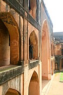 Archways in the fort
 -
 Front view of Bidar Madrasa


References
- ^ a b c d e f g "Heritage araeas". National Informatics Centre. Retrieved 2009-11-07.
- ^ a b Islamic culture, Volume 17. Islamic Culture Board. 1943. pp. 27, 30. Retrieved 2009-11-07.
{{cite book}}:|work=ignored (help) - ^ "Bidar City Municipal Council". Tourism. Government of Karnataka.
- ^ "Not many follow the compass pointing north". Kasturi & Sons Ltd. The Hindu. 18 January 2015.
- ^ a b c d e "Geography and travel". Encyclopædia Britannica. Archived from the original on 4 December 2009. Retrieved 2009-11-08.
{{cite web}}: Unknown parameter|deadurl=ignored (|url-status=suggested) (help) - ^ "Bidar: River systems and drainage". National Informatics Centre. Retrieved 2009-11-08.
- ^ "Bidar: The Land". National Informatics Centre. Retrieved 2009-11-08.
- ^ a b Sherwani, Haroon Khan (1969). Cultural trends in medieval India: architecture, painting, literature & language. Asia Pub. House. pp. 14–16. Retrieved 2009-11-07.
{{cite book}}:|work=ignored (help) - ^ "Gulbarga Fort". British Library On Line gallery. Retrieved 2009-11-07.
- ^ a b Joshi, P. M. (1996). Mediaeval Deccan history: commemoration volume in honour of Purshottam ... Popular Prakashan. pp. 44–45. ISBN 978-81-7154-579-7. Retrieved 2009-11-07.
{{cite book}}:|work=ignored (help); Unknown parameter|coauthors=ignored (|author=suggested) (help) - ^ Sohoni, Pushkar and Klaus Rötzer, ‘Nature, Dams, Wells and Gardens: The Route of Water in and around Bidar’ in Daud Ali and Emma Flatt (ed.), Garden and Landscape Practices in Pre-Colonial India (New Delhi: Routledge, 2011), pp. 54-73.
- ^ "Bidar". Encycopeida Iranica. Archived from the original on 19 December 2009. Retrieved 2009-11-08.
{{cite web}}: Unknown parameter|deadurl=ignored (|url-status=suggested) (help) [dead link] - ^ "Sasanian Royal Emblems and their Reemergence in the Fourteenth-Century Deccan". Retrieved 2009-11-04.
- ^ http://www.gounesco.com/karez-system-bidar
| Ahom dynasty | |
|---|---|
| Bahmani Sultanate | |
| British Raj | |
| Deccan sultanates |
|
| Delhi Sultanate | |
| Eastern Ganga dynasty | |
| Faruqi dynasty | |
| Gujarat Sultanate | |
| Jat | |
| Kakatiya dynasty | |
| Kingdom of Mysore | |
| Malwa Sultanate | |
| Maratha Empire | |
| Mughal Empire | |
| Nayak dynasty | |
| Portuguese |
|
| Rajputs | |
| Sikh Empire | |
| Siddi | |
| Sur Empire | |
| Travancore | |
| Vijayanagara | |
| By state |
|
|---|---|
| By city |
|
| Types |
|
| Organisations |
|
| See also | |